
19 April 2021
Landslides from the 18 April 2021 M 5.9 earthquake near to Bandar Genaveh, Iran
Landslides from the 18 April 2021 M 5.9 earthquake near to Bandar Genaveh, Iran
On 18 April 2021 a M=5.9 earthquake struck the port city of Bandar Genaveh in Iran. The earthquake was centred on the town of Bandah Rig. There are some reports of damage in Bandah Genaveh, and five people were injured.
A couple of videos have been posted of landslides triggered by the earthquake. The best one is on Youtube:-
.
Inland from Bandah Genaveh there is a steep escarpment running sub-parallel to the coast:-
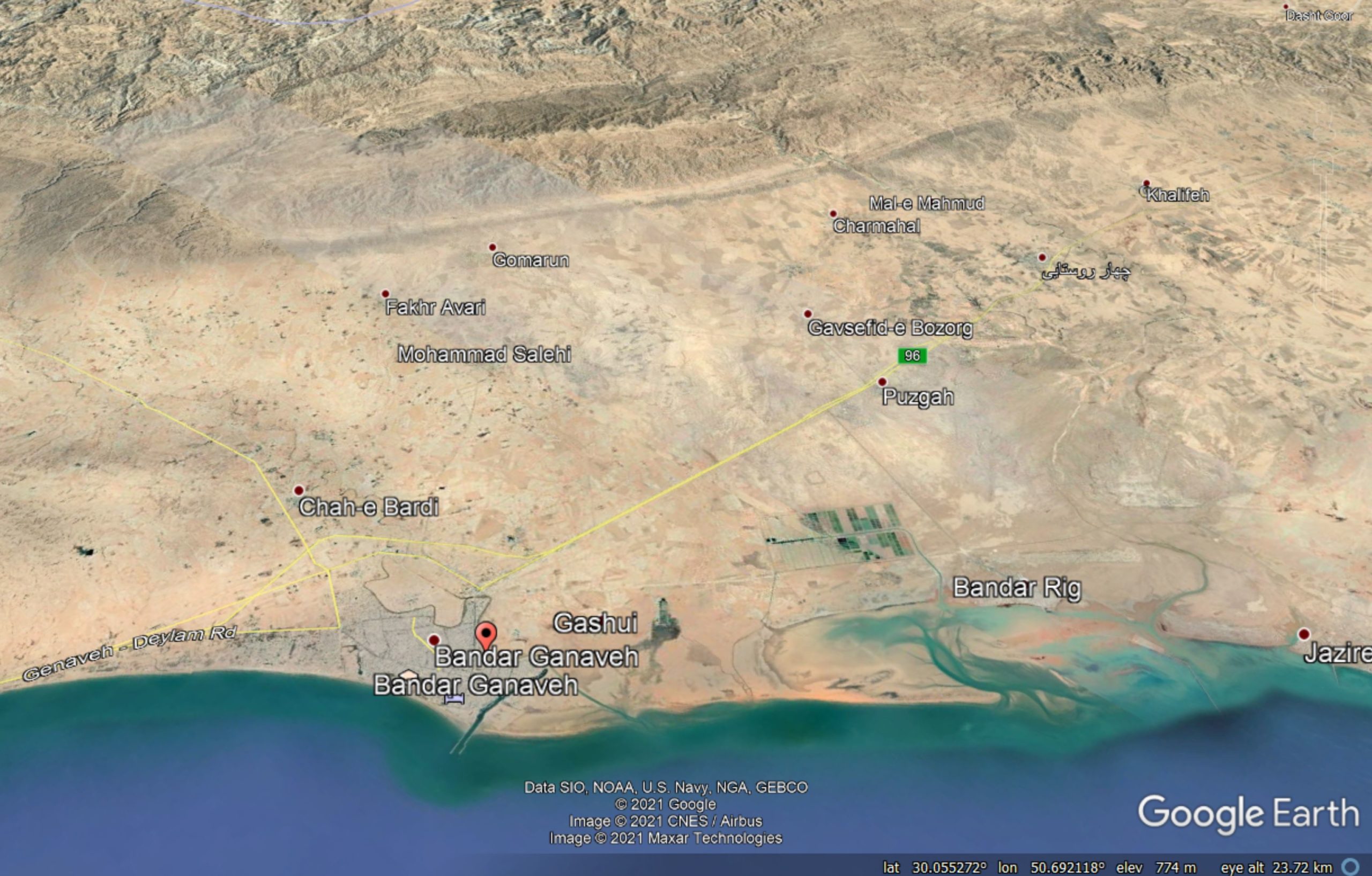
Google Earth image of the topography of the area inland of Bandah Genaveh, site of the 18 April 2021 earthquake.
.
It appears that the landslides have been triggered from this escarpment.
The video is very dramatic, but for the most part these are likely to have been shallow slides of quite low volume. The very arid conditions means that such slides generate very large quantities of dust, which looks dramatic in the videos. Nonetheless, it is likely that coseismic landslides are an important part of the erosive processes in this area.
There are other videos of this event on Youtube. One of them presents a compendium of events, although I am not sure whether they are all from this earthquake. It includes a sequence that includes this still:-
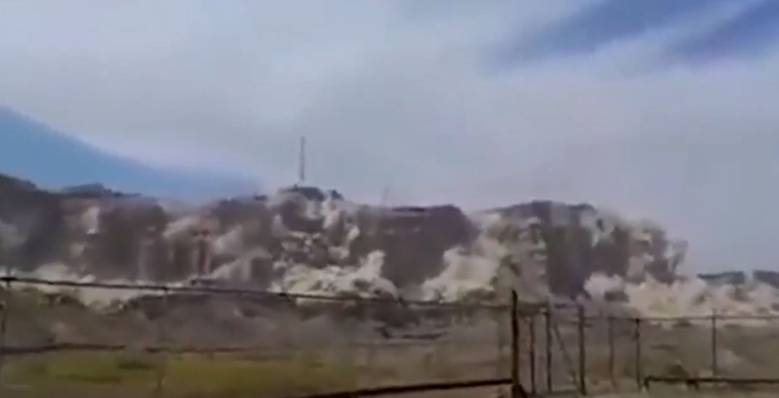
The landslides close of Bandah Genaveh in Iran on 18 April 2021. Still from a video posted to Youtube.
.
The image above does appear to be the same event as that posted in the first video, but providing a much closer view of the landslides.
An analogy for this event is probably the 2010 M=7.2 Sierra Cucupah earthquake in Mexico, which also triggered landslides in an arid mountain chain. Led by my former post-doc John Barlow, we investigated the landslides from that event. There is a description in Barlow et al. (2014).
.
Reference and acknowledgement
Many thanks to loyal reader Andrew Noad, who kindly highlighted these videos to me.
Barlow, J., Barisin, I., Rosser, N., Petley, D., Densmore, A. and Wright, T. 2014. Seismically-induced mass movements and volumetric fluxes resulting from the 2010 Mw = 7.2 earthquake in the Sierra Cucapah, Mexico, Geomorphology, 230, 138-145. http://dx.doi.org/10.1016/j.geomorph.2014.11.012.
15 April 2021
Changing rainfall patterns in the Indian monsoon with future warming
Changing rainfall patterns in the Indian monsoon with future warming
The global landslide hotspot lies is located in South Asia, driven by the summer (SW) monsoon. The monsoon drives a period of intense and prolonged rainfall in the period centred on June to September. Rainfall levels can be high – in some cases the highest in the world. The monsoon also drives convective activity that can cause cloudbursts. Together, these effects trigger large numbers of landslides, with catastrophic outcomes.
Thus, one of the key elements in the understanding of future landslide patterns is to understand the dynamics of the monsoon with climate change – i.e. under future warming. If the monsoon is likely to intensify then we might see more landslides through time. And of course vice versa. The pattern is not simple of course; the monsoon could weaken but rainfall intensity could increase. So understanding the dynamics of the monsoon is key.
A new open access paper has just been published in the journal Earth System Dynamics (Katzenberger et al. 2021) that examines the dynamics of the Indian monsoon under future warming scenarios. To do so it examines the 32 global climate models within the Coupled Model Intercomparison Project Phase 5 (CMIP5) under a range of emission scenarios.
The results are really interesting. As the authors put it:
All of these models show a substantial increase in June-to-September (JJAS) mean rainfall under unabated climate change (SSP5-8.5) and most do also for the other three Shared Socioeconomic Pathways analyzed (SSP1-2.6, SSP2-4.5, SSP3-7.0). Moreover, the simulation ensemble indicates a linear dependence of rainfall on global mean temperature with a high agreement between the models independent of the SSP if global warming is the dominant forcing of the monsoon dynamics as it is in the 21st century; the multi-model mean for JJAS projects an increase of 0.33 mm d−1 and 5.3 % per kelvin of global warming.
These are fascinating results. Under most likely scenarios for future warming the monsoon will strength, with more rainfall on average. In graphical form the figure below displays the outcomes:
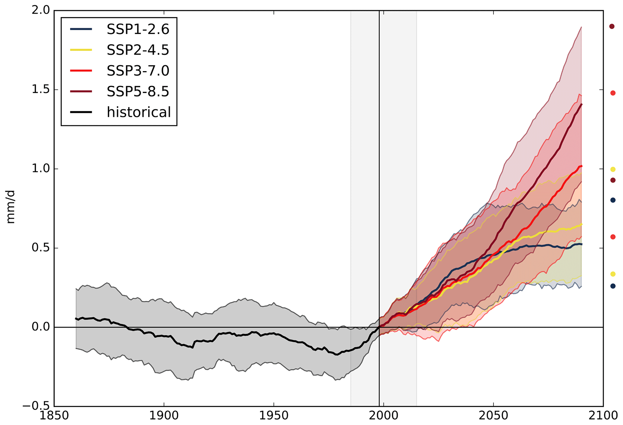
Multi-model mean of Indian summer monsoon rainfall (mm d−1) for the Indian summer monsoon for 1860–2090 relative to the mean (horizontal black line) in 1985–2015 (grey background) for the four scenarios (SSP1-2.6, SSP2-4.5, SSP3-7.0 and SSP5-8.5). The 20-year smoothed time series of one ensemble member per model was used to calculate the multi-model mean. Shading in the time series represents the range of mean plus/minus 1 standard deviation marked with circles on the right side of the figure. Image and caption (lightly edited) from Katzenberger et al. (2021).
.
Interestingly, the models project that both the west coast of India and the Himalaya region will show substantial increases in monsoon precipitation. These are the areas most affected by landslides. The models also suggest greater interannual variability, indicating that some years will be exceptionally wet.
Studies like this provide a general expectation for future behaviour. There will be nuances of course that require further investigation, such as the impacts on cloudburst rainfall and the interaction between the atmosphere and the topography. But in general terms, the models suggest that we might expect to see increased landslide activity driven by the summer monsoon with time. Coupled with the ongoing environmental degradation in the Himalayas, especially through haphazard road construction, the picture for future landslide impacts is poor. Strategies to adapt to future warming are urgently required.
.
Reference
14 April 2021
A lucky escape for a small dog, a Jack Russell Terrier, caught in a rockfall in North Yorkshire
A lucky escape for a small dog, a Jack Russell Terrier, caught in a rockfall in North Yorkshire
The RNLI, the UK lifeboat service, has a great story about an exceptionally lucky escape for a small dog, a Jack Russell terrier. On Friday 9 April 2021 a man was reported missing on the coast near to Skinningrove on the North Yorkshire Coast. The man had been searching for his missing dog. Fortunately he was found and safely recovered by the RNLI.
The dog remained missing over the weekend. On Monday 12 April one of the RNLI volunteers, Ed Thomas, was walking his own dog close to where the man was found. He heard barking and discovered the missing dog buried beneath a rockfall. The dog was trapped by its rear legs:
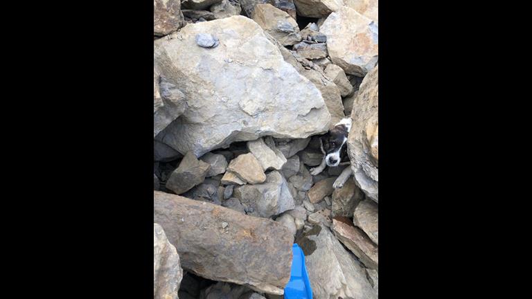
The missing Jack Russell Terrier recovered from beneath a rockfall in Skinningrove, North Yorkshire on 12 April 2021. Image from RNLI/Redcar.
.
Together with three other people, Ed was able to move the rocks to free the Jack Russell Terrier. The owners were contacted, the dog was checked out by a vet, and then taken home. The good news is that the dog was not seriously injured, and is now recovering.
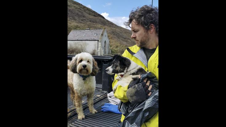
The missing Jack Russell Terrier and his rescuer from the RNLI. The dog was recovered from beneath a rockfall in Skinningrove, North Yorkshire on 12 April 2021. Image from RNLI/Redcar.
.
The odds were stacked against this small dog. As I have noted previously, the survival rate for anyone caught in a landslide is very low. The size of the blocks in the image above demonstrates this clearly. The weather conditions over the weekend were not good, with temperatures below zero and even snow at times (quite unusual for the UK in April). There were strong winds at times, so conditions on the coast would have been brutal. This coast has a high tidal range, meaning that the chance of drowning was significant. And finally, the dog needed someone to hear a bark.
12 April 2021
The interesting morphology of the Culluchaca landslide in Peru
The interesting morphology of the Culluchaca landslide in Peru
After posting yesterday about the Culluchaca landslide in Peru, I spent some time looking at the morphology of the site using the Google Earth Imagery. As a reminder, this is what the Google Earth images show. The image was collected in July 2019:-
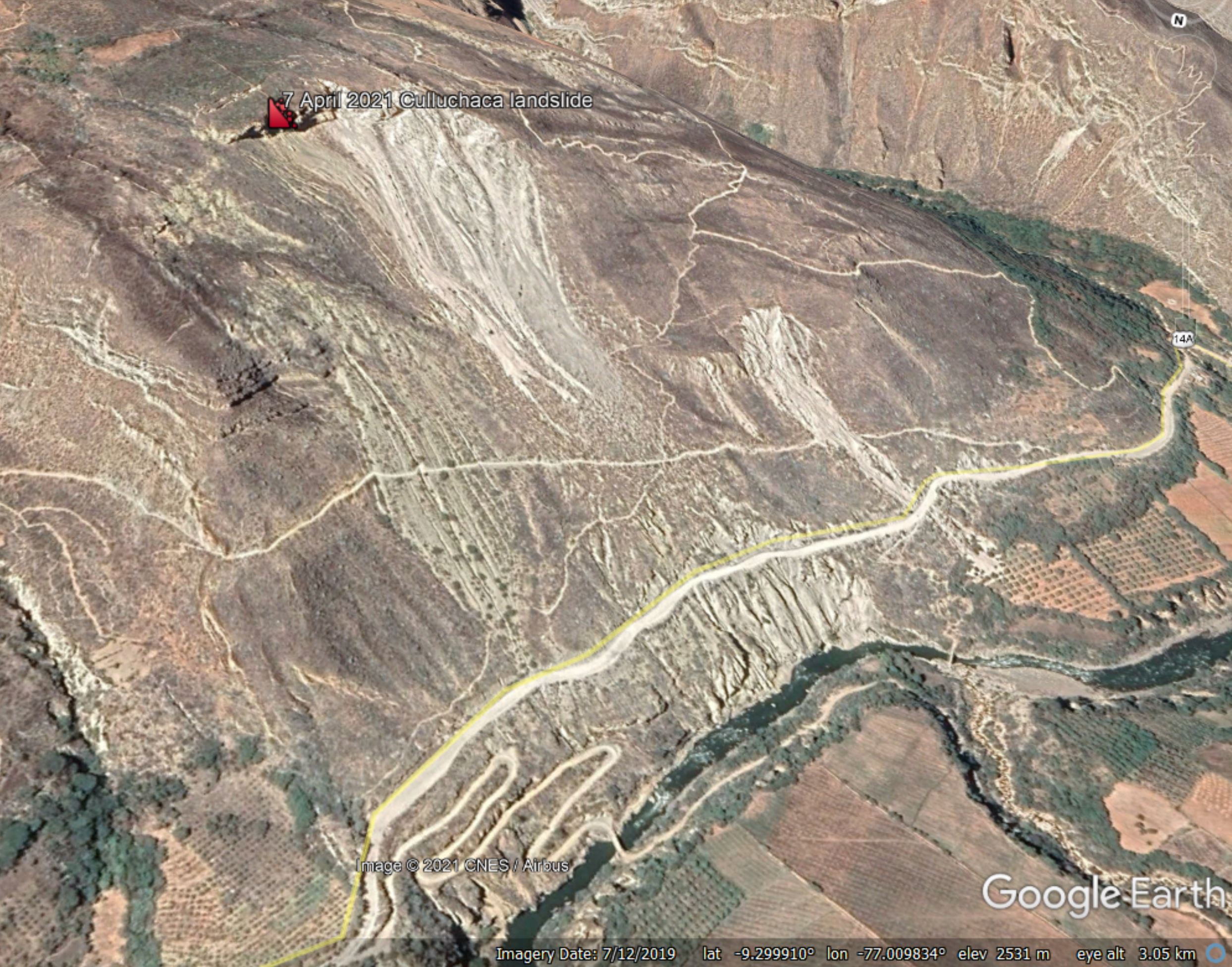
Google Earth view of the site of the landslide close to Culluchaca in Peru.
.
The interesting features of this landslide lie above the crest of the slide shown above. The image below shows that area, on this occasion looking square onto the landslide:-
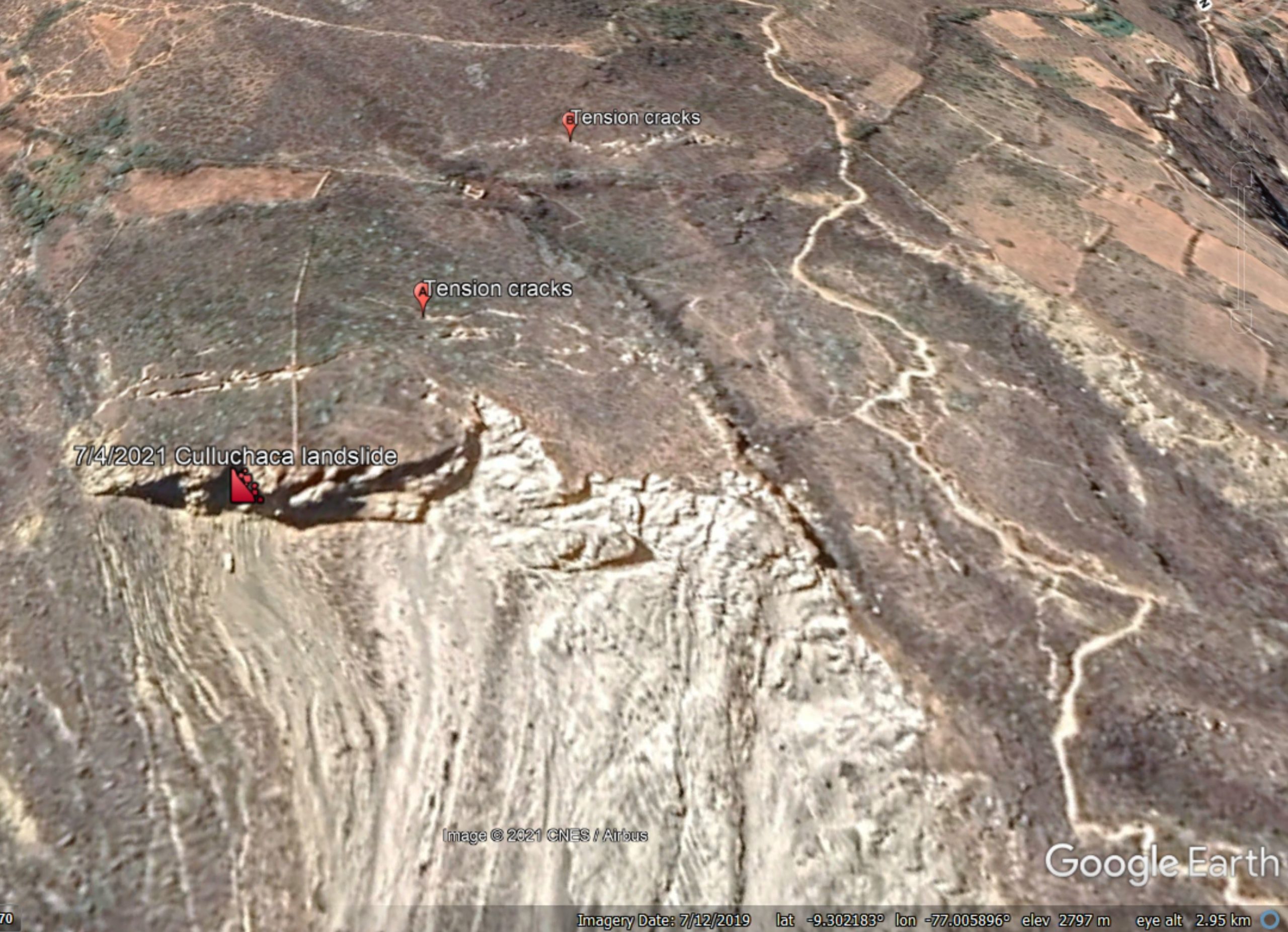
Google Earth view of the crest of the landslide close to Culluchaca in Peru.
.
The image appears to show two arrays of tension cracks. The first set, marked with A, are about 50 metres back from the landslide crown. But there is another set, marked with B, that are probably less well developed. These are about 150 metres back from the landslide crown, indicating a very large instability.
Perhaps even more interesting is the set of features further across the slope. The image below shows the morphology of this area. I’ve left the other markers in place for reference:-
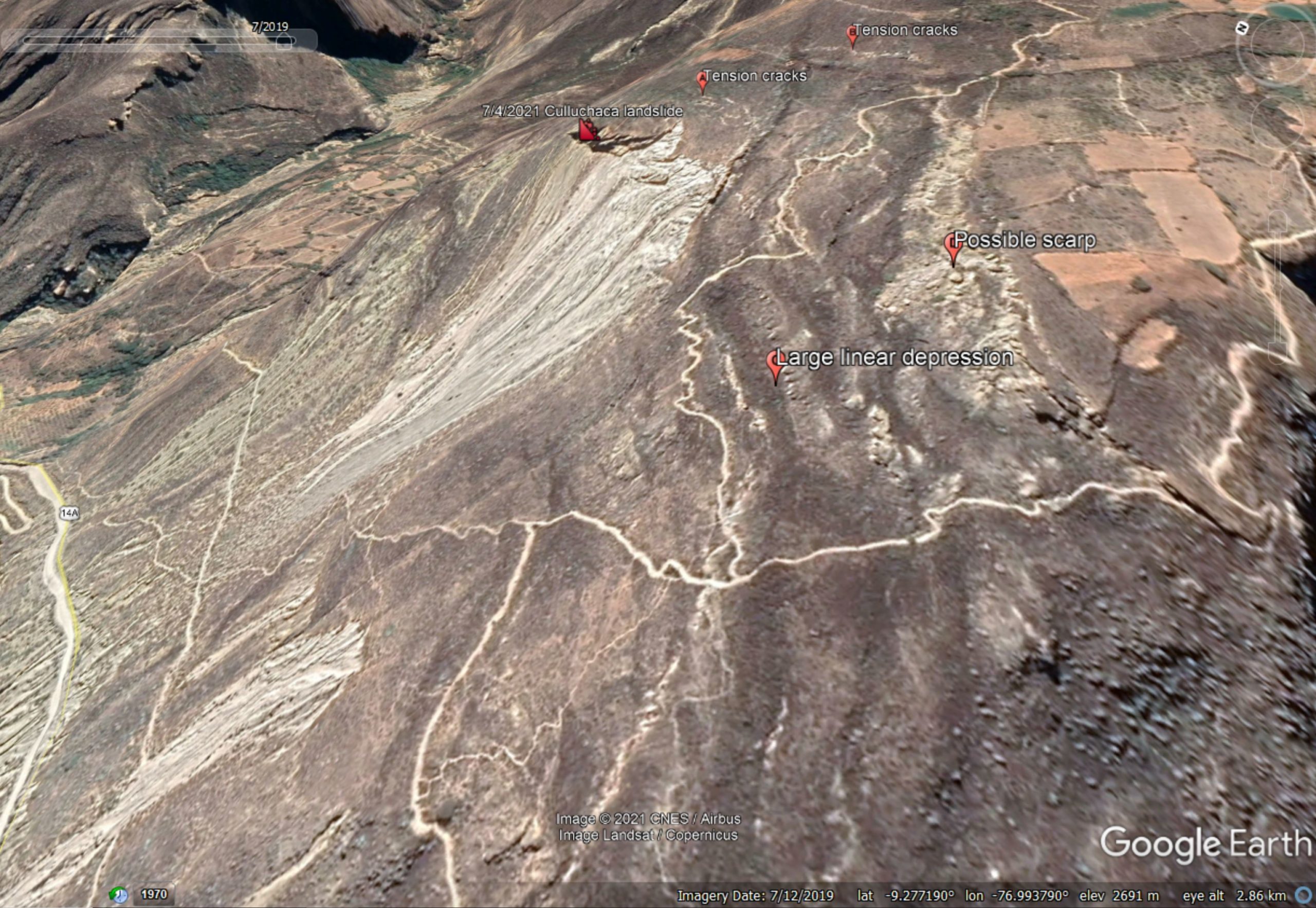
Google Earth view of features at the crest of the landslide close to Culluchaca in Peru.
.
Running across the slope parallel to the crest is an array of linear depressions, some of which are large and extensive. Upslope from here is a ridge with extensive bouldery deposits, which is probably a scarp.
The most likely explanation for these features at that this is the site of a deep-seated gravitational deformation (DSGD), defined as “a gravity-induced process affecting large portions of slopes evolving over very long periods of time. A DGSD may displace rock volumes of up to hundreds of millions of cubic meters, with thicknesses of up to a few hundred meters.”
DSDGs are very large, slow creeping failures in rock masses, common in high mountain areas. I wrote about an example in Italy in 2019. They typically generate arrays of parallel scarps and troughs high up on the hillside.
Thus, the failure of the Culluchaca landslide on 7 April 2021 is probably only a small part of the unstable mass on this slope. However, that does not necessarily mean that further collapses are likely in the short term – DSGDs creep for hundreds and even thousands of years.
I should note that an alternative explanation for these features in this landscape as an active fault. This possibility cannot be precluded without further investigation.
11 April 2021
Culluchaca: a large landslide on 7 April 2021 in Peru
Culluchaca: a large landslide on 7 April 2021 in Peru
On 7 April 2021 a large failure occurred close to the village of Culluchaca in Huari province of the Áncash region of Peru. The landslide did not claim any lives but caused serious damage to about 1 km of National Road 14a:-
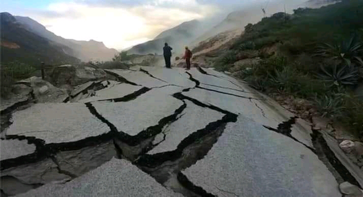
The aftermath of the landslide close to Culluchaca in Peru. Still from a video posted to Youtube.
.
The location of the landslide appears to be -9.301534° -77.008174°. This is a Google Earth oblique view of the site:
Google Earth view of the site of the landslide close to Culluchaca in Peru.
.
The image shows an existing large failure at this site. Note also the very clear tension cracks located above the existing crest of the landslide. I suspect that a large block delineated by these cracks has failed. The image below shows the aftermath of the landslide:-
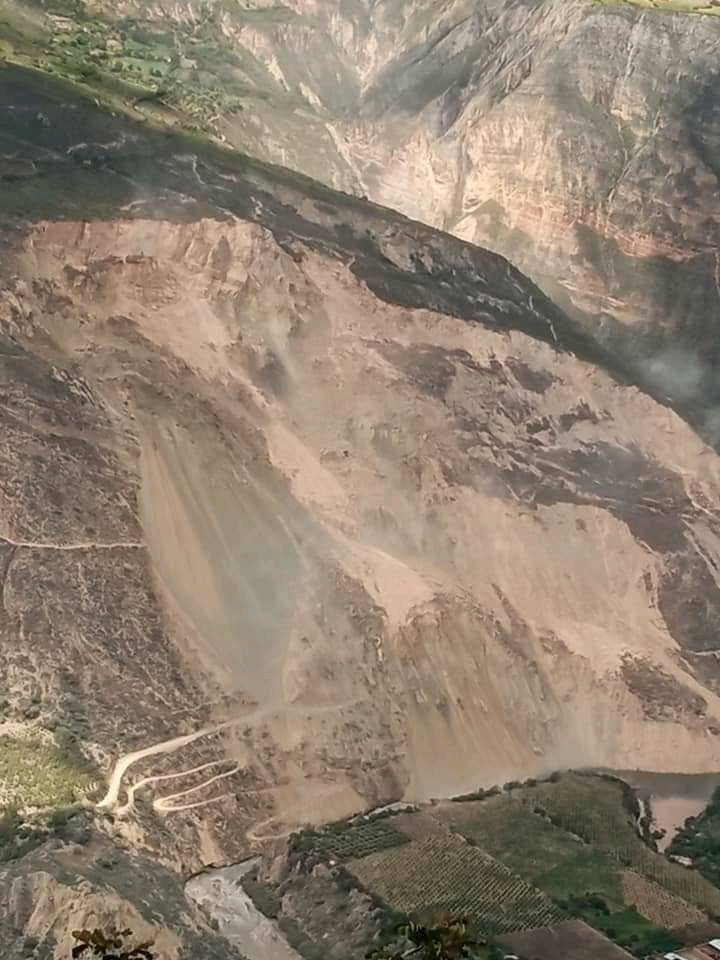
The aftermath of the landslide close to Culluchaca in Peru. Image from Áncash Noticias.
.
Note the very extensive scale of the landslide in the image above. It is clear that a large volume has failed.
According to a news report in Áncash Noticias (in Spanish), the population of the village of Culluchaca have had to be evacuated because of the risk. In addition the landslide has disrupted the electricity network supply the districts of Huacachi, Anra, Uco, Rapayán, Paucas and Huacchis in the province of Huari, and some parts of the province of Antonio Raimondi and Huamalies.
There is a video that captures some of the failure and the aftermath on Youtube:-
.
Clearly reinstatement of the road will be important, but this will not be possible until the landslide has stabilised again. It will not be a straightforward problem to solve. Fortunately the images above suggest that the river is probably not blocked by the landslide, at present at least.
9 April 2021
Oxley Highway: multiple landslides in New South Wales, Australia
Oxley Highway: multiple landslides in New South Wales, Australia
The Oxley Highway is a rural road orientated east-west in New South Wales, Australia. To the west is the town of Nevertire, to the east it terminates at Port Macquarie on the Tasman Sea coast.
Heavy rainfall in March triggered multiple landslides along the Oxley Highway in a section between Yarras and Walcha. This is the landscape of the section in question:-
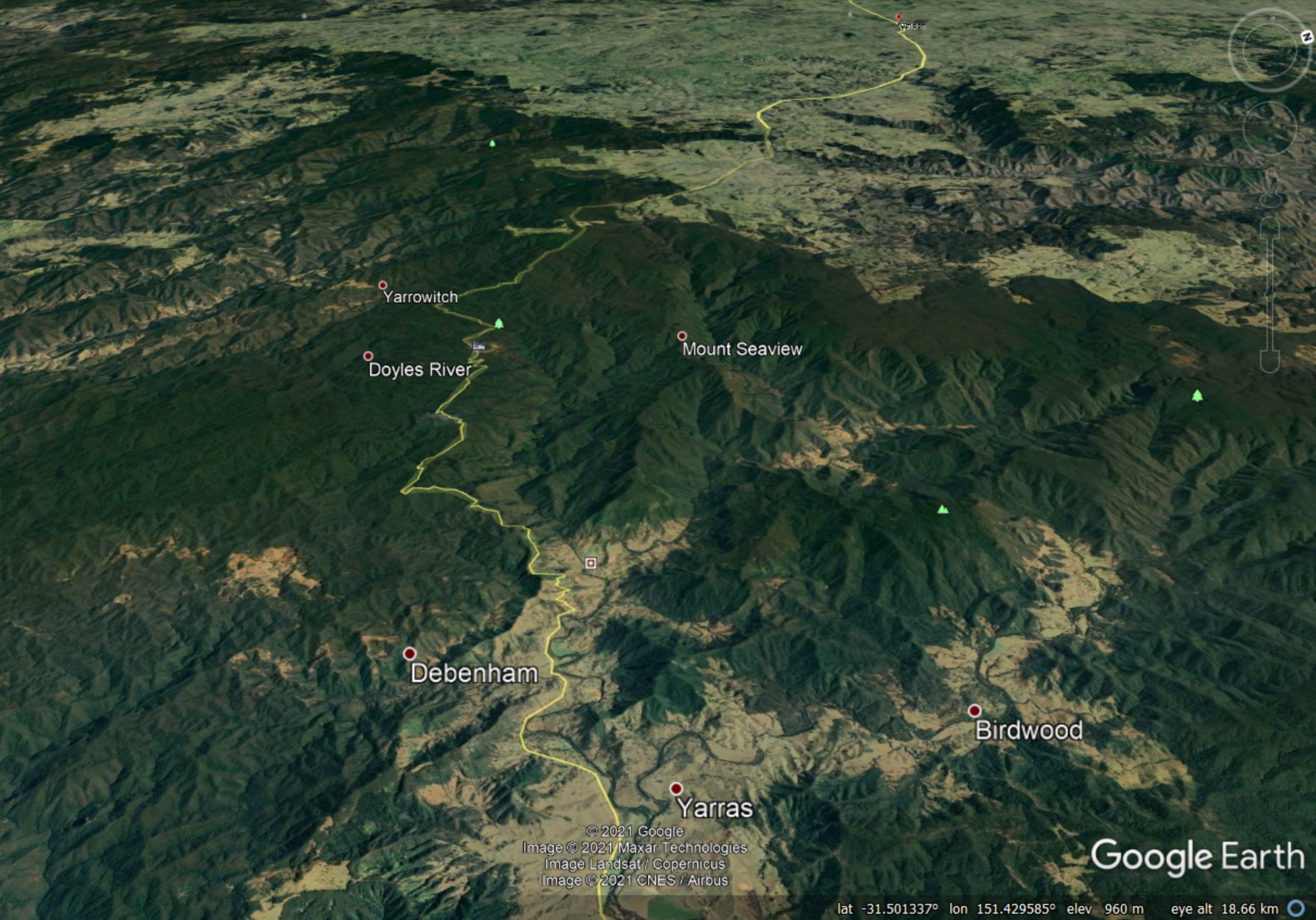
Google Earth image showing the landscape along the Oxley Highway between Yarras and Walcha (just visible in the distance) in New South Wales, Australia
.
There is a good helicopter reconnaissance video showing the magnitude of the damage caused by landslides to the highway, posted to Youtube:-
.
The level of damage is also clear in some of the images released by Transport for NSW:-
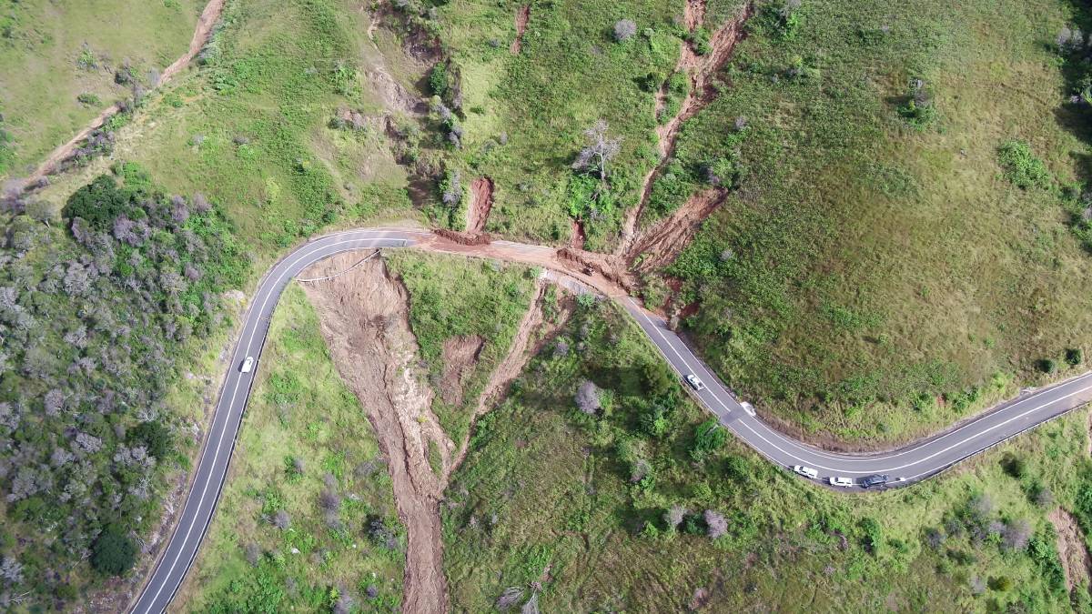
Landslide damage along the Oxley Highway. Image from Transport for NSW.
.
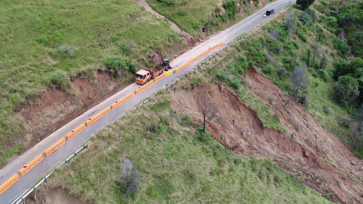
A landslide on the Oxley Highway. Image from Transport for NSW.
.
There are more than 70 landslide sites along the road. Transport for NSW has estimated that it will at least two months before the road can reopen with a limited service, and several more months at least before the problems are fully mitigated. As the two images directly above show, some of the landslides are both large and located below the level of the road bench. Remediating these sites will be a substantial and expensive challenge.
Meanwhile, also in Australia, 7 Daily News tweeted a video yesterday of a coastal landslide in Queensland:
Another sinkhole has opened up at Inskip Point, stripping chunks of sand away from the beach. It appeared after the recent deluge near where vehicles are loaded onto the barges to go to Fraser Island. Vid: Wayne Kerr. https://t.co/dSgFbiE9NM #7NEWS pic.twitter.com/7zmXEc5dhk
— 7NEWS Sunshine Coast (@7NewsSC) April 8, 2021
.
I have posted about these retrogressive landslides at Inskip Point previously. This is another example of a Retrogressive Breach Failure, not a sinkhole.
8 April 2021
InSAR as a wide area landslide detection tool
InSAR as a wide area landslide detection tool
The development of Satellite Inferometry (InSAR) in the last two decades has provided a new tool for the detection of landslide movements. In general the application has been to specific settings – montoring the movement of a known landslide or of mine waste for example. Sometimes InSAR is used for near real time monitoring, on other occasions it has been applied to look at the development of a failure that has already happened. The tool is new and quite experimental, but it is making the transition to practise.
One of the potential opportunities for InSAR is to be able to detect deformation over large areas. National InSAR maps are now available – the best example is in Norway. The question that this poses is whether this type of approach could be used to detect the early signs of movement of potentially hazardous but hitherto unknown failures – an obvious example being the Chamoli landslide in India earlier this year. But there are many complexities involved, some of which are quite challenging – for example, the impacts of geometric distortion and of vegetation growth, both of which might degrade the signal.
A new paper has just been published in the journal Landslides (Wang et al. 2021) that explores this approach. The authors have looked at Shuicheng County in Guizhou Province in China as an example. This area is interesting as located within it is the Jicangzhen landslide, which killed around 45 people on 22 July 2019.
The authors found that after analysis the InSAR technique allowed them to identify six large, actively deforming landslides. In these cases they were able to extract a time series of movement of the slope, suggesting that the technique is potentially applicable as an early warning system, as the image below, from the paper, shows:
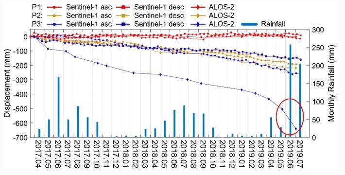
Time series data for three of the landslides in the study area, from Wang et al. (2021). The Jichangzhen landslide is point P1.
However, interestingly, no precursory deformation was detected for the Jicangzhen landslide itself (the red lines on the graph above). In this case the technique would have been of no use. But, the authors point out that this landslide was triggered by short duration, heavy rainfall and possibly by human activity:
Considering the meteorological conditions and optical satellite images at that time, we conclude that short-term heavy rainfalls triggered the Jichangzhen landslide, as well as the road construction or maintenance may change the slope stability.
The image below, from Wang et al. (2021), provides an aerial view of the Jicangzhen landslide. At the top of the slope is a road – note that the authors have identified the source area as being located above that highway. At the time of the event I suggested that this landslide might have been triggered by a smaller failure in the upper reaches of the slope. The InSAR data appears to strengthen the argument that in this case the slope was destabilised by slope cutting for the road, and then triggered by exceptional rainfall. The debris loaded the slope below the road, generating a massive failure.
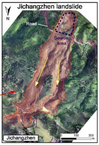
Aerial image of the Jichangzhen landslide in China, from Wang et al. (2021).
.
In cases like this there is unlikely to be precursory deformation, such that InSAR is unlikely to work. Thus, the paper provides a really elegant illustration of both the potential of the technique and its likely limitations.
.
Reference
Wang, Y., Liu, D., Dong, J. et al. 2021. On the applicability of satellite SAR interferometry to landslide hazards detection in hilly areas: a case study of Shuicheng, Guizhou in Southwest China. Landslides. https://doi.org/10.1007/s10346-021-01648-y
7 April 2021
The complex politics of managing coal waste tip stability in South Wales
The complex politics of managing coal waste tip stability in South Wales
The valleys of South Wales have one of the most complex landslide settings in the UK. It is a landscape that has a great deal of natural instability, much of it relict. However, many slopes continue to move, sometimes causing substantial levels of disruption. On top of this is imprinted the effects of decades of coal extraction, which led to increased instability. In some cases existing landslides were reactivated. And finally, and most significantly, poor coal waste management practises led to the creation of thousands of spoil tips, some of which had substantial stability problems. The worst example is of course the appalling 1966 Aberfan disaster, but that case was just one of many spoil tip landslides.
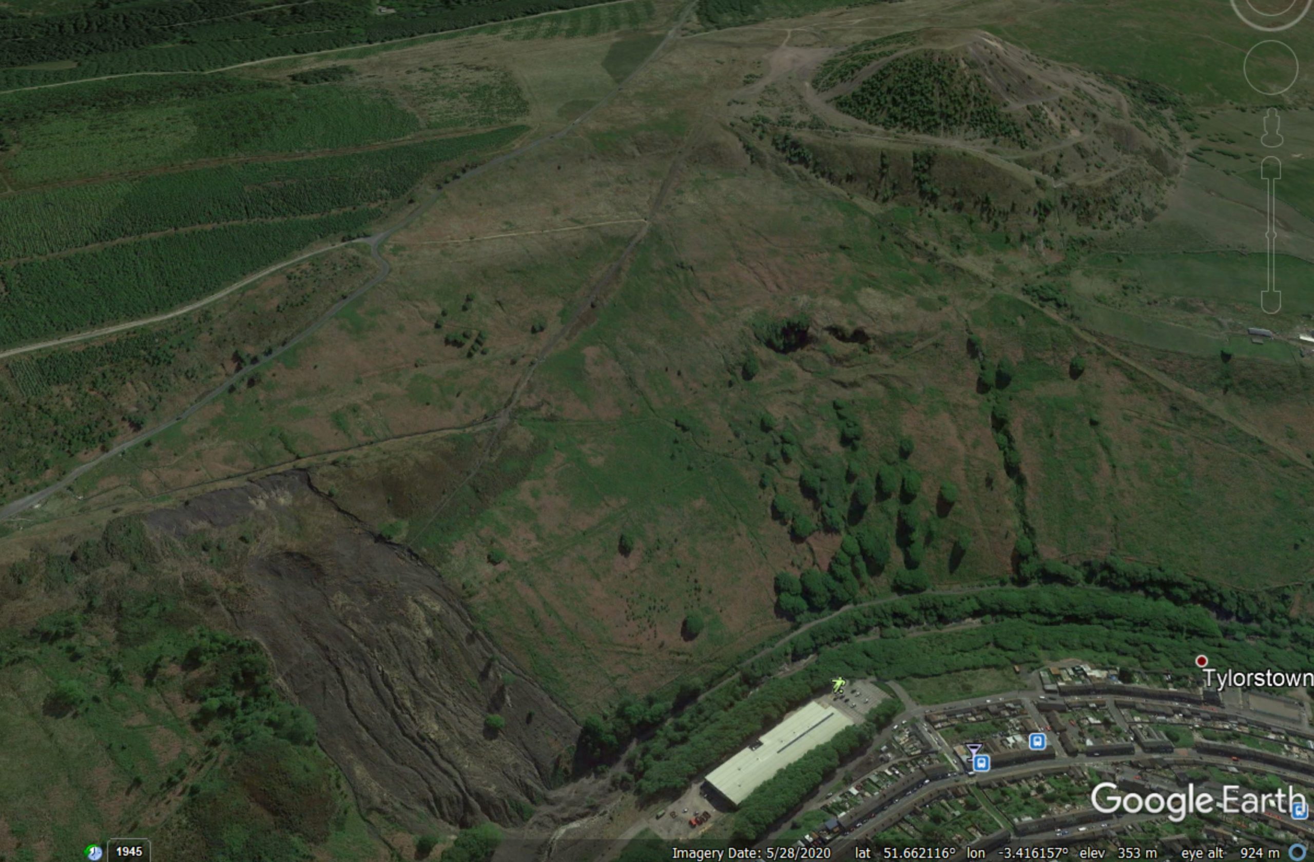
Google Earth image of the coal waste tips at Tylorstown in South Wales. Note the large conical tip at the top of the hill and the failed tip in the lower left corner.
Coal mining has now ceased, and many of the most dangerous spoil tips have been removed. However, the landscape remains dotted with many legacy waste piles, often located high on the valley walls. These have been mostly stable in recent decades, but in February 2020 it became clear that the beast was waking from its slumbers. Heavy rainfall triggered a large failure in a coal spoil tip at Tylorstown. And then in December a further failure occurred at Wattstown.
It is now recognised that there is a major problem. There are thought to be about 2,100 spoil tips left in the valleys of South Wales. Around 300 of these are considered to be high risk. Perhaps surprisingly, only 40 of these are managed by the Coal Authority, the governmental nod with responsibility for (amongst other things) the management of historic liability issues, including polluted water, subsidence and surface hazards associated with past mining activity. The remainder are owned by a range of bodies, including local authorities. Perhaps surprisingly, the majority are privately owned.
The FT has a really good article about the complex politics that surround the management of the coal waste tip stability hazard. It notes that the likely financial cost of dealing with the hazard is very substantial – the Tylorstown tip alone might cost £10 million to remediate. The total bill might be in the order of £500 million – and experience tells us that these costs tend to balloon once the work commences.
Until recently the UK Government position has been that this is a problem for the Welsh Government, but the scale of the threat means that it is likely to be beyond its means. Cash strapped local authorities and private land owners will not have the resources. The article notes that there is a strong argument that the coal was mined in the national interest, such that the costs should be carried by the whole of the United Kingdom.
Strangely, the slow motion horror show that is Brexit may play a key role in how this plays out. In Scotland, Brexit has turbocharged the move towards independence, threatening the historic union. This is now spilling over to Wales, where the profile of independence is rising. Boris Johnson is the Prime Minister from the Conservative and Unionist Party; the gathering momentum for independence is not a good look. So, the article speculates, the UK Government might have to step in to cover the costs of mitigating the spoil tip hazard as a sweetener to the electorate in Wales.
Landslide hazard is often viewed as a physical process, managed through good engineering geology and high quality engineering. The reality is that the scale of the threat means that politics is often at least as important of engineering. In the case of South Wales, the complex politics might be the key that unlocks the funding needed to manage the threats posed by the coal waste tips.
6 April 2021
Mount Lewotolok and Adonara island: up to 168 people killed by lahars and debris flows in Indonesia
Mount Lewotolok and Adonara island: up to 168 people killed by lahars and debris flows in Indonesia
Very heavy rainfall in Indonesia over the weekend triggered two major landslides, both of which had multiple casualties. Information about the two remains quite patchy at present, but there is a good report on the MENAFN website. One of the events was a lahar from the flanks of Mount Lewotolok, located on Lembata island in in East Nusa Tenggara province. The reports indicate that 18 people are known to have died, and a further 62 people are missing. The MENAFN report states that:-
At least 18 people were killed and 62 missing after their villages were hit by cold mudflows from a volcano on Indonesia’s Lembata island, an official said on Monday. Volcanic debris from Mount Lewotolok engulfed homes on Sunday following heavy rain, Thomas Ola, the head of Lembata district in East Nusa Tenggara province, told dpa news agency
AP has this image of the aftermath of a part of the landslide:-
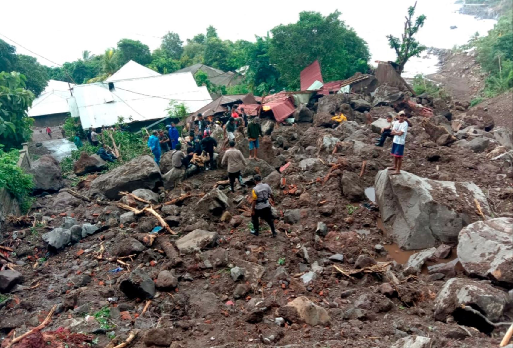
The aftermath of the lahar from Mount Lewotolok in Indonesia. Image from AP.
.
Reports suggest that this landslide struck a village in Ile Ape Timur on the flanks of Mount Lewotolok.
Meanwhile, there are also reports of a significant debris flow on Adonara island, also in East Nusa Tenggara province. Reports suggest that there are 69 known fatalities from this event, with a further 19 missing with rescue operations still underway. It appears that the debris flows, which have in some cases been described as flash floods, struck the village of Nele Lamadike and surrounding areas. It is not clear to me as to where on Adonara island this event was located, but there is at least one volcano on the island, suggesting that this could also have been a lahar.
Given the remote location of these islands, it is difficult to obtain accurate information about the losses and indeed the nature of the events. Satellite images might provide some help when the skies clear.
5 April 2021
Neustift in Austria: boulder vs house, the boulder won
Neustift in Austria: boulder vs house, the boulder won
In Neustift in Austria, a 4 metre high boulder struck a house on 2 April 2021 having detached from an adjacent slope. This image below, from Tyrol ORF, gives an idea of the scale of the event:-
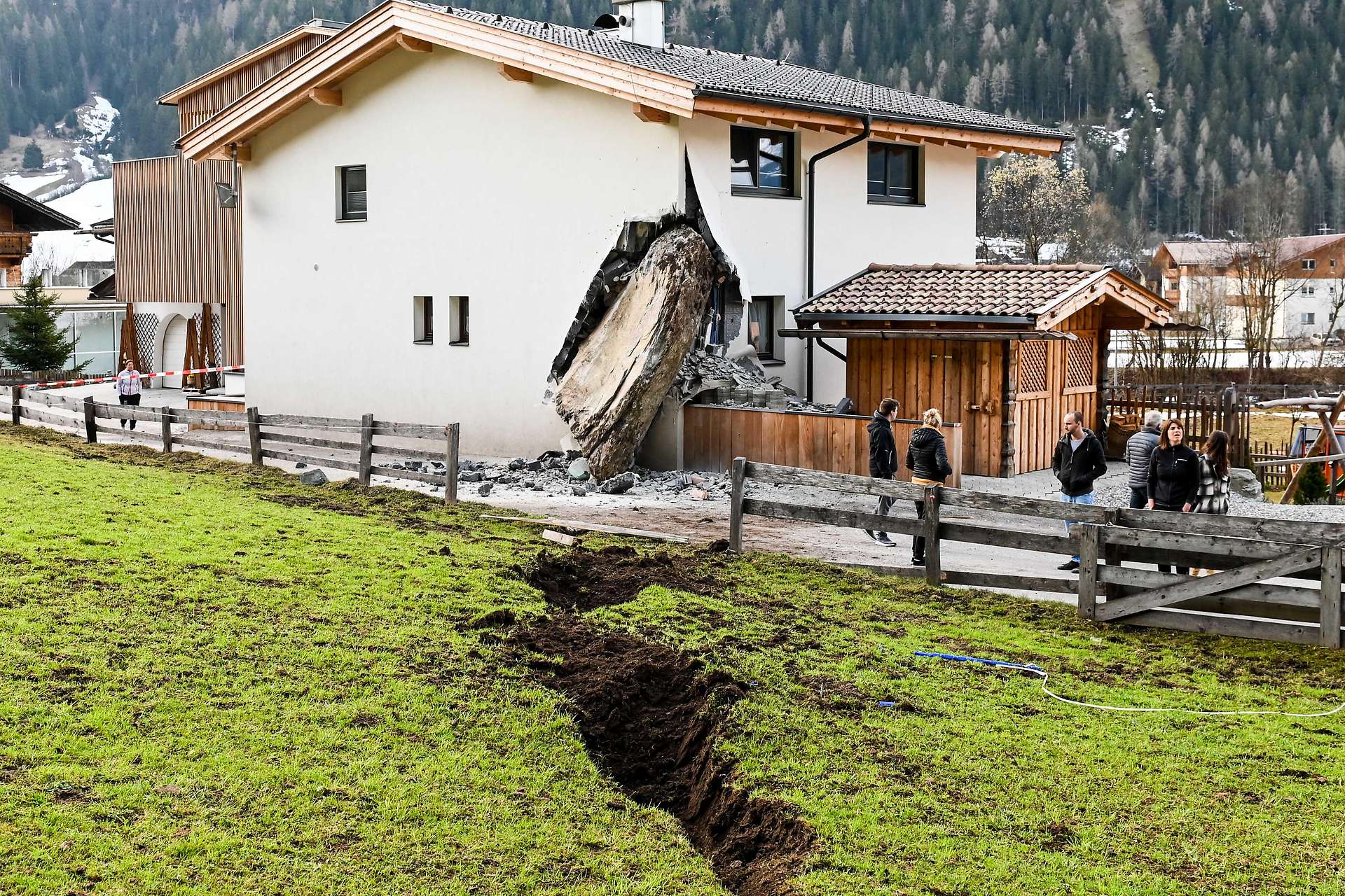
The boulder that struck a house in Neustift in Austria. Image from Tyrol ORF.
.
The image below, also from Tyrol ORF, shows the track of the boulder prior to striking the house:-
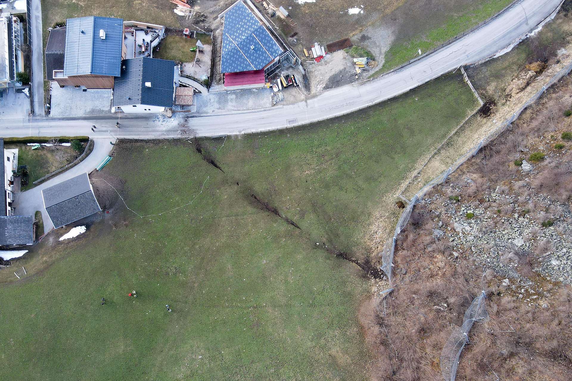
The track of the boulder that struck a house in Neustift in Austria. Image from Tyrol ORF.
.
Note that the boulder has crashed through two flexible rockfall barriers:-
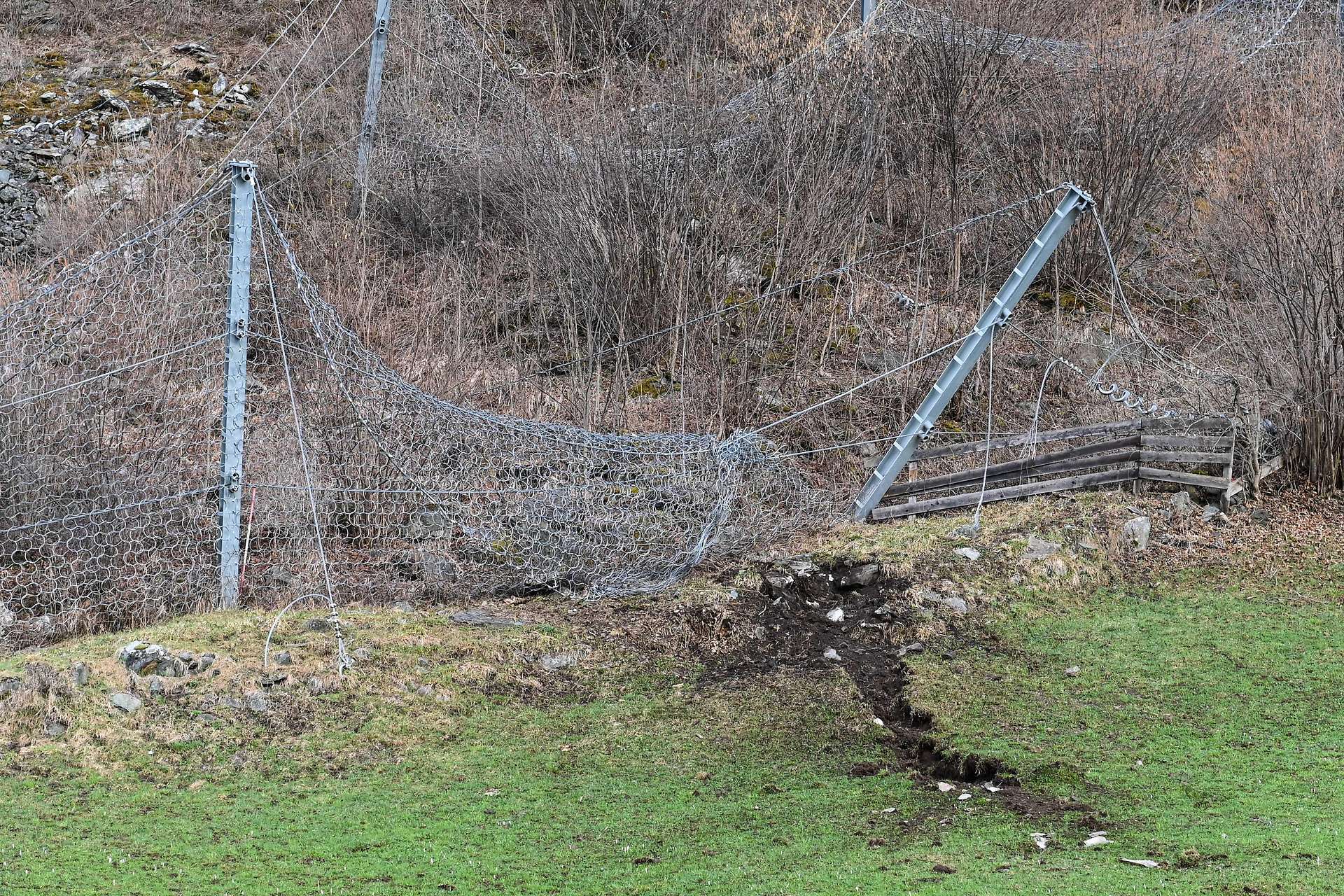
Destroyed flexible barriers along the track of the boulder that struck a house in Neustift in Austria. Image from Tyrol ORF.
.
Clearly, barriers on this scale were not designed to catch a boulder of the scale of the one that struck the house. Fortunately there were no casualties in this event.
The boulder has a very strong tabular shape (like a very large, flattened pebble of the type that you could skim on flat water). The track, and the orientation of the boulder in the house, suggest that the rock was rotating along its short axis, much like a wheel. It also appears that the boulder was losing contact with the surface at times (see the second image), thus rolling and bouncing down the slope. If a tabular boulder gets into this configuration of movement it is both stable and highly mobile, allowing the long runout across the field before striking the house.
The adjacent properties have been temporarily evacuated whilst a 3 m high berm is being built to provide short term protection. The house in Neustift that was struck by the boulder will need extensive reconstruction:-
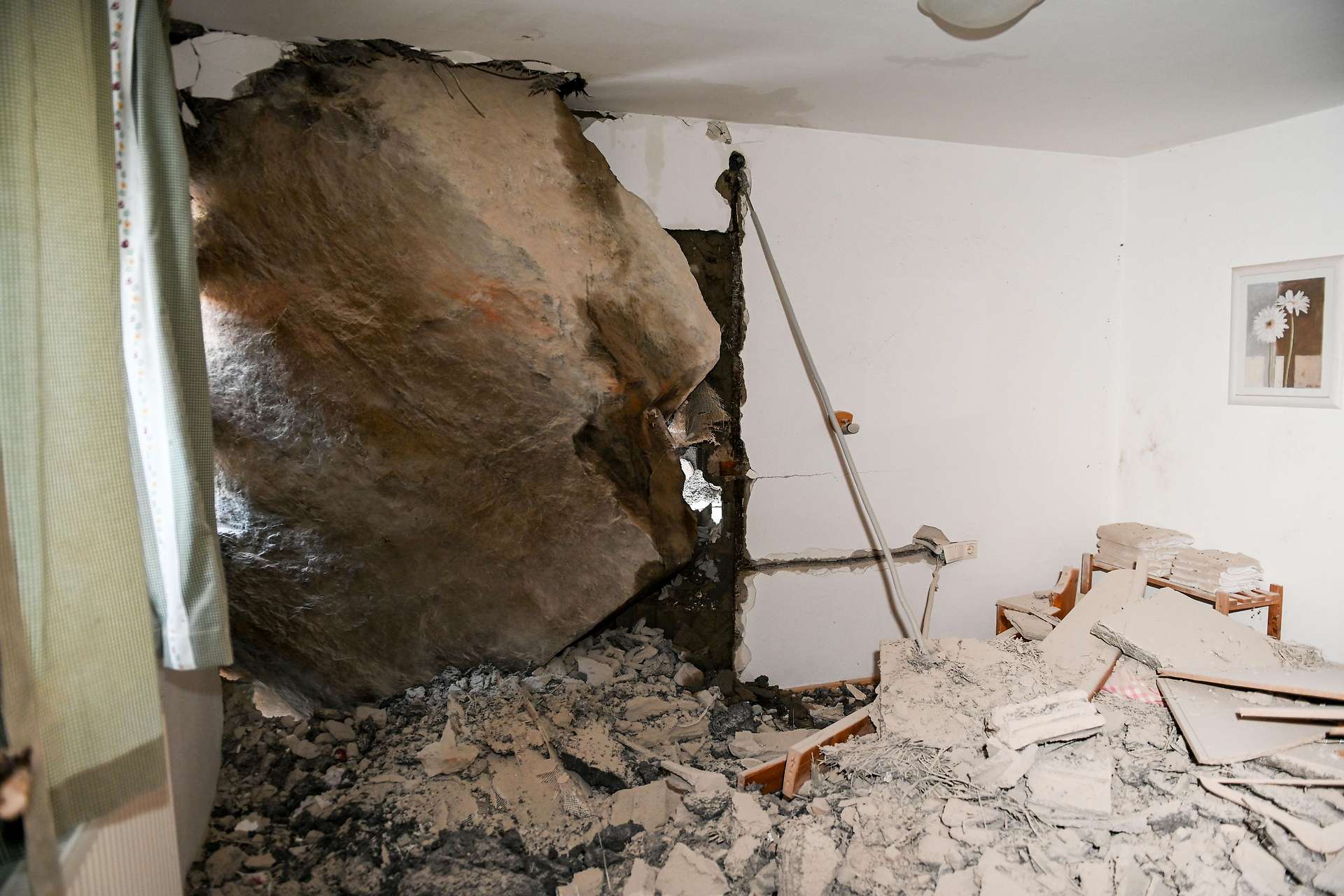
The interior of the house struck by the boulder in Neustift in Austria. Image from Tyrol ORF.
.
The simple necessity of removing the boulder is going to be a challenge given both the scale of the rock and the likelihood of significant structural damage to the corner of the property.
This is the latest of several of these events in recent years. I’m reminded of Rocky, the famous boulder from the 2011 Christchurch earthquakes.
 Dave Petley is the Vice-Chancellor of the University of Hull in the United Kingdom. His blog provides commentary and analysis of landslide events occurring worldwide, including the landslides themselves, latest research, and conferences and meetings.
Recent Comments