
29 September 2015
The Inskip sinkhole in Australia – undoubtedly a landslide
Posted by Dave Petley
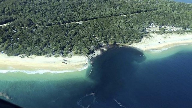
The Inskip Sinkhole
The Inskip Sinkhole, as described in various media reports, developed on the Inskip Peninsular at MV Beagle Point, north of Rainbow Beach, on Saturday night:-
.
Descriptions of the event sound quite exciting, with a caravan, a trailer a car and some tents disappearing into the sea. Fortunately there was no loss of life. The best gallery of images of the aftermath can be found on the Sunshine Daily Coast website, from which this image is taken:
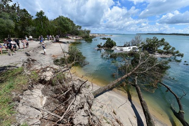
Inskip Sinkhole from the Sunshine Coast Daily
.
In the last couple of days the media have realised that this is not in fact a sinkhole, but is undoubtedly a submarine landslide. This report gets it right:
A Queensland Parks and Wildlife spokeswoman said the event was unlikely to be related to or caused by earthquake activity. “Rather, it’s most likely a natural phenomenon caused by the undermining of part of the shoreline by rapid tidal flow, waves and currents,” she said. “When this occurs below the waterline, the shoreline loses support and a section slides seaward, leaving a hole, the edges of which retrogress back towards the shore.”
This rather breathless report suggests that such events are not particularly uncommon on this section of coastline:
“A similar “sinkhole” event in the area was reported in 2011, and Rainbow Beach locals recalled “numerous” events.”
It would be fascinating to see some high resolution bathymetry data for this area as these slope failure events should leave a very distinctive deposit on the seabed. The above report quotes a local geologist, Ted Griffin, in explaining the phenomena:
“He said a large channel between Inskip Pt and Fraser Island regularly builds up a “shoulder” of sand, and falls away. “This is a big channel, perhaps 50 or 100 metres. It’s just a very unstable cliff of sand,” he said. “It seems to me very poor planning, that they’ve allowed development so close to such a vulnerable area.”
However, the exact mechanism of failure, and its causes, are not clear to me and would be worthy of further investigation.
 Dave Petley is the Vice-Chancellor of the University of Hull in the United Kingdom. His blog provides commentary and analysis of landslide events occurring worldwide, including the landslides themselves, latest research, and conferences and meetings.
These erosion events are relatively common on Australia’s east coast. They also occur elsewhere such as the lower Mississippi River and in the Netherlands, where they have been well researched. They are not ‘sinkholes’ (collapses of cave roofs) or underwater landslides (shear failures).
They are in fact ‘retrogressive breach failures’ (RBF) or sometimes referred to as ‘retrogressive flow slides’.
The geomechanical nature of RBF events has been comprehensively described in Beinssen, Neil and Mastbergen (2014) and is briefly summarized below. When medium to densely packed (dilatant) fine sand exists on a subaqueous slope, it is potentially unstable and vulnerable to a failure mechanism termed ‘retrogressive breach failure’ (RBF). This failure can be initiated by a small triggering event (e.g. a static liquefaction event) which creates a small scarp on the subaqueous sandy slope and which then sets a positive feedback erosion event in motion. The momentum of sand falling off the vertical face of the scarp generates a sand/water density current which flows downslope and transports entrained sand into deeper water offshore.
The vertical face of the subaqueous wall of sand (the breach) can remain dynamically stable via a geotechnical property of sand known as ‘dilation’. A shear force close to the breach, generated by the sand wall’s tendency to collapse under gravity, causes the grain structure to ‘dilate’ (the void ratio to increase). This creates an under-pressure in the pore water (relative to surrounding hydrostatic pressure) which temporally ‘sucks’ the grains together and stabilises the wall as it retrogresses upslope from its starting point.
As the breach continues upslope, its wall height will increase if the event’s runout angle is less than the slope angle of the seabed. A growing wall height will increase the momentum of the event and this will enhance scouring at the base of the wall and hence further reduce the runout angle, leading to an even greater wall height. Positive feedback (ignitive growth) increases the event’s vigor.
As the wall height grows, events usually develop into ‘dual mode failure’ where the failure mechanism switches back and forth between breaching and sliding. Dual mode greatly increases the rate of sediment release and so boosts the density current. Such events are particularly vigorous with a wall height of up to 7m and a retrogression rate of 0.8m per minute at Amity Point and Inskip Point.
After each RBF event finishes, it leaves behind a characteristic ‘amphitheatre’ shaped morphology at its upslope end including a ‘choke’ which concentrates the density current during the active phase. At its lower end, a long tongue or fan of sand is deposited downslope and offshore as the density current loses momentum and its entrained sand settles. This ‘signature’ morphology can be used to identify RBF sites after the active phase has ended and before sand infilling.
References
Beinssen K, Neil DT, Mastbergen DR (2014) Field Observations of Retrogressive Breach Failures at two Tidal Inlets in Queensland, Australia. Australian Geomechanics, 49, No. 3, 55-63.
Beinssen K. and Neil DT. (2015) “Retrogressive Breach Failure Events at Amity Point, Australia and their Interaction with Built Defences”. Proceedings of the Twenty-fifth (2015) International Ocean and Polar Engineering Conference, Kona, Big Island, Hawaii, USA, June 21-26, 2015, 1325-1330.
[Fascinating, many thanks. I think I’d argue that that this is can easily be described as a form of retrogressive landslide, but that is just a technicality. Landslides do not necessarily involve shear failure. D.]
Thank you Dr Dave. I agree that RBF events can be classified as ‘underwater landslides’. So can ‘sinkholes’ (collapses of cave roofs) which happen underwater. I guess anything which moves material downhill (coverts gravitational potential energy into kinetic energy and ultimately into heat) is a landslide. Waterfalls would also be a special case of landslide.
The interesting thing about RBF events is that they depend on the ‘shear dilatency effect’ of medium to tightly packed fine sand combined with the hydraulic behaviour of density currents which carry the entrained sand offshore.
The mechanism of these events is not well understood by geotechnical and coastal engineers in Australia. Engineers responsible for levee bank stability of the Mississippi River and particularly, engineers responsible for dike stability in the Netherlands, understand this natural phenomenon well. The recent Inskip event has been good in that it has led to debate in Australia.
At Amity Point in Australia, a rubble mound seawall has been built to protect the township against coastal recession. This is an effective barrier against RBF events provided the foundations are below base of the approaching breach. In that case, the event ends because it runs out of sand. However, if the breach base is below the foundations, it will undermine them and cause the seawall to slump or collapse. In that event it must be repaired by adding more rock to the top. Seawall building is an iterative process.
At Inskip Point, camping sites need to be moved back from the vegetation line for safety. There is no justification here for defensive structures.
The RBF theory, as described above, seems to indicate that this is continuing process of beach degradation; the geological processes and the reality of the area do not support this theory. Inskip is part of a longshore drift system that commences in Northern NSW and continues for about 500km northward to the tip of Fraser Island and includes Moreton, North and South Stradbroke Islands. The long shore drift system comprises a continual process of replenishment and erosion of sand, with the sand being continually moved northward by the long shore current. This northward movement of sand results in accumulation to the south side of headlands with corresponding erosion for the north side of the headland with the beach re-establishing on the north where the headland vortex returns sand to the beach.
During storm events it is common to have severe erosion and/or submarine landsliding due to the downward cutting of the nearshore channel due to an increased current from increased wave activity. This sand is simply deposited into a sand bar that occurs between the nearshore channel and long shore channel. As the current in the nearshore channel weakens the sand is redeposited on the beach. It is this process that setup the conditions for the slip and will ultimately result in the ‘healing’ of the site over the next six months such that there should be no trace of the slip by the dry next year.
The construction of seawalls and groynes have been a misguided attempt at preventing erosion of the beach during storm events, but the long term result has been that these structures actually cause more erosion because they disrupt the long shore drift process. This has resulted in very expensive ongoing dredging/replenishment works being undertaken to move sand around these structures. Fortunately most of these structures are being progressively removed to allow the natural process to continue.
A couple of further points, the sand in this area fairly loose, with sand above HAT being deposited by aeolian processes. The sand that makes up the beach is poorly graded (near uniform in size), with an in-situ angle of repose of less than 30° and less than 10° when submerged. These slips are common, the Inskip slip was larger than normal and hit the camp ground; in the last 20 years this camp ground has had at least six similar sized slips; aerial photography of the area shows a slip of a similar size occurred about 1km north in mid-2014, it just didn’t reach the vegetation line. There has been about four or five smaller slips between Noosa and Inskip this year. The link below is to one on North Stradbroke Island of similar size about a month later. Lastly, this has not resulted in any debate in the local or wider geotechnical community, apart from a passing comment.
http://www.news.com.au/technology/environment/sinkhole-opens-up-at-north-stradbroke-island/news-story/8788db812f40b03c4705ddb75222e5c8