
3 January 2018
Rattlesnake Ridge: a large failure forming in Washington State, USA
Posted by Dave Petley
Rattlesnake Ridge: a large failure forming in Washington State, USA
Rattlesnake Ridge is a large hillside located above the I-82 highway to the south of the town of Yakima in Washington State, NW USA. The Google Earth image below shows the location of the site (at 46.524, -120.467), taken in May 2017. The image is looking towards the east – note the large active quarry on the south side of the ridge, and other signs of earlier (and smaller scale) excavation on the slope. Note also the proximity of the slope to I-82.
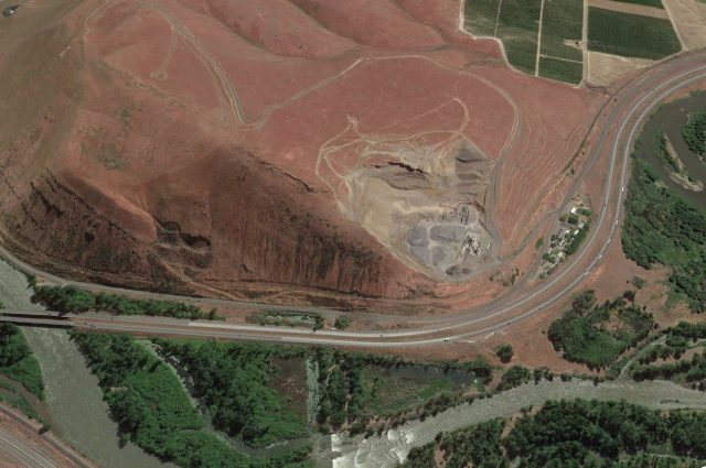
Google Earth image of the incipient landslide at Rattlesnake Ridge
.
In October 2017 a major fissure started to develop through Rattlesnake Ridge. Over the last three months this apparent tension crack has widened to encompass a volume of about 3 million cubic metres. KXLY has this image providing a perspective of the size of the block that is on the move at Rattlesnake Ridge:-
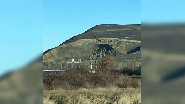
Image of the slope failure at Rattlesnake Ridge, via KXLY
.
Whilst the best impression of the feature can be seen in this Youtube video by Steven Mack:
.
This view of the feature is perhaps the most interesting, showing how the crack extends into the rear face of the quarry.
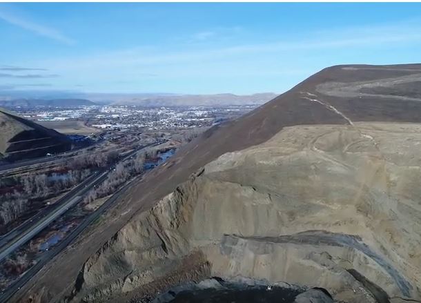
The slope failure at Rattlesnake Ridge. Image from a drone video on Youtube by Steven Mack
.
The latest reports suggest that the crack is widening at a rate of about 30 cm per week at present. Interestingly KIMA TV reports that the expectation is that the slope will self-stabilise:
Senior Emergency Planner Horace Ward said they have not determined a cause yet and said it’s just nature. Ward said the ridge is being monitored and they think the slide will stop itself.
“It could continue to move slowly enough to where it kind of just keeps spilling a little bit of material into the quarry until it creates a toe for itself to stop and stabilize the hillside,” he said.
The implication of this is that it is a rotational slip. However, the tension crack has quite a complex structure, with some evidence of the development of a graben structure:-
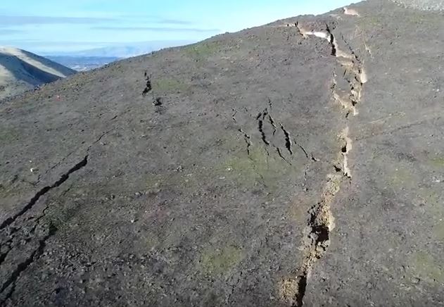
The trension crack at Rattlesnake Ridge. Still from a Youtube video by Steven Mack
.
Combined with the potential for weakening the materials controlling the deformation, this makes forecasting the likely future behaviour of this slope quite challenging, but of course it is the geologists on the ground who are best placed to make a judgement. In the short to medium term high resolution monitoring is the right approach.
Many thanks to the various people who highlighted this one to me, and provided links. Your help is very much appreciated.
 Dave Petley is the Vice-Chancellor of the University of Hull in the United Kingdom. His blog provides commentary and analysis of landslide events occurring worldwide, including the landslides themselves, latest research, and conferences and meetings.
This would be an excellent situation for installation of a portable LIDAR monitoring station to track slope movement.
[Agreed, and given the clearly safety issues that would be a wise move. D]
Rather reminds me of the slides along US 101 in Humboldt and Mendocino counties that closed the freeway.
I am a licensed geologist here in Washington State and I must say that this horrifies me. To think that this thing has the real POTENTIAL for mass failure and they have not closed the interstate that runs below this slope is amazing. Shipping containers to stop rocks from coming onto the roadway? Are they serious? Those shipping containers will be like beer cans in a shooting gallery. And the county has the audacity to call this slope “gentle”! Folks, this is serious and needs to be taken seriously. Let’s not forget lessons learned elsewhere in our great state i.e. Oso.
WAKE UP YAKIMA COUNTY DEPARTMENT OF EMERGENCY MANAGEMENT!! Get some engineering geologists and geotechnical engineers there and drill immediately to see how far this thing goes. WTF?
Totally agree Nick. This is an old landslide area as shown on the 1983 geologic map of Yakima Quad Washington. Not sure about drilling given the amount of movement. I would suggest rerouting freeway traffic at a minimum.
Please link to or cite that geologic map, Ron.
THERE IS NO REROUTE … EXCEPT ONE SMALL 2-LANE ROAD OVER THE RIDGE INTO MOXEE … OR FROM TRI-CITIES NORTH TO I-90 AND DOWN I-82 INTO YAKIMA …
i agree. Those shipping containers should be positioned across the lanes of the freeway to stop cars from traveling through. The containers aren’t going to stop 40 million cubic ft of rock and dirt. Oso leveled homes like nothing and was 20 million cubic feet. My fear is the containers will be pushed into the river and create an even bigger blockage. It’s just best to evacuate, close the I-82 and get people use to being rerouted now instead of waiting for the inevitable or getting someone killed.
The hillside is 1785 ft and already is spitting rocks out. A rock falling from that height hitting your vehicle could potentially go right through the roof or hood. This hillside is very dangerous and will go. Mother Nature will do her thing and no one can stop her.
Best of luck to everyone. I’m very concerned for all.
Jan 10th 2018 mudslides in California should warn Trumps usa , global warming is here mankind needs to wake up fast , stop silly wars hate and fear its time to stand up and act! All of us need to grow up and join as one cause mankind is on the brink right now!! ☹
Good morning David,
I am an engineering geologist working in open pit slope design, and while most of our instabilities can not be classed as Landslides, there are certainly many that can ! With regard to Rattlesnake Ridge, we had a very similar situation at an Iron Ore mine in South Africa situated in rugged terrain, and when I looked at the R/R images, it could well have been our project. Our slope developed with a similar crack pattern and sat quite happily for a number of weeks before failing catastrophically! Using the Inverse Velocity method from the monitoring data, our failure prediction date was good, and there were no casualties, other than equipment that had not been moved out of the “run out” range. I think that the KIMA TV report that the slope will self-stabilise is very optimistic !!
[I don’t think you are alone in that view. D]
Is the ridge itself part of an escarpment? The profile looks like a fault block. I wonder how much of the ridge is competent rock and how much is regolith. That might determine the extent of potential flow.
The gap which contains the freeway, rail line and river appears to be of long existence: was it uplift-downcutting by the river?
Rattlesnake ridge is a basalt anticline which runs west to east, perpendicular to the Cascade uplift. East of the Cascades are a number of such secondary folds. The Upper Yakima Valley Is a syncline positioned between several of these folds. The Yakima River is predates the folding and has cut through the ridge at this location. The south slope of the ridge is alluvium deposits from hydraulic actions of the Yakima River as it cuts the ridge. While the basalt is stable, as it rises and the arc of the fold tightens and the loose alluvium wants to creep/slide off. It appears to me that the removal of over burden by the gravel quarry has destabilized the slope. Those that think this will creep and slide slowly toward the quarry should reconsider. The separation became observable 3 months ago. There are some spaces already in the openings for a car to drop into. It is likely that the slope could collapse near bottom and shoot out across the Interstate and potentially block the Yakima River.
Amazing how the interstate is still open. Really makes me concerned about the decision making process. Hind sight is 20/20, assuming your still around to see.
That it’s caused by the quarry seems obvious to me (but I have no training in geology). If that is the case, I’m surprised your comment is the first mention of that – are they being held responsible, in terms of being made to generate and/or fund some mitigation or solution?
Thank you, you’ve answered my principal questions.
I think there has been a issue at this site for quite a while. Check out the aerial photos from 2011 in the link below. You can clearly see an old fault/failure plane in the same location as the current crack.
https://1drv.ms/b/s!AiFFyBPq2Lxfg6gxyNmTerBVny7GMg
I’m a retired geophysicist living in Southern California. Thanks for the interesting article and good comments.
Perhaps this would be a good location to install temporary seismic stations if it hasn’t already been done. I think it would also be interesting and desirable to install 24/7 webcams observing the creeping land mass from a few different locations from beyond the toe and across the valley.
I am an Engineering Geologist in Washington State practicing for over 20 years. I have worked on dozens of large landslides including the 2014 Oso Landslide, which killed 43 people. I do not want to see the mistakes that were made prior that disaster to be lost on this potentially similar situation. The nearby Nile Slide in 2009 also shares some similarities with the current landslide paradigm.
Yakima County is located in a very arid part of Washington State east of the Cascade Mountain Range so landslides are not generally on the top of the emergency contingency list. That just changed for Yakima County and the City of Yakima and Union Gap.
My advice would be contact the Washington State Department of Natural Resources if you have not already. They have a highly capable expert team dedicated to landslides. The Washington State Department of Transportation also has great team of Engineers and Geologists. The many Universities in Washington also have great Geologists and Engineers that are second to none.
People working on this will need data to see what kind of monster you are dealing with. Is it a creeper or a combination of creep/fail. This can be determined by developing a rapid deployment monitoring program. A common failure mechanism for landslides in flood basalts is a weathered clay interflow zone on an adversely dipping block. The graben structures forming at the scarp line do indicate that this may be what is happening here. Circular failures are not as common in the Columbia River Basalts. Determining the failure method is important in the failure models.
You will need portable LiDAR and/or daily survey point data (InSAR data if you can get it). You will need to drill and install inclinometers through the slide mass to see where and how the block is moving. This is dangerous so consult your experts to the level of safety concerns here if this is possible. You can use surface deformation points or automated tiltmeters for lower resolution data but you wont be able to identify the rate of slip at the failure plane. Crack extensometers can help you with the surface creep rate. These can all be automated and telemetered from the site. Identifying the failure plane is important and rate of movement is also important. These can be used to develop potential failure models.
If the slope does fail catastrophically it will likely block the Yakima River and certainly destroy US 82 and the rail corridor as well as the fiber optic and other regional communication lines that follow the highway through Union Gap. A blockage of the Yakima River, even briefly, can cause serious flooding in the City of Yakima directly upstream of the slide. If there is a train transporting chemicals at the time of a failure this too is in the mix. Although all of these things happening at the same time seems very unlikely, it seems the unlikely is always what happens paradoxically.
The long comment on this topic is intended to help those who are directly working on this issue and provide some ideas and positive steps toward hopefully avoiding a potentially dangerous landslide from being overlooked once again. MB
[Many thanks, I agree 100% that this problem needs to be taken very seriously. I worry about the casual way in which the potential for a highly mobile flow is being ignored. That is not to say that one is inevitable, or even likely, but the possibility needs to be a part of the thinking. D.]
I have been suggesting, and offering an TinSAR interferometer for a few weeks ….so far no takers …. silly. I have also seen a SatSAR dataset to 2014 ….the data will come out ……
..some will be surprised, and some less than thrilled …
We are working with an ASCE Geo-Institute team and some local contacts to prepare for a deployment as it may be a very good opportunity to assist those who are in the decision making positions.
LIDAR .. (sorry), nothing beats terrestrial InSAR for currency, velocity, and displacement data acquisition information. I will be visiting the site this week, and with local consultants who are looking at the bigger picture.
Why a mine-site (quarry) is allowing people on that ridge is beyond me, and is likely not in support of the MSHA ground Control policies and practices.
Let me preface this statement by first saying that I am not scientist or a geologist. Based on the numerous videos especially from 2021 boomer and the lazar time-lapse video from Conforth Consultants, Hillshade- S Ground Level View. , I believe we are about to witness a man-made earthquake unlike anything ever seen before. Considering the fact that earthquakes normally are at a depth of 4 miles to over 300 miles, and considering the release of energy is spread through 10’s to 100’s of miles between the release of energy from the epicenter of the quake, and considering the quakes are from friction and sliding tectonic plates makes this unbelievably scary. This is not going to be a case of energy transferred friction but instead it is possibly going to be an instantaneous snap at some point along the connected plates that appear in the time-lapsed video. In the video, it appears that the plates are connected across the west face of the hill to the bedrock that has rolled up on the southeast corner of the hill. I again wish to point out that I am not a scientist, but I am afraid for the people in the vicinity of this event. This theory is based on the drone videos and other youtube videos from EZC Productions, from 2021 boomer and from an on site video from JuanJ that give a very up close view of the cracks and the various elevation changes between the cracks. If you live in the vicinity of this hill, please look at these videos and draw your own conclusions from what you see. I see simultaneous movement on the western face, created by pressure between the two sides of bedrock that were penetrated/breached on the southeast face of the mined excavation site. It appears any southern movement of the so called slide is flowing from the original crack downward into and between the bedrock breached area, As this breached area continues to fill the pressure continues to move the mountain upward from the bottom of the breach and it looks like it is sliding up through the hill bulging out from near the southeast corner of the excavation site, and across a wide area on the western face. (Please see the video from Conforth Consultants, Hillshade- S Ground Level View.) This is only my opinion. What are the geological experts reporting? What is the news reporting in your area? I would be very interested to hear from a geologist and specifically someone who is an expert of tectonic movement instead of someone who studies landslides. Someone who is an expert step up and inform those who reside near this hill. It would be interesting and enlightening to see the lazar video footage from the last presentation to the public, Jan 13th I believe to the current time. The news releases have been less than forthcoming with information as though they are afraid breached bedrock area is going to be identified as the cause of the inevitable earthquake and landslide. Why is there not a looping camera feed of the movement that was last dated January13th? Due to the current precipitation, and the forecast for additional precipitation over the next few days, current data should be provided to residents of the area. Individuals upstream and downstream from the hill should be ready to evacuate at a moments notice at the very least. The non-closure of the highways that lay in the path of the impending event should be closed or lives will be lost.When the plates snap/explode there will be flash flooding, are the citizens being made aware of this likely possibility. The residents should be provided with current factual data. Pointing out the seismic equipment on the hill is not information. What data is each stationed device reporting? An update looping video from Conforth Consultants, Hillshade- S Ground Level View should show the time loop from Jan 1 to live real time images of the movement of the hill, and it should be available for viewing 24 hours a day. The report that the movement of the hill has not accelerated is not good news, it is quite the opposite as the movement slows the pressure continues to build toward the undeniable, inevitable cataclysmic event. Stop worrying about who is going to be blamed for this and start preparing the residents for the worst possible case scenario. You news stations have failed your viewers and you need to dig and hound the so-called experts to provide you with current/accurate information. Failing to report the truth about this horrific event is very irresponsible and bordering on negligence. Focus on saving lives and the blame game can be played after, failing to report puts you in the spotlight of those to blame. Do your job, this is actual news that should be the focal point of all of your aired programing.
Are you sending your professional observations to the town of Yakima ? the news stations, papers, bloggers in the area ? I would also bring on Desmog, Young Turks, …any alternative news that will listen. This is pure crazy making, insanity in the making by the Yakima county and there third parties. Please, save a life and push these bureaucrate’s into reality. Thank-you for your comments here, as a lake in Alberta coincidentally cracked and heaved right around the same time. With fracking , and fracking in a known seismically active part of our coast….. you do not hesitate to protect your citizens. Thank-you !
I’m no geophyicist, just a local with an intimate mental map of the area who wanted a deeper understanding of the geology of Rattlesnake Ridge than was being reported in the media. Frankly, I think the “experts” calling the shots on this are being awfully optimistic about the bulk of the slide landing in the quarry and not on top of my car on I-82 just before it creates an earthen dam and blocks the Yakima River’s channel through the gap. From my living room window north of Moxee It will be quite a show when the ridge’s big toe slips. Thanks to everyone commenting I appreciated your insight and knowledge!
Rather than the “Wait & See Approach” until it Does Fail Catastrophically … Close the Highway , Secure & Clear The Immediate Area & Dynamite the Fracture , Thereby Taking Control of an Extremely Dangerous Situation where No Life is left at Risk & Removal of waste can be cared out promptly rather than “Waiting at the bottom of the Cliff to call in the Ambulances ” for the dead in the event that it fails , Any Roading Engineer with Intelligence will tell You its better to take it put under “Controlled Conditions” then leave it to Collapse and Fail by Itself…
Rather than the “Wait & See Approach” until it Does Fail Catastrophically … Close the Highway , Secure & Clear The Immediate Area & Dynamite the Fracture , Thereby Taking Control of an Extremely Dangerous Situation where No Life is left at Risk & Removal of waste can be carried out promptly rather than “Waiting at the bottom of the Cliff to call in the Ambulances ” for the dead in the event that it fails , Any Roading Engineer with an Ounce of Intelligence will tell You its better to take it out under “Controlled Conditions” then leave it to Collapse and Fail by Itself…
The preliminary geotechnical report was linked in local media coverage by Seattle Times in October and is publically available at
https://www.documentcloud.org/documents/4344415-Prelim-Geotech-Assess-AK-Anderson-Ground-Movement.html
It provides some data and interpretation regarding the questions posed above. Interestingly, though the authors conclude the likely movement of the active slide will be slow and in a southerly direction, their Figure 8 discloses an adjoining “interpretted suspect landslide” with clear topographic controls toward the west.
JG
This moving mass would be an excelllent candidate for regular (and inexpensive) UAV/drone surveying. A nice digital elevation map could be created and updated to give the surface deformation. Further seismic monitoring may give crackle and snap warnings of what’s happening in the subsurface. All of this information could be used to understand the failing rock as well as provide a series of alert flags. This could not only help with the specific problem, but provide a case history relevant to other areas.
Blow it
Yes, Blow it
Could the removal of all the earth around the site be the cause?
If this is Union Gap, there is a piece of history going too. I think there is a sign put up, on the west side of the gap, to mark the battle of Pah’-qy-ti-koot. The US Army lost this battle.
I’m surprised that no one has published at least a sketch of the impact of the river being blocked. How far up the river will the flooding have effect?
Actual incidents provide vital yardsticks to assess the situation at Rattlesnake Ridge: The Aberfan Tip disaster, the Vaiont (Vajont) Dam disaster, the Montaro River Slide: all were proceeded by formation of tension cracks behind the upper edge of the slopes. It is imperative as suggested in previous contributions to this discussion that means be put in place to assess accelerating creep. One shouldn’t presume a slope stability analysis proceeded the emplacement of the highway (the cracking doesn’t seem to have been anticipated). It may be many months before the slope collapses but for myself…I’d get the hell out of there.
It is important to compare this situation to those that proceeded previous landslide disasters: the Aberfan tip failure, the Vaiont (Vajont) Dam landslide, the Montaro River slide. All were proceeded by the formation of tension cracks behind the upper edge of the slope. It is imperative, as suggested in previous contributions to this discussion, that some means be set in to monitor accelerating creep. It should not be presumed that any previous slope stability analyses were performed; the cracks were unanticipated. It may be many months before failure but for myself…I’d get the hell out of there.
It is important to compare this situation to those that proceeded previous landslide disasters: the Aberfan tip failure, the Vaiont (Vajont) Dam landslide, the Montaro River slide. All were proceeded by the formation of tension cracks behind the upper edge of the slope. It is imperative, as suggested in previous contributions to this discussion, that some means be set in to monitor accelerating creep. It should not be presumed that any previous slope stability analyses were performed; the cracks were unanticipated. It may be many months before failure but for myself…I’d get the hell out of there.
The Rattlesnake Ridge development mirrors those precursors that proceeded the disasterous landslips of, say, the Aberfan Tip, the Vaiont (Vajont) Dam and the Montaro River Slide: the formation and continuous growth of tension cracks behind the upper edge of the slope. These cracks can develop many months before slope failure. It is imperative, as suggested previously, that the Rattlesnake Ridge slope be monitored for indication of accelerating creep; a harbinger for imminent failure. Apparently there’s been no slope stability assessments as none seem to be reported.
What initiated this portion of the hillside to crack? Does it have anything to do with the rock quarry excavation? Who owns the quarry?
My question as well! I don’t understand how there is even a quarry in such close proximity to a historically documented fault line.
Hi All,
Here is the link to the WA DNR website on the site https://www.dnr.wa.gov/rattlesnake-hills-landslide . VERY informative and great information about how amazingly well monitored this is. Still looking for and hoping to find online access to those monitoring stations for curiosities sake.
https://www.dnr.wa.gov/rattlesnake-hills-landslide
DNA has summary of monitoring here.
When I see rock crystals being sold at newage (rhymes with sewage) fair booths, I put on a rant — telling them they need to take all the crystals back where Mother Nature had them, to keep the Earth stable. (My wife has learned to leave the area rather than try to wind me down (grin)).
Well, about this quarry. If one were to put all the removed material back, would that be enough to stop the slope failure, as Emergency Planner Ward is quoted as saying above? To put enough
“material into the quarry until it creates a toe for itself to stop and stabilize the hillside …”
Hm? So how much would it cost to buy that much rock and gravel and haul it there to fill the hole? More than the profitability of the quarry, I’d bet.
Someone must have done the cost/benefit analysis — didn’t anyone think of taking the gravel off the _top_ of the slope instead of removing the toe from the slope? Hm?
When I see rock crystals being sold at newage (rhymes with sewage) fair booths, I put on a rant — telling them they need to take all the crystals back where Mother Nature had them, to keep the Earth stable. (My wife has learned to leave the area rather than try to wind me down (grin)).
Well, about this quarry. If one were to put all the removed material back, would that be enough to stop the slope failure, as Emergency Planner Ward is quoted as saying above? To put enough
“material into the quarry until it creates a toe for itself to stop and stabilize the hillside …”
Hm? So how much would it cost to buy that much rock and gravel and haul it there to fill the hole? More than the profitability of the quarry, I’d bet.
Someone must have done the cost/benefit analysis
Greed; profit; and indifference to everything else is at the bottom of nearly all human endeavours…. especially of this type! I know….I lived 12 years of my life below a mountain quarry in the Italian Alps. (Over the western ridge of the Vajont calamity, as a child which I witnessed!)
Thanks for the post and thanks to all the informed commenters above (licensed geologists, etc) for sharing their info. Whatever happens, you can be sure that the quarry owners will privatize the profits and socialize the costs of this disaster-in-waiting, it’s the American way!
Can someone look at Rosies999 video of around 3/27 at minute one fifty nine to two minutes and three seconds of her roughly five minute drone footage, it appears to show a slight bald line that is not straight but is heavily zigzagged with a general curve of it connecting just below the first layer of basalt (nearest the sky). It would be on a northerly “corner” where the hill turns to its north face, a fair piece above the current watched area.
A section of concern further north, nearly on the north face itself, could put more pressure on the slide that is expected or indicate a second area of failure?, or a bigger issue than is currently understood. I don’t have great ability to change the resolution of the image, to see if what I think I see is right. I am told there is no animal trails on this hill, and rain and rock falls seem to be more straight. This looks like a wiggly line seen on a CHF heart, of a heart that has no great ability to pump on an echocardiogram. I don’t think rain does that.
I echo the concerns said by others, better to prevent a tragedy than hope one does not occur. It’d be nice if it would slip into the quarry area, but not too likely, life is tricky like that. Prayers to all!
So you are saying trigger it? A controlled landslide?
https://www.gofundme.com/rattlesnake-ridge-monthly-satsar
Those are some huge cracks! Horrifying to think that the portion of the ridge could collapse at any moment. Definitely a good idea to have geologists and officials monitor the area to prevent a potential landslide. A good heads-up. We at appreciate this post.
Huge cracks! Horrifying to think that the portion of the ridge could collapse at any moment. Definitely a good idea to have geologists and officials monitor the area to prevent a potential landslide. A good heads-up.
Hi everybody I’m just concerned assistant I live in Granger Washington I just want to know how bad is this going to be do I need to move further away I mean if some of you think there’s going to be an earthquake or it’s going to be a catastrophic never seen before situation I just scares me to think I just want to know can you please let me know I thank you for your time and for your attention and answering my question I have family in Kennewick and Sunnyside so I’m concerned thank you God bless
I’m a concerned citizen that was a typo I do apologize for that