
15 November 2019
The Blackhawk landslide
Posted by Dave Petley
The Blackhawk landslide
The Blackhawk landslide is without doubt one of the most impressive rock avalanches on Earth. It is located at 34.393, -116.773 in the Lucerne Valley on the escarpment that divides the San Bernardino Mountains to the south from the Mojave Desert to the north, in California. This is a Google Earth image of the landslide source and deposit:-
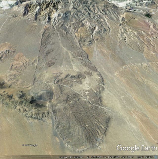
A Google Earth image of the Blackhawk landslide in the Lucerne Valley of California.
.
As the image shows, this is a landslide on a very grand scale. With an estimated volume of about 300 million cubic metres, the landslide extends over a distance of about 9 km from the crown to the toe, with a deposit that is up to 2 km wide and up to 30 m thick. The fall height is estimated to be about 1,200 m in total, making this a highly mobile landslide.
The event is not recent. Dating of the deposit suggests that it may have occurred about 18,000 years ago, although there is huge uncertainty in that date. However, in the dry desert environment of inland California the landslide is exceptionally well-preserved, and of course the landslide mass contrasts with the valley floor, rendering the mass highly visible.
This is a landslide that is surprisingly poorly investigated. There is a very nice PhD thesis from 1959 by Ronald Shreeve that is online, which describes the geology and mechanics of the landslide. This was in the days in which a PhD thesis could be just 84 pages long (there are lessons to learn from that!). Shreeve describes the geology, and tries to explain the exceptional mobility of the landslide, hypothesizing that it may have moved on a lubricating basal air layer. There is also a nice blog article about it on the excellent Looking for Detachment blog. Finally, there is a book chapter from 1978 about the landslide by Brann Johnson, but even the University of Sheffield subscription to Science Direct does not provide access to that one.
This is landslide that would really benefit from a revisit using up to date techniques. There is exquisite hummocky morphology in the landslide deposit, captured well in the this 2006 Google Earth image:-
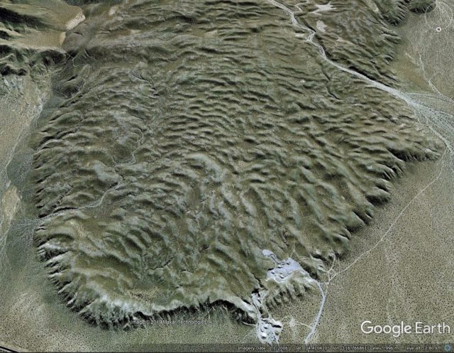
Google Earth image of the Blackhawk landslide in California
.
And to me, the now dissected landslide source area suggests that this might have been quite a complex event too. This is a Google Earth image of the landslide scar area; I have annotated the approximate boundaries of the upper part of the deposit:-
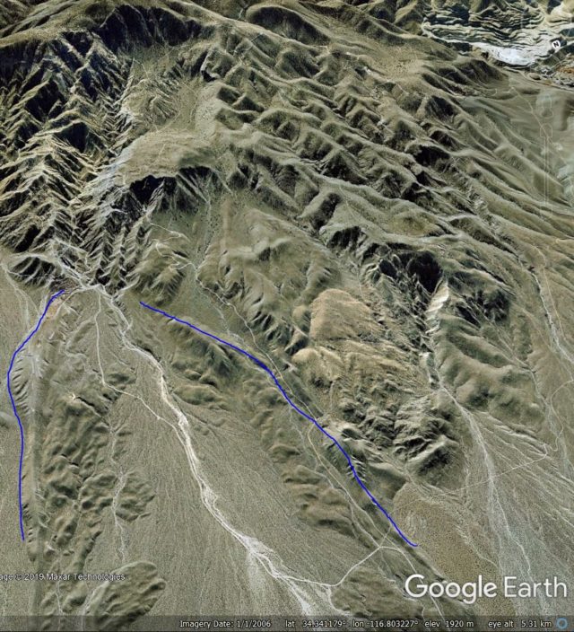
Google Earth image of the source area of the Blackhawk landslide.
.
The implication appears to be a highly unusual morphology of the landslide scar. It is not clear to me how the mechanics of this part of the landslide motion would have operated – is there a large volume of stalled material still within the scar area?
Acknowledgement and footnote
Many thanks to my friend funkenbeachin for pointing out this landslide, and for the discussions about it. He has hypothesised that there may be other events in this area as well – take a look at the image below. It is not hard to believe that there is more than one landslide deposit on the valley floor:-
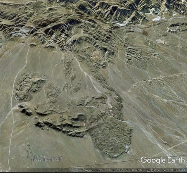
Wide angle Google Earth view of the valley floor around the Blackhawk landslide
 Dave Petley is the Vice-Chancellor of the University of Hull in the United Kingdom. His blog provides commentary and analysis of landslide events occurring worldwide, including the landslides themselves, latest research, and conferences and meetings.
I wish there were a larger frame with this area embedded — just being spoiled. I mean I did try to find it on google earth, which was enlightening in itself and fun, but I didn’t find it
Thanks for the post, I live very close to this landslide and its always captured my imagination. there is a surprising lack of in depth information about it.
I cheked out the landslide on Google Earth as my mind could not process the description given for the landslide relative to the screen grabs. Looking at the landslide from the side and more or less in profile made it much easier to comprehend what I was reading and seeing.
Thanks for sharing! This is a most excellent landslide. Really surprised more have not studied it.
Nothing compared to mt. St. Helens
What is your estimate of the duration of the slide event? How do you come to that conclusion?
https://www.google.com/maps/place/CA-247,+California/@34.4052903,-116.7857973,8867m/data=!3m1!1e3!4m5!3m4!1s0x80c4c16c25b6727b:0x2d5a5aa59082cc47!8m2!3d34.4177909!4d-116.741477
I live 20 miles from the landslide area and have driven past it many times in the last 34 years. I had always thought it was an unusual geological formation? It was probably only 5 years ago someone had told me about the ancient landslide out past Lucerne Valley, I knew exactly where and what they were talking about when they told me!
I visited the site in 2014 and blogged about it with annotated graphics and on-the-ground images. The actual post is here: https://earthly-musings.blogspot.com/2014/12/southern-californias-blackhawk.html.
It its unfortunate that the site is not protected as a geo-heritage site and much vandalism and trash dumping is occurring here. Nonetheless, a very impressive site!!
I finally found it :-):
https://www.google.com/maps/@34.523292,-116.7546151,4456a,35y,180h,75.87t/data=!3m1!1e3?hl=en-GB
Thanks for the post. Looks like the quarry on the north-west side of the landslide toe might give a nice glimpse into its make-up. ‘click’, do you live close enough to take a look?
Shreve’s thesis eventually became a 1968 Geological Society of America Special Paper (#108). I first learned about this landlide from John Shelton’s 1966 book, “Geology Illustrated”, and have always thought of it as one of the examples behind Jay Melosh’s acoustic fluidization process (recent, free access, with references: https://agupubs.onlinelibrary.wiley.com/doi/full/10.1002/2016JF004093
01 05 2020
I would like to see the Landslide history highlighted in the local history.
I visited several agencies and NO one knew about the landslide in history to my surprise.
Nothing like St. Helen’s no compared to property damage and lost lives. Of that time 4,000 years ago it was the most geo event of its time of local history.
Again we are referring to LOCAL history –
Nick Everett, I hope you find this response, as it’s been a year since you asked your question.
I have visited the Blackhawk landslide several times to see if I can learn how to recognize them when they are very old and weathered. Sorry I didn’t take pictures, but have found some pictures online you can access at these two blogs:
1) shallowsky.com/geology/socal/blackhawk, Has photos of Blackhawk slide, if you number them left to right, we can refer to them.
2) Commentor Wayne Ranney has a blog with photos of Blackhawk.
The walls of the gravel pit are loose, gray marble gravel of different sizes, except for a two foot thick, indurated layer of Caliche located just under the surface of the flow. It’s composed of the same gray marble gravel the rest of the slide is made of. This layer of caliche can be seen in at least two of the on-line photos:
Shallowsky pic #16 at the quarry entrance shows the layer of caliche on top of the hill in the center.
In Wayne’s blog, a photo of trash in the quarry, shows the caliche layer at the top of the excavation.
I found it interesting to compare this layer of caliche topping the Blackhawk to the Silver Reef slide, which is several miles down the road, on the east side of the Blackhawk. While the Silver Reef is composed of the same gray marble, it is indurated much harder than the Blackhawk, and completely through the deposit, down to the surrounding ground level, which I think qualifies it to be called Breccia. It’s surface is more eroded having hardly any loose soil left, leaving more of the hard caliche/ breccia exposed. What little soil is left supports some different vegetation, like cactus. It’s older age is quite obvious.
Regarding Shallowsky’s photo #11, with the caption asking ‘what’s the white stuff in the holes” in an arroyo wall: I wonder if it may be degraded cement that was created by the heat of friction between the tumbling rocks, cooking patches of the marble. The Kofels rockfall got temperatures up to around 1700 degrees C. which created porous, pumice-like rock where no volcanic rock exists. It requires less heat than that to make cement from marble. A Thermoluminescence test should tell if it’s been heated, and maybe even how long ago.
I agree with David and others that this rockfall deserves to be re-studied with up to date methods.
Chuck Williams
Nick Everett, Chuck Williams I’ve lived in Lucerne Valley for 35 years. I’ve studied geology and have an extensive collection of meteorites, fossils and amazing rocks from this entire area. Since the XRF readers have come out I’ve been anxious to see an archaeometry report on the area west of Old Woman Springs. Growing up, me and my friends wandered through all these amazing rock formations, and the land in this part of the desert seems like it’s been mined already. Washed out, although it seems like there’s no mines to be seen there anymore. I have tons of pictures taken with my Nikon P900 from Blackhawk and the surrounding area. You definitely need 4WD to get a closer look. The rocks are an amazing mess of conglomerates, combinations most have never seen anywhere else but here. There are stories of a village that was buried under the slide. That would be an interesting find. Love to see a LIDAR image of that!
Lisavette (Leesie) Barden
Well, this is a very interesting debris flow indeed!
I was lucky back in the early 90’s to do a bit of silver-gold and industrial mineral prospecting there. Yup. It’s source area at the break away zone on the modern mountain front, above, is reddish and contains old workings. Some parts of the slide is also reddish (see Google Earth). The debris flow was derived from this Ag>Au system that is part of the NW trending basin-bounding fault system of the “San Berdoos”. Optimistically, the slide might be “open-pittedable” if silver prices explode. There are several adits within the slide area, one of which has an upright, derelict but picturesque, white porcelain toilet at the very end. A poor view from it, though. There are also bulldozer scars from claimholder work in the past on the slide surface. No known mining, mill sites nor good roads. Just yearly proof-of-work sort of activity.
In the church of sedimentology, this is a coarse, boulder to rock flour, ungraded, unsorted diamictic, polymictic breccia. That’s somewhat redundant. And I don’t recall “reverse grading”, sensu strictu. And I do prefer “breccia” since ‘conglomerate’ suggests stream sedimentation.
Fresh debris accessed by the adits displays a variable tint with medium grey zones generally corresponding to mineralization and light grey to less mineralization. Again, this was already mineralized at debris fall time. The clasts are generally remarkably subround in shape due to mechanical impacts within the slide during high energy deposition. I don’t believe they were stream gravels. This rock texture suggests “churning” as the slide did its thing. The debris is also somewhat friable by rock hammer, in keeping with it never have been completely buried and only by encroaching alluvial fans nearest the mountain front, since the Pleistocene event(s).
I wonder whether this is a composite of several ‘pulses’ related to rapid San Bernardino uplift and accompanying mega quakes? No weathering horizons ‘noted. Anywhere.
The slide seems to display a coarsening towards the source. I drilled the slide just below the breakaway zone in the “piedmont” area. The marble hills next to where I drilled is possibly part of the ramp structure. I encountered abundant large boulders of white marble (the targets) that I didn’t encounter further out in the slide.
The San Andreas is southwest of here, on the other side of the mountains, near Interstate 10 and is mapped in detail as a reverse and strike slip fault . There, ?Mesoproterozoic crystalline rocks are “thrust” over alluvium in ~NE-SW trending segments connected by NW trending right-lateral strike slip segments. Thus, the San Berdoos might be considered a rotating horst block subject to steady uplift and strong, periodic shakes as the San Andreas system tries to “straighten” the curve imposed on it on one side of the San Berdoos while the Lucerne Valley pull-apart basin makes room for the Blackhawk to fall, on the other.
As to preservation, I believe it is BLM land in a profound rain-shadow with endangered species, so won’t be bulldozed flat and turned into a condo project within the existence of humankind.
My own research in Central Nevada suggests a similar slide or series of slides of Late Cretaceous age breccias, also derived from carbonates so similar but bigger than Blackhawk. I’m doing a short talk on it at GSA Spokane this Spring so, more, later!
I live 2 miles north of the landslide n though I’m not a geologist I’ve spent many hours studying this site. In fact I’ve discovered a small land mass approximately 60ft wide by 70ft in length at a height of 30ft that appears to be petrified forest patch. In this area west of the slide there are rocks that appear to be tree stumps, like an area where logging was done but the forest patch I’m speaking of is like looking thru a windows back to when the forest was thick, trees touching each other very large bases. You can see that the trees were pushed down on their side n some were tore out. There’s tree park petrified n tree stumps still bearing the age rings. My favorite is a tree roughly 20ft long 2ft round laying on top of a decomposing granite rock n its definitely petrified without a doubt. I’ve tried to pass on this information to experts but nobody seems to take my word for truth. Hopefully one of you rock hounds can do some research. The slide is mostly crush blueish Grey gravel in clumps n that’s everywhere. It’s strange to see pulverized rock in a large mass similar to visiting a rock quarry…if anyone would like me to be your local guide, need a sample or would like me conduct work please text me with subject Blackhawk slide at 760 490 2380 brent enjoy