13 February 2019
Pre-failure movement analysis of the Su Village (Sucun) landslide in China
Posted by Dave Petley
Pre-failure movement analysis of the Su Village (Sucun) landslide in China
Back in April 2018 I wrote about an analysis of the Su Village (also known as Sucun) landslide in Zhejiang Province, China in 2016. This landslide, which was caught on video, killed 27 people. The analysis in Landslides published last year (Ouyang et al. 2018) indicated that some pre-failure deformation of the landslide had been detected. A new paper, also published in Landslides (Ouyang et al. 2019), examines this aspect of the landslide in more detail, considering in particular the degree to which pre-failure deformation could be detected using satellite imagery.
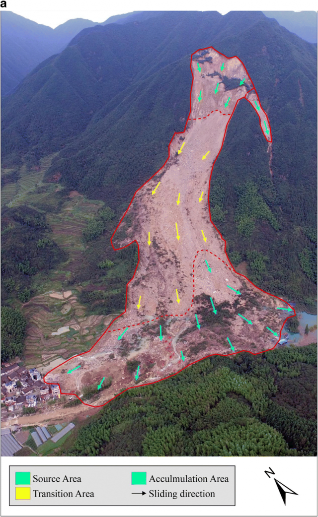
The paper includes the image below of the landslide, showing clearly the source zone for the failure (marked with the green arrows), the landslide track (yellow) and the deposition zone (in green again). The area in which the landslide impacted upon the village can be seen in the lower left corner of the image:-

Annotated sketch of the Su Village (Sucun) landslide in Zhejiang Province, China. Image from Ouyang et al. (2019).
.
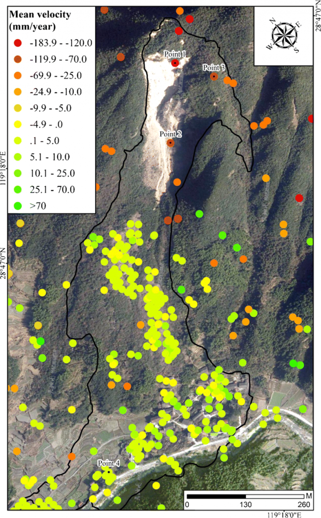
The authors used Sentinel-1A SAR (radar) imagery to investigate pre-failure deformation of the Su Village landslide, based upon an analysis of the 36 images using Persistent Scatterer Interferometry. The image below shows the points that were analysed across the landslide and its adjacent slopes, with the colours indicating the magnitude of the movement detected:-

Analysis of the pre-failure deformation of the Su Village (Sucun) landslide using PSI. Image from Ouyang et al. (2019).
.
My interpretation of the is that the yellow and green dots show no movement beyond error in the technique, whereas the orange and red dots show detectable deformation. The failure initiated in the source area shown in the first image, which then caused the rest of the slope to collapse, so it is reassuring that the detectable pre-failure deformation is situated high in the slope. The highest rates are in the section of the slope that collapsed, close to the crown of the landslide. But note also that significant deformation is seen in adjacent slopes that, at the time of analysis, had not failed. Thus, the InSAR results do not give a spatial indication of the likely form of the final failure (whilst also suggesting that there may be other hazardous areas on this slope).
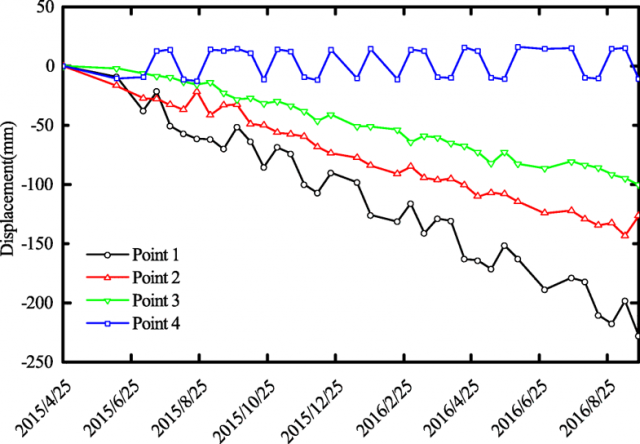
The displacement – time series graph also shows the results of this analysis, based on the points shown in the image above:-

Time series analysis of the pre-failure deformation of the Su Village (Sucun) landslide using PSI. Graph from Ouyang et al. (2019).
.
There is a mixed picture here. The good news is that statistically significant movement was detected in the areas that failed, whilst the unfailed areas displayed no trend (with some noise). But the detected movement is linear with time in all three points with above-error deformation, meaning that no inferences could be drawn to indicate time of failure. Thus, whilst the analysis shows that the slope was creeping, it could not be used as a warning system.
This paper is another very useful contribution towards the use of InSAR data for rock slope failure detection in natural slopes. But, once again, it shows that this is a very complex and challenging problem, and that our satellite based systems do not yet have the maturity to be used operationally in many cases as yet.
References
Ouyang, C., Zhao, W., Xu, Q. et al. 2018. Failure mechanisms and characteristics of the 2016 catastrophic rockslide at Su village, Lishui, China. Landslides. https://doi.org/10.1007/s10346-018-0985-1
Ouyang, C., Zhao, W., An, H. et al. 2018. Early identification and dynamic processes of ridge-top rockslides: implications from the Su Village landslide in Suichang County, Zhejiang Province, China. Landslides. https://doi.org/10.1007/s10346-018-01128-w.


 Dave Petley is the Vice-Chancellor of the University of Hull in the United Kingdom. His blog provides commentary and analysis of landslide events occurring worldwide, including the landslides themselves, latest research, and conferences and meetings.
Professor, this is again a treatise on “what-ifs” and “is it real”?. I humbly submit, and in support of the need for the development of processes to better support rural communities in hazard-prone areas, SatSAR is a useful tool for getting an idea where at-risk areas are, and if they are active. I believe now that most “practitioners” are looking at this backward. Advances in our toolkits (geo-professionals) and their affordability, return the onus to ourselves.
The satellite SAR units, like our Ground-based SAR instruments, are best able to offer data — when they are enabled to offer data. If they are not operational, no-good can be had.
Where we live across the globe have placed many communities in at-risk areas. Consider that we work backward.
1. We know where people live.
2. We determine if it is an at-risk area. (some of this is obvious, sometimes not. Where not, deploy drones with LiDAR capabilities, or use a LiDAR archive and infill with images — of known at-risk or slide areas. (We did this at Nisqually (WA) — where we used circa 2015 LiDAR that was only available and then meshed that with imagery of the actual slide to create a “current” DTM, clearly showing the slide and its surrounds.
3. Where warranted and based on our geo-professional experts view of slopes, local accounts, and national geo-information we know NOW, where to consider more frequent, or higher resolution SatSAR, OR to bring in a Ground-based SAR unit for Risk Reduction Monitoring (RRM, or Critical Slope Monitoring (CSM).
4. We scan and now we have data that can fulfill nearly all considerations of active displacement — or not. Displacement with a velocity that is cause for alerting and concern, or active Hazard Map supported engagement and community event response levels respected and detailed in a Trigger Action Response Plan (TARP).
5. Only humans and $$ resources separate us being able to apply the science we know now for almost two decades — that is rapidly evolving to real-time radar capture and alerting — and assuring that communities like Su Village are aware of and participate in their own wellbeing and safety.