
7 May 2021
The March 2011 landslides in Antonina and Morretes, Brazil
The March 2011 landslides in Antonina and Morretes, Brazil
Jefferson de Lima Picanço and Dave Petley
On 10 and 11 March 2011 unusually intense rainfall affected the Paraná State coast at Antonina and Morretes in Brazil. This rainfall event killed four people and left two other missing, as well another 221 people injured.
The rainfall triggered large numbers of landslides, including translational slides on steep slopes, rotational slides and mudflows. Downstream there was extensive flooding and large volumes of sediment were deposited. The images below show of the landslides triggered by this event:-
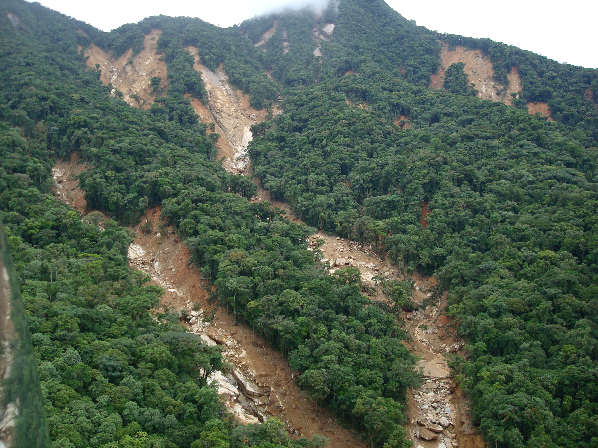
Multiple landslides triggered by the March 2011 rainfall event at Antonina and Morretes in Brazil. Photo courtesy of Renato Lima/CENACID.
.
These landslides were translational slides on the interface between bedrock and regolith in stepp upland catchments. Note how they have been channelised to form flows that appear to have eroded large volumes of sediment out of the channels.
Unsurprisingly the effects on the channels downstream were profound:-
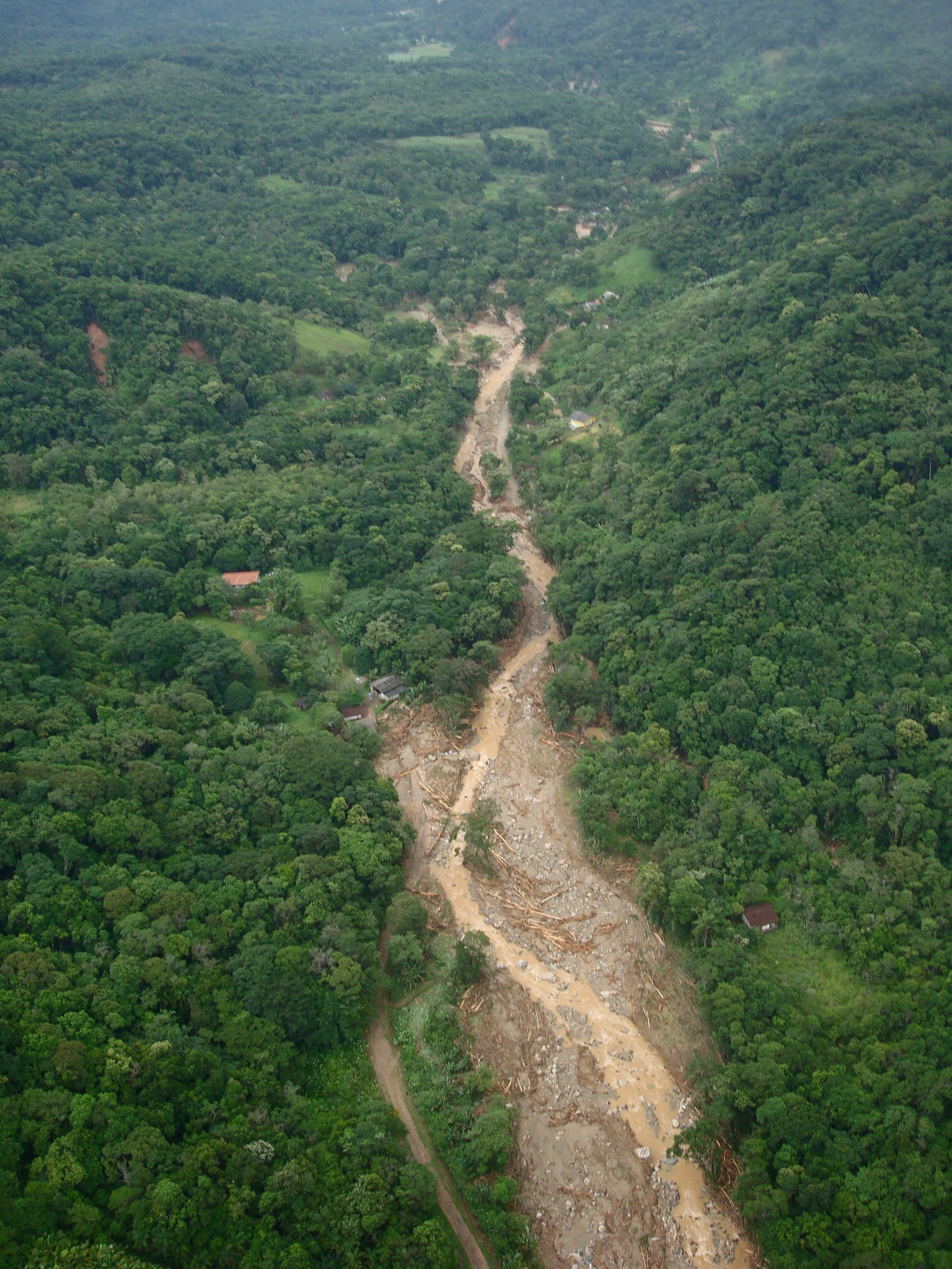
A channelised landslide triggered by the March 2011 rainfall event at Antonina and Morretes in Brazil. Photo courtesy of Renato Lima/CENACID.
.
Landslides also occurred on smaller slopes close to houses, causing substantial levels of damage:
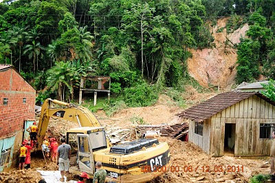
A landslide close to houses, triggered by the March 2011 rainfall event at Antonina and Morretes in Brazil. Image courtesy of Erly Ricci.
.
In the lowland areas, the sediment released by the landslides caused extensive damage through inundation and deposition:
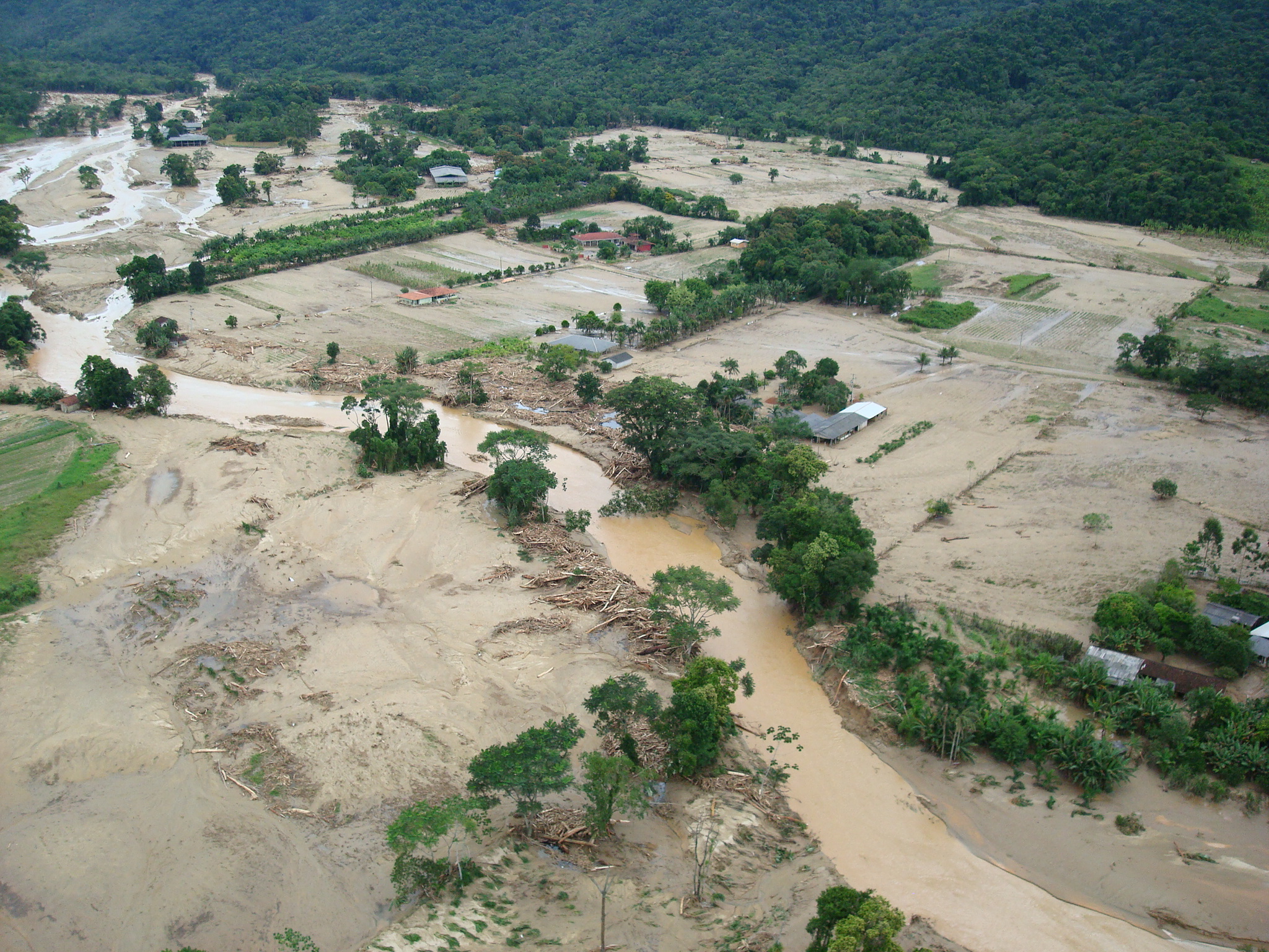
Downstream inundation and deposition damage caused by the March 2011 rainfall event at Antonina and Morretes in Brazil. Photo courtesy of Renato Lima/CENACID.
.
Further details of this event can be found in a paper (Picanço and Nunes 2013).
.
Reference
Mount Kekachi: an interesting rock slope failure and rock avalanche in Japan
Mount Kekachi: an interesting rock slope failure and rock avalanche in Japan
Yesterday the Toyama Prefectural Police Mountain Guard tweeted a set of images of the aftermath of a large rock slope failure and rock avalanche from the flanks of Mount Kekachi in Toyama Province, Japan:-
【毛勝山大明神尾根北側斜面での大規模な土砂崩れ発生】
5月6日の県警ヘリ「つるぎ」のパトロールで、大明神尾根北側斜面で大規模な土砂崩れを確認しました。土砂は大明神沢~阿部木谷下部の砂防堰堤まで届いています。毛勝谷や阿部木谷への登山や山スキーを計画している方は注意してください。#山岳 pic.twitter.com/S6V2ceSI3X— 富山県警察山岳警備隊 (@toyama_sangaku) May 6, 2021
.
The three images provide a remarkably good view of the events. It is clear that this was a large detachment from a near vertical face:-
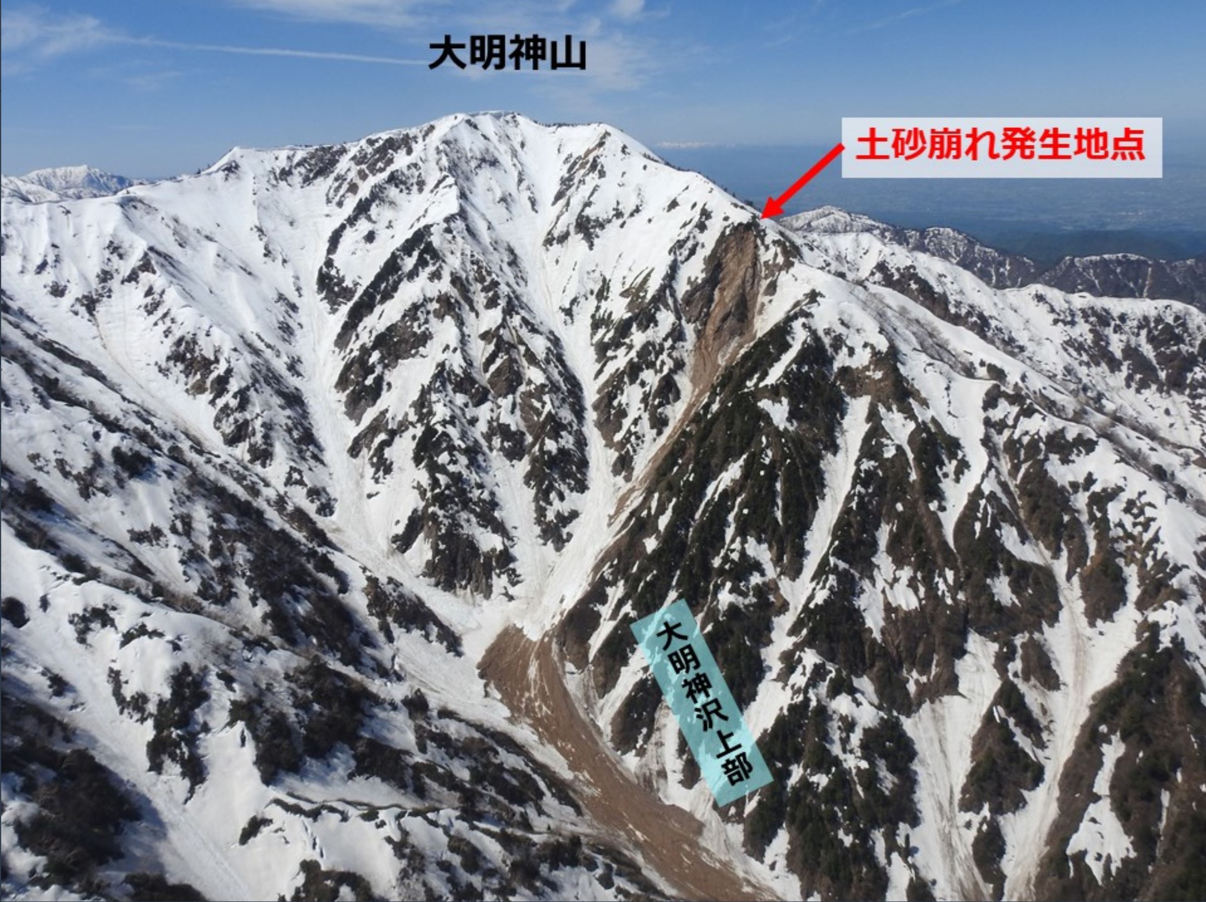
The aftermath of the rock slope collapse and rock avalanche on Mount Kekachi in Japan. Image tweeted by the Toyama Prefectural Police Mountain Guard.
.
The debris has then followed a very steep gully in the form of a rock avalanche. Yoshi Kariya has estimated some statistics for the landslide, which occurred on 6 May 2021. It is about 2 km long with a vertical fall of about 900 metres. The rock avalanche overran by a sabo dam (a check dam across the valley), but stopped a short distance further down the valley.
In the Twitter chain Paisun88 has tweeted some images on the ground showing the rock avalanche material:
https://twitter.com/exp88/status/1390226175067234311
.
The Google Earth image below shows what I interpret to be the location of the rock slope failure:-
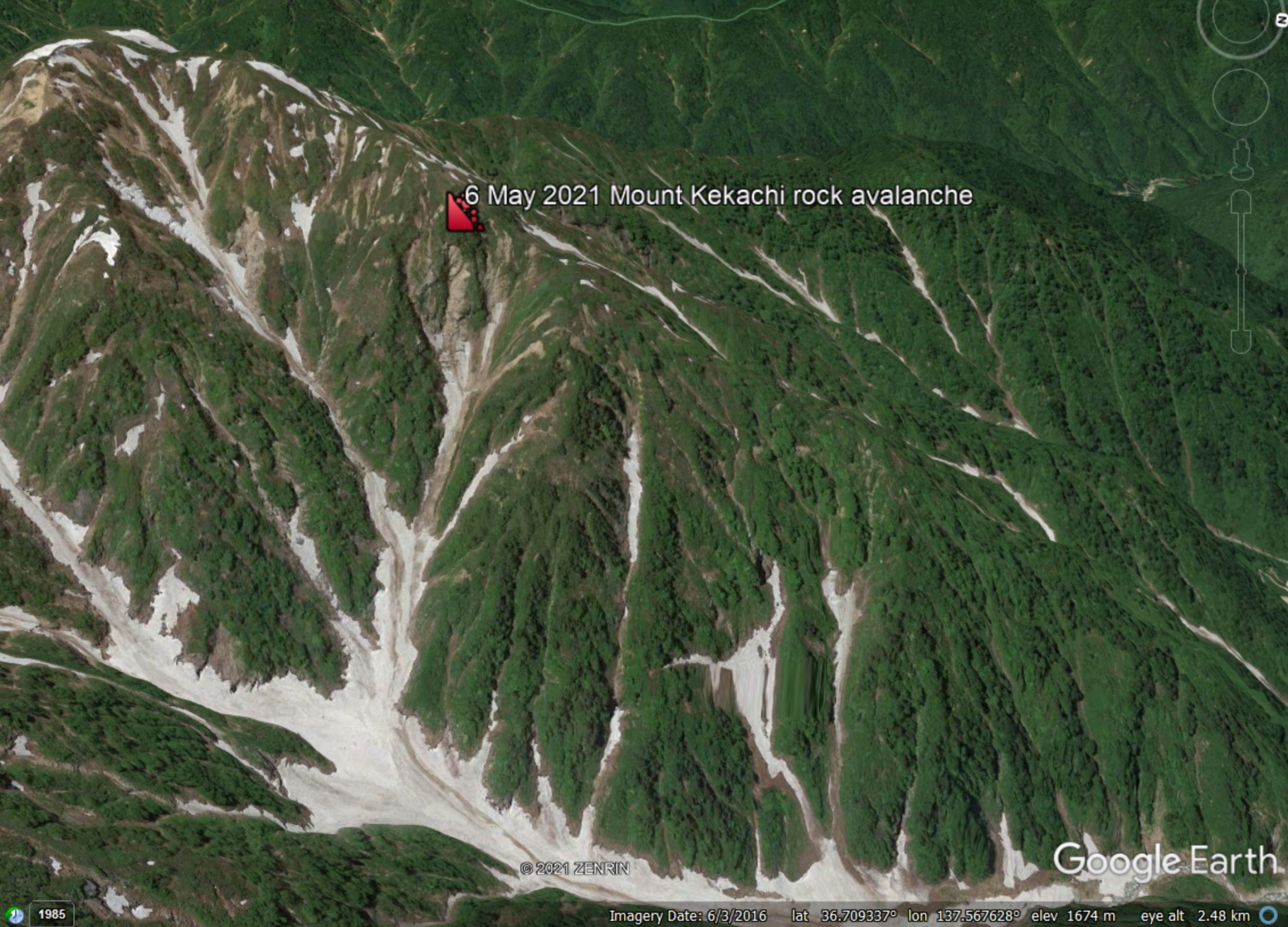
Google Earth image showing the inferred location of the rock slope failure on the flanks of Mount Kekachi in Japan.
.
The Google Earth image appears to show that this is an area that had undergone intense undercutting and erosion prior to the collapse. It is notable that the failure has occurred in the spring. Whilst rock slope failures can occur at any time, there is evidence that the snowmelt season is a peak time for these events.
5 May 2021
Yangliu Forest Park: an interesting landslide video from South China
Yangliu Forest Park: an interesting landslide video from South China
An interesting landslide video has been posted to Youtube, showing a failure that occurred last week in Yangliu Forest Park, a tourist area in Quanzhou, Guangxi, South China. There are various angles on this event. The best video that I have found is on Youtube, which shows two different views of the failure:
https://www.youtube.com/watch?v=ZEuVOWLhVdk.
The commentary says:
At the scene of the emergency, a landslide occurred in the Yangliu Forest Park in Quanzhou, Guangxi. With a loud noise, the earthwork and trees poured down instantly. The people on the scene screamed and quickly escaped to avoid danger, and road traffic was interrupted. Remind everyone, pay attention to safety.
There is a view from the other end of the landslide too, which appears half way through this video, also on Youtube:
.
The failure appears to be the result of works on the road. The slope that has failed is a steep cut in deeply weathered rock, as the image below shows:
The landslide at Yangliu Forest Park in South China. Still from a video posted to Youtube.
4 May 2021
Caldas: a valley-blocking landslide at a landfill site in Colombia
Caldas: a valley-blocking landslide at a landfill site in Colombia
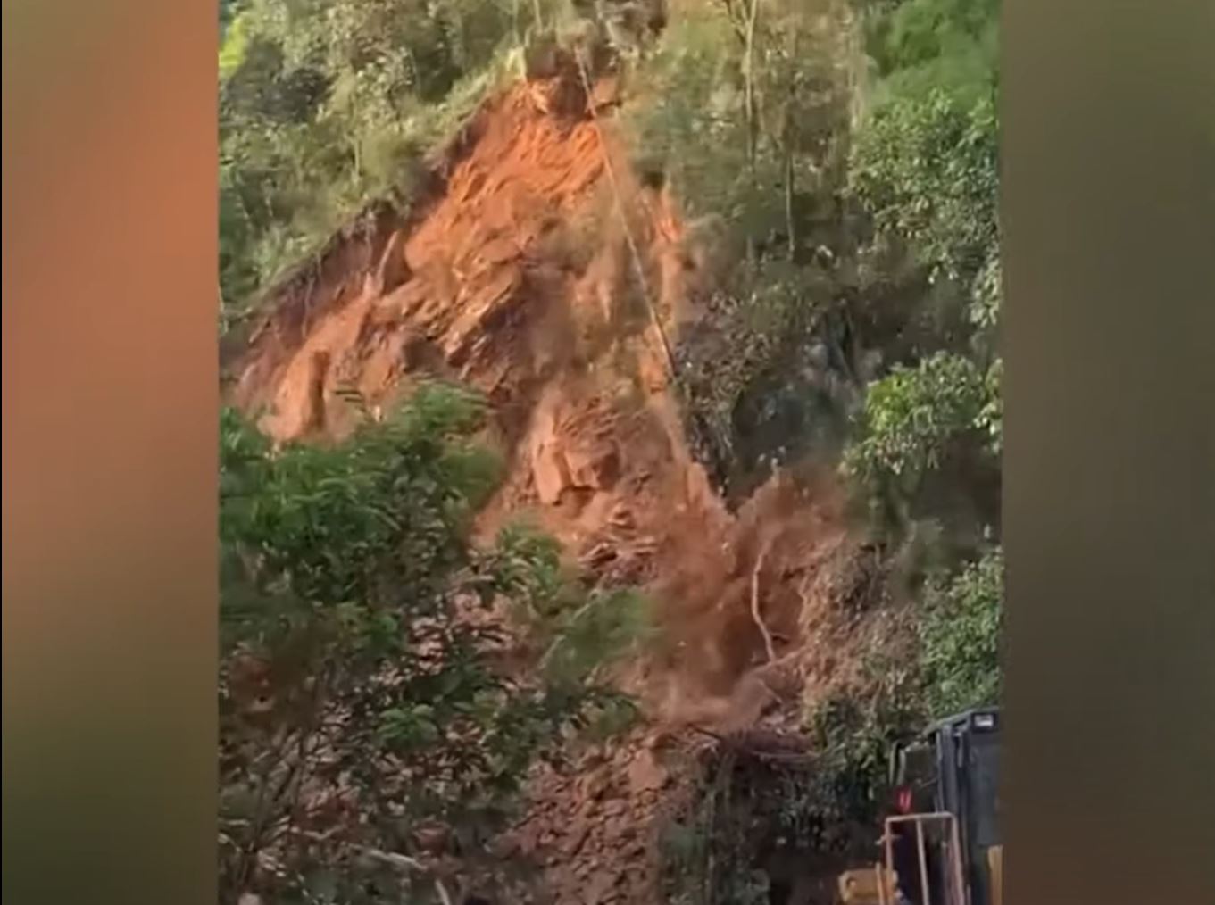
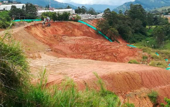
On Monday 3 May 2021 a large and interesting landslide occurred at the La Granja landfill site in La Primavera, Antioquia in Colombia. The best image (and a good report) is to be found in El Tiempo:-
The 3 May 2021 landfill landslide at Caldas in Colombia. Image via El Tiempo.
.
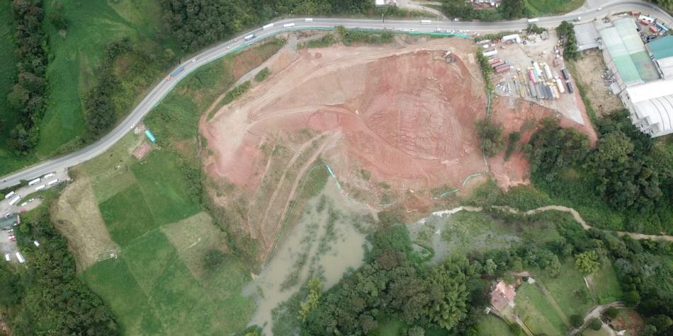
Meanwhile, El Colombiano has this image of the aftermath of the landslide:
The aftermath of the 3 May 2021 landfill landslide at Caldas in Colombia. Image via El Colombiano.
.
Note the trucks for scale in the image above.
The landslide has partially blocked the Medellín river, as the first image illustrates. The landslide at Caldas appears to be a slump – not at all unusual in landfill materials – fortunately without a high level of mobilisation. The trigger for the landslide appears to have been a spell of heavy rainfall, although erosion of the toe by the channel cannot be eliminated.
Monitoring is in place to manage the possibility of a flood downstream, but the flow in the channel appears to be quite modest.
Interestingly, the El Tiempo article has some statistics for landslides so far this year in Antioquia. DAGRAN, the Administrative Department of Risk Management of Antioquia, has recorded 56 landslide events in the rainy season so far this year (from March to the present day). In comparison, they recorded just four events in the same period last year. I wonder if this is associated with the current La Nina conditions.
Thanks to a tweet by Helbert Schneider (@HelbertSchneid1), which highlighted this event to me.
30 April 2021
Nakhon Ratchasima: a dramatic video of a rock slope collapse in a quarry in Thailand
Nakhon Ratchasima: a dramatic video of a rock slope collapse in a quarry in Thailand
A very interesting video has been published on Youtube showing a dramatic rock slope collapse of a quarry at Nakhon Ratchasima in Thailand. Information about the origin of this video is patchy – the commentary states:
A lorry slammed his foot on the reverse pedal when an entire hillside collapsed at a quarry. Several trucks were loading boulders into their containers when the land suddenly gave way in Nakhon Ratchasima, northeast Thailand. Footage shows how the 30-metre tall cliff along with several trees crashed to the ground in a cloud of dust. Drivers quickly reversed to escape from the path of the flying debris. However, it was all cleaned up and secured afterwards.
Nakhon Ratchasima is located at 14.97, 102.08, but it is a large town, so I cannot identify the location beyond this. The video should be visible below:-
.
The video starts just after the initiation of the failure:-
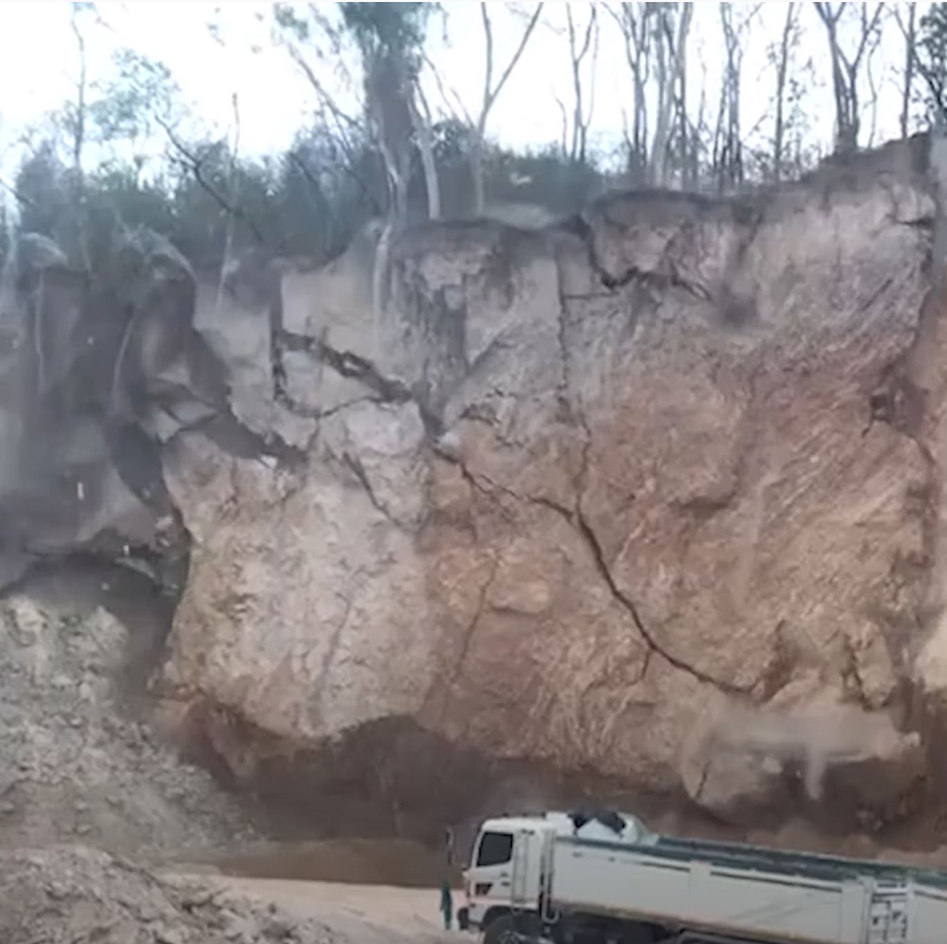
The start of the quarry failure at Nakhon Ratchasima, northeast Thailand. Still from a video posted to Youtube.
.
The collapse is a near-vertical fall, which suggests that the initiation might have been either undermining of the toe or the failure of a weak layer low on the slope. It is interesting to note how the rock mass broke up as the collapse developed:
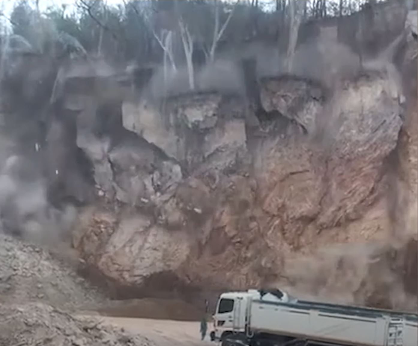
Further development of the quarry failure at Nakhon Ratchasima, northeast Thailand. Still from a video posted to Youtube.
.
The dangers posed by the failure of even a comparatively small quarry slope are very clear. It was fortunate that the truck was not close to the slope.
29 April 2021
The mining-induced Jianshanying Landslide in Guizhou Province China
The mining-induced Jianshanying Landslide in Guizhou Province China
I have frequently written about mining-induced landslides. A paper just published in the journal Landslides (Chen et al. 2021) highlights an extraordinary example, the Jianshanying Landslide, which is located in Guizhou Province in China. The landslide, which has been triggered by coal mining beneath a mountain, is located at 26.308676°, 104.734385°. It is easily seen in Google Earth imagery:-
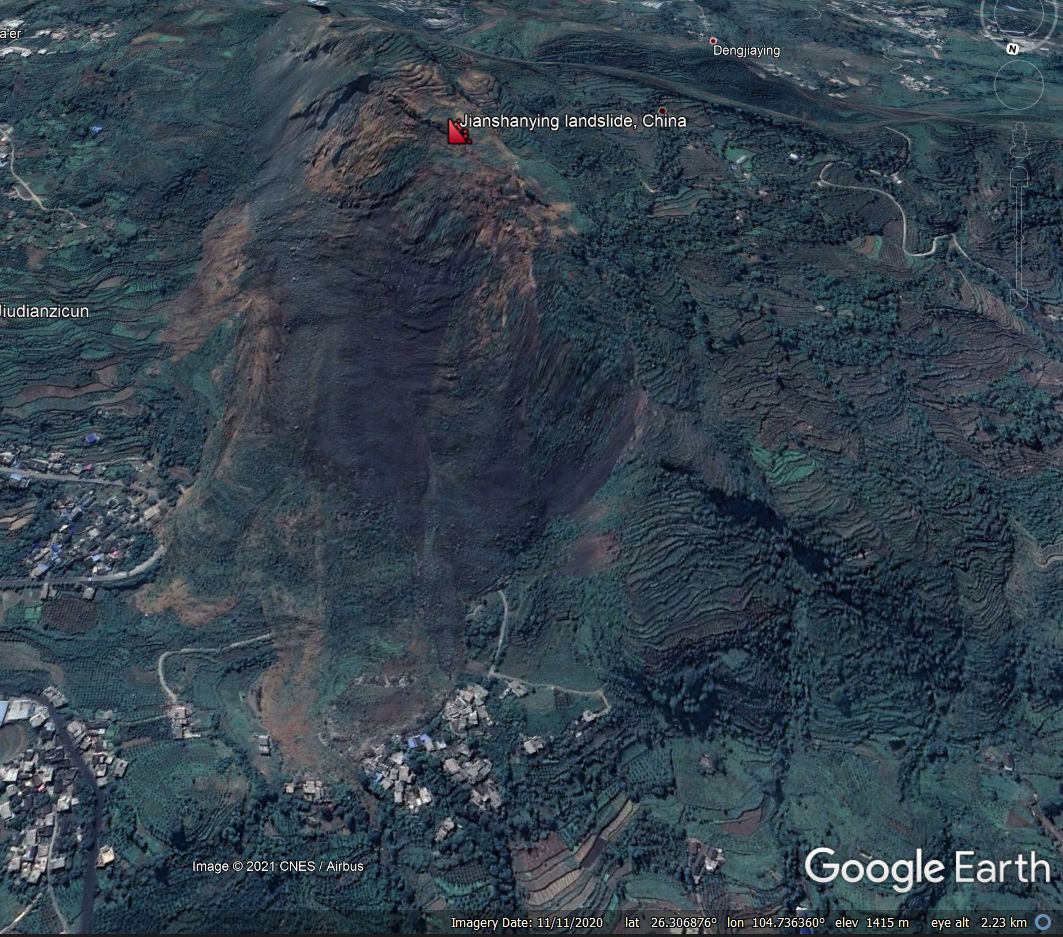
Google Earth image of the Jianshanying landslide in China.
.
This is a very large, very active failure. Note that the toe of the landslide is engulfing inhabited areas in two different locations. Chen et al. (2021) focuses on the evolution of movement of the landslide, and does a good job. They demonstrate that the landslide has rapidly evolved with time – this is also evident from the Google Earth images. The image below was collected in November 2018:-
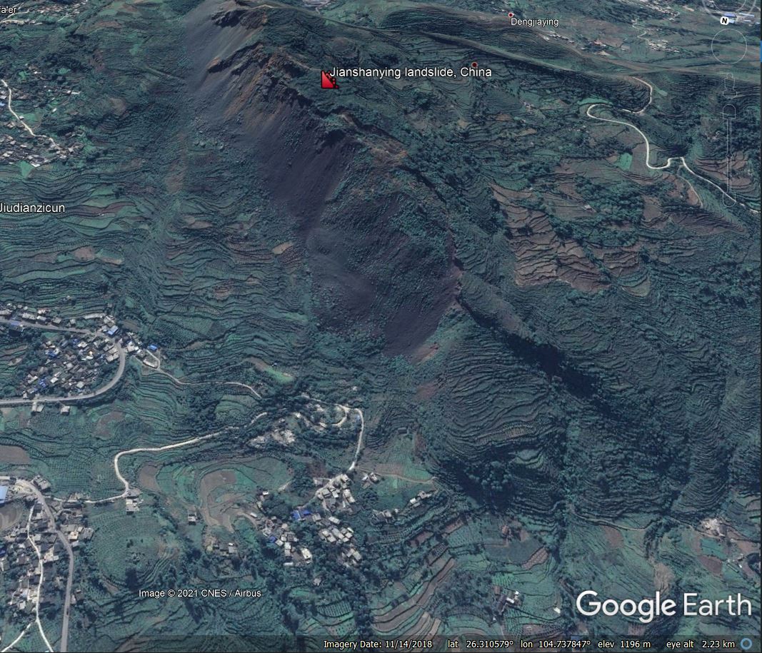
Google Earth image of the Jianshanying landslide in China in November 2018.
.
You should be able to compare these two images using the slider below. This evolution has occurred in just two years:-
[/caption].
Chen et al. (2021) have provided this very beautiful and very clear diagram to illustrate the form and evolution of the landslide:-
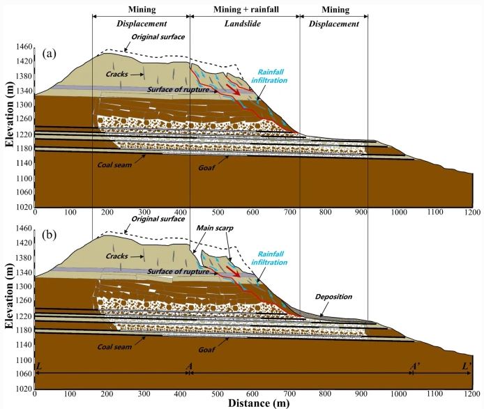
Cross-sections illustrating the form and evolution of the Jianshanying landslide in China. Figure from Chen et al. (2021).
As the cross-section shows, mining of a thick set of coal seams has induced subsidence across the whole of the mountain top, and has induced a very deep-seated failure of the flank. Movement rates accelerates in periods of heavy rainfall. The diagram infers that considerably more deformation of the landslide is yet to occur.
The crown to toe distance of this landslide is about 1,150 metres. It is about 450 metres wide. If we assume that the average depth is 25 metres (and this might be conservative) then the volume is in the order of 25 million cubic metres. As such it is one of the largest landslides triggered by mining.
.
Reference
Chen, L., Zhao, C., Li, B. et al. 2021. Deformation monitoring and failure mode research of mining-induced Jianshanying landslide in karst mountain area, China with ALOS/PALSAR-2 images. Landslides (2021). https://doi.org/10.1007/s10346-021-01678-6
27 April 2021
Great Whale River: a very large, low-angled landslide in Canada on 22 April 2021
Great Whale River: a very large, low-angled landslide in Canada on 22 April 2021
On 22 April 2021 a very large landslide occurred on the Great Whale River, upstream from the upstream of the villages of Kuujjuaraapik and Whapmagoostui in Quebec, Canada. Nunatsiaq News has this dramatic image of the landslide:-
The 22 April 2021 landslide on the Great Whale River in Quebec, Canada. Image by the Whapmagoostui First Nation, via Nunatsiaq News.
.
The landslide is located at 55.298, -77.638. It is clearly visible on the Planet Labs image taken on 23 April 2021:-

Planet Labs image of the landslide on the Great Whale River. Image copyright Planet Labs, used with permission.
.
The slide is large – from the crown to the channel it is about 1.6 km, and from the crown to the toe it is about 4 km.
The landslide is not thought to pose a direct threat to the communities downstream, fortunately, although there is some risk to users of the river as break-up of the ice is now unpredictable.
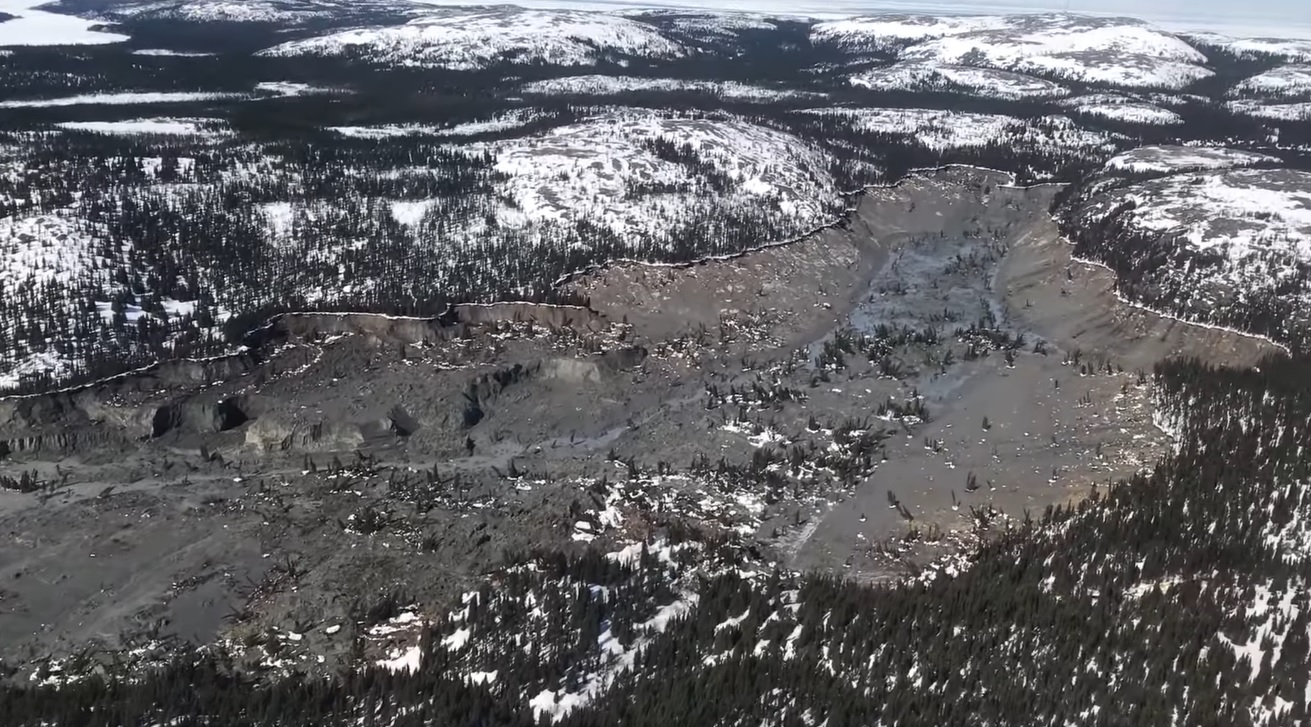
The news reports describes this as having occurred in an area of clay. The form of the landslide suggests that it could be a quick clay / sensitive clay failure. CBC has a splendid video shot from a helicopter that flew the length of the landslide. This is a still from that video:-
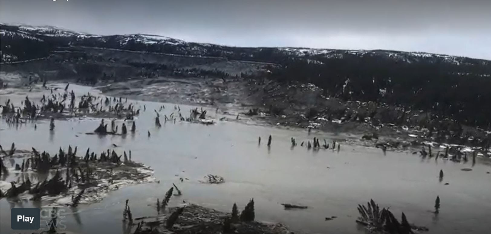
The landslide on the Great Whale River. Still from a video posted by CBC.
.
The video suggests that the downstream deposit is highly liquid mud with rafts of trees. Note that many are still standing upright. This is indicative of a quick clay landslide. The landslide itself appears to be quite deep-seated, probably reflecting a thick clay deposit. This implies that the volume of the landslide on the Great Whale River is likely to be in the millions of cubic metres.
There is little information as to the likely trigger at this point, but large landslides often occur in the spring as melt occurs.
.
Reference
Planet Team (2021). Planet Application Program Interface: In Space for Life on Earth. San Francisco, CA. https://www.planet.com/
26 April 2021
The 21 October 1993 Pantai Remis landslide in Malaysia: an upscaled video
The 21 October 1993 Pantai Remis landslide in Malaysia: an upscaled video
Early in the days of this blog I posted about an extraordinary video of a landslide in Malaysia. Almost thirteen years on this video remains hard to beat. The recording in question shows the 21 October 1993 Pantai Remis landslide in Malaysia.
This was a very unusual failure that occurred in an open cast tin mine near to the coast. Mining operations ventured too close to the sea, eventually triggering a collapse of the quarry walls. Ultimately the sea flooded the mine, creating a new cove that is still visible on Google Earth.
The video captures the collapse sequence of the Pantai Remis landslide. The failures occurred as massive rotational slides that transition into highly mobile flows through liquefaction. The mine quarry flooded catastrophically and completely. But the drawback of this video was that the quality was poor.
However, Jaren Christopher Kelley has posted a new version of the video to Youtube. This has been upscaled from the original, greatly improving the quality. You should be able to see the video below:
.
The image below shows the first rotational failure at Pantai Remis in action:-
One of the rotational failures at the 1993 Pantai Remis landslide in Malaysia. Still from a video uploaded to Youtube.
.
One of the extraordinary aspects of this video is that it is timestamped, which allows a reconstruction of the sequence of events.
This video remains hard to beat, and the new version makes it much more usable.
23 April 2021
The 13 October 2020 landslide in Phong Dien, Vietnam, triggered by an extraordinary rainfall event
The 13 October 2020 landslide in Phong Dien, Vietnam, triggered by an extraordinary rainfall event
On 13 October 2020 heavy rainfall triggered a rapid landslide at Phong Dien in Thua Thien Hue, Vietnam. I covered this event at the time – it was a double tragedy as the landslide killed 13 members of a rescue team en route to another landslide accident. A paper (Van Tien et al. 2021) has just been published in the journal Landslides that provides a description of this event.
The events started with a landslide at the construction site of the Rao Trang-3 hydropower plant on 12 October 2020. This landslide killed 17 people. A rescue team was dispatched to assist in the rescue and recovery operation. The team stopped for the night at a location that is described as Ranger Station-7, situated in Phong Dien, c.10 km from the Rao Trang-3 site.
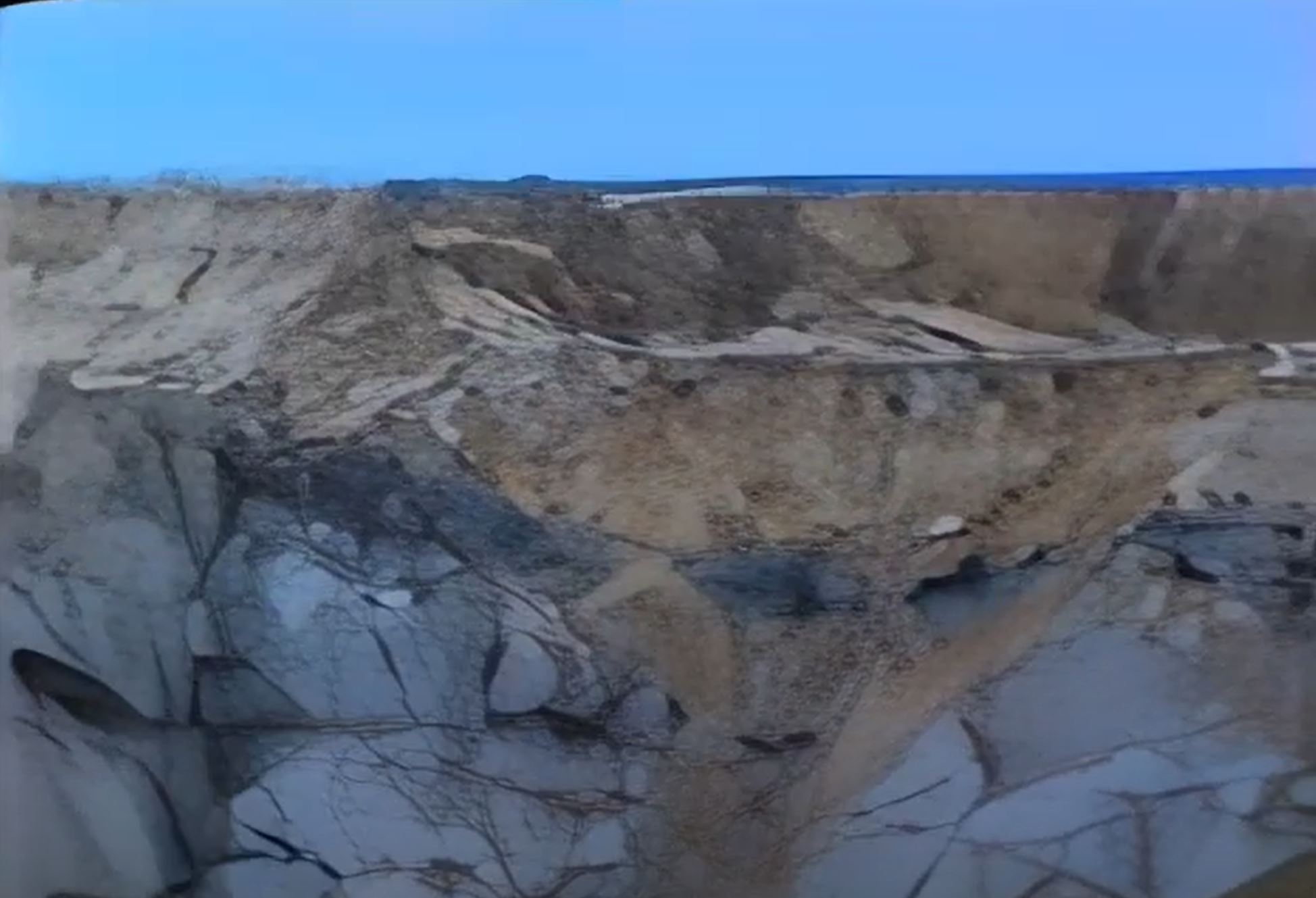
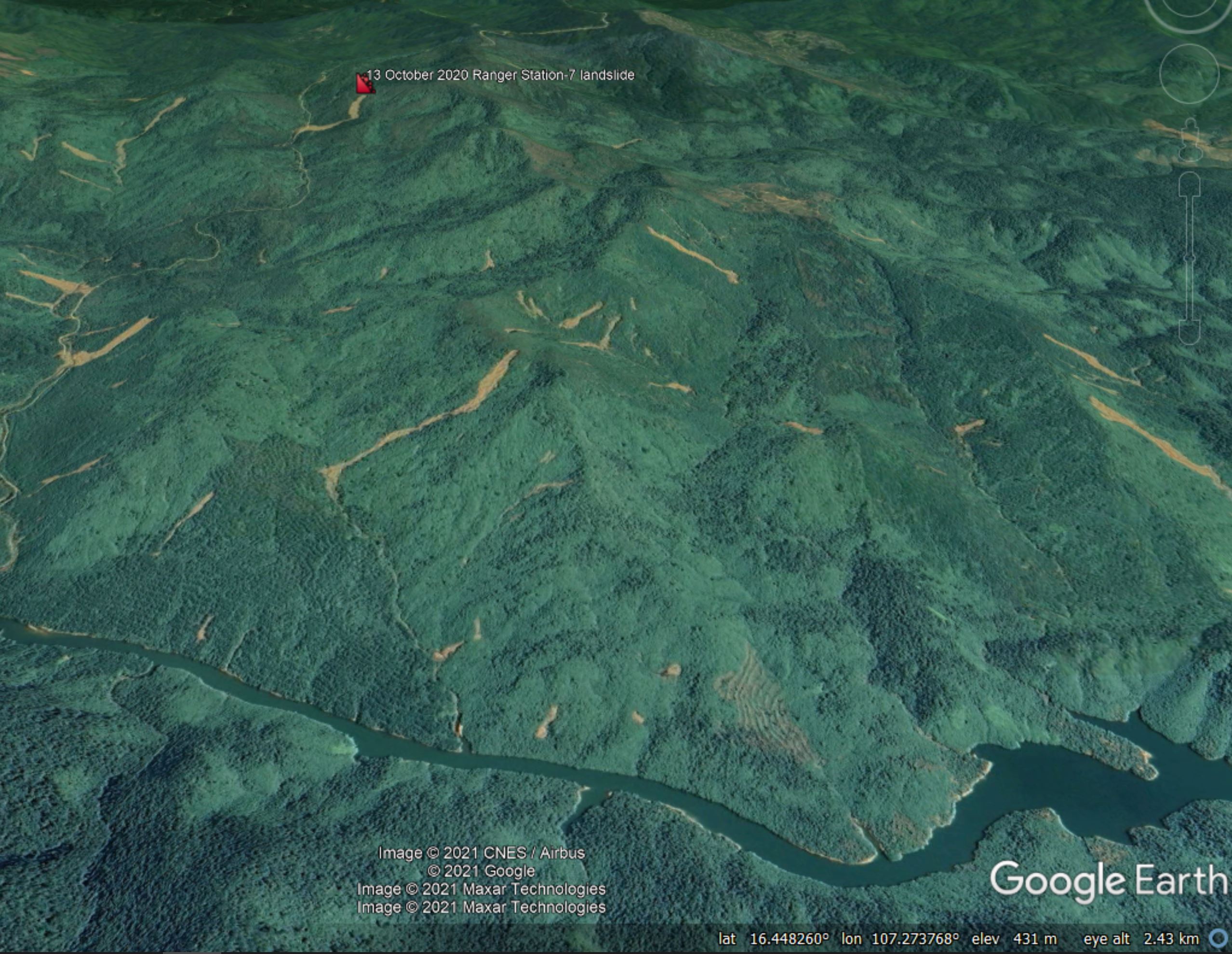
Van Tien et al. (2021) describe an extraordinary amount of rainfall. At the nearby A Luoi rainfall station, a total of 2190.2 mm was recorded in the period 6-12 October 2020. The landslide at Ranger Station-7 occurred at midnight on 13 October. The landslide is located at 16.434°, 107.311°. The Google Earth image below, collected in February 2021, shows the aftermath of the landslide:-
Google Earth image of the 13 October 2020, deadly landslide in Phong Dien, Vietnam.
.
Perhaps surprisingly, Van Tien et al. (2021) describe the initial failure, at the top of the slope, as being rotational:
The landslide was characterized as a rotational type with a visible sliding surface, head scarp, and flanks in the upper slope area. The landslide took place on an average slope of 21° with a poor vegetation cover. The lower slope is quite gentle, with an angle of 18°, while the slope angle of the upper part is 27°.
The landslide length was 546 m, with a volume of 81,500 m3.
The authors suggest that failure occurred initially in a block downslope of the final crown of the landslide – a section that they call Block I:-
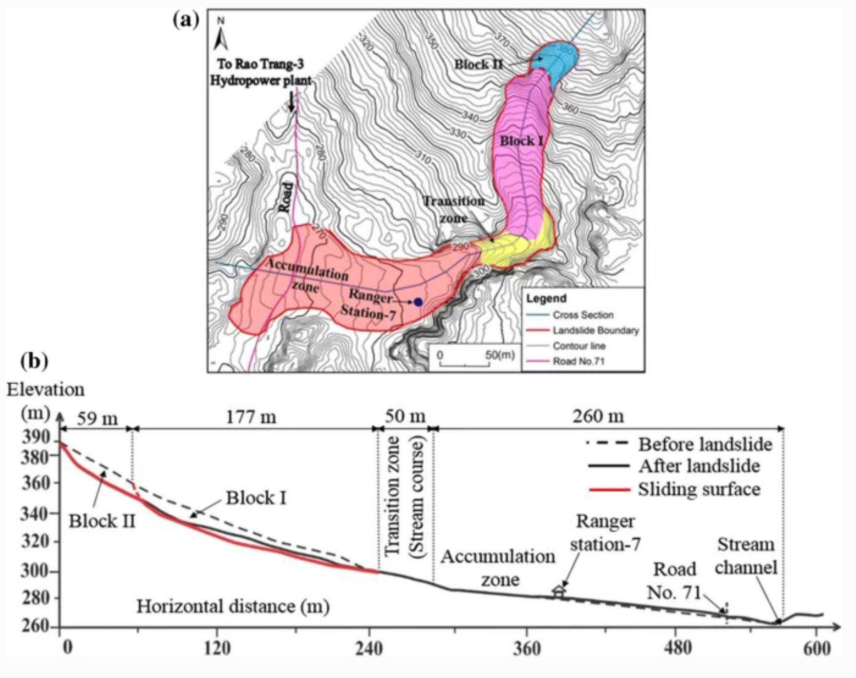
The failure process of the 13 October 2020, deadly landslide in Phong Dien, Vietnam. Diagram from Van Tien et al. (2021).
.
About 5 minutes later Block II failed due to the loss of toe support. Van Tien et al. (2021) suggest that the landslide was highly mobile, moving at 29 m/sec. Only eight of the 21 people in the Ranger Station survived, all with injuries.
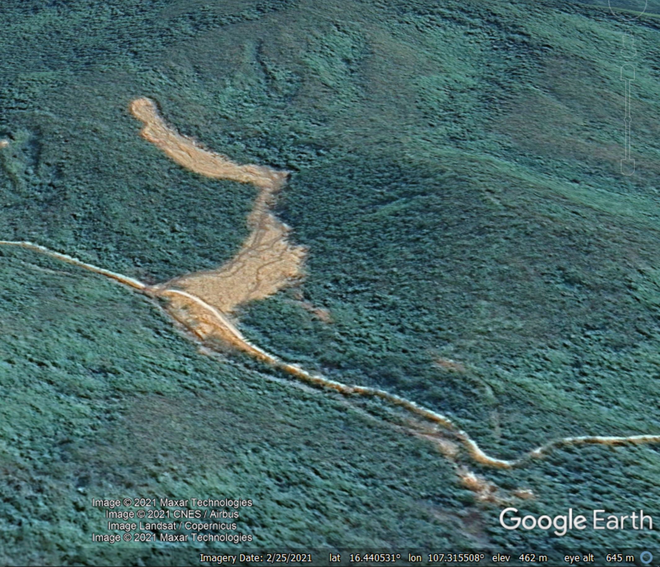
This extraordinary rainfall event triggered many other landslides in the Phong Dien area, as the image below shows. Some appear to have had quite high mobility:-
Google Earth image of landslides triggered by the October 2020 rain event in Phong Dien, Vietnam.
.
Reference
Van Tien, P., Trinh, P.T., Luong, L.H. et al. 2021. The October 13, 2020, deadly rapid landslide triggered by heavy rainfall in Phong Dien, Thua Thien Hue, Vietnam. Landslides. https://doi.org/10.1007/s10346-021-01663-z
20 April 2021
The 19 April 2021 coastal landslide at Nefyn Bay in North Wales
The 19 April 2021 coastal landslide at Nefyn Bay in North Wales
On 19 April 2021 a really interesting coastal landslide occurred at Nefyn Bay in North Wales. The BBC has some good imagery of the aftermath:-
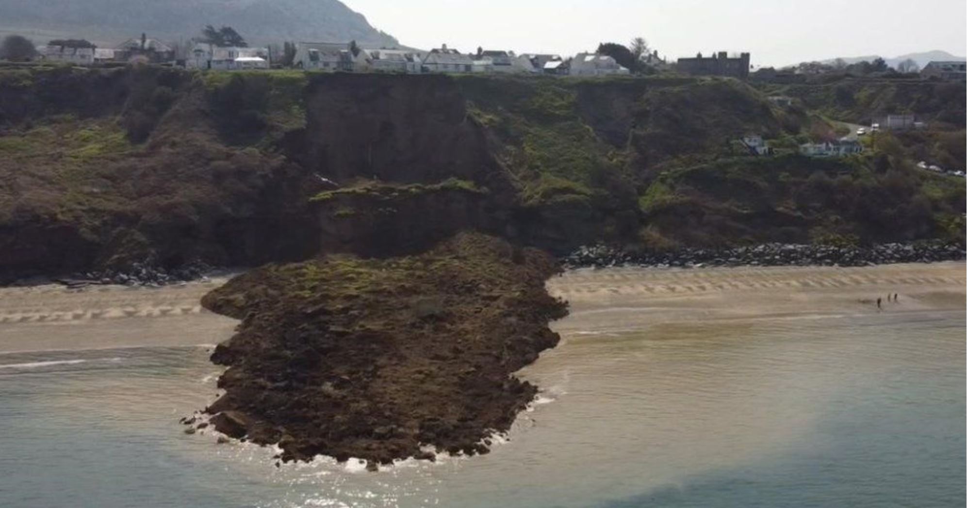
The 19 April 2021 coastal landslide at Nefyn Bay in North Wales. Image by Christian Pilling via BBC News.
.
This landslide is interesting for its timing – the UK is having a spell of unusually dry weather for April – and for its runout, which is quite long.
This landslide has received some attention in the UK, but strangely the most interesting element has not really received much publicity. This is that the landslide was captured on video by a woman, Amanda Stubbs, who was standing at the toe. It is brilliant. You should be able to see it below:-
.
The landslide starts as a small retrogressive slump on the margin of what becomes the main slide. This destabilises the main mass, which fails through a strongly rotational mechanism. After failure the mass runs across the beach as a high mobility earthflow.
There is some excellent drone imagery of the aftermath:-
Tirlithriad Nefyn 19.04.2022 pic.twitter.com/oI7y0lA2Xb
— Cai Erith Williams (@caierith) April 19, 2021
.
The imagery shows the multiple scars of previous landslides on this section of coast, so this failure comes as no surprise. The British Geological Survey (BGS) have a page dedicated to coastal landslides at Nefyn Bay, based on work undertaken after a fatal landslide on this section of coast in 2001. There is also a paper online (Jenkins et al. 2007 – one of the authors is my former PhD student Andy Gibson) that describes the nature of the landslides at the site and the evolution of the hazard. The landslides occur in glacial deposits that are eroded by the sea, exacerbated by sand layers overlying a low permeability clay.
.
Reference
Jenkins, G.O.; Gibson, A.D.; Humpage, A.J.. 2007. Climate change and evolution of landslide hazard at Nefyn Bay, North Wales. In: McInnes, Robin, (ed.) Landslides and climate change: challenges and solutions. Proceedings of the International Conference on Landslides and Climate Change. Taylor and Francis, 113-119.
 Dave Petley is the Vice-Chancellor of the University of Hull in the United Kingdom. His blog provides commentary and analysis of landslide events occurring worldwide, including the landslides themselves, latest research, and conferences and meetings.
Recent Comments