3 May 2023
A small but interesting landslide at Park City in Utah, USA
Posted by Dave Petley
A small but interesting landslide at Park City in Utah, USA
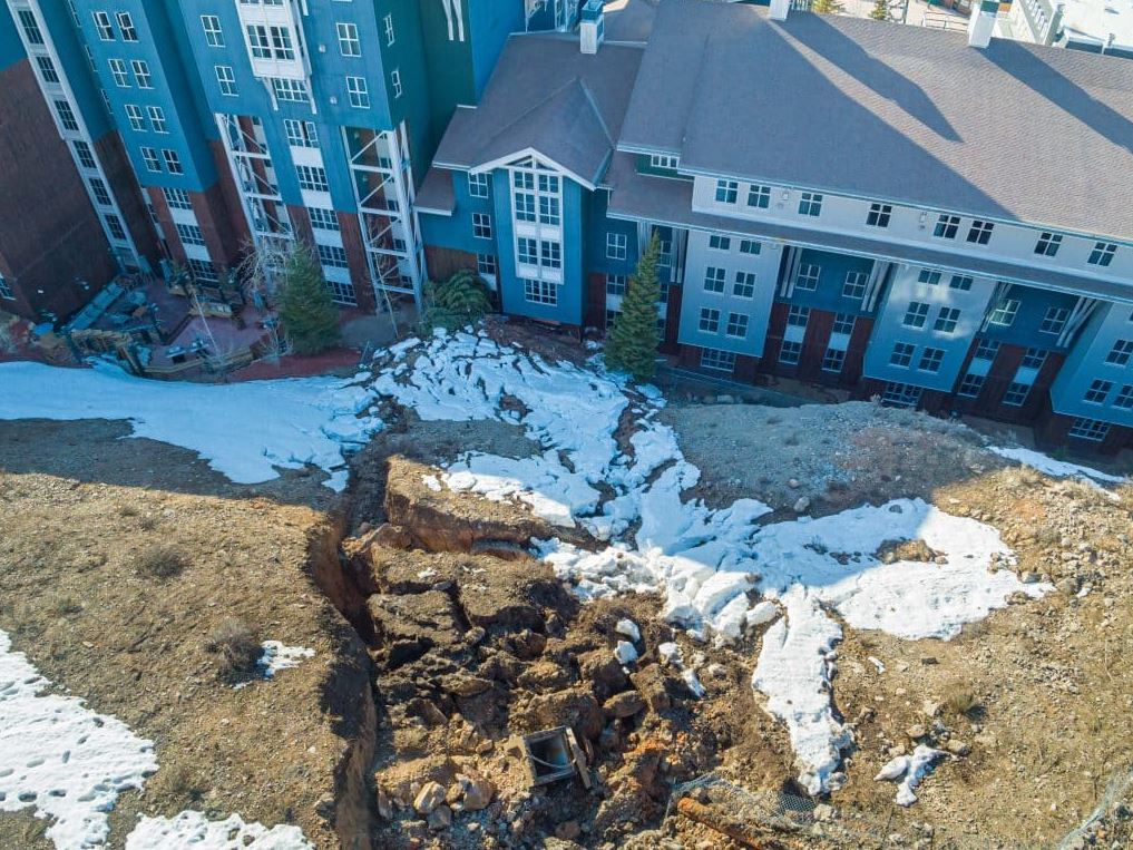
The Park Record has an interesting story about a small landslide that occurred on a slope in Park City, Utah on 30 April 2023. Recently, I highlighted that there is an expectation of a increased landslide activity in Utah this Spring. The landslide occurred on a slope above a hotel, Marriott’s MountainSide, which was reportedly damaged. This image below, from the Park Record, shows the aftermath of the event:-

The 30 April 2023 landslide at Park City in Utah. Image from the Park Record.
.
The Park Record reports that the landslide is about 30 m long, 20 m wide and 4.5 m deep.
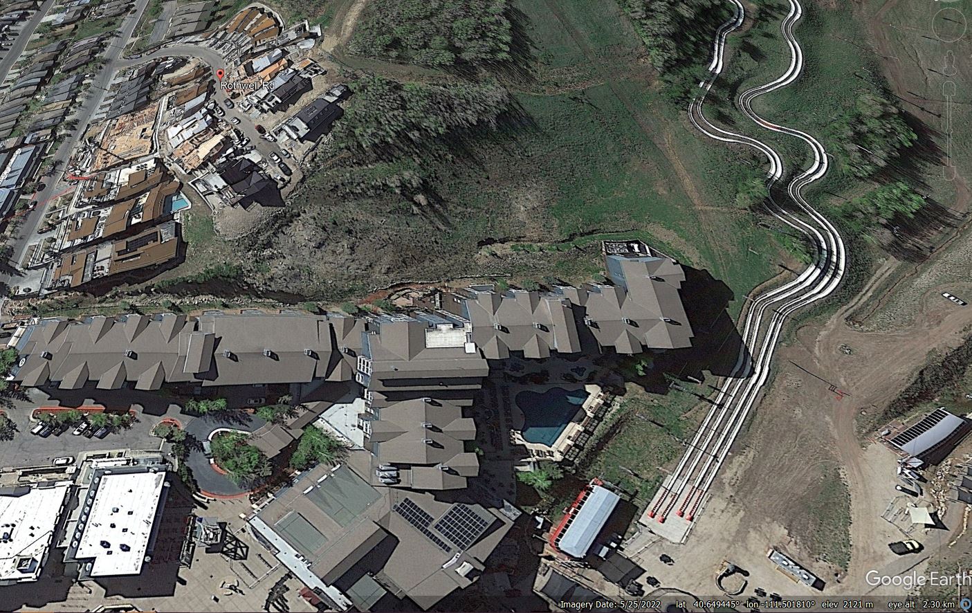
The Google Earth image below shows the site of the landslide in May 2022:-

Google Earth image from 2022 showing the site of the 30 April 2023 landslide at Park City in Utah.
.
The hotel is the large building that runs across the lower part of the image, whilst the slope that failed is in the centre of the picture. Note the construction in the upper left quarter, above the slope – this is reportedly the King’s Crown development. The Park Record notes the proximity of the crown of the landslide to the construction work, which is consistent with the debris in the first image above.
The Google Earth image suggests to me that the slope that failed may have suffered previous instability – note the hummocky topography and the apparently steep scarps towards the top of the slope. The timing of the landslide suggests that snowmelt might have played a role, especially given the unusually high volumes of snow that have fallen this winter. The role of human activity is harder to determine – did the works at the top of the slope cause increased likelihood of failure, either by disrupting the drainage or by loading the crown of the landslide? Or did cutting of the toe of the slope remove support for the soil mass? A proper geotechnical investigation is needed with some urgency.


 Dave Petley is the Vice-Chancellor of the University of Hull in the United Kingdom. His blog provides commentary and analysis of landslide events occurring worldwide, including the landslides themselves, latest research, and conferences and meetings.
A very interesting slide, very localized but ‘worrying’ in that similar slides could occur in the same area. Difficult to evaluate more without a DEM and ground investigations but a GE inspection suggests:
toe of the slide is [40.650486,-111.506774]. It looks almost like ‘made ground’ upslope and that is a very sharp left-hand side limit. I wonder if the concrete (?) shaft side and cap near the bottom centre of the slide shown in the Park Record shot is significant? I estimate that is is about [40.650429,-111.506704].
Looking back at the historical imagery I suspect that it is made ground upslope and that this has come, at least in part, from top-slope loading by the development along the new road. A site visit would make a good case study for engineering geomorphologists! and site surveyors from insurance companies!
Here is an 11 minute Youtube video of the Park City, 2023 landslide, slope map derived from and draped on 2018 USGS 1-meter DEM, NAIP aerial imagery and the NWS climate plot for Salt Lake City: https://youtu.be/qj22qi_QoBc
The 2018 1-m/px DEM and the Google Earth DEM suggest that the last 30m of the 2019 paved road may be graded -6% toward the landslide. The GE measuring tool shows that to be catchment of at least 150 square meters. We do not have the finished grade in this area. Be aware that the GE image time-series might be confused.
I wonder if there was an inspection before the start of construction, or if the landslide hazard was obvious before? Construction management is very important and needs to be accurate, so here’s a look at how you can successfully manage construction: https://fluix.io/industry-construction.
What is most interesting is what we don’t know. Buttressing effect of downslope removed? Drainage pipe excavation? Is that a box culvert in the photo?
I get the impression that there is little interest in getting to the bottom of it, not to mention other similar failures in the region.
This is a very interesting slide, albeit localized, and concerning due to the potential for similar slides in the same area. More detailed evaluation is challenging without a Digital Elevation Model (DEM) and thorough ground investigations. However, a Google Earth inspection indicates where the toe of the slide is located. The upslope area appears to be almost like ‘made ground,’ and there is a notably sharp left-hand boundary. The presence of what seems to be a concrete shaft side and cap near the bottom center of the slide, as depicted in the Park Record photograph, might be significant and worth further investigation. Elementmajad