
25 July 2023
The location of the 20 July 2023 debris flow at Ungar in Lhuentse, Bhutan
Posted by Dave Petley
The location of the 20 July 2023 debris flow at Ungar in Lhuentse, Bhutan
Yesterday, I posted about a debris flow disaster that occurred on 20 July 2023 at Ungar (also spelt Unger and Unngar) in Bhutan, which is believed to have killed 23 people. Dr Stuart Dunning (@Rock_Avalanches) of the Newcastle University tweeted (or is that Xeeted?) a possible location for the accident, based upon Planet Labs images:-
Ungar, Bhutan debris flow @davepetley ? Right is June, left is July 22nd @KuenselOnline @glof_Sonam pic.twitter.com/CjQErRNXEs
— Stuart Dunning (@Rock_Avalanches) July 24, 2023
.
This location is [27.57095, 91.07595]. Looking at the photographs of the site, I think that this is indeed the location. This is a Planet image of the site collected on 15 July 2023:-
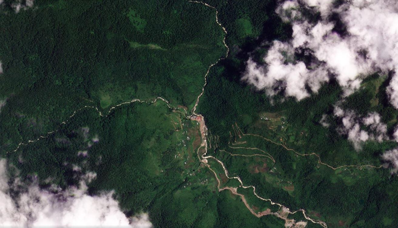
The site of the 20th July 2023 debris flow at Ungar in Bhutan. Image copyright Planet, used with permission. Image dated 15 July 2023.
.
This is an image collected on 22 July 2023, showing the aftermath of the debris flow:-
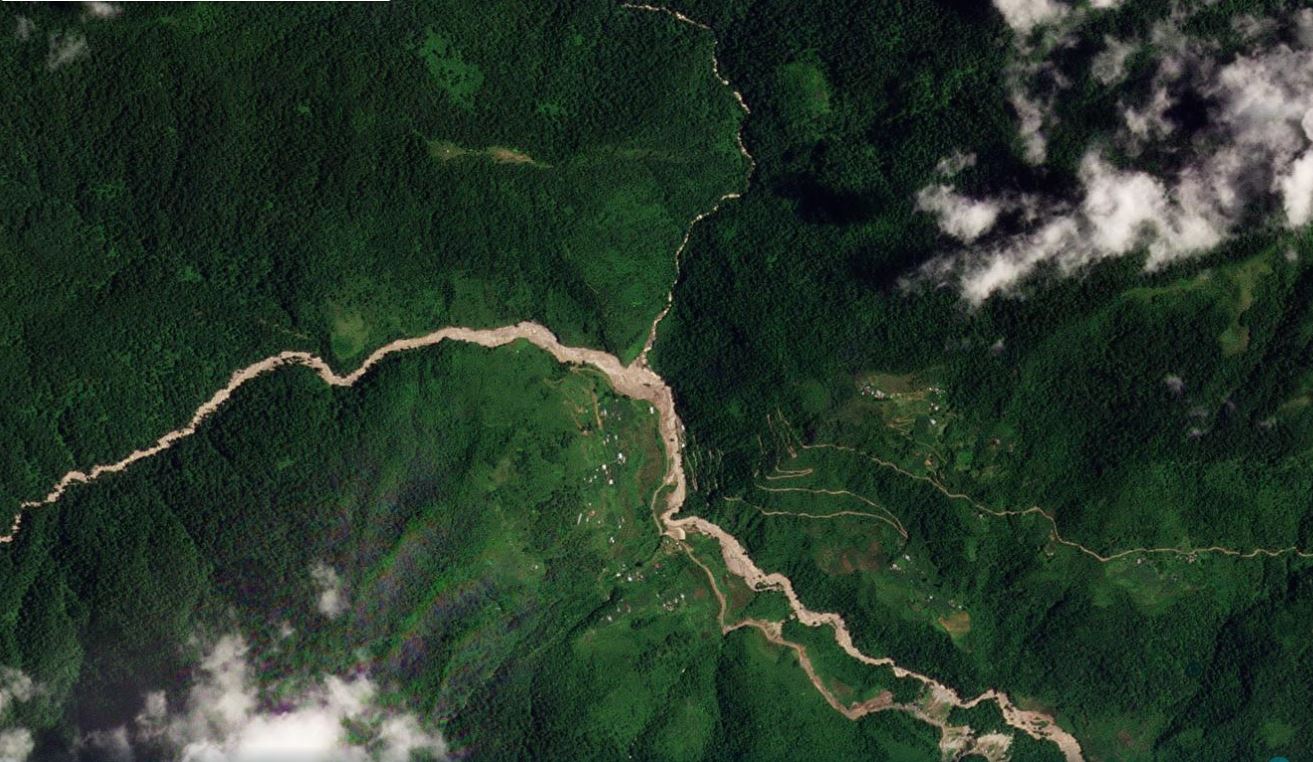
The aftermath of the 20th July 2023 debris flow at Ungar in Bhutan. Image copyright Planet, used with permission. Image dated 22 July 2023.
.
Below is a slider that should allow you to compare the two images:
.
In the image before the disaster, there appears to be a set of structures in the channel immediately below the confluence of the two tributaries. In the image after the debris flow, these structures have clearly been destroyed. The decision to locate a camp, if that is what happened, in such a vulnerable position is interesting. As I noted previously, there are multiple examples in which landslide hazard has not been properly considered in hydroelectric schemes in the Himalayas.
The source area for the debris flow, to the west of the images above, is shrouded in cloud in the images since the accident. However, this is what the catchment looks like on Google Earth – the pin is the location of the camp:-
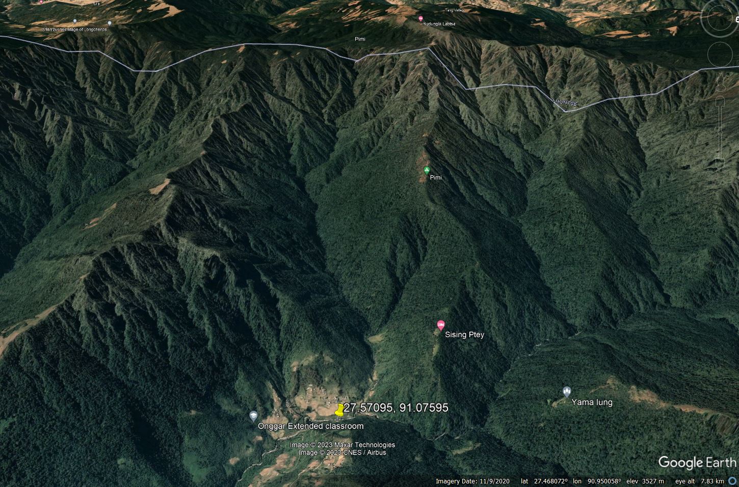
Google Earth image showing the catchment of the 20 July 2023 debris flow at Ungar in Bhutan.
.
This is clearly a very steep, dissected landscape, with multiple small tributaries feeding into the main channel. This is a classic for landscape for small slips combining to create a channelised debris flow. Unfortunately, cloud free images may not become available until the end of the monsoon.
.
Acknowledgement
Planet Team (2023). Planet Application Program Interface: In Space for Life on Earth. San Francisco, CA. https://www.planet.com/
 Dave Petley is the Vice-Chancellor of the University of Hull in the United Kingdom. His blog provides commentary and analysis of landslide events occurring worldwide, including the landslides themselves, latest research, and conferences and meetings.
Opps I put this comment on the previous post by mistake, feel free to delete that one 😛
There’s a place much further down the valley than this, which is marked as the Yungichu Hydroproject Campsite on Google maps ( 27.526185°, 91.128159°) . You can see the same bridge that’s in the Photo (orientated in the same way to the river, along with the roadway matching up with the one seen in the photo). I’m thinking the confusion comes from the Buildings in the background. Newest pic is dated 12/26/2020. So it’s possible that they have been built, and the land cleared, in the last couple of years
[That is the location I highlighted in my first post, but I don’t think it is the right one. The photograph shows farmland and houses on the slope behind, which are not shown in the Google Earth image. These can be seen in the location in this post. D.]