
13 October 2016
Nepal landslides 2016: losses at the end of the rainy season
Nepal landslides 2016
As the rainy season comes to an end in Nepal, it is now possible to assess the impact of landslides across the country. As usual I have been compiling statistics on landslide impacts in terms of loss of life; I have this data back to 1980. I had anticipated that 2016 might be a bad year given the continued unconstrained development of poorly engineered roads and other structures in the Hill Districts, and the after effects of the 2015 earthquake.
The outcome is interesting. In terms of landslide events that caused loss of life (and excluding the 2015 earthquake, which triggered many landslides), 2016 was the worst year in my dataset – i.e. the worst for at least 36 years. I have recorded 61 fatal landslide events in 2016, whereas the previous worst year was 2002 with 58 events, and then 2009 with 49. However, in terms of loss of life 2016 did not set any records, which is good. I have recorded 184 fatalities (a number that is of course far too high). The record is still 2002 with 342 deaths, and the toll was higher than that of 2016 in 2001, 2003, 2014 and 2015 (excluding the earthquake). This reflects the lack of events that kill large numbers of people at once; 2016 seems to have been characterised by large numbers of smaller events rather than small numbers of very large events.
This is the updated graph of the number of fatalities per year since 1980:
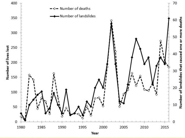
Nepal landslides 2016: The number of fatal landslides and the number of deaths per year in Nepal since 1980
.

Nepal landslides 2016: Cumulative totals of the number of fatal landslides and the number of deaths per year in Nepal since 1980
.
As you can see 2016 does stand out as an exceptional year in terms of numbers of landslide events. The overall trend in landslide losses over the last 10 years remains strongly linear, suggesting that we are getting no better (but also no worse) at reducing landslide losses in the country:

Nepal landslides 2016: cumulative losses over the last decade
.
Nepal landslides 2016: Other posts that might be of interest
- Taplejung: another burst of fatal landslides in Nepal
- Monsoon 2016: Nepal reels under the effects of multiple landslides
- Live landslide monitoring data from Nepal
- Araniko Highway in Nepal: landslide problems in the monsoon
- The timing of the landslide season in Nepal
- Continuing landslide turmoil in Nepal
- The Seti River landslide disaster in Nepal: two years on
- Fatal landslides in Nepal in 2012
11 October 2016
The Sucun landslide: missed opportunities to protect the village
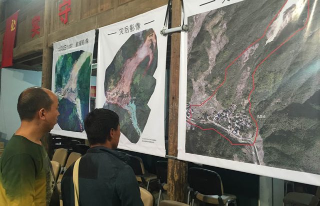
The Sucun landslide: “In the wake of a deadly landslide, residents look at ‘before’ and ‘after’ satellite images of Su Village, Zhejiang province, Oct. 8, 2016”. Note the clear landslide scar above the village on the image to the right. Via The Sixth Tone
.
The Sucun landslide
It is now clear that the Sucun landslide in Zhejiang Province, China killed 27 people. Last week I used archive Google Earth imagery to show that this was a location with a clearly identifiable landslide problem, and that the landslides had been getting progressively worse. The Sixth Tone, a progressive publication in China, has a pair of really interesting articles about the landslide, and the in particular the missed opportunities to prevent the final disaster. The first article illustrates rather nicely the way that hazard can become normalised in the minds of the population:
Landslides are a common occurrence in Su Village, Lower Su resident Wang Xiaoqin, 45, told Sixth Tone. Usually it’s just a few rocks rolling down the mountain and nobody gets hurt. The local resident said that’s why few people heeded the warning when village officials told residents at noon on Wednesday that there was the possibility of a landslide, and that they should move away.
For most people, rocks rolling down the mountain would be taken as a warning sign. But if that occurs in every rainfall event then it becomes normal, and so the population becomes less likely to relocate. Sadly of course, small rockfalls can be the precursor to a major failure.
The second article looks in more detail at the known hazards at this site, and the missed opportunities to relocate. It is, with hindsight, a woeful tale:
The disaster, however, wasn’t a total surprise: The village was known to be at risk, but plans to avoid danger were either badly implemented or shelved repeatedly.
And
But the villagers knew they were living in a dangerous area. Several government initiatives have been drawn up over the years to move at least part of Su Village to safer ground. Su Zengmin, party secretary for Su Village from 1985 to 2008, told Sixth Tone that since 2006 smaller landslides became a frequent occurrence on rainy days. They reported the issue higher-up, and in 2009 the Suichang County government announced a plan to move the primary school in the village — located in the safer Lower Su — and auction off the land so villagers living in risky areas could build new houses there.
And
In 2011, the land and resources bureau of Suichang County published an official document on strengthening prevention and control of natural disasters. It said that some 300 people from four villages, including Su, were to be relocated to avoid geological incidents that would result in heavy casualties. State news agency Xinhua reported a day after the landslide that the county government had listed Su Village as part of a relocation project three years in a row, beginning in 2013, but that the plans were never implemented. The document describing the plans was deleted from the government’s website following the landslide.
This is not an unusual set of events. Relocation of communities is a very fraught problem, but the images suggest that the hazards posed by the potential Sucun landslide were so clear that the failure to move the village is hard to fathom.
Of course, the difficulties in understanding landslide hazard are not solely a problem in China. Over the last two days two legal settlements have been reached in the Oso landslide in Washington State three years ago, which killed 43 people. The State of Washington has agreed a settlement of $50 million and the local timber company, Grandy Lake Forest Associates, agreed a settlement of $10 million. The defense was also ordered to pay $789,000 in punitive damages because expert witnesses deleted key emails whilst preparing their evidence.
Other posts that may be of interest:
- The Sucun Village landslide in China and prospects for landslides in Haiti from Hurricane Matthew
- Landslides from typhoon Megi in Taiwan
- Oso landslide: a new video five minutes after failure
- Oso: The SR 530 Landslide Commission report
- The Oso (Steelhead) landslide in Washington State – could it have been foreseen?
10 October 2016
Meru Volcano, Tanzania: the largest known continental debris avalanche
Meru Volcano, Tanzania
Meru is a 4565 m high volcano located on the East African Rift in Tanzania. In a paper just published online in Landslides, Delcamp et al (2016) examine an enormous debris avalanche deposit, known as Momella, that was formed when the the eastern flank of the volcano collapsed about 9000 years ago. The horseshoe-shaped scar of this collapse event is very evident on Google Earth:
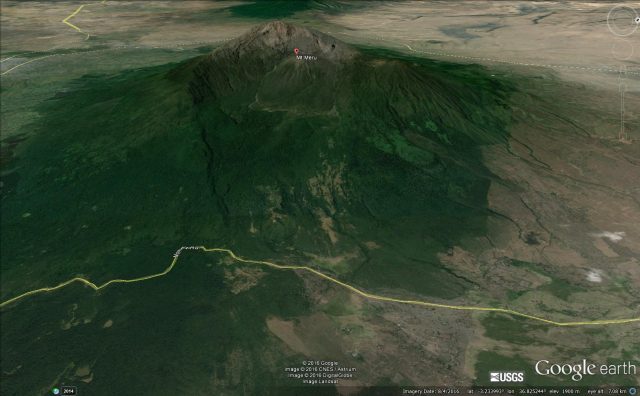
Google Earth oblique image of Mount Meru showing the horseshoe shaped scar on the eastern side
.
The collapse event was truly epic. The paper attempts to determine the volume of the debris flow deposit, and concludes that it was about 20 cubic kilometres – that is 20 billion cubic metres or about 55 billion tonnes of rock. To put that in perspective, if the debris were piled onto a plot the size of an average city block (about 10,000 square metres), the pile would be 2000 kilometres high! The deposit covers an area of about 1250 square kilometres, as shown in this map from the paper. I have put a Google Earth image alongside for comparison:
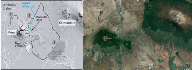
The Meru Volcano debris avalanche deposit from Delcamp et al. (2016) alongside a Google Earth image of the area
.
As the map shows, the enormous Momella landslide deposit is not the only one in the vicinity of Meru volcano – indeed there are at least two others, although these are smaller. According to Delcamp et al (2016), the Momella landslide had a fall height of 3.4 km and a runout distance of 49 kilometres, giving it exceptional mobility. Interestingly, the paper suggests that the presence of water probably played a key role in the exceptional mobility of the landslide.
This is another example of these most enormous and catastrophic of all landslides. Such events are exceptionally difficult to study because of the huge area that they cover, and the difficulty of obtaining good outcrops of the deposit. I think this particular example is probably not widely known, so this new, impressive, paper is most welcome.
Reference
Delcamp, A., Kervyn, M., Benbakkar, M., Kwelwa, S. and Peter, D. 2016. Large volcanic landslide and debris avalanche deposit at Meru, Tanzania. Landslides (2016). doi:10.1007/s10346-016-0757-8
Other posts that may be of interest
- Rockfalls shaking a volcanic lava dome apart (including a dramatic video)
- Geological evidence for a large landslide in Tenerife
- Volcanic landslide in the Democratic Republic of Congo
- The Casita landslide revisited
- Volcanic flank collapse and tsunamis
7 October 2016
Landslides in Art Part 28: Cantata Memoria – in memory of the Aberfan Disaster

Cantata Memoria by Karl Jenkins
Cantata Memoria, in memory of the Aberfan Disaster
Later this month will mark the 50th Anniversary of the Aberfan Disaster in South Wales, the worst landslide disaster in British history and an event that has left an indelible scar on a generation. In brief summary, on 21st October 1966 a spoil heap of coal waste failed above the village of Aberfan. The resulting flowslide struck the village, and in particular the school, killing 116 children and 28 adults. Clearly I will post again on this topic in the fortnight ahead, and of course I posted about it five years ago. To mark the anniversary, the composer Karl Jenkins has written a new piece entitled Cantata Memoria. This is released by Deutsche Grammaphon today an\d will be premiered at a concert in the Wales Millennium Centre in Cardiff tomorrow.
Last Saturday, the Guardian ran a piece that provided some background to the composition of Cantata Memorium. The article is worth a read – in this extract Karl Jenkins explains the thinking behind the work:
Cantata Memoria: For the Children/Er Mwyn y Plant is both music and a poem. It is not a documentary, nor even a dramatisation, but it does include a conflation of ideas and facts that are by now part of the legacy. There wasn’t just one cortège (the title of a movement), but we do know that “All Things Bright and Beautiful” was sung at Pantglas School from time to time. A poignant line in the hymn has sinister ambiguity in our context as the “rivers running by” alludes to the hidden river running underneath the village that contributed to the disaster. The Welsh song “Myfanwy” (written by Joseph Parry from nearby Merthyr Tydfil and also quoted) was sung by the soldiers who dug for victims. “Myfanwy” was also the first piece performed by the local Ynysowen Male Choir, formed after the tragedy, and from which the community sought to find some solace.
The text is multilingual: English, Welsh and Latin (from the Mass), while also referencing words in many other languages which, it is hoped, symbolise how this memorial is at once both specific and universal.
Cantata Memoria, sung by Bryn Terfel among others, is in two distinct sections but performed continuously. The first deals with the disaster and its immediate aftermath, and the second moves from darkness to light, reliving memories and celebrating childhood.
There is a an extract of the work on the Classic FM website, and it should be viewable below:
.
It is haunting to the degree of being almost painful to me. It is a wonderfully fitting memorial to this most outrageous tragedy. It sits beautifully alongside the work by Laura Siersema, also written to remember the tragedy.
Other posts that may be of interest
- Landslides in Art Part 22: Aberfan (7 pianos, percussion, voice and tools of rescue)
- Remembering the Aberfan disaster – 45 years ago today
- Landslides in Art part 27: Louise Collis
- Landslides in Art Part 26: Robyn Collier
- Landslides in Art Part 25: Richard Humphrey
- Landslides in Art Part 24 – Mary Buckland
- Landslides in Art Part 23: Marzia Colonna
6 October 2016
Liukuo Hot Spring: a major landslide on the Southern Cross Island Highway in Taiwan
Liukuo Hot Spring landslide
Earlier this week the Southern Cross Island Highway in Taiwan, one of only a small number of roads that cross the Central Mountains of Taiwan, suffered a major landslide at Liukou Hot Spring. This event was captured on a fairly dramatic video by road users. The video is contained within this PTS News report:
.
PTS News has a nice article about the landslide and its impacts, which indicates that about 150 metres of the road has been lost. The report also contains some nice drone images of the landslide that demonstrate its size:
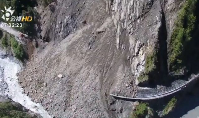
Landslide on the Southern Cross Island Highway in Taiwan at Liukou Hot Spring, via PTS News
.
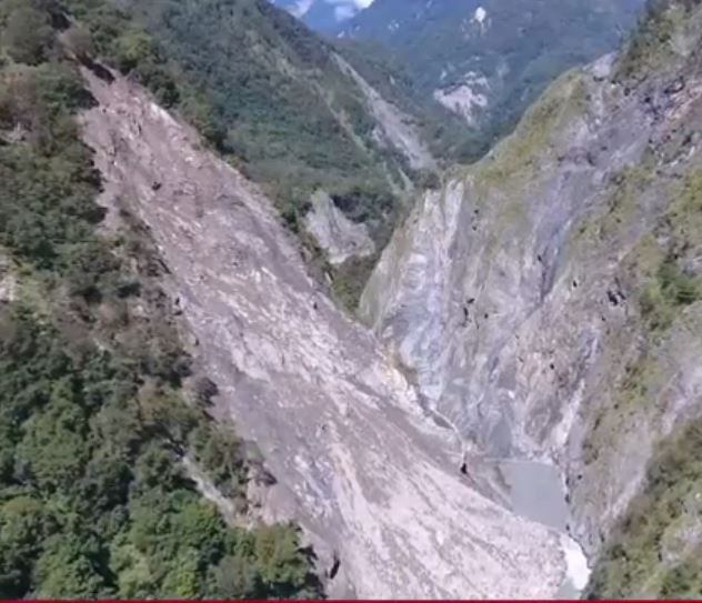
A landslide on the Southern Cross Island Highway at Liukou Hot Spring, via PTS News
.
The Southern Cross Island Highway in Taiwan is probably one of the most landslide-prone roads on Earth. Despite working in Taiwan for 25 years I have never yet managed a successful traverse without the way being blocked by a landslide. This Google Earth image illustrates the magnitude of the challenges:
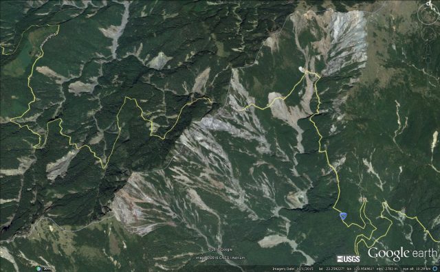
Google Earth image of the central portion of the Southern Cross Island Highway in Taiwan
.
Many of these landslides were triggered by Typhoon Morakot in 2009. Keeping this road open is a major challenge, but it is an essential access route for communities located in the mountains. That it is open at all is a testament to the engineers.
Similar posts that may be of interest
- Breaking news? Hundreds missing in Taiwan landslides after Typhoon Morakot?
- Typhoon Morakot mudslides: Before and after photos of Shiaolin (Hsiao-lin) village in Taiwan
- Eyewitness account of landslides triggered by Typhoon Morakot in Taiwan
- After Morakot
- Without doubt the most amazing landslide of the year so far – Pingtung County, Taiwan
- Landslides from typhoon Megi in Taiwan
- The mechanism of the Highway 3 landslide in Taiwan
- Images of the Highway 3 landslide in Taiwan
5 October 2016
Aletsch: a major developing post-glacial rockslide
Aletsch: a major developing glacial rockslide
Both Juy Bullot and Eric Bardou (many thanks to them) have alerted me to a very interesting major rockslide developing in the Aletsch region of Switzerland. Reports about the slide are only in French as far as I can tell, but this is a most interesting landslide.
The slide itself is at Moosfluh in the Riederalp, Canton du Valais, above the left flank if the Aletsch Glacier. This is a Google Earth image of the site, although note that the image is seven years old:
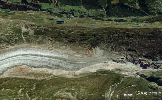
Google Earth imagery from 2009 of the site of the Aletsch landslide in Switzerland
.
Le Nouvelliste has a brief article on the landslide (in French of course). this is my translation, with help from Google because I’m lazy!,:
A landslide in Moosfluh on the left bank of the Aletsch glacier has greatly accelerated in recent weeks. The hiking trails in the sector have been closed by the municipality of Riederalp with support from the canton. Numerous cracks and a few rockfalls have been observed at Moosfluh on the left bank of the Aletsch glacier. The phenomenon is being monitored in detail. The area concerned is about 1 square kilometre. The moving mass has a volume of more than 200 million cubic metres and is moving more than 20 cm per day.
A rapid collapse of the entire mass seems at this stage very unlikely.
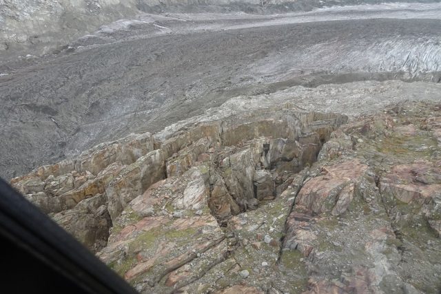
They have this image of the site:
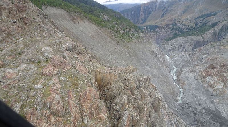
Image of the developing landslide at Aletsch in Switzerland, via Etat Du Valais and Le Nouvelliste
.
Rhone FM has a view from a different angle:
An image of the Aletsch landslide, via Rhone FM
.
This is a wonderful opportunity to study the development of progressive failure in a large rockslope. Predicting the time of failure is fraught with difficulty, and it is good that no bold forecasts are being made at this stage. A particularly interesting aspect of this landslide is that its location is close to the terminus of the retreating Aletsch Glacier. Wikipedia reports that in some years this glacier is retreating at 100 m per year. It has long been hypothesised that major rockslides may be more likely when slopes are debuttressed by glacial retreat. That may be the case here.
Other posts on a similar topic
- Glacier Bay Landslide in Alaska: a satellite image and new videos
- Lamplugh Glacier rock avalanche: A massive new landslide in Alaska on Tuesday
- The Tyndall Glacier landslide: images from the University of Alaska Fairbanks
- The Tyndall Glacier landslide in Alaska: the largest recorded non-volcanic landslide in North America
- Dariali Gorge: another very large landslide from the Devdoraki glacier
- The Siachen Glacier avalanche (138 people killed) was an ice-rock avalanche
4 October 2016
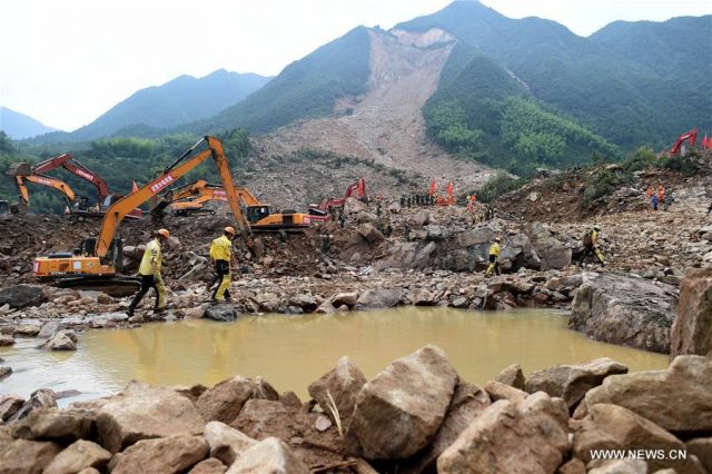
The Sucun Village landslide in China and prospects for landslides in Haiti from Hurricane Matthew
The Sucun Village landslide in China
On Wednesday of last week a major mass movement, the Sucun Village landslide, was triggered by rainfall brought by typhoon Megi in Zheiang Province, eastern China. The landslide was in part captured in a remarkable video, although the clarity of the images is not particularly high. The amount of dust that this landslide generated is quite interesting.
.
Interestingly, the second part of this news report also appears to have a video of the landslide from a different angle:
.
The best image of the Sucun Village landslide that I have seen is this one, from JSChina:
The Sucun Village landslide in Zhejiang Province, eastern China, via JSChina and English.news.cn
.
According to Xinhua:
“Rainstorms triggered by Typhoon Megi caused about 350,000 cubic meters of debris to slide down nearby mountains, burying 20 houses in Sucun Village, Suichang County on Wednesday. More than 1,460 residents living nearby have been evacuated.”
I tracked the location of the landslide down to 28.778 N, 119.300 E, a location that has an excellent Google Earth image from 2013:
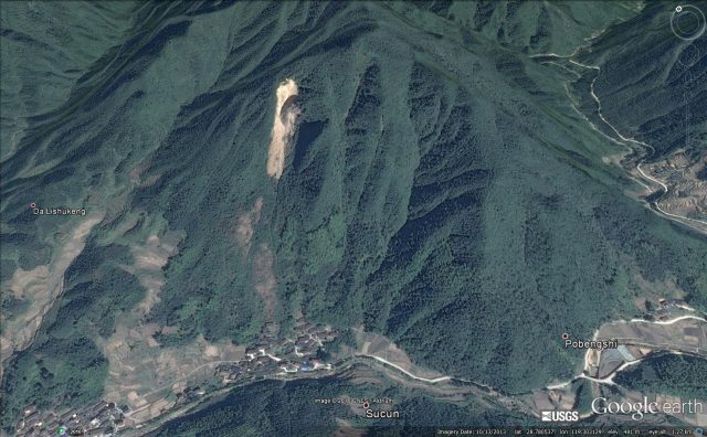
Google Earth image from 2013 showing the location of the Sucun village landslide in China
.
The key feature here needs no explanation of course – the site of the landslide had an active slide, perched high above the village, in 2013. Note the areas bare of vegetation between the slide and the town – close inspection suggests that these are areas of rockfall deposits. Note how close they are to the village:
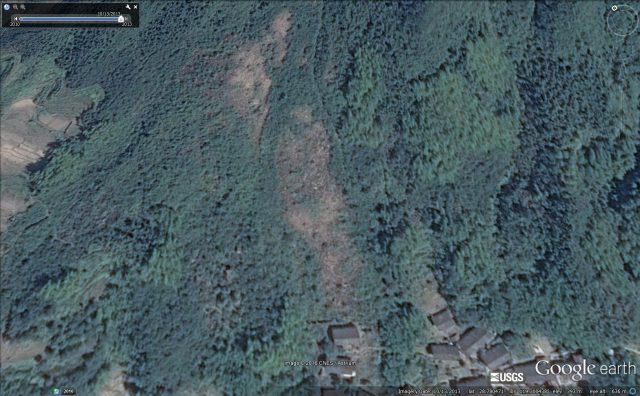
An area of colluvium above the village at the site of teh Sucun landslide in China
.
The most depressing aspect of this landslide is the obvious progression to failure that the images display. This is the Google Earth image from 2010 – compare it with the one three years later. It is clear that the slope had evolved considerably. This should have been a warning sign:
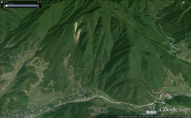
The location of the Sucun landslide in 2010 via Google Earth
.
This feels like a disaster that was avoidable.
Hurricane Matthew
On a similar note, I am deeply concerned about Haiti as it is struck by Hurricane Matthew. This large storm is a strong rainmaker. The biggest landslide disasters occur when tropical cyclones move slowly – and this one is doing exactly that:-
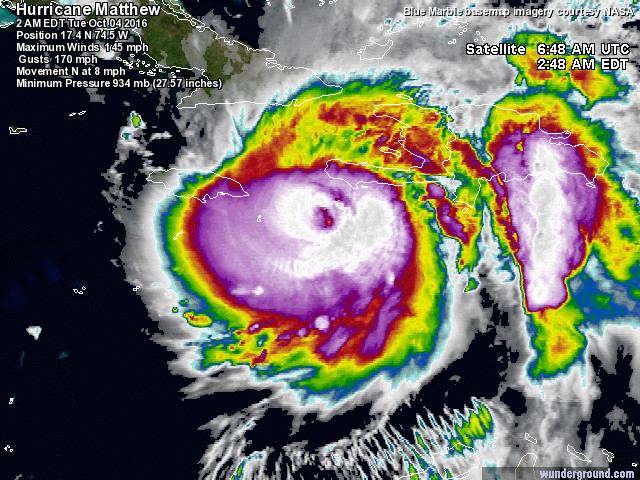
Satellite image of Hurricane Matthew, via Weather Underground
.
I blogged about the vulnerability of Haiti to hurricane rainfall right back in 2008. I wrote:
The landscape has little capacity to intercept and store water, and once flows across the surface begin the landscape rapidly erodes. The hills are clearly suffering from extreme deforestation. In September 2004, Hurricane Jeanne triggered mudslides and debris flows from these hills that killed over 3000 people in the city [of Gonaives]. Bearing in mind the fact that Haiti should be densely vegetated with tropical forest, the disaster that is the landscape in this country is all to clear to see. Unfortunately, posts about landslide disasters in Haiti will be a feature of this blog in the late summer for years to come.
Since then Haiti has suffered a major earthquake, and this is the first very extreme rainfall event since. The scene is set for a disaster, sadly.
Similar posts that might be of interest:
- Hurricane landslides in Haiti
- Deforestation, erosion and Cholera in Haiti
- Images of landslides triggered by the Haiti earthquake
- So just how bad was the debris flow at Barangay Andap during typhoon Bopha / Pablo ?
- Typhoon Bopha – a very real landslide threat for the Philippines
- Landslides in Japan from typhoon Talas
- Landslides from typhoon Megi in Taiwan
3 October 2016
The location of the Rizhao rockslide in Shandong
The location of the Rizhao rockslide in Shandong
Over the last few days a number of people (see acknowledgements below) have sent details of the location of the Rizhao rockslide in Shandong, about which I posted last week. Please accept my apologies for the slow response – I have just completed an epic journey back from Wellington in New Zealand – which is about as far as you can go from Norwich without using a rocket – so I have a number of important landslides upon which to catch up this week (and thanks to those that have tipped me off about other interesting events). Watch this space. And, as an aside, I am deeply worried about the landslide potential of Hurricane Matthew as it makes landfall over Jamaica and Haiti, probably tomorrow. This has the potential to cause real problems – a direct hit on Haiti could be very nasty.
Anyway, the location of the Rizhao landslide is now clear. Strangely enough it turns out that it is not actually in Rizhao, but in Lanshan at 35.104° N, 119.325° E. This is a Google Earth image of the site from 2012 – clearly a lot of work has been undertaken since then:
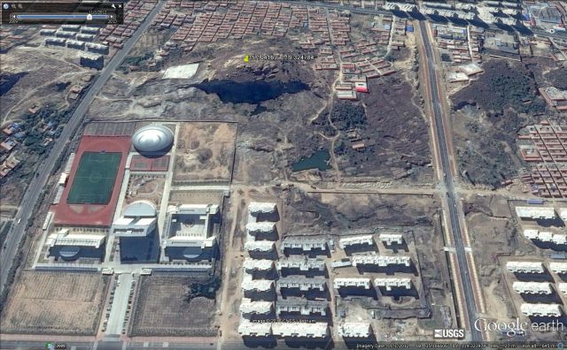
Google Earth image of the location of the Rizhao rockslide, taken in 2012
.
In a comment added to my original post, Marc tracked down some images of the site before the landslide:
The slope prior to the Rizhao rockslide in Shandong
.
Marc comments that:
My guess would be a large wedge style failure. Bedding is clearly visible and would be in a toppling geometry, but the failure plane appears to be on an inclined joint. In such an arrangement removal of material at the toe could provide a release mechanism.
This seems spot on to me. I remain surprised that this is described as a natural landslide when works had obviously been undertaken on the slope. And the image above suggests that this is a slope with a strong set of joints that had the potential to allow release of the landslide.
Similar posts that might be of interest with regard to wedge failures:
- Kalimpong Day 4 part 1: An interesting and deadly roadside landslide
- A major rockslide on US2 near Wenatchee
- The mechanism of the Highway 3 landslide in Taiwan
- Rockfall sequence in Yosemite
Acknowledgements:
Thanks to Marc, Kirk and Jon Johnson, all of whom helped to track down the location of the landslide.
28 September 2016
Rizhao rockslide: a narrow escape in a new public park in Shandong, China
Rizhao rockslide in Shangdong
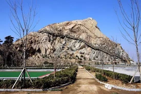
The city of Rizhao in Shangdong, Eastern China has had an exceptionally lucky escape this week when a rockslide occurred in a new public park, shortly before it was due to open. The location is Phoenix Mountain in the centre of the city; the Park was due to open “later this month”. The rockslide itself is somewhat dramatic, as this image from The Nanfang shows:-
The rockslide at Rizhao in Shandong, via The Nanfang
.
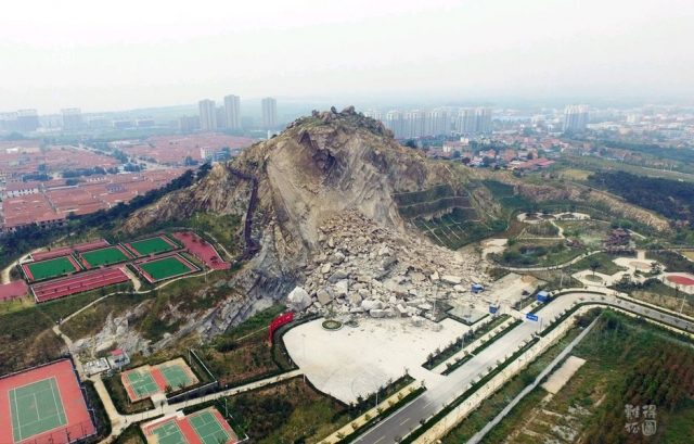
A view of the rockslide from a different angle looks no less dramatic:
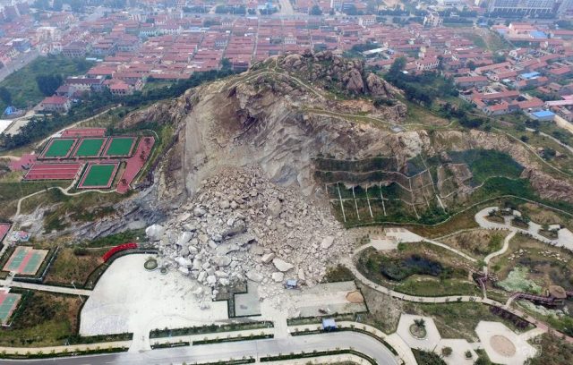
The rockslide at Rizhao in Shandong, via The Nanfang
.
According to the article, this slope had been turned into a rock climbing facility, and the area to the right of the landslide shows evidence of extensive slope engineering. I assume that this extended into the area that has failed, although it is not possible to say what it looked like. The failure itself appears to have been structurally controlled. Note the very large boulder sizes. Needless to say, if this landslide had occurred a month later the impact could have been very dramatic, with losses on the slope, in the park and in the parking area. The article makes some interesting observations about cause:
Zhang Bao, director of Lanshan District emergency services, said a preliminary investigation has determined that the landslide was a natural phenomenon, and not man made. However, Zhang did not answer questions as to why the park facilities are located so close to the mountain, or if any studies or investigations were conducted prior to the construction of the rock climbing facility.
That is a courageous conclusion in an area that has clearly had extensive slope works. Unfortunately as yet I have been unable to precisely locate this massif on Google Earth, so as yet cannot give an indication as to what this site was like before they works were undertaken. My best guess (and it is no more than that) is that it is this site, the image is from last year:
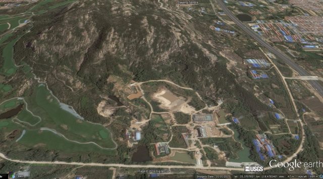
Google Earth image of the possible location of the Rizhao rockslide
22 September 2016
Wye River: landslides in the aftermath of a forest fire in Australia
Wye River: landslides in the aftermath of a forest fire in Australia
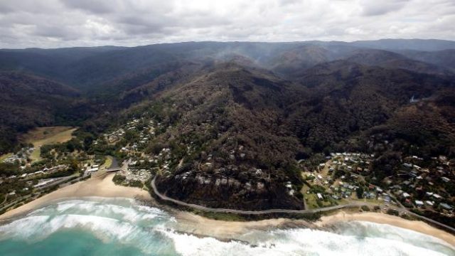
The small town of Wye River, on the coast of Victoria in the southeast corner of Australia, suffered devastating forest fires in the summer of 2015. Wye River itself lost 98 homes – one third of the town – and a further 18 were lost in nearby Separation Creek. Over Christmas last year a desperate battle was fought to save the remainder of the town, successfully, but images of the aftermath remain horrifying:
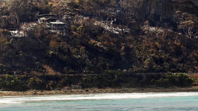
The aftermath of the Wye River fire, via Herald Sun and Aaron Francis
.
A well documented hazard in the aftermath of a large fire is the potential for increased landslides. Last week this area suffered heavy rainfall, triggering multiple landslides along the Great Ocean Road, which passes through the town (and can be seen in the image above). More than 150 landslides and rockfalls have been reported along the road in the last three weeks, and the highway remains severely restricted:
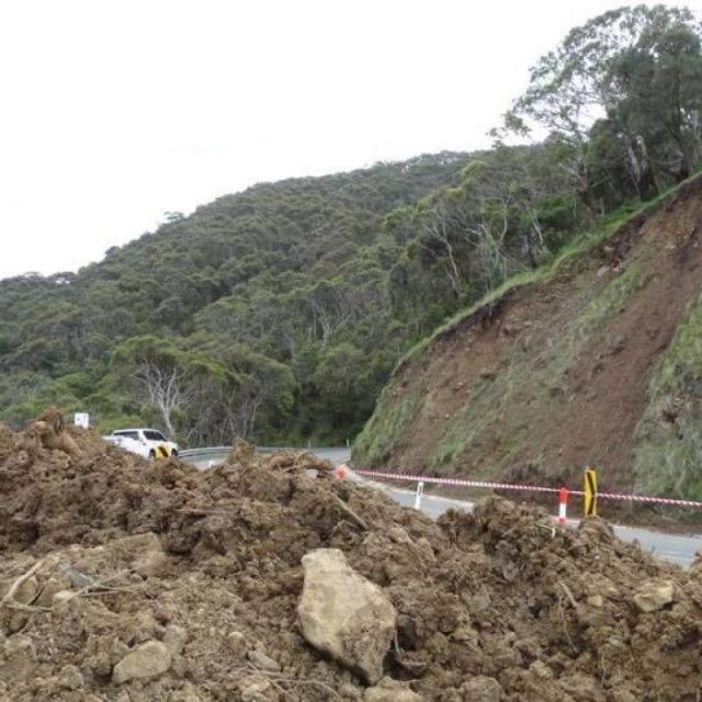
A landslide on the Great Ocean Road near Wye River, via Twitter
.
The most serious issue though is situated between Wye River and Separation Creek, where a landslide of about 1,000 cubic metres has developed, opening a large tension crack:
“The Paddy’s Path was impacted by a 35-metre tension crack and is posing a very significant landslip risk,” the EMV said, after VicRoads engineers inspected the path between Wye River and Separation Creek on Thursday. Wye River General Store’s Shaun McKinlay said the situation was “all too familiar” for residents, who faced the isolation of road closures, and the worry of not knowing what was going to happen next for the second time in less than 10 months. Mr McKinlay said on Friday he understood the crack becoming a landslide was an “event that’s going to happen, they just don’t know when”.
This is a GGoogle Earth image of the location of Paddy’s Path in Wye River:
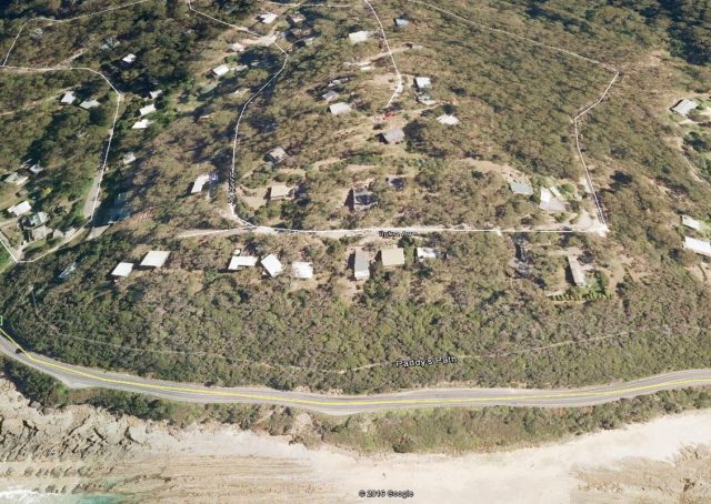
Google Earth image of the location of the Wye River landslide. This image predates the fire.
.
This image shows the area burned in the fire of December 2015:
The aftermath of the December 2015 fire in Wye River, via Herald Sun and Hamish Blair
.
It is clear that the area affected by this landslide is exactly that burned in the fire last year. The link between the two is of course not a coincidence. That forest fires are becoming increasing problematic as a result of climate change is also well established in Australia. The implications for the future in terms of landslides are clear.
Similar posts likely to be of interest:
- Australian wildfires and risks of increased erosion rates
- Emergency assessment of wildfire debris flow potential
- AGU Day 4: Debris flows and the Station Fire [improved in light of comments from Susan Cannon]
- Mudslides occur in the areas affected by the 2009 Station Fire in Los Angeles
 Dave Petley is the Vice-Chancellor of the University of Hull in the United Kingdom. His blog provides commentary and analysis of landslide events occurring worldwide, including the landslides themselves, latest research, and conferences and meetings.
Recent Comments