3 October 2016
The location of the Rizhao rockslide in Shandong
Posted by Dave Petley
The location of the Rizhao rockslide in Shandong
Over the last few days a number of people (see acknowledgements below) have sent details of the location of the Rizhao rockslide in Shandong, about which I posted last week. Please accept my apologies for the slow response – I have just completed an epic journey back from Wellington in New Zealand – which is about as far as you can go from Norwich without using a rocket – so I have a number of important landslides upon which to catch up this week (and thanks to those that have tipped me off about other interesting events). Watch this space. And, as an aside, I am deeply worried about the landslide potential of Hurricane Matthew as it makes landfall over Jamaica and Haiti, probably tomorrow. This has the potential to cause real problems – a direct hit on Haiti could be very nasty.
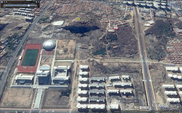
Anyway, the location of the Rizhao landslide is now clear. Strangely enough it turns out that it is not actually in Rizhao, but in Lanshan at 35.104° N, 119.325° E. This is a Google Earth image of the site from 2012 – clearly a lot of work has been undertaken since then:

Google Earth image of the location of the Rizhao rockslide, taken in 2012
.
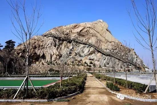
In a comment added to my original post, Marc tracked down some images of the site before the landslide:

The slope prior to the Rizhao rockslide in Shandong
.
Marc comments that:
My guess would be a large wedge style failure. Bedding is clearly visible and would be in a toppling geometry, but the failure plane appears to be on an inclined joint. In such an arrangement removal of material at the toe could provide a release mechanism.
This seems spot on to me. I remain surprised that this is described as a natural landslide when works had obviously been undertaken on the slope. And the image above suggests that this is a slope with a strong set of joints that had the potential to allow release of the landslide.
Similar posts that might be of interest with regard to wedge failures:
- Kalimpong Day 4 part 1: An interesting and deadly roadside landslide
- A major rockslide on US2 near Wenatchee
- The mechanism of the Highway 3 landslide in Taiwan
- Rockfall sequence in Yosemite
Acknowledgements:
Thanks to Marc, Kirk and Jon Johnson, all of whom helped to track down the location of the landslide.


 Dave Petley is the Vice-Chancellor of the University of Hull in the United Kingdom. His blog provides commentary and analysis of landslide events occurring worldwide, including the landslides themselves, latest research, and conferences and meetings.
I agree that that is unlikely to be natural. The 2009 Google Earth picture shows that the site was a quarry, which they simply transformed into a park, including installing the steps to the top of the quarry face and making part of it into a climbing wall. Clearly a nice idea, but evidently rock stabilization was either omitted or not done correctly.