
20 September 2016
A science story that just won’t die: the Canary Island Megatsunami scare rears its head once more
The Canary Islands Megatsunami scare story
With frightening and depressing regularity the Canary Islands Megatsunami scare story rears its ugly head, to breathless headlines in the popular media. In case you need reminding, this is a scenario that involves a giant landslide from the flanks of the Cumbre Vieja volcano in the Canary Islands, which then generates a vast tsunami that sweeps across the Atlantic Ocean, causing untold devastation across a large area. It has been repeatedly debunked. This story reappeared this weekend in the Daily Star, which might not be considered to be a competitor to the Wall Street Journal, if you know what I mean. Inevitably the story is sensational:
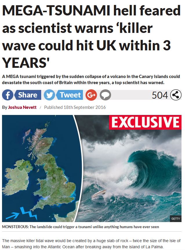
The Daily Star Canary Islands Megastunami headline
.
Sigh! And of course it is accompanied with a map of the extent of the tsunami, with annotation to show just how big the impacts would be:
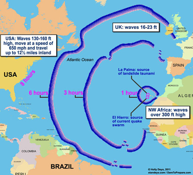
The impact of the supposed Canary Islands Megatsunami via the Daily Star
It is hard to know where to start with this as the story has been debunked so many times. So let me try to outline some of the key issues with the Canary Islands Megatsunami scare story:
- The generation of a tsunami on this scale requires a very specific landslide scenario. This is that the flank collapse occurs in a single enormous (we are talking 350 cubic kilometre) event and is extremely rapid. Hypothetically this is possible, but it is not likely. This is like saying that I’m worried that my house will be destroyed by a meteorite. It could of course happen, but it is so vanishingly unlikely that it is not worth considering. It is simply wrong of the newspaper to present an outlier scenario as one that seems likely.
- Studies of submarine volcanic flank collapse deposits suggest that they do not happen as a single coherent block, but instead as a series of slides. The resultant tsunami would be much less significant;
- The concept of “within three years” is a nonsense. Of course it principle could happen within three years – it could indeed happen tomorrow. Why three years? Not five? or 50? Or 3000?
- Most importantly, we know that this volcano, and many others, have undergone massive flank collapse in the past on multiple occasions. We even know that some have generated large local tsunamis. But large tsunamis leave a very distinct sediment footprint on the coast – tsunami deposits are well characterised and mapped, and no self-respecting geologist would miss a large one. And the megatsunami deposit from an event like that shown in the map above would be locally huge and would be present over a vast area. There is no way that such a deposit would be missed. But no such pervasive, recent, continent-scale tsunami deposit has ever been found. This indicates of course that none of the previous flank collapse events has generated a megatsunami on this scale, or even close to it. And I mean none of them – not from the Canary Islands, not from Hawaii, not from anywhere else. So, in some way, the potential flank collapse at Cumbre Vieja has to be fundamentally different from all that have gone before.
- And finally, even if Cumbre Vieja did collapse as hypothesized, the tsunami model described above would have to be right. Personally I find it hard to believe that a tsunami wave that is in effect generated by a point source and that has crossed the mid ocean ridge (and thus encountered comparatively shallow water) could generate a wave over 50 m high along a length of coastline thousands of kilometres long.
So does this mean that Cumbre Vieja can generate a large tsunami? Yes, of course. But is it even remotely likely beyond the local area? Absolutely not, in my view.
And of course aspects of this are silly from a risk perspective:
“Although Florida and the Caribbean would suffer the greatest destruction, with waves up to 164 ft smashing their coastlines, a weaker, but still massively destructive wave, is likely to batter Britain. It is thought thousands of people living in Britain’s southernmost coastal cities and towns, including Cornwall, Devon and Portsmouth, could be wiped out within hours, assuming no effective evacuation.”
And:
“I would argue that they, their political overseers, and we the general public, should worry about the potential impacts of collapse generated tsunamis on a range of coastal nuclear facilities, ranging from power stations through nuclear reprocessing plants to dockyards full of decommissioned nuclear submarines.”
Frankly if a wave 50 metres high has just struck the entirety of the Eastern Seaboard of the USA and Canada, the Caribbean and the eastern coasts of Latin America; and a wave 100 m high has struck the western coast of Africa; and a wave has just wiped out western coasts of France, Portugal, Ireland, and the UK, all within six hours, then a wave 6 m high hitting Hinckley Point is going to be a pretty small part of the overall equation.
It really is time that this event was presented for what it is, which is an absolutely extreme scenario based on a very highly unlikely combination of events that is without precedent. There are lots of credible hazard scenarios that deserve our attention; this one does not.
19 September 2016
A great new landslide video: Piz Cengalo
Piz Cengalo landslide video
On 11th September a significant rockfall occurred on Piz Cengalo, a peak located in the Swiss alps on the border with Italy in the canton of Grabunden. This is a peak that has had significant landsliding in recent years, most notably in 2011 when a large landslide involved about 1.5 million cubic metres of rock.
The landslide on 11th September was caught on video from a number of different angles. Probably the best was collected by Roman Christoffel:
.
This is an unusually clear video of such an event that captures in particular the transition from free fall to rock avalanche beautifully:-
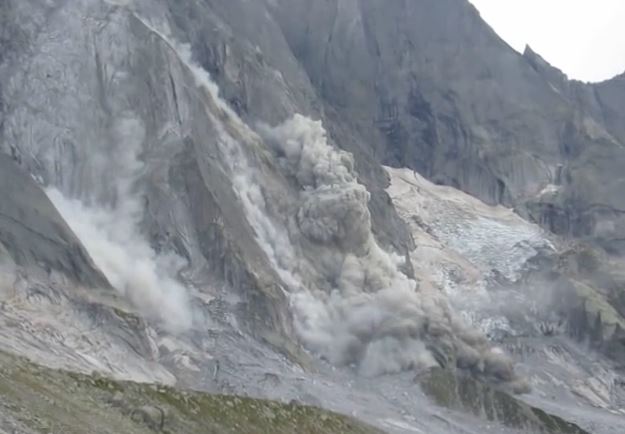
Rockfall and rock avalanche on Piz Cengalo. Video by Roman Christoffel via Youtube
.
The landslide was also captured from two other angles. This angle in particular is fabulous in the way that it shows the evolution of the rock avalanche and associated dust cloud:
.
Whilst this one shows the latter stages of the runout of the Piz Cengalo rock avalanche:
.
And finally a more distant view of the same event:
.
I cannot really think of another landslide that has been caught so well from so many different angles simultaneously.
Il Grigione Italiano has a nice article (in Italian though Google Translate does a good job) about the landslides. This suggests that the 11th September landslide on Piz Cengalo had a volume of about 100,000 to 150,000 cubic metres. As such this is small compared with the events of five years ago, and the runout meant that the damage was limited. Nonetheless, the authorities are clearly (and rightly) mindful of the continued landslide activity at this site and are maintaining the closure of some local hiking trails.
Posts on a similar topic:
- The Val Strem rockslide – a dramatic long run out landslide in Switzerland
- Wolhusen: an interesting river-blocking rockfall in Switzerland
- The remarkable Preonzo landslide in Switzerland last week
- The Randa rockslide – a spectacular new video
Acknowledgement:
Thanks to my former student Dr James Glover for the heads up about this event.
8 September 2016
PhD opportunity: A platform for regional scale earthquake induced landslide hazard assessment
A PhD opportunity in New Zealand in earthquake induced landslide hazard assessment
.
A Platform for Regional-Scale Earthquake induced landslide hazard assessment
Chris Massey at GNS Science in New Zealand is advertising the following very interesting PhD opportunity in earthquake induced landslide hazard assessment:
Research Goal
Develop a planning and operational tool to forecast the number, volume and runout distance of landslides generated by different types and magnitudes of earthquakes in the varying materials and slopes around New Zealand.
Forecasting the location and size of earthquake-induced landslides as well as the distance they might travel down a slope are each complex process. Currently most approaches use statistical models, based on data from landslides triggered by past earthquakes located around the world. Many of these approaches focus on landslide susceptibility only, by identifying where landslides are more likely to occur in the terrain, rather than hazard, which also incorporates the downslope area affected by the debris should the landslide occur. In addition, few such statistical susceptibility relationships are calibrated to New Zealand geology and terrains. Many of the larger landslides triggered by recent earthquakes have a strong structural geological control and are not well predicted by the statistical models. A sub-component of this research will be to investigate relationships between geological structure, landslide-failure mechanisms and volume.
In this project, the PhD candidate would aim to address these issues by developing a computational GIS-platform to enable high-resolution regional-scale landslide hazard identification for different regions of New Zealand. This will comprise two components:
- A national probabilistic coseismic landslide hazard map (including runout), driven by the probabilistic seismic hazard model (PHSM) and with hazard related to susceptibility parameters calibrated with NZ and overseas landslide distributions and other information. This can be updated as the PHSM is updated, and will inform management of earthquake emergencies and other planning
- A rapid-assessment routine driven by the magnitude, location and depth, and shaking intensity of a specific earthquake. This will be based on 1 (above), and calibrated against known NZ earthquakes; it will inform initial response operations for a specific event.
The candidate will have access to new earthquake-induced landslide datasets captured for some recent earthquakes in New Zealand. The research is timely and will be used to develop the national New Zealand landslide forecast system being developed by GNS Science and others over the next five years.
The person
We are looking for a PhD candidate so that we can apply for a fully-funded PhD scholarship, including University fees and living allowance. The candidate, if successful, would be enrolled at the University of Canterbury, New Zealand, and work in close collaboration with GNS Science and QuakeCoRE. The candidate would be expected to spend time in both Wellington and Christchurch, two of New Zealand’s more interesting cities.
If interested, please send [email protected] your CV before the 23rd September 2016.
Other blog posts of relevance regarding earthquake induced landslide hazard assessment in New Zealand:
- Sumner rockfalls – videos from the M=5.7 earthquake near Christchurch yesterday
- Rockfall and landslide damage in the Port Hills from the Christchurch earthquake sequence
- Port Hills, Christchurch: demolishing the rockfall threatened houses
- Rockfall risk assessment reports for the Port Hills, Christchurch, New Zealand
- Away from AGU – images of rockfalls as they occurred during the June 2011 Christchurch earthquake
- Images of landslides from the Christchurch earthquakes part 1: boulder damage to a house
- Images of landslides from the Christchurch earthquakes part 2: evil dancing boulders
- Images of landslides from the Christchurch earthquakes part 3: topographic amplification at the cliff tops
- Landslides from the Christchurch earthquakes part 4: large-scale cliff collapses
- Landslides from the Christchurch earthquakes part 5: landslides that involve sliding
7 September 2016
Why maintaining forest roads is important – a large landslide triggered by a small culvert failure
The reasons why maintaining forest roads is important – a large landslide triggered by a small culvert failure
Carolyn Cook of the Six Rivers National Forest in California has posted online an amazing powerpoint presentation showing the chain of consequences that can occur when there is inadequate maintenance of drainage (and in particular if a culvert) on forest roads. She has kindly agreed that I can post about it here – the original file can be obtained from here. I have posted below some of the slides from the presentation.
The events occurred at Bluff Creek in the Six Rivers National Forest in January 2006. It started with inadequate maintenance of a large (48 inch = c.1200 mm) culvert:
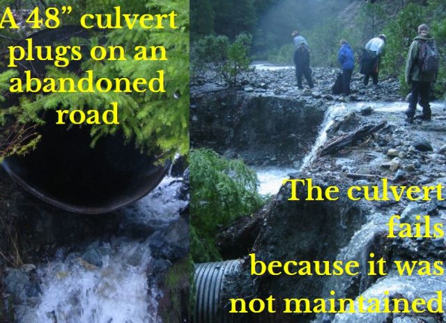
Culvert failure on Bluff Creek, via Carolyn Cook of Six Rivers National Forest
.
The stream then diverted down the road, incising a channel en route:
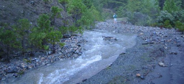
The diverted channel via Carolyn Cook of Six Rivers National Forest
.
About 300 m down the road the flow diverted off the road and into the forest:
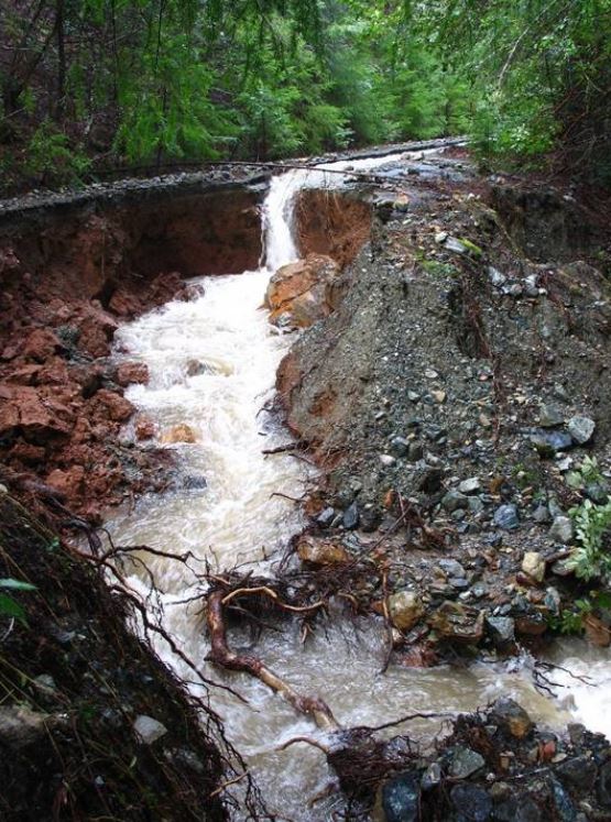
The flow diverting into the forest via Carolyn Cook of Six Rivers National Forest
.
The new channel incised into the soil to create a gully, and then flowed over the break of slope onto the lower slopes:
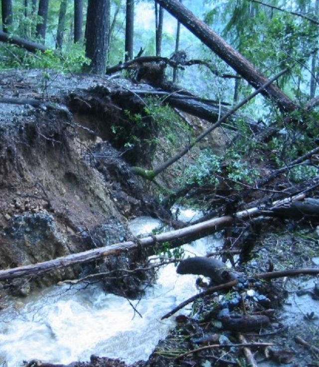
The new, deeply incised gully via Carolyn Cook of Six Rivers National Forest
.
On the lower slope it triggered a landslide that covered 3 acres (about 12,000 square metres):
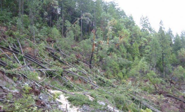
The newly triggered landslide via Carolyn Cook of Six Rivers National Forest
.
This landslide permanently destroyed a newly-constructed road that had cost about US$750,000:
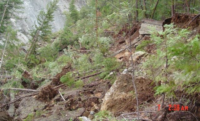
The destroyed road via Carolyn Cook of Six Rivers National Forest
.
The landslide and gully then delivered a large volume of sediment to the river, damaging the ecosystem:
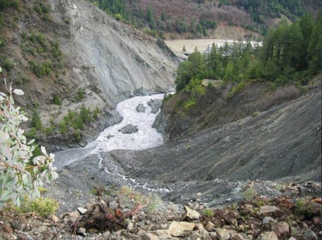
Sediment being delivered to the river, via Carolyn Cook of Six Rivers National Forest
.
This is a dramatic example of the ways in which a lack of maintenance on low cost roads can have dramatic consequences on landslides. This pattern is repeated again and again in, for example, Nepal where forest roads are constructed without managing the drainage. I continue to believe that this is a major factor in the high level of loss of life in the Himalayas and other mountain chains. But even in a developed country like the USA, poor basic road maintenance leads to massive environmental damage over long distances. and loss of amenities such as other forest roads:
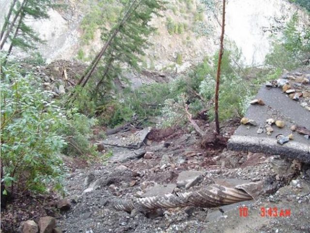
The damaged forest road, via Carolyn Cook of Six Rivers National Forest
.
Other posts on a similar theme:
- An interesting video of the failure of a road culvert
- The Farnley Haugh landslide in Northumberland, N England, probably caused by poor slope water management
- A video of a road collapse in Thailand, probably induced by the failure of a culvert
And of course this classic Youtube video of the failure of a culvert:
Acknowledgements
Thanks to Carolyn Cook of Six Rivers National Forest for putting together this brilliant example, and for allowing me to use it, and to Ellen Hardy of U.S. Forest Service Rocky Mountain Regional Office in Golden, Colorado for bringing it to my attention and putting me in contact with Carolyn.
6 September 2016
Landslides in Art part 27: Louise Collis
Landslides in Art part 27: Louise Collis
This is part 27 of my occasional Landslides in Art series – see the links at the bottom of the page for some earlier editions, including Part 26, Robyn Collier. This time I am featuring a painting by the artist Louise Collis entitled Blaina Landslide.
Louise is a landscape artist based in South Wales. She describes herself as follows:
Based in the South Wales with the beautiful mountains, industrial villages and a fantastic coastline on my door step, I am inspired by the changing colours, light and history of the landscape. I take my painting kit everywhere and can often be found sat on a hillside or cliff painting on a sunny day or inside my car/studio on a rainy day.
Louise has a studio in Abergavenny in South Wales. Starting in July 2014, Louise focused on a project to create one Plein Air landscape painting per day:
In May 2014 I had the idea to create one landscape painting, outdoors, everyday for a year. It was a very exciting idea that would see me painting the changing seasons and my travels around the country. To help get the project started and cement my commitment to it I posted it on Kickstarter – a crowd funding website, and invited people to support the project by buying the paintings in advance. By June 2014 I was thrilled to get the support of over 50 backers and was able to order all the painting boards required and schedule some painting trips. I started painting in July 2014 and have been sending my backers monthly updates. It has been an incredibly enjoyable and informative process. The changes in my painting style has been documented as well as the seasons, and I’ve now produced a large body of work that I’m very proud of and are proving to be great inspiration for other work.
The Paintings are all 8” x 6” Oil on Board
The painting I am featuring is number 232, painted in the Spring of 2015:
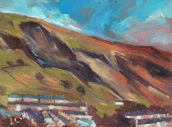
Painting number 232 in the 365 Project by Louise Collis: “Blaina Landslide”
.
Louise describes the painting as follows:
Painted on 4 March looking at the old landslip above house at Blaina in the Bleanau Gwent Valley.
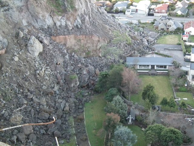
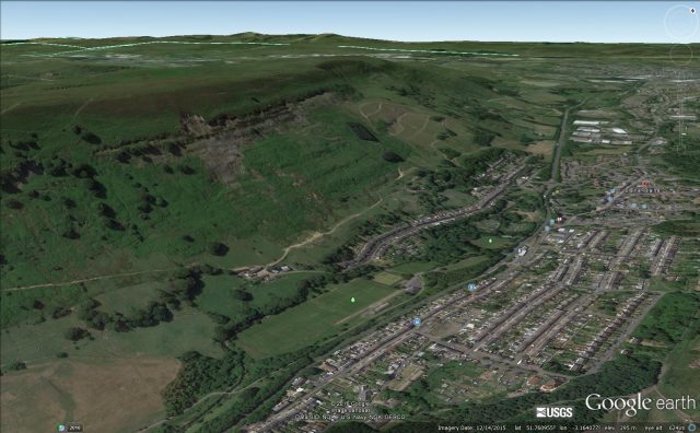
Blaina is a small town situated in the Valleys of South Wales with a population of about 5,000 people. This an area that was once dominated by coal mining, but the Beynon’s Colliery was closed in April 1975 after an underground fire. The valleys have a long history of landslides, exacerbated by the mining. The Google Earth image below shows the slopes above Blaina, with a number of landslides:
Google Earth imagery of landslides in the Balina area
.
Note the obvious rockslide in the foreground and the much larger, probably older landslide that has taken a bite our of the ridge for example. On the opposite valley wall there is another series of large landslides, and it is these that Louise Collis has painted:
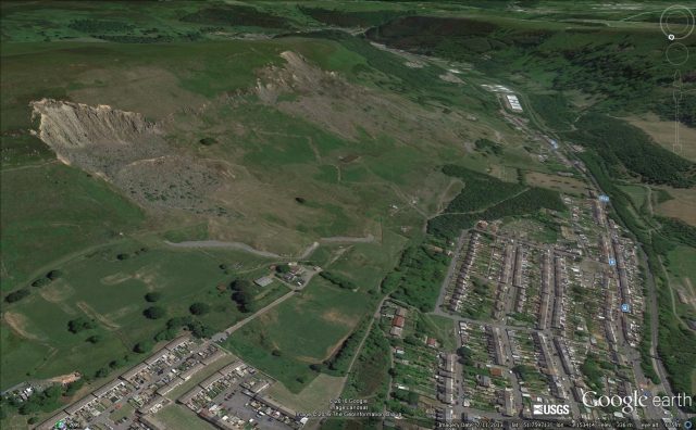
Google Earth image of landslides in the Blaina area of South Wales
.
These landslides required considerable work in the 1980s.
Blaina has a long history of landslides – a report by R.H. Pullen of Gwent County Council identified four significant landslides in the area for example. The painting by Louise Collis captures the drama of the landslides, with the presence of the houses providing a distinctly human context. The painting is still on sale.
Previous editions of the Landslides in art series:
Landslides in Art Part 26: Robyn Collier
Landslides in Art Part 25: Richard Humphrey
Landslides in Art Part 24 – Mary Buckland
Landslides in Art Part 23: Marzia Colonna
Landslides in Art Part 22: Aberfan (7 pianos, percussion, voice and tools of rescue)
Landslides in Art Part 21: Harlequin
Landslides in Art Part 20: A cannonade on the Matterhorn 1862
4 September 2016
Taplejung: another burst of fatal landslides in Nepal
Taplejung: another burst of fatal landslides in Nepal
The last month or so in Nepal has been marked by a lower level of landslide activity than was the case at the start of the monsoon season. However, not unusually, heavy rainfall at this later stage has triggered a new burst of landslides in Nepal, with the district of Talejung in the east of the country being particularly badly affected it seems. The Kathmandu Post reports seven deaths in the last 48 hours, including three deaths in a single landslide in Taplejung Municipality, a further death in another part of the same area, two deaths in a landslide in Kulung village in Bhojpur and one in Devisthan in Myagdi district. Review Nepal reports a further four deaths in Keware in Syangja district early this morning. At the end of last week, Republica reported that a child was killed in a landslide at Gajuri in Dhading district, and on Wednesday night seven people were killed in a landslide at Chyotchyot, which lies in Lamabagar Village Development Committee in Dolakha district.
Thus, in the last five days I believe there have been 19 landslide deaths in Nepal.
The Kathmandu Post has an article with images of some of the landslides in the Taplejung area. This includes this photograph, taken by Ananda Gautam, shows a series of very mobile and surprisingly large debris slides on steep slopes:
Landslides in Taplejung, via the Kathmandu Post and Ananda Gautam
.
The article suggests that this is the area calledDokhu in Taplejung, which is identified in Google Earth as being this region:
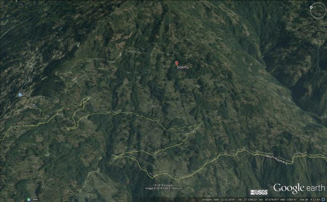
Google Earth image of the Dohku area of Taplejung district
.
It would of course be very interesting to know what is at the head of these landslides higher up the slope. Often such failures start with a comparatively small landslide that then entrains large amounts of soils and regolith. Experience suggests that these small landslides are often associated with road building, poor drainage and / or the emplacement of fill.
Previous article of relevance to this post:-
- Landslides in Nepal from the 2016 monsoon
- Monsoon 2016: Nepal reels under the effects of multiple landslides
- Nepal landslides: over 30 killed yesterday in Kaski and Myagdi
2 September 2016
Uttarkhand and Siliguri: two new landslide videos from India
Uttarkhand and Siliguri: two new landslide videos from India
Two interesting landslide videos have been posted on Youtube, one from Uttarakhand and one from Siliguri.
The most interesting is this video from the Gangotri Highway in Uttarakhand between Rishikesh and Badrinath. the road was reportedly closed for 15 hours:
.
The dynamics of the failure are quite complex as the major boulder in effect goes through a toppling motion, with a great deal of rotation:
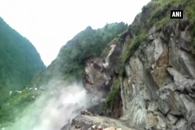
Landslide in Uttarakhand via Youtube
.
And secondly, this event reportedly occurred on the Gangtok National Highway in Siliguri. The video was posted on 26th August:
.
If you look carefully you will see that at the time that the bulldozer was struck by the landslide the driver was still in the machine. He emerges from the cab (or from the downslope side of the bulldozer at about the 40 second mark, and then feels the wisely scene). That was a very lucky escape.
1 September 2016
An update on landslides from the M=6.2 Central Italy earthquake
An update on landslides from the 2016 Central Italy earthquake
Dr Salvatore Martino has very kindly provided a further update on yesterday’s post on landslides triggered by the M=6.2 Central Italy earthquake on 24th August:-
Up to now about 150 ground effects have been inventoried, mainly consisting of rock falls and rock slides. These events occurred from both road cuts and natural scarps. The widespread forest cover considerably reduced failure occurrence in the hill zones at elevations below 1000 m a.s.l. Several interventions are in progress to opening blocked roads and restore safe conditions in the vicinity of the the damaged villages.
Image courtesy of Salvatore Martino
.
Image courtesy of Salvatore Martino
.

Image courtesy of Salvatore Martino
.
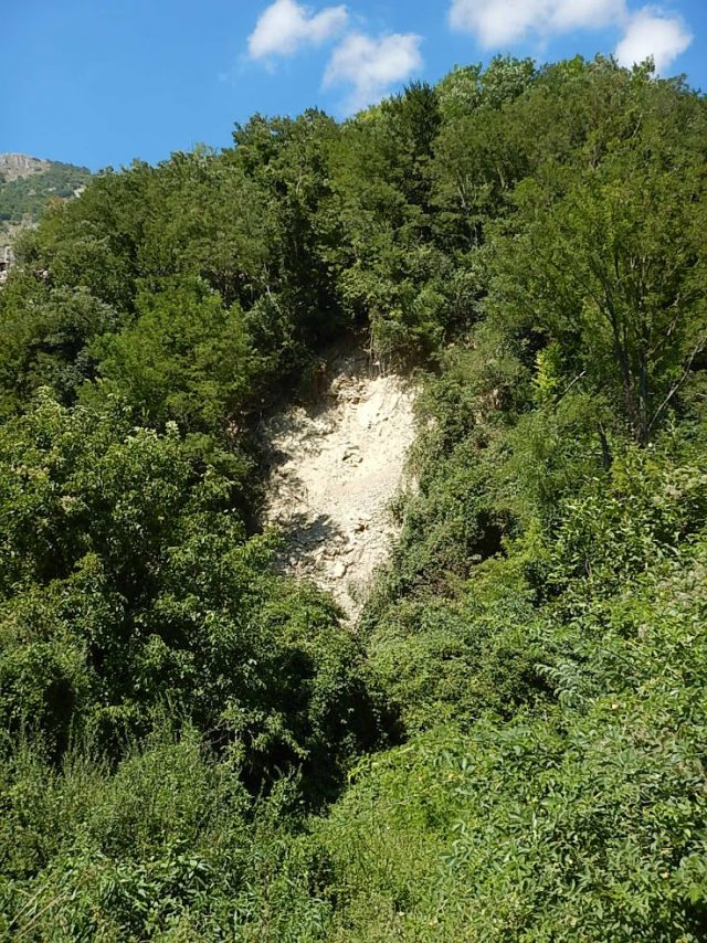
Image courtesy of Salvatore Martino
.
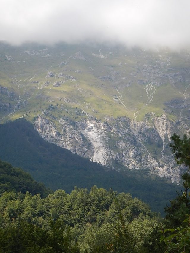
Image courtesy of Salvatore Martino
.

Image courtesy of Salvatore Martino
.
The following picture show a pre- and post- earthquake rock wall at the Corno Piccolo (Gran Sasso Massif):-
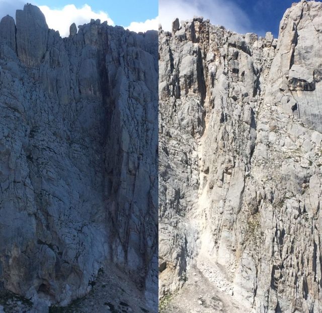
Image courtesy of Salvatore Martino
.
The distribution of these effects is particularly interesting if compared with the one of the previous 1997 Umbria-Marche and 2009 L’Aquila earthquakes as it results from the CEDIT catalogue. The area covered by the new earthquake effects is strictly between the other ones.
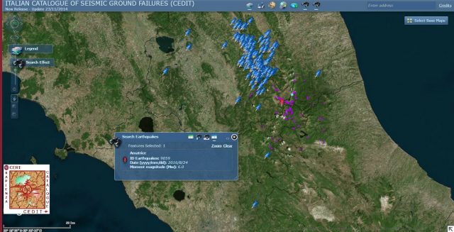
Image courtesy of Salvatore Martino
.
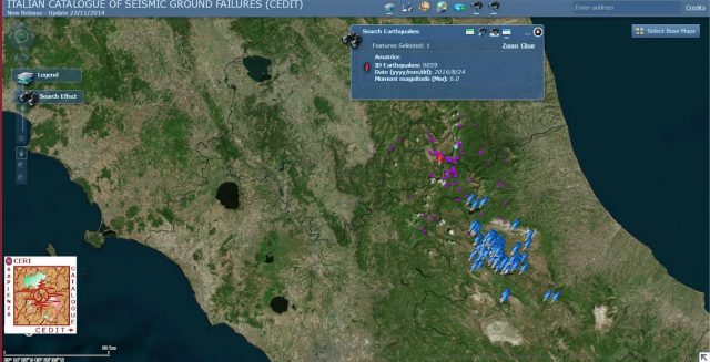
Image courtesy of Salvatore Martino
.
The municipalities which were mainly affected by the earthquake-induced landslides are Accumoli, Amatrice, Arquata del Tronto and Umbria at the borderline of three Italian regions: Lazio, Marche and Umbria.
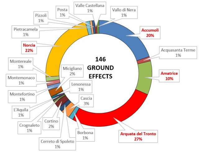
Image courtesy of Salvatore Martino
.
In the CEDIT WebGIS available on-line (http://www.ceri.uniroma1.it/index_cedit.html) each event is inventoried by a technical schedule and an associated picture. The geolocalization of the surveyed events (cartographic reference system in geographic coordinates WGS84), classified according to the level of interaction with infrastructures, is also available in both .kmz and and .shp formats. The inventory is currently updated to 29th August 2016 but further updates will follow in the next days.
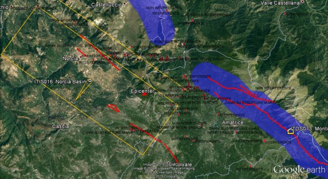
Image courtesy of Salvatore Martino
.
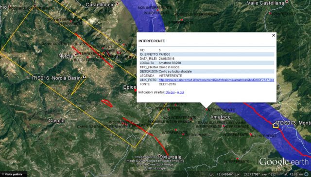
Image courtesy of Salvatore Martino
.
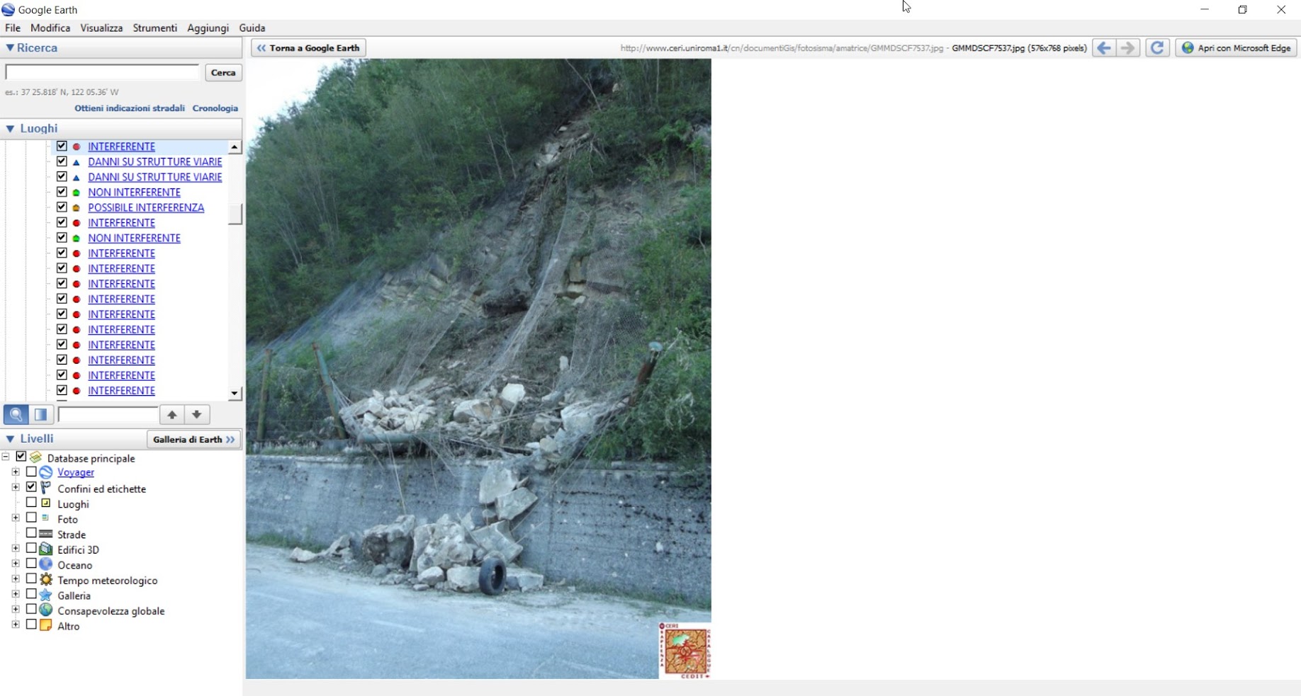
Image courtesy of Salvatore Martino
31 August 2016
Landslides from the 2016 Central Italy earthquake
Landslides from the 2016 Central Italy earthquake
The M=6.2 2016 Central Italy Earthquake on 24th August has been devastating for a number of traditional towns in the Central Apennines. Whilst not particularly powerful, the very shallow depth of this earthquake lead to very intense shaking over a comparatively small area. In this respect it is not dissimilar to the Christchurch earthquakes, which also caused catastrophic damage in the comparatively limited spatial areas affected by high intensity shaking.
Italy is the most landslide prone country in Europe (by far), and the earthquake struck in an upland area. Thus, an immediate question asked by the landslide community was the degree to which this earthquake triggered landslides. Very kindly, Salvatore Martino, Associate Professor in Engineering Geology at the University of Roma “Sapienza”, has sent some images and information for this blog. He is coordinating a research team from the Research Centre for the Geological Risk (CERI) that is surveying the seismically-induced landslides triggered by the 2016 Central Italy earthquake. The aim is that the information will be uploaded into the CEDIT database of earthquake-induced ground failures in Italy (see Martino et al. 2014 – reference below – this is an open access publication).
Dr Martino has provided this extremely helpful commentary:
On 24th August 2016 a strong earthquake (M 6.0 – 42.714°N 13.172°E) struck Central Apennines (Italy) at 3.36 local hour starting a seismic sequence which is still acting. The seismic sequence originated hundreds of aftershocks (with a magnitude up to 4.3), distributed along a 25 km wide area NW-SE oriented. The seismic sequence caused the complete destruction of the historical towns of Amatrice, Arquata del Tronto, Accumoli and Pescara del Tronto but also severe damages to other local towns and villages. Since the first hours after the mainshock a work-team of the Research Centre for the Geological Risks – CERI of the University of Rome “Sapienza” is operating in field to survey the ground effects induced by the earthquake. Up to now several tens of disrupted landslides (sensu Keefer, 1984) have been surveyed. These events mainly include rockfalls and rockslides which are distributed in a wide area up about 40 km far from the mainshock epicenter included within the main localities of Ascoli Piceno, Teramo, Norcia and Rieti. Some of these events involved roads but no severe damages were generally produced. In the next few days, the surveyed data will be used to update the database (Italian acronym CEDIT) of earthquake-induced ground failures in Italy (Martino et al., 2014), managed by the CERI and they will be available at the web site
Dr Martino has also provided these images:
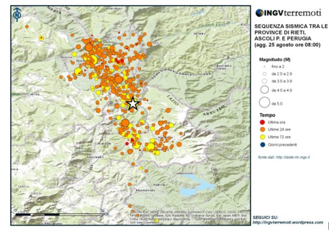
The seismic sequence for the 2016 Central Italy earthquake – via INGVterremoti
.
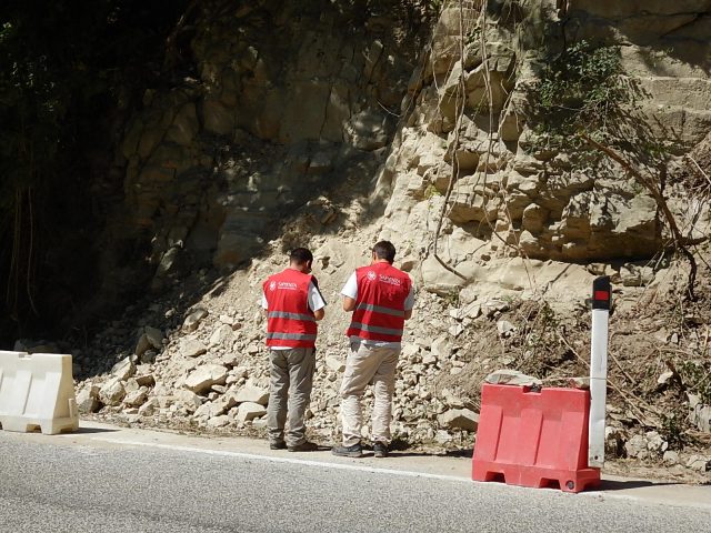
Image courtesy of Salvatore Martino
.
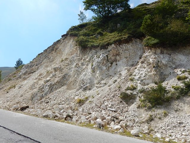
Image courtesy of Salvatore Martino
.
Image courtesy of Salvatore Martino
.
Image courtesy of Salvatore Martino
.
Image courtesy of Salvatore Martino
.
Image courtesy of Salvatore Martino
.
Reference
Martino, S., Prestininzi, A., and Romeo, R. W. (2014) Earthquake-induced ground failures in Italy from a reviewed database. Natural Hazards and Earth System Science, 14, 799-814, doi:10.5194/nhess-14-799-2014.
30 August 2016
The official report into the Samarco Tailings Dam failure in Brazil
The official report into the Samarco Tailings Dam failure in Brazil
Yesterday the official report into the Samarco Tailings Dam failure and associated flowslide last year in Brazil was released. Impressively, a website has been set up to provide access to the report – there is a simple registration process after which the full report is freely available. This is a full and comprehensive investigation that needs detailed explanation, undertaken by a highly credible panel. I will give only the highlights here.
The report finds that the failure initiated in the left abutment of the dam as a result of groundwater pressures in an area of the dam that “was underlain by slimes”. In other words, this portion of the dam was constructed on mining waste. The mechanism of failure is well-known – so called lateral extrusion – which occurs when soft sands overlie soft mining waste. The latter then spreads laterally, deforming the overlying sands.
The report provides a nice illustration of the failure sequence:
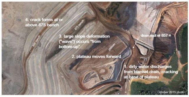
\Illustration of the failure sequence of the Samarco tailings dam, from the official report
.
The question of course is then how the site of the Samarco Tailings Dam failure ended up in this vulnerable state. The report is quite clear on this, and the analysis is not going to be comfortable reading for the operators:
Why Did a Flowslide Occur?
The original design concept for the Fundão Dam employed an unsaturated sand zone to support the weak slimes zone. Unsaturated sand is not amenable to liquefaction and hence the original design was robust in this regard. However, difficulties were encountered in executing the design and a modified design was put forward and adopted. As part of this modification, a change in the design concept was also adopted and saturated conditions were permitted to develop in the sand.
The report documents a series of significant events leading up to the failure. In 2009 a major seepage event occurred in the dam:
The first incident occurred in 2009 shortly after the Starter Dam was completed. Due to construction defects in the base drain, the dam was so badly damaged that the original concept could no longer be implemented. Instead, a revised design substituted a new drainage blanket at a higher elevation.
Then in 2011 and 2012 problems arose with management of the mining waste and water:
The second incident associated with slimes and water management occurred over an extended period of time in 2011 and 2012 while the new design was being constructed. During operation, the 200 m beach width criterion was often not met, with water encroaching to as little as 60 m from the crest. This allowed slimes to settle out in areas where they were not intended to exist.
In 2012 problems arose with structural problems in a concrete conduit under the dam, which required that dam alignment was set back, and the constructed over mine tailings. This can be seen in the diagram above – the setback created the plateau that is highlighted in item 2. Problems developed through 2013 and 2014 as seepage was repeatedly observed, and in 2014 extensive cracking was observed in the left abutment setback.
All of this left the dam in what is described as a “precarious state of stability”. Final failure might have been triggered by three small seismic shocks about 90 minutes before the collapse.
I will blog about the detailed mechanism in the next few days.
 Dave Petley is the Vice-Chancellor of the University of Hull in the United Kingdom. His blog provides commentary and analysis of landslide events occurring worldwide, including the landslides themselves, latest research, and conferences and meetings.
Recent Comments