
15 March 2023
Lago Riesco: a large debris flow in southern Chile
Lago Riesco: a large debris flow in southern Chile
Over the weekend, on images appeared on Twitter of the aftermath of a large debris flow close to Lago Riesco in the Aysen area of southern Chile. The scale of the event, which occurred on 11 March 2023, was impressive:-
https://twitter.com/RedGeoChile/status/1634587316013375488
.
https://twitter.com/RedGeoChile/status/1634585311190589440
.
This was triggered by a period of very heavy rainfall. The Mop Aysen Facebook page has some details about the event, including this image:-
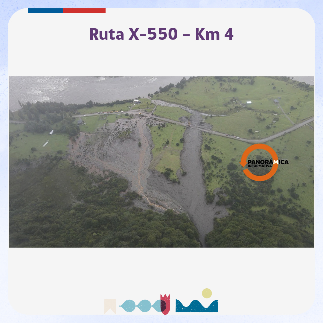
The aftermath of the large debris flow close to Lago Riesco in Chile on 11 March 2023. Image from the Mop Aysen Facebook page. The image was supplied by Panoramica Informativa.
.
The location of this event appears to be [-45.419, -72.632]. This is a Google Earth image of the site:-
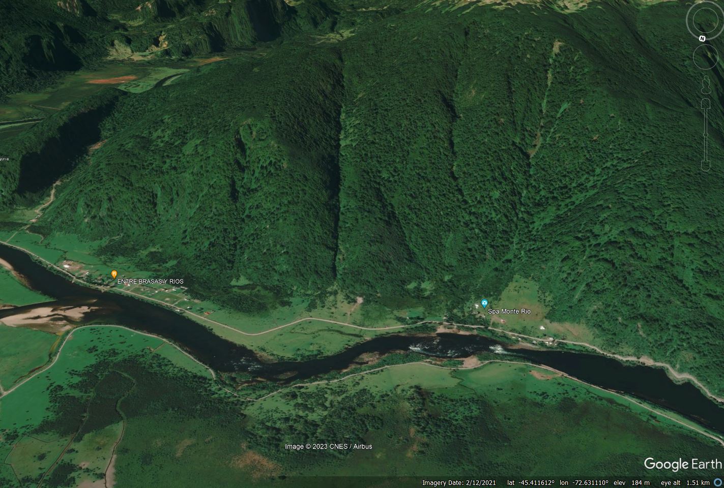
Google Earth image of the site of the large debris flow close to Lago Riesco in Chile on 11 March 2023.
.
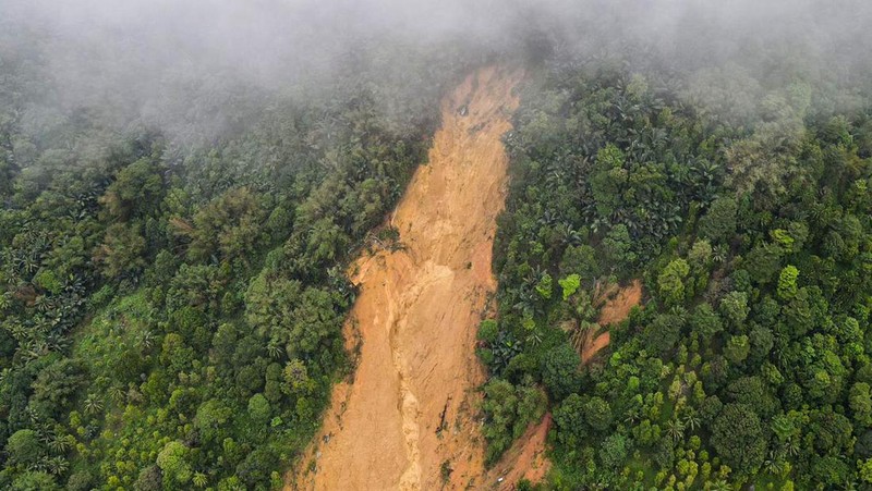
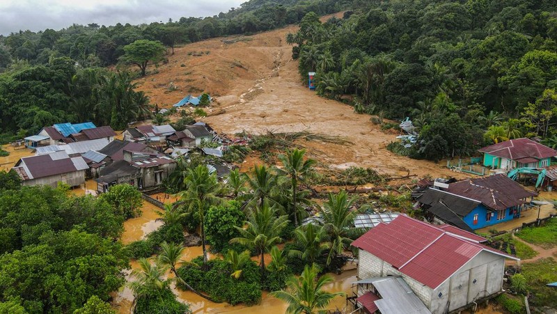
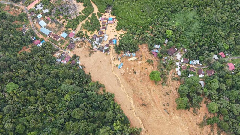
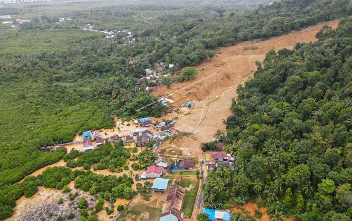
This is an extremely cloudy area, so obtaining satellite imagery of the aftermath is difficult. The debris flow appears to have originated in a deeply incised and intriguingly linear channel on the steep slopes above the road. It is notable that there is a large amount of woody debris in the flow, which might imply that there has been a significant slope failure on the margin of the channel at some point. I wonder also whether channel blockage, and then a sudden release, may have played a part here too.
Panoramic Informativa has a rather wonderful drone video of the site. Unfortunately, the vagaries of WordPress mean that I cannot embed it, but you should be able to view it here. The videographer has done an amazing job of flying a long way up the channel, although the source of the landslide is not clear.

The aftermath of the large debris flow close to Lago Riesco in Chile on 11 March 2023. Image from the Panoramica Informativa Facebook page.
.
Note that the flow has crossed a fan deposit, suggesting that this is not the first large event to be generated by this channel.
Acknowledgement
Thanks to Luis Donoso for making me aware of this event.
13 March 2023
The NRSC/ISRO Landslide Atlas of India
The NRSC/ISRO Landslide Atlas of India
The National Remote Sensing Centre (NRSC) of the Indian Space Research Organisation (ISRO) released last week a Landslide Atlas of India, which is freely available online. It provides maps of about 80,000 landslides that have been identified across India in the period between 1998 and 2022, with a particular emphasis on seasonal landslides triggered by the 2014 and 2017 monsoon seasons, as well as by the Sikkim earthquake.
The Atlas has been compiled using imagery collected from a range of sensors, including the Indian satellites IRS-1D PAN+LISS-III, Resourcesat-1, 2 & 2A LISS-IV Mx, Cartosat-1 and 2S; and international instruments such as Sentinel-1&2, Pleiades and WorldView; and through the use of aerial photographs.
One of the key results is a single map showing all of the identified landslides in India:-
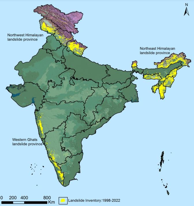
A map showing all of the identified landslides in India. Source: NRSC/ISRO Landslide Atlas of India,
.
This is fascinating map, highlighting the ways in which landslides are geographically concentrated, particularly in the northern (mountainous) areas and along the southwest margin of the country.
The atlas also provides a very interesting assessment of macro-level socioeconomic risk exposure to landslides:-
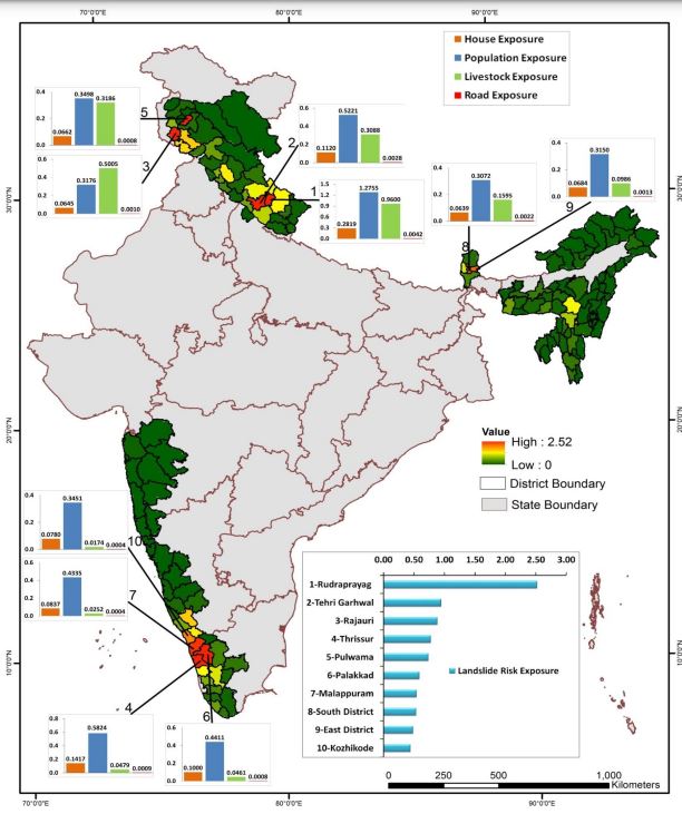
Socioeconomic risk exposure to landslides in India, based on the NRSC/ISRO Landslide Atlas of India.
.
The bar chart then indicates the ten districts with the highest socioeconomic risk exposure to landslides, of which Rudraprayag and Tehri Garhwal in Uttaranchal rank highest. This assessment feels quite experimental to me, but it is interesting. I would be fascinated to hear more details about it as the description in the atlas is quite brief.
This atlas is a really interesting initiative to highlight landslide risk in one of the most impacted countries globally. Intriguingly, the Economic Times has just published a separate article about landslide impacts in Himachal Pradesh, which is one of the high landslide impact states in the north of the country. The analysis has been undertaken by the Himachal Pradesh State Disaster Management Authority (although the report does not appear on their website).
The study has identified 17,120 landslide prone sites across Himachal Pradesh. Of these, 675 have been identified as posing higher levels of risk, and the report indicates an increasing trend with time (although I must caveat that simply comparing two years of data, as the report seems to do, is not indicative of a valid trend). Perhaps most interestingly, the Economic Times reports that:
“High intensity rainfall coupled with cutting of hill slopes or rocks at the foothills are the main reason behind the significant number of landslides, experts say. Extensive cutting of hill slopes for construction and widening of roads, blasting for tunnels, hydro projects and mining are cited as reasons behind the increase in landslides, geological expert Prof Virender Singh Dhar said.”
The point that poor construction and land management practices are the key factors behind the increasing landslide impacts in India is well made.
9 March 2023
Biases in the reporting of landslide disasters
Biases in the reporting of landslide disasters
The enduringly wonderful Save the Hills blog, which is the website of “a group of concerned citizens who are raising awareness about landslides in Darjeeling-Sikkim Himalaya of northern India“, has a very interesting article about biases in the reporting of landslide disasters in India. Written by Shreya Gurung, it draws upon research undertaken a few years ago (Eisensee and Stromberg 2007) that demonstrated that for the US Media different hazards require different levels of human loss to receive coverage. Thus, for example, a volcanic eruption with small numbers of fatalities is likely to receive more coverage than a landslide with a similar toll. The 2007 article also highlighted a well-known geographical bias, with disasters in Europe and North America commanding more attention than those is poorer countries.
Shreya Gurung has examined reporting in a reputable national Indian news source, The Times of India, and has investigated the rate of reporting of landslides in different parts of the country, focusing on Pune, Uttarakhand, Darjeeling and Mizoram. She has overlain the results on a landslide hazard zonation map of India:-

Biases in media reporting of landslides in India. Graphic by Shreya Gurung via Save the Hills.
.
The results show that whilst Uttarakhand had 1,573 news articles, Darjeeling had just 198. The author also cited working at the academic reporting of landslides by region across India (cited in the article as Abhirup et al. 2020 but actually Dikshit et al. 2020, I think), finding that Uttarakhand represents 51% of the total, with Kalimpong and Darjeeling representing 15%.
Now, this is of course not a definitive study – it is blog post after all. It would be interesting to compare these results with actual recorded landslides (my own global landslide database could be used to do this – it’s freely available). Uttarakhand has been the site of a series of terrible accidents, including the 2013 Kedarnath disaster, but there have been dreadful events in other areas too. Shreya Guring notes that many of the reports are associated with landslides on major roads, which may account for some of the bias. The clear implication is that the reporting of landslides is disproportionately weighted toward Uttarakhand, which of course is the closest of the four areas to the capital city of Delhi.
The article is rightly picking up a core issue about biases in reporting of hazards. This bias then probably translates into a misunderstanding in wider society about the range and scope of landslides. Understanding these biases, and their impacts, is an important area of research, as is approaches that could be used to correct them. Save the Hills, and Shreya Gurung, are to be commended for raising such a key topic.
.
References
Eisensee, T. and Strömberg, D. 2007. News Droughts, News Floods, and U. S. Disaster Relief, The Quarterly Journal of Economics, 122 [2], 693–728, https://doi.org/10.1162/qjec.122.2.693.
Dikshit, A., Sarkar, R., Pradhan, B., Segoni, S. and Alamri, A.. 2020. Rainfall Induced Landslide Studies in Indian Himalayan Region: A Critical Review Applied Sciences 10 [7], 2466. https://doi.org/10.3390/app10072466.
8 March 2023
Natuna: a landslide in Indonesia has killed up to 57 people
Natuna: a landslide in Indonesia has killed up to 58 people
On Monday 6 March 2023, a large landslide occurred in Natuna regency on the island of Serasan in the Riau islands of Indonesia. Rescue and recovery operations are ongoing at the time of writing, but latest reports indicate that 11 people are confirmed to have been killed and a further 47 are missing. The likelihood of finding survivors seems to be very low.
The landslide, which struck a village named Genting, as triggered by heavy rainfall.
Badan Geologi has an information page about the event, in Indonesian but Google Translate is a useful too. It indicates that three villages have been affected – Genting, Air Raya and Air Sekain. The location is identified on a map, which translates to approximately [2.5096, 109.0413]. We will need to use satellite imagery to confirm the location in due course.
Detik News has a gallery of images of the landslide, which includes this picture that apparently shows the source. It appears to be a very steep slope, with the landslide initiating in the regolith:-
The source of the 6 February 2023 landslide at Natuna in Indonesia. Image from Detik News.
.
Detik News also has this image of the lower part of the landslide:-
The lower portion of the 6 February 2023 landslide at Natuna in Indonesia. Image from Detik News.
.
Detik also has a vertical aerial image of the lower part of the landslide, showing the very high levels of destruction that the failure has induced:-
Vertical aerial image of the lower portion of the 6 February 2023 landslide at Natuna in Indonesia. Image from Detik News.
.
It appears to me that this is located at [2.5126, 109.0373], although again this will need to be confirmed.
Based on the images, this appears to be a shallow, disrupted landslide that has transitioned into a mobile flow.
Antara has an image that provides a slightly wider perspective on the lower part of the landslide:-
The lower portions of the 6 February 2023 landslide at Natuna in Indonesia. Image from Antara/Kiky Firdaus/Lmo/foc.
7 March 2023
The remarkable landslide in an olive grove near to Hatay, triggered by the Turkey earthquakes
The remarkable landslide in an olive grove near to Hatay, triggered by the Turkey-Syria earthquakes
Yesterday marked one month since the 6 February 2023 Turkey-Syria earthquakes, which have had such a devastating impact across a wide area of both countries. Investigations of the coseismic landslides continue – I recommend the Twitter account of the SLATE-landSLide Assessment TEam (@SLATE_landslide), a group of Turkish landslide specialists who are providing updates on their work investigating the major failures.
One landslide that has attracted some interest is the large failure in an olive grove near to Tepehan, which some people have termed the Hatay landslide. The location of the failure is [36.161, 36.222]. My friends at Planet have very kindly captured before and after satellite imagery of the failure using the high resolution SkySat instrument. This is the site before the landslide:-
Satellite image of the site of the landslide in an olive grove near to Tepehan in Hatay, Turkey. Image copyright Planet, used with permission, collected on 21 November 2021.
.
Whilst this is the same site after the earthquake:-
Satellite image of the landslide in an olive grove near to Tepehan in Hatay, Turkey. Image copyright Planet, used with permission, collected on 22 February 2023.
.
I have created a slider that should allow you to compare the before and after images:-
.
In the media there has been some confused reporting about this landslide, with some mistaking the landform for the fault rupture. This is a block slide type of failure, probably on a weak layer in a dip slope, which has allowed parts of the olive grove to remain intact despite large displacements. This block diagram from the USGS explains the concept well:-
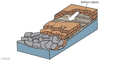
USGS conceptual diagram of a block slide landslide.
.
Robin Lacassin has a good tweet that highlights the main features of the landslide close to Hatay:-
https://twitter.com/RLacassin/status/1630186366628765696
.
There is quite a nice video on Youtube showing the aftermath of the landslide:-
.
I will look forward to reading more about this failure once it has been investigated fully.
.
Acknowledgement and reference
Many thanks once again to the wonderful team at Planet.
Planet Team (2023). Planet Application Program Interface: In Space for Life on Earth. San Francisco, CA. https://www.planet.com/
6 March 2023
Luccombe: the individual impact of coastal landslides
Luccombe: the individual impact of coastal landslides
The BBC has recently featured a story on its news website about the development of a landslide in the coastal community of Luccombe on the Isle of Wight, in the south of England. This is an area that is notorious for coastal failures, and there is some good information online about the causes and impacts of the failures.
The BBC story features George Gardiner, an elderly resident whose house is being affected by the rearward propagation of a landslide. The article includes this image of the house and the development of a new set of tension cracks and scarps:-
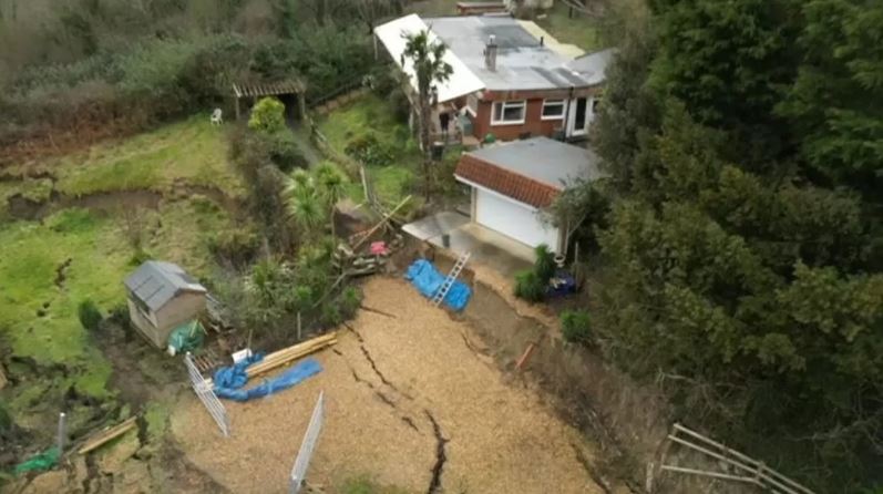
The tension cracks and scarps near to a house in Luccombe on the Isle of Wight. Image from the BBC.
.
The location of the house is, I believe [50.613, -1.177]. This is a Google Earth image of the site, collected in 2019:-
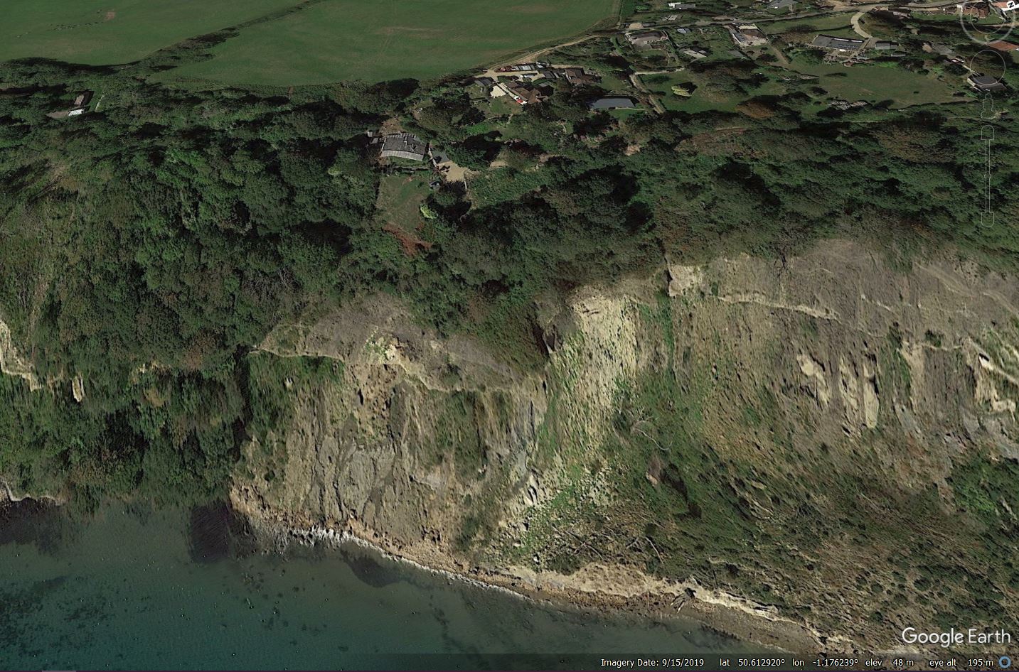
Google Earth image of the site of the landslide at Luccombe on the Isle of Wight.
.
The Isle of Wight County Press also has a gallery of images of the site, collected in January, showing the development of the scarps. It is clear that the situation has deteriorated considerably in the two months since then. There is also a more recent article published by On the Wight about the problems.
This case highlights one of the very serious challenges facing those managing landslides. Mr Gardiner wishes to be able to stay in his home, which is completely understandable. There is a strong line of argument that he should be able to do so if he is aware of the risks and is willing to accept them. However, the counter argument is that the behaviour of the slope is unpredictable and the situation could deteriorate quickly. If so, Mt Gardiner could require emergency assistance, possibly in very poor weather. This would place the lives of the fire and rescue workers, and the police, at high risk too. The recent case in New Zealand, in which two volunteer fire and rescue staff were killed, highlights the potential consequences.
In the case of Luccombe, the authorities need to balance the risks. This is not straightforward.
3 March 2023
Planet images of the Alxa League coal mine landslide
Planet images of the Alxa League coal mine landslide
My friends at Planet have very kindly acquired a high resolution (SkySat) image of the 22 February 2023 landslide at a coal mine at Alxa League in China. Typically, of course, this event has effectively disappeared from the news, even in China – I can find no real updates on the recovery operations since the call for improvements in coal mine safety on 25 February.
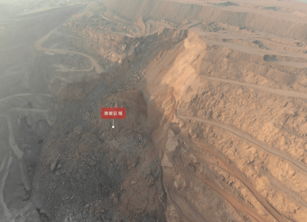
This is the SkySat image, collected on 28 February 2023, that captures the mine site and the landslide:-
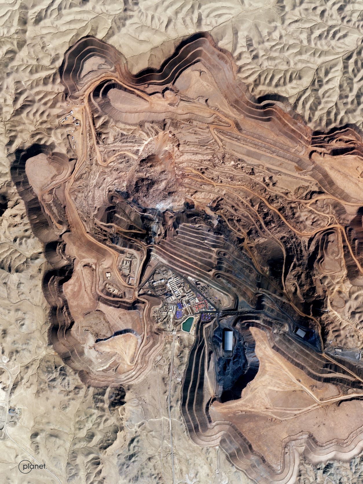
SkySat image of the 23 February 2023 coal mine landslide in Alxa League, China. Image copyright Planet, used with permission.
.
The image below provides more detail of the landslide itself:-
SkySat image of the detail of the 23 February 2023 coal mine landslide in Alxa League, China. Image copyright Planet, used with permission.
.
The crown of the landslide is to the north, so the landslide has moved towards the foot of the image. The imagery captures the scale of the landslide and the large boulders that it contains. A haul road has been built across the landslide toe, and there is some evidence of attempts to excavate the toe on the eastern side. Overall, though, the image does not indicate a huge amount of excavation, which may suggest that attempts to recover the remains of those lost have been fruitless.
For reference, this is the site of the landslide, as captured in a SkySat image on 23 November 2022:0
SkySat image of the site of the 23 February 2023 coal mine landslide in Alxa League, China. Image copyright Planet, used with permission.
.
At this point there was no obvious indication of the development of a developing slope failure. The huge amount of equipment at the toe of the slope is notable though.
I have tried to create a slider that should allow the two images to be compared:
.
This landslide highlights the continued hazards associated with poorly regulated mining activities worldwide. These types of landslides should not be causing large-scale loss of life.
.
Acknowledgement and reference
Many thanks once again to the wonderful team at Planet. Their kindness is remarkable.
Planet Team (2023). Planet Application Program Interface: In Space for Life on Earth. San Francisco, CA. https://www.planet.com/
28 February 2023
Joshimath: new satellite imagery and ongoing issues with the movement of the landslide
Joshimath: new satellite imagery and ongoing issues with the movement of the landslide
The current phase of the Joshimath landslide crisis in India is now almost two months old, with little sign of a permanent solution to the problem. This remains a case study in poor hazard communication – for example, the panel set up to investigate the hazard has still to release a report, although it does appear to have been submitted to the Prime Minister’s Office. The Economic Times reports that “[t]he committee has flagged concerns about potential problems in the adjoining areas and directed the state authorities to take immediate steps, according to officials”, whatever that means. Meanwhile, another group of experts visited the site yesterday, but I am unsure as to how this relates to the original panel.
Demolition of two large hotels at Joshimath, Mount View and Malari Inn, has now been completed. Planet has managed to capture a high resolution satellite image of the Joshimath landslide – this is shown below, draped onto the Google Earth DEM,with the Hotel Mount View marked:-
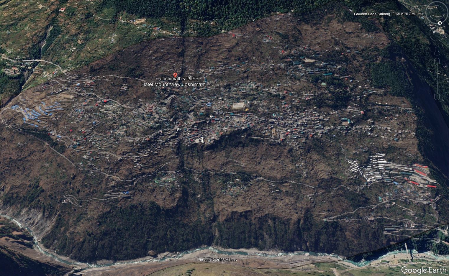
High resolution image of the Joshimath landslide draped onto the Google Earth DEM. Image copyright Planet, captured 27 February 2023, used with permission.
.
Below is the image in more conventional format, for reference:-
High resolution image of the Joshimath landslide. Image copyright Planet, captured 27 February 2023, used with permission.
.
Al Jazeera has a very good article about the wider implications of the rapid pace of poorly controlled development in the Indian Himalayas, which includes some beautifully framed images of the damage to Joshimath. It includes a description of the village of Haat, which was located at [30.426, 79.419]. This is a Google Earth image of the site of the village, collected on 9 November 2022:-
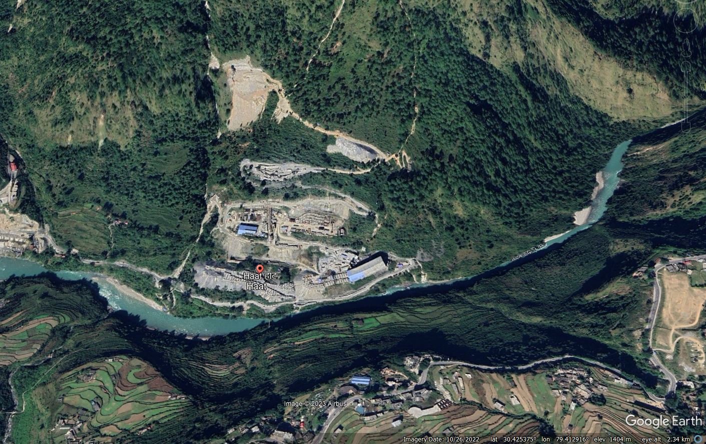
Google Earth image of the site of the village of Haat in northern India.
.
The Al Jazeera article makes this point about Haat:-
Haat, along the Alaknanda River, was once a sacred hamlet where Adi Shankaracharya is said to have established another temple in the eighth century.
Today, it is a dumping site for waste and a storage pit for construction materials after the village was acquired in 2009 by an energy enterprise to build a hydropower project.
The Laxmi Narayan temple is the only part of the village still standing. All of its residents were relocated, said Rajendra Hatwal, once the village chief who now lives in another town.
Hatwal and a few others still check in on the temple. A caretaker, who refused to leave, lives in a makeshift room next to it. He sweeps the ground, cleans the idols and prepares tea for the odd guest who comes through.
The point is well made – the image clearly shows waste being stored in large volumes on the slope in at least three locations. This looks to be somewhat hazardous.
Meanwhile, slope deformation is being noted in other locations in the Indian mountains, such as Doda in Jammu and Noklak in Eastern Nagaland.
.
Reference and acknowledgement
Thanks as ever to my friends at Planet for providing fabulous imagery again.
Planet Team (2023). Planet Application Program Interface: In Space for Life on Earth. San Francisco, CA. https://www.planet.com/
27 February 2023
Kandersteg: a massive rock slope failure in Switzerland caught on video
Kandersteg: a massive rock slope failure in Switzerland caught on video
On 23 February 2023 a large rock slope failure occurred in Kandersteg in the Bernese Oberland in Switzerland. The failure, which had a volume in the range of 15,000 to 20,000 cubic metres, was from the Allmenalp. The rock slope collapse had been anticipated, so that no loss of life occurred, and there was no damage to buildings.
The event was captured on several videos, of which this is probably the best:-
.
SRF News has a good article about the event, in German, which notes that the block was being monitored using radar, allowing a warning to be issued. The article includes a short archive film about the use of monitoring in the area.
The location of the rockfall is about [46.491, 7.658]. This image shows the aftermath of the rockfall:-
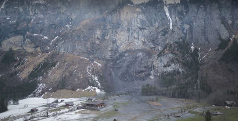
The site of the 23 February 2023 rockfall at Kandersteg in Switzerland. Image via RTS.
.
This is an area of frequent rock slope failures. Previous events have occurred from Allmenalp in 2008 and in 2018, for example. On the other side of the valley is the Spitzer Stein area above Lake Oeschinen, in which active rock slope deformation is occurring. This is a much larger volume – about 20 million cubic metres. Geotest has a nice article about its work monitoring the site, whilst Swissinfo has a short video showing the scale of the hazard at this location.
.
Acknowledgement
Thanks to Doris Hermle of TUM, who made me aware of this event.
24 February 2023
The 22 February 2023 landslide at a coal mine at Alxa League, China
The 22 February 2023 landslide at a coal mine at Alxa League, China
On 22 February 2023 a large landslide occurred at an open cast coal mine in Alxa League in Inner Mongolia, China. It appears that this landslide has killed 53 people, the remains of six of whom have been recovered to date. A further six people were rescued. Of course these numbers need to be treated with skepticism.
The landslide appears to have occurred in a sequence of two events. The first, smaller, failure occurred at 13:00, followed by a second, larger, landslide at 18:44. The failure is remarkable for a series of videos that have emerged.
The set of videos, which are validated, are extraordinary. This is likely to be the main collapse:-
.
There is an interesting article, in Mandarin, about the landslide on the coal.in-en website. It describes the scale of the failure:-
The accident took place in the west mining area of Xinjing Coal Mine. According to CCTV news reports, the mountain on the northern slope of the west mining area collapsed as a whole. The clear vertical height of the mountain is 180 meters. After the landslide, a mound of muck with an east-west direction of 500 meters, a north-south direction of 200 meters and a net height of about 80 meters was formed.
The article indicates that the mine has suffered two previous fatal landslides, in 2015 and 2016. The volume of this failure is estimated to be about 3.5 million cubic metres. Recovering the victims from the toe of such a large failure is going to be enormously difficult,
The location of the landslide is [37,979, 105.645]. It is clearly visible on Planet Labs imagery, although the resolution is too low to be able to discern much detail.
Sohu has this image of the aftermath of the landslide:–
The aftermath of the landslide at Alxa League in Inner Mongolia, China. Image from Sohu.
.
There is of course the customary call for improvements in safety standards in Chine mines in the aftermath of the landslide. This is a regular occurrence in China, but little seems to change.
 Dave Petley is the Vice-Chancellor of the University of Hull in the United Kingdom. His blog provides commentary and analysis of landslide events occurring worldwide, including the landslides themselves, latest research, and conferences and meetings.
Recent Comments