
30 March 2023
Buriticupu: a town with a chronic gully and landslide problem in Brazil
Buriticupu: a town with a chronic gully and landslide problem in Brazil
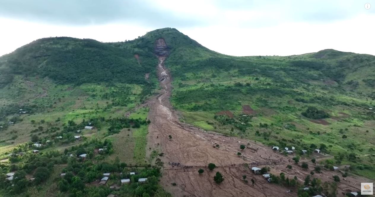
Buriticupu is a town in municipality in Maranhão in Brazil, located on a plateau with steep slopes, founded in 1994. Its population is about 73,000 people. Reuters has a very nice video about a chronic landslide problem that is affecting the town, with the issues rapidly escalating over the last year:-
.
Google Earth imagery (the town is at [-4.327, -46.457]) shows that the town has landslide problems on many slopes -some reports suggest 26 different locations. The image below is one of the worst affected areas, as captured in 2014, before the problem became too serious:-
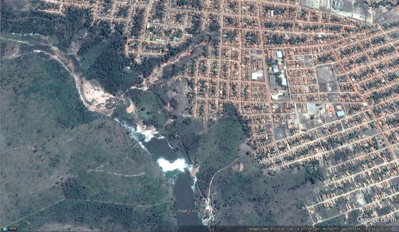
Google Earth imagery of the site of some of the landslide problems at Buriticupu in Brazil. Image from 2014.
.
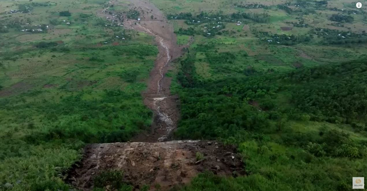
This is the same site in July 2022:-
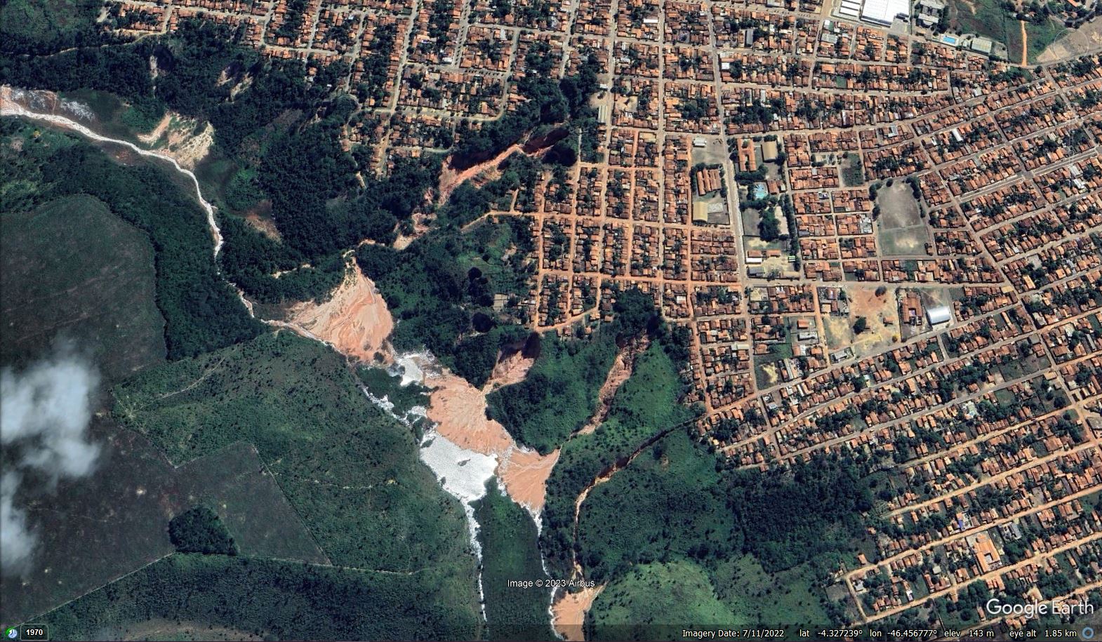
Google Earth imagery of the site of some of the landslide problems at Buriticupu in Brazil. Image from July 2022.
.
I have created a slider to allow the sites to be compared:-
.
Estadao has a short article about the issues in Buriticupu in Portuguese. It includes this image:-
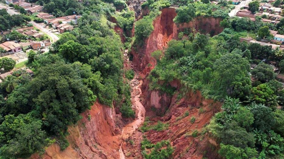
One of the landslides at Buriticupu in Brazil. Image by Mauricio Marinho via Reuters and Estadao.
.
These issues at Buriticupu are primarily rapid headward and lateral erosion of gullies, driven by toe erosion and then slope failure, as the image above shows. The materials appear to be deeply weathered (hence the red colour), and thus will be weak. The Estadao article ascribes the problems to ‘deforestation, disorderly occupation, relief and sandy soil’.
In my experience, these problems are often associated with inadequate water management in the towns, both in terms of water supply and sewage disposal, and the control of surface drainage from the roads and pavements. It would be interesting to know if that is the case here. Unfortunately, once these problems start they are difficult to stop unless there is substantial engineering intervention into the gullies themselves, along with good water management in the town.
29 March 2023
The Novato landslide in California: digital elevation model data demonstrates a much older, larger landslide
The Novato landslide in California: digital elevation model data demonstrates a much older, larger landslide
Loyal reader and long time online friend Funkenbeachin has extracted the 1 metre digital elevation model (DEM) data for the site of the Novato landslide in California. He has made a a video that shows the site, which he’s posted to Youtube:-
.
This video really demonstrates the power of DEM data, which highlights beautifully that the most recent slide is a reactivation of the lower portion of a much larger, ancient landslide. I wonder whether the engineers who designed and constructed the slope on the uphill side of the road were aware of this. This landslide can clearly be seen in the still from the video below:-
1 m DEM data for the site of the Novato landslide in California. Still from a video posted to Youtube by loyal reader funkenbeachin.
.
This is landslide country – there are many other landslides visible in the image above, a consequence of active tectonics that have created a dynamic landscape, weak rocks, regular high intensity rainstorms and occasional earthquakes.
There are certainly lessons to be learnt from the Novato landslide.
28 March 2023
Alausí: a massive landslide in Ecuador
Alausí: a massive landslide in Ecuador
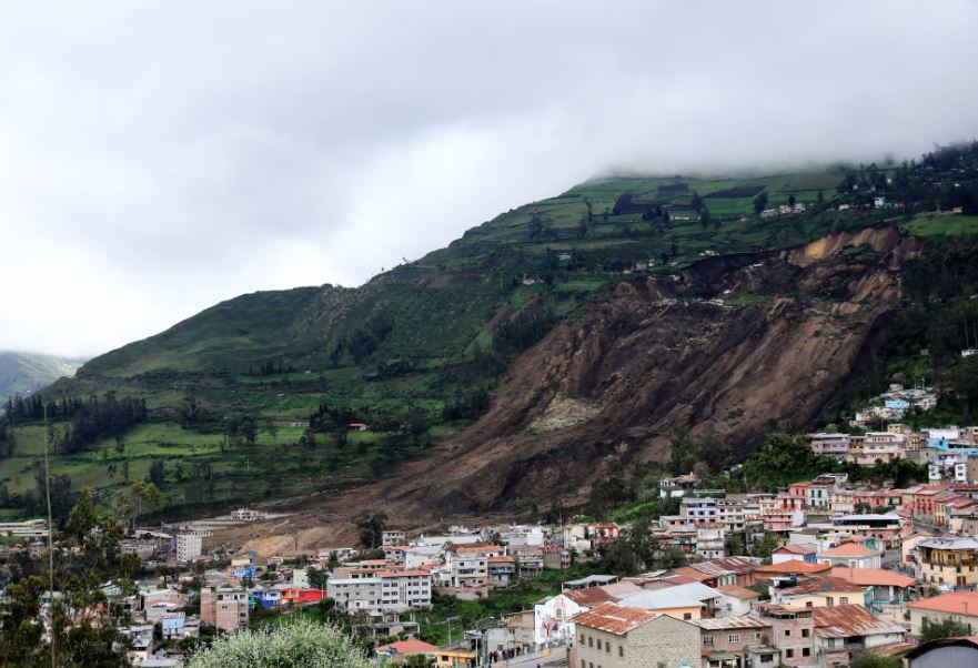
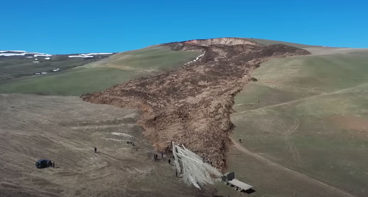
The 26 March 2023 landslide at Alausí in Ecuador has attracted considerable attention, having buried a neighbourhood of the town. At the time of writing the confirmed loss of life is seven people, with a further 23 having been injured. It is reported that 64 people are missing, although there will be considerable uncertainty in that number. Earlier reports of 16 fatalities are now thought to be incorrect.
The best overall view of this very large landslide is a drone video collected by Edwin Salazar that has been widely tweeted:-
https://twitter.com/canarvaezm/status/1640328603198971907
.
The drone successfully captures a very deep-seated, rotational landslide in comparatively homogenous, but clearly weak, rocks. I would suspect that these might be volcanic materials?
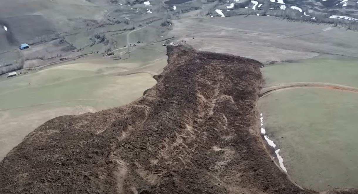
Meanwhile, AP has a remarkable image of the toe of the landslide, and the immense damage that it has caused to the town of Alausí:-
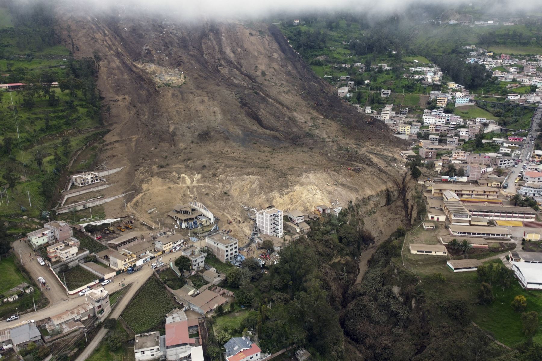
The toe of the very large 26 March 2023 landslide at Alausí in Ecuador. Image by AP via Andina.
.
This is roughly the same perspective from Google Earth, giving an idea of what has been lost in this lower portion:-
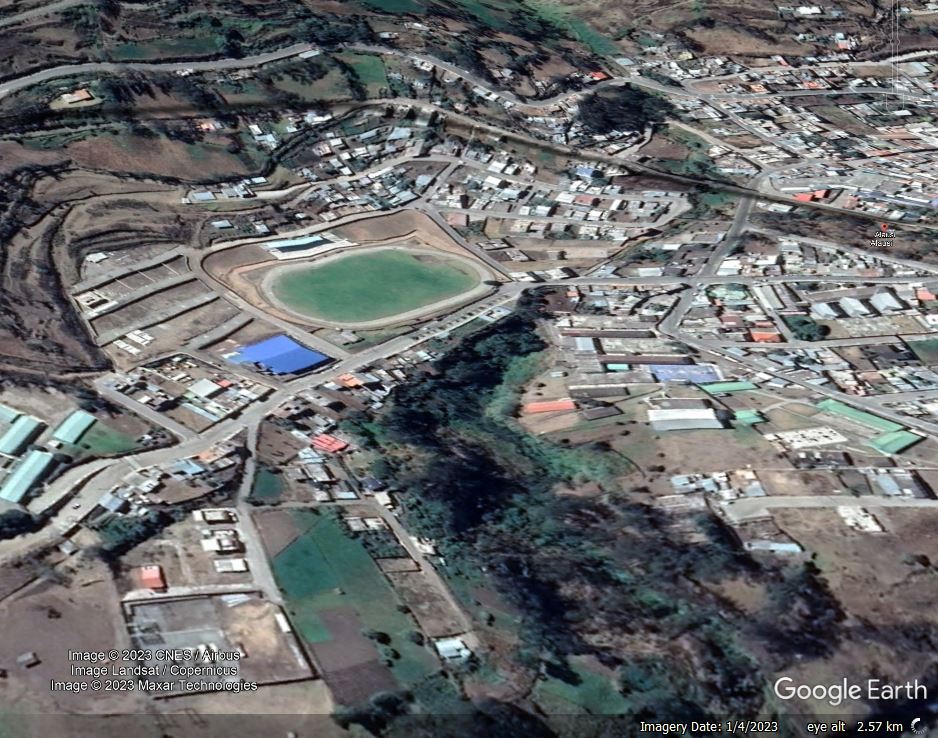
Google Earth image of the site of the very large 26 March 2023 landslide at Alausí in Ecuador.
.
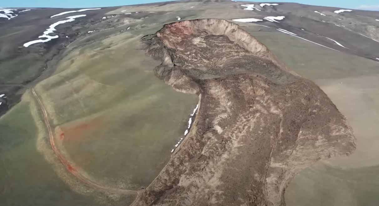
The location of the landslide is [-2.193, -78.843]. This is the best image that I have found that shows the entire landslide:-
The very large 26 March 2023 landslide at Alausí in Ecuador. Image by REUTERS/Karen Toro.
.
Reports indicate that the area has suffered heavy rainfall in recent days, which is also hindering the rescue operations. The area has been on yellow alert for landslides since 15 March 2023.
In terms of Alausí itself, there are reports that cracks started to appear in the area of the landslide in December 2022, and that irrigation water had ceased to flow in the area. The reports also indicate that some monitoring was ongoing at the site.
It is interesting to take a wider perspective on the area around Alausí:-
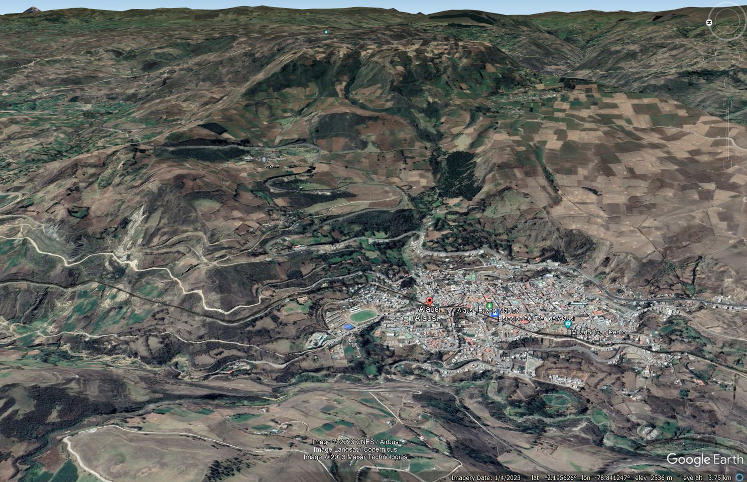
Google Earth image of the landscape around Alausí in Ecuador.
.
This is a landscape dominated by landslides. On the left side of the image are multiple shallow failures on steep slopes, many of which are affecting the road. But on the steep slopes around Alausí there are multiple arcuate scars that probably mark the source zones of previous landslides, many of which would have been much larger than the event on Sunday. The largest of these might lie in the upper portion of the in the centre of the image, where there is a very large, arcuate scar and, downslope to the right, the possible remains of a degraded landslide block. This is, of course, only a hypothesis – more detailed mapping would be needed to confirm the theory.
27 March 2023
Novato: an interesting landslide triggered by heavy rainfall in California
Novato: an interesting landslide triggered by heavy rainfall in California
Last week, the latest in a long series of large storms struck California, triggering another round of flooding and landslides. One particularly interesting slope failure occurred at Novato in Marin County. The San Francisco Chronicle has a nice image of the aftermath:-
The aftermath of the landslide in Novato, California. Image from the San Francisco Chronicle.
.
A Tweet by Sarah Klieves, a senior producer for NBC Bay Area, provides the best perspective though:-
Our @nbcbayarea SkyRanger flew over a landslide that crumpled a section of Redwood Blvd near Olompali State Historic Park. This is the only public road into the park, so rangers say it will be closed for awhile. pic.twitter.com/saQqDMff9d
— Sarah Klieves (@sarah_klieves) March 24, 2023
.
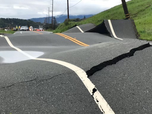
This is a view from that video, showing the landslide:-
The landslide at Novato, California. Image from a Tweet by Sarah Klieves of NBC Bay Area.
.
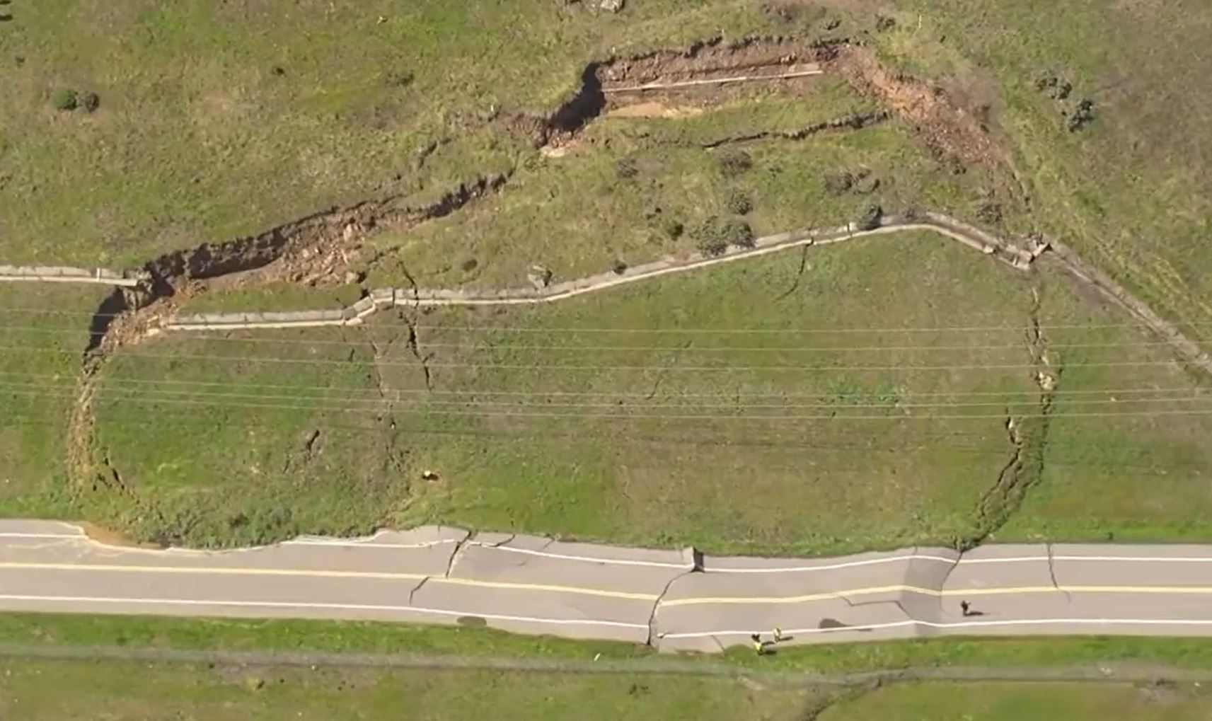
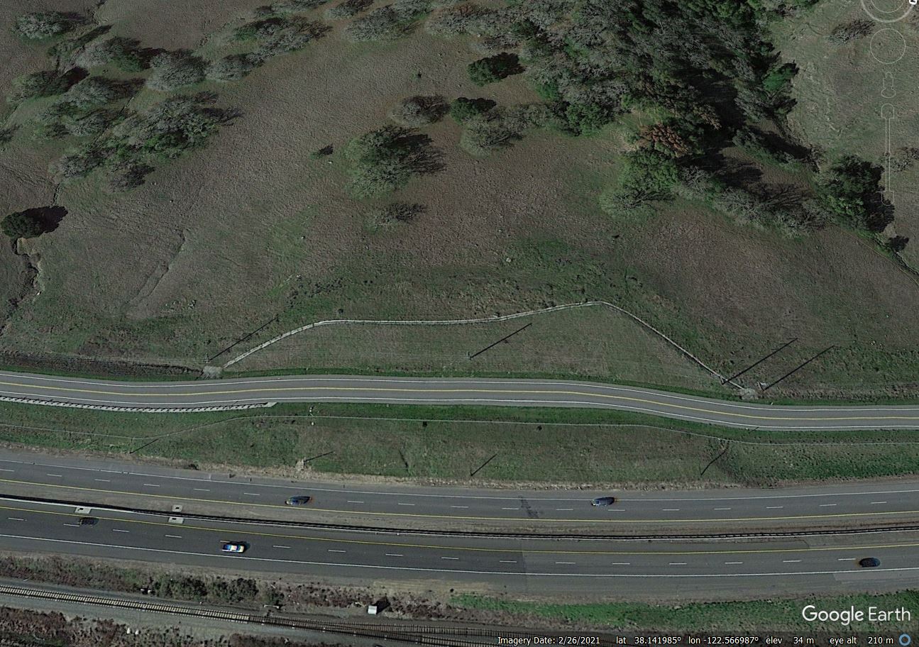
The location of the landslide appears to be [38.1444, -122.5652]:-
Google Earth image of the site of the landslide at Novato, California.
.
Interestingly, Redwood Boulevard, which is the road damaged by the landslide, was constructed in 2015. A Google Earth image from March that year shows that the slope at the site of the landslide was cut and reprofiled, and that drains were installed:-
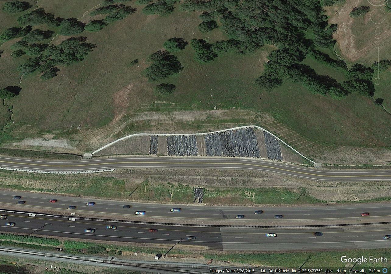
Google Earth image of the site of the landslide at Novato, California in March 2015, showing engineering works underway at the site.
.
It is interesting that at this site the slope is a little steeper than in the adjacent areas, which presumably is the reason for the additional works, including the drains. That failure is a classic slump. Fortunately the toe has not extended to the main highway, and the limited mobility of the debris has meant that this road is unaffected. However, the landslide has caused disruption to a watermain and to a gas pipeline.
24 March 2023
A remarkable landslide at Karl Marx village, in Jalpak-Tash, Kyrgyzstan
A remarkable landslide at Karl Marx village, in Jalpak-Tash, Kyrgyzstan
On the night of 22 March 2023 a landslide was triggered at Karl-Marx village in Jalpak-Tash rural municipality, Uzgen in Kyrgyzstan. The landslide is reported to be 1 million cubic metres. AKI Press has a posted a drone video of this event onto Youtube – it is breathtaking:-
.
This is a still from the video:-
The 22 March 2023 landslide at Karl-Marx in Jalpak-Tash rural municipality in Kyrgyzstan. Still from a video posted to Youtube by AKI Press.
.
The image below shows the upper portion of the landslide, including the source area:-
The source area of the 22 March 2023 landslide at Karl-Marx in Jalpak-Tash rural municipality in Kyrgyzstan. Still from a video posted to Youtube by AKI Press.
.
Whilst the image below shows the landslide track:-
The track of the 22 March 2023 landslide at Karl-Marx in Jalpak-Tash rural municipality in Kyrgyzstan. Still from a video posted to Youtube by AKI Press.
.
The head scarp area of the Jalpak-Tash landslide shows a reasonably deep seated landslide source, with possibly a minor rotational component to the failure. The main part of the landslide track appears to me to be an earthflow. The video seems to indicate that the landslide was still creeping at the time of the failure.
The location of this landslide is unclear to me, but research suggests that it might be close to Kurbu-Tash, which is at [40.611, 73.293]. This area suffered a large landslide that I highlighted in 2017, which was not dissimilar to the 22 March 2023 event. This remains to be confirmed.
An AKI Press article reports that an emergency situation has been declared for the village, with the residents of 18 houses having been evacuated, but that the risk is considered to be low. The rate of movement has been recorded at about 3 metres per hour.
The trigger for this landslide is not given, but this will be snowmelt season in this part of Kyrgyzstan. The 2017 landslide also occurred in the Spring.
23 March 2023
Planet animations of a paraglacial landslide on a tributary of the Klutlan Glacier in Alaska
Planet animations of a paraglacial landslide on a tributary of the Klutlan Glacier in Alaska
A very interesting area of current research is the ways in which slopes are behaving in the vicinity of glaciers in high mountain areas. In most such environments, glaciers are retreating. There is some evidence that some slopes respond by deforming, possibly assisted by the thawing of permafrost at some times of the year.
Bretwood Higman, known as Hig, is a geologist and data scientist based in Alaska (there is a great profile of Hig on YourStory) who has been studying these processes for a number of years. Hig recently contacted me to highlight a site in Alaska, on a tributary of the Klutlan Glacier, that he has identified that is displaying very active deformation. The location is [61.4881, -141.1884] – there is a really good image on the Living Atlas site:-
A landslide on a tributary of the Klutlan Glacier in Alaska. Image from the Living Atlas site.
.
Hig has made the following observation about the landslide:-
In some ways this is a very typical landslide – a rotational failure with a very steep head scarp extending well beneath the surface of a thinning glacier. I’ve documented dozens of similar sites around Alaska. However, the retrogressive nature of the initial failure, opening huge tension cracks, is unusual. More typical would be antiscarps indicating a flexural topple.
Hig has put together a Planet animation that shows the development of the Klutlan Glacier landslide, which you can see here. It’s really cool:-
https://www.planet.com/stories/klutlan-trib-landslide-LruA13-VR
As you can see, the landslide started to develop in July 2022. Before the landslide disappeared below the winter snow, it was about 400 m from crown to the junction with the glacier and about 650 m wide.
It will be fascinating to see how this develops over the coming spring and summer – based on last years imagery of the area of the Klutlan Glacier, it is likely to start to re-emerge in April and May.
.
Acknowledgement
Thanks to Hig for his work on this great site.
Planet Team (2023). Planet Application Program Interface: In Space for Life on Earth. San Francisco, CA. https://www.planet.com/
21 March 2023
First Planet satellite images of the landslides in Malawi from Cyclone Freddy
First Planet satellite images of the landslides in Malawi from Cyclone Freddy
Yesterday, I highlighted that Cyclone Freddy has triggered multiple damaging landslides in Malawi. I have started to look at the Planet imagery of the potentially affected areas, particularly in the area of Chiradzulu, which is reported to have been badly impacted. This is an area that is heavily affected by cloud, so obtaining good imagery is not straightforward. It is likely that it will be some days or even weeks before we get a full picture.
However, this is the Chiradzulu Forest Reserve, with an image collected on 19 March 2023. The centre of this image is at about [-15.693, 35.161]:-
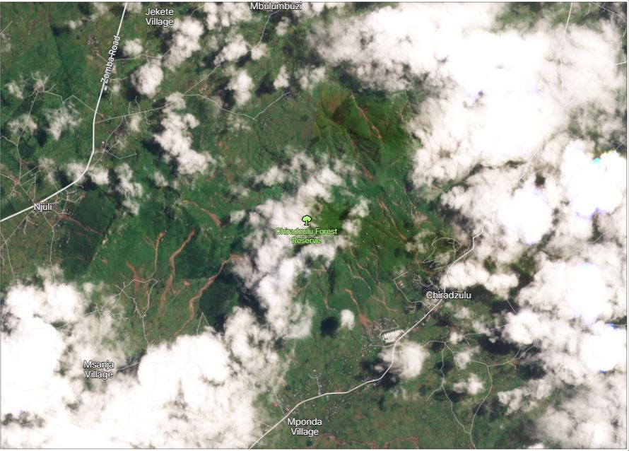
The area affected by landslides triggered by Cyclone Freddy in Chiradzulu Forest Reserve, Malawi. Image copyright Planet, used with permission, collected on 19 March 2023.
.
For reference, this is the same area in an image collected before Cyclone Freddy, on 21 February 2023:-
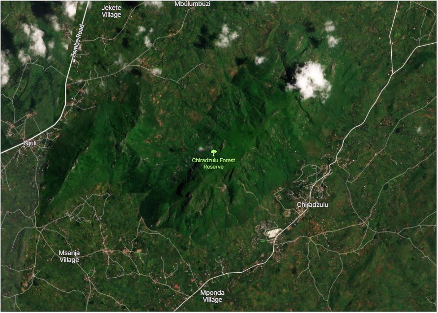
The area affected by landslides triggered by Cyclone Freddy in Chiradzulu Forest Reserve, Malawi. Image copyright Planet, used with permission, collected on 21 February 2023.
.
I have created a slider to allow the images to be compared easily:-
.
.
The Planet satellite imagery shows multiple long run out flows, most of which appear to have initiated as shallow landslides on the higher slopes. Many have involved multiple landslide sources that have merged in channels to form more destructive landslides on the lower slopes. In several locations the landslides have impacted the settlements, as shown in this area of the image:-
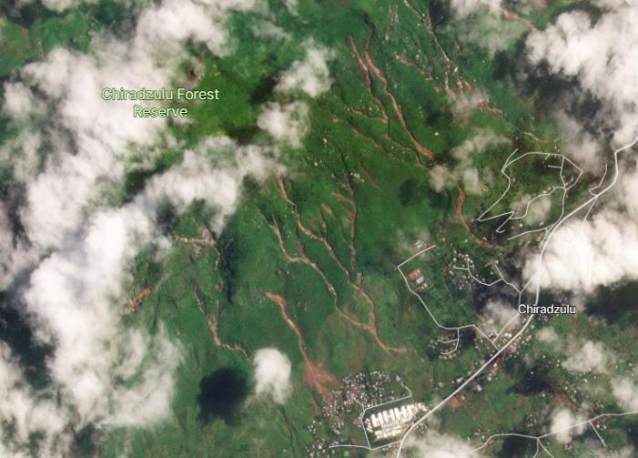
One of the areas most affected by landslides triggered by Cyclone Freddy in Chiradzulu Forest Reserve, Malawi. Image copyright Planet, used with permission, collected on 19 March 2023.
.
There is also evidence of landslides in other parts of the area too. On the western flanks of Mount Soche to the south of Blantyre, there is the landslide shown below (the location is [-15.842, 35.018]). Whilst the image is affected by cloud, and the landslide is on the very edge of the area captured, it appears that this landslide has run out through the urbanised area:-
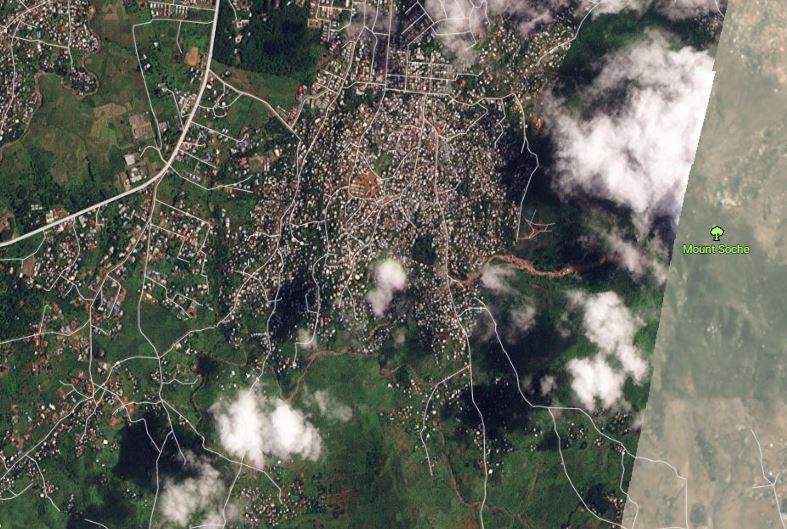
A landslide triggered by Cyclone Freddy on the flanks of Mount Soche in, Malawi. Image copyright Planet, used with permission, collected on 19 March 2023.
.
Whilst the imagery is insufficiently good to be sure, I am reasonably confident that there are further landslides in Malabvi Forest Reserve, located at [15.846, 35.136]. This post on Facebook would seem to support that assumption.
Whilst we await better imagery, it is clear that this area has been affected by dreadful landslides. Sadly, this is not the first time. Loyal reader Yannick Thiery from BGRM in France kindly contacted me to note that a similar landslide was triggered near to Chiradzulu by Cyclone Idai in March 2019. The location was reported to be [-15.683, 35.674].
.
Reference and acknowledgement
Planet Team (2023). Planet Application Program Interface: In Space for Life on Earth. San Francisco, CA. https://www.planet.com/
20 March 2023
Mtauchira: a devastating landslide in Malawi, triggered by Cyclone Freddy
Mtauchira: a devastating landslide in Malawi, triggered by Cyclone Freddy
During February and March 2023, Cyclone Freddy tracked across the Indian Ocean, bringing widespread but under-reported destruction to Mauritius, Reunion, Madagascar, Mozambique, Malawi and Zimbabwe. It is estimated that over 800 people have been killed or are missing as a result of the storm, and more than a million people have been directly impacted. As usual, most of the destruction was caused by water, of which landslides were a significant part.
Reuters has a video story about the village of Mtauchira in Malawi, which was devastated by a landslide triggered by heavy rainfall associated with Cyclone Freddy. Yahoo has some text about the landslide too, indicating that it killed 32 people and left a further 18 missing. The video should be visible here:-
.
This image, taken from the video, is a stunning illustration of the impact of the failure:-
The landslide at Mtauchira in Malawi, triggered by Cyclone Freddy. Still from a Reuters video posted to Youtube.
.
Whilst this is a view from the crown of the landslide:-
A view from the crown of the landslide at Mtauchira in Malawi, triggered by Cyclone Freddy. Still from a Reuters video posted to Youtube.
.
This clearly started as a shallow landslide on a steep, deforested slope. The main body of the landslide would be termed in Hong Kong as an open hillslope landslide, taking the form of a debris flow. It is clear that the initial failure has entrained a large volume of colluvium from the slope to create the main landslide. The devastating impact on the houses at the foot of the slope is clear.
At the moment I am unsure as to the location of Mtauchira – it does not seem to appear in the geonames databases that I usually use.
Separately, the Secretary General and CEO, of the International Federation of Red Cross and Red Crescent Societies (IFRC), Jagan Chapagain, tweeted this video of a mudflow in Malawi, also triggered by Cyclone Freddy. The location of this event is not specified, but it illustrates the destructive power of these landslides:-
Tropical Cyclone #Freddy made landfall in Malawi causing widespread devastation.
Reports indicate that the cyclone disrupted lives and livelihoods of too many people.
The IFRC is working with @MalawiRedCross to provide support to those affected. pic.twitter.com/cmuySJpUmp
— Jagan Chapagain (@jagan_chapagain) March 14, 2023
17 March 2023
The 8 March 2023 rockslide and train derailment in Sandstone, West Virginia
The 8 March 2023 rockslide and train derailment in Sandstone, West Virginia
On 8 March 2023 a rockslide triggered the derailment of a coal train near to Sandstone in West Virginia, USA. AP has an article that describes the event, which includes this image of the aftermath:-
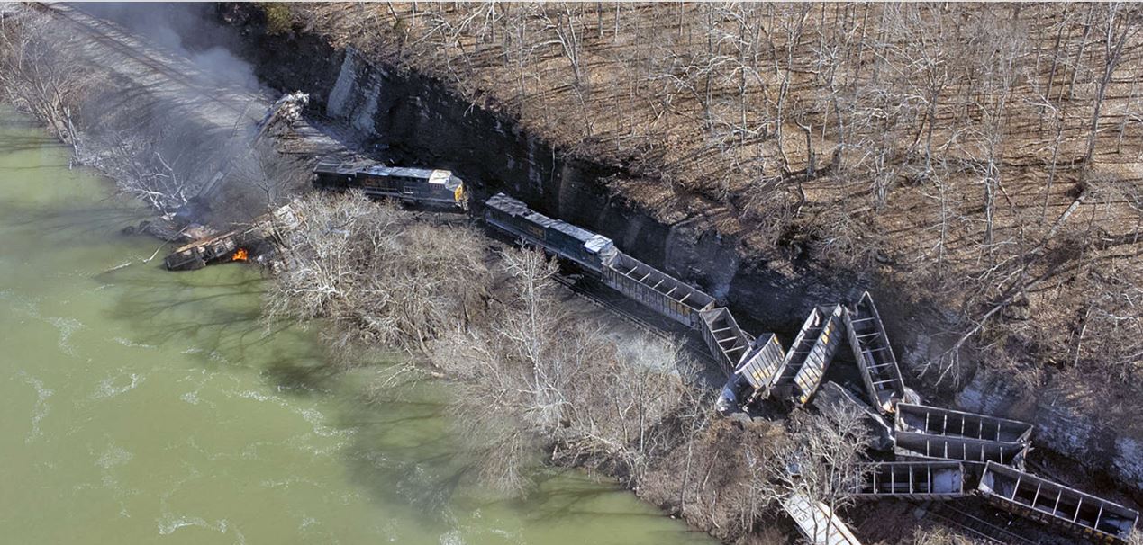
The aftermath of the 8 March 2023 rockslide and train derailment near to Sandstone in West Virginia. Image from Jenny Harnish/The Register-Herald via AP.
.
The rockslide that triggered the derailment was small, as the image above shows. However, it was sufficient to derail all four locomotives and nine coal cars, according to a statement by the train operator, CSX. The front locomotive, which was transporting three members of the train crew, caught fire. All three people escaped, although they were injured.
The track has now been cleared and has reopened.
The image above shows the fresh scar from the small landslide that triggered the derailment. It is very interesting to note the devastating effect that such a comparatively minor failure can inflict. As I have highlighted previously, landslides and trains are a challenging combination.
.
Acknowledgement
Many thanks to Matthew Eynon for bringing this one to my attention.
16 March 2023
The relationship between GDP and fatal anthropogenic landslides in China
The relationship between GDP and fatal anthropogenic landslides in China
One of the interesting observations Melanie Froude and I noted in our work on global fatal landslides (Froude and Petley 2018) was that the long term trend in China was surprising. In the early period of our work we saw a steady increase in the number of fatal landslides in China, but in the latter part of the study period we saw a decline. We were unsure as to how we could interpret this, in part because we did not know whether it was a real signal (reporting in China is controlled, so we thought it could be that the data was inconsistent).
A new study (Zhang et al. 2023) has compiled and analysed a dedicated fatal landslide database for China, which is really welcome. The research team is based in Zhejiang University, so the dataset is much more likely to be reliable. The study period was 1940 to 2020, although clearly the data quality for the early years of this period is inconsistent. As a result, there is a more detailed analysis of the period from 2000 to 2020.
Interestingly, like us the authors noted that fatal landslide occurrence is declining in China. Indeed, in their data there was a steady upward trend from 2000 to 2010, and a downward trend thereafter. This is the annual total, broken down by geographical region:-
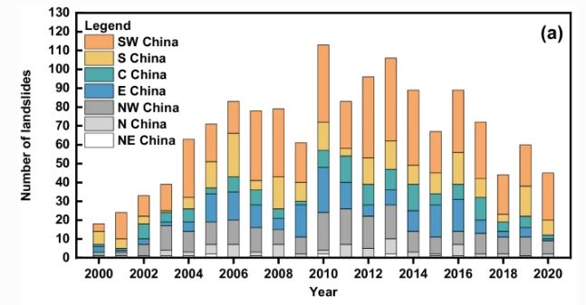
The annual total number of fatal landslides in China, broken down by geographical region. from Zhang et al. (2023).
.
Understanding the cause of this change is extremely important. Zhang et al. (2023) have looked at this in some detail. One element is potentially explained in the graph below, from the paper, which shows the number of fatal anthropogenic landslides with time:-
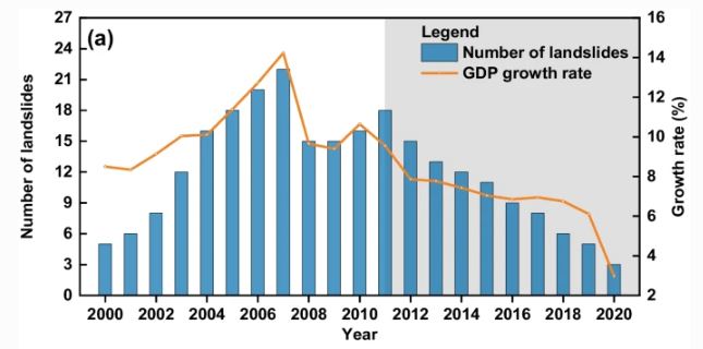
The annual pattern of anthropogenic landslides and the growth of GDP with time in China. Graph from Zhang et al. (2023).
.
Here the peak is a little earlier (around 2007), and again the declining trend in the latter years is very clear. So, it appears that at least a part of the trend observed in China is due to a reduction in the number of anthropogenic landslides. But this is when it gets really interesting. The orange line on the graph is the growth in GDP for China. The similarity in trend between the number of fatal landslides and the GDP is remarkable (Zhang et al. 2023 have calculated the correlation coefficient to be 0.832). They explain this as follows:-
The years of rapid GDP growth were usually accompanied by a large number of human activities. These activities modified natural slopes through construction, mining, and quarries, among others, which greatly increased the risks of landslides.
So, it appears that in years of very rapid GDP growth, poorly controlled activities on slopes led to an increased number of fatal landslides. As GDP growth has slowed, the number of fatal anthropogenic landslides has also reduced.
I’m amazed by the strength of the correlation – it appears that GDP growth rate in effect switches fatal landslides on and off.
The authors are absolutely right to present the analysis, and their explanation, and this is an excellent piece of work. I’m left wondering though whether this relationship is real or one of those strange statistical artefacts that sometimes emerge. Can the cause and effect really be as strong as this? And does this apply elsewhere?
It’s a fascinating result that deserves further attention.
.
References
Froude, M. J. and Petley, D. N. 2018. Global fatal landslide occurrence from 2004 to 2016. Natural Hazards and Earth System Sciences, 18, 2161-2181, https://doi.org/10.5194/nhess-18-2161-2018.
Zhang, S., Li, C., Peng, J. et al. 2023. Fatal landslides in China from 1940 to 2020: occurrences and vulnerabilities. Landslides (2023). https://doi.org/10.1007/s10346-023-02034-6
 Dave Petley is the Vice-Chancellor of the University of Hull in the United Kingdom. His blog provides commentary and analysis of landslide events occurring worldwide, including the landslides themselves, latest research, and conferences and meetings.
Recent Comments