
23 February 2023
Vila Sahy, São Paulo: extreme rainfall in Brazil has triggered multiple fatal landslides
Vila Sahy, São Paulo: extreme rainfall in Brazil has triggered multiple fatal landslides
On 19 February 2023, heavy rainfall impacted São Paulo state in Brazil, triggering landslides and floods. At least 48 people have been killed with a further 38 people reported to be missing. The rainfall was centred on the São Sebastiao, in which 47 fatalities have been reported. The Brazil news agency G1 has a very good drone video of the impact of the landslides in Vila Sahy, collected by Andre Bastos – it is well worth a watch. G1 reports that 34 of the victims died at Vila Sahy, which appears to have been the worst affected location. This still is from that video:-
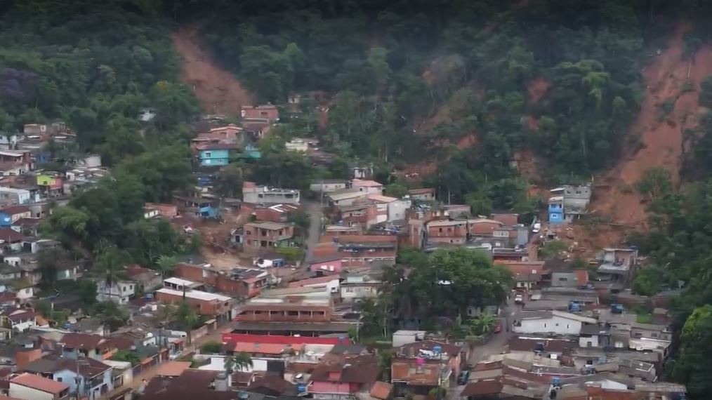
Drone footage of the aftermath of landslides in Vila Sahy in São Sebastião, São Paolo. Still from a drone video collected by Andre Bastos, via G1.
.
Meanwhile, Folha de Da São Paolo has this image (behind a paywall) of the site from a different angle:-
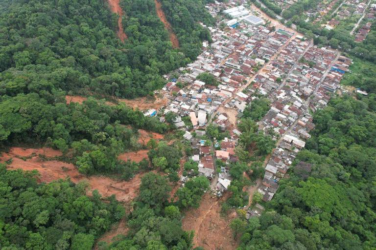
Drone image of the aftermath of landslides in Vila Sahy in São Sebastião, São Paolo. Image from Folha de Da São Paolo.
.
Vila Sahy is located at [-23.766, -45.690]. This is a Google Earth image of the site:-
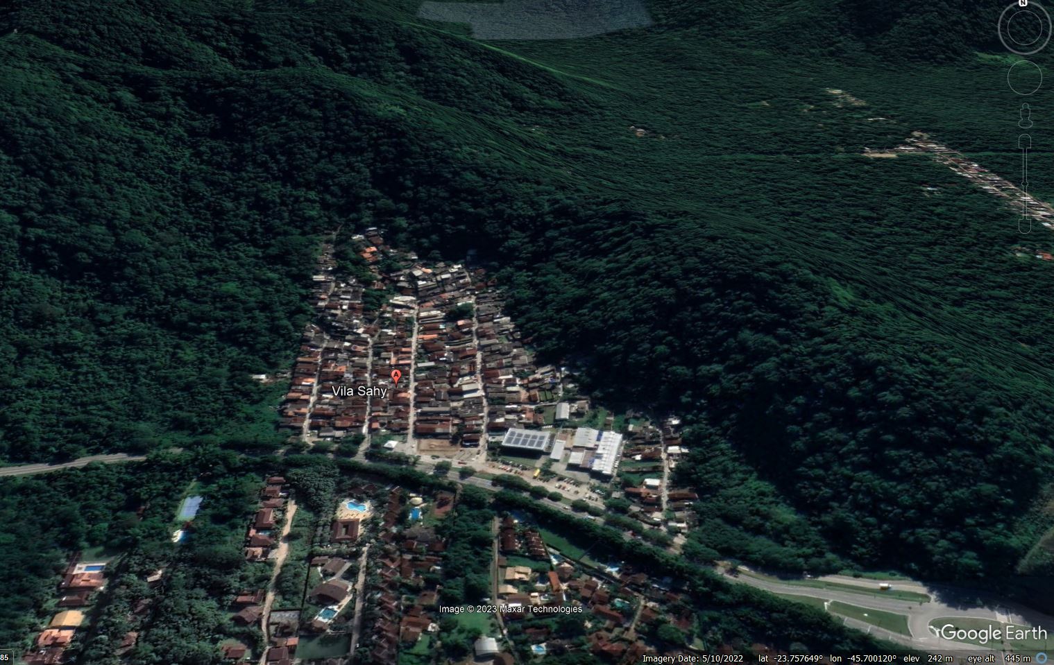
Google Earth image of Vila Sahy in São Sebastião, São Paolo before the recent landslides.
.
The town has built up on an area of level ground that is probably formed primarily from colluvium from previous slope failures from the adjacent slopes. The houses push right up to the foot of the slopes, which (judging by the images above) appear to be formed from deeply weathered (residual) soils. Instability on these slopes is likely in exceptional rainfall events, so tragically these houses were extremely exposed to the hazard.
On Twitter, Raphael Rocha (@raphaeldeque), a Brazilian meteorologist, has an excellent thread highlighting the impacts of the rainfall:-
First assessment of @DisastersChart activation #803 on recent floods and landslides in Brazil. Events triggered by heavy rains above 600 mm in 24h on northern São Paulo coast.
46 fatalities, 49 missing, and 2500 displaced. Updates expected. pic.twitter.com/P1AMkGGfjG
— Raphael Rocha (@raphaeldeque) February 22, 2023
.
Raphael highlights that 600 mm of rainfall fell in just 12 hours, including peak rainfall intensities of 140 mmm per hours. This is an astonishing amount of rainfall.
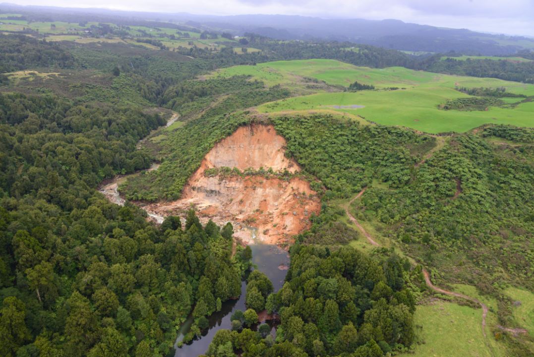
Heavy rainfall is continuing to occur in Brazil at the time of writing, and there are warnings of further landslides. On 22 February 2023, a landslide was triggered in Rio Natal in São Bento do Sul, Santa Catarina, derailing a train. G1 has images of the aftermath:-
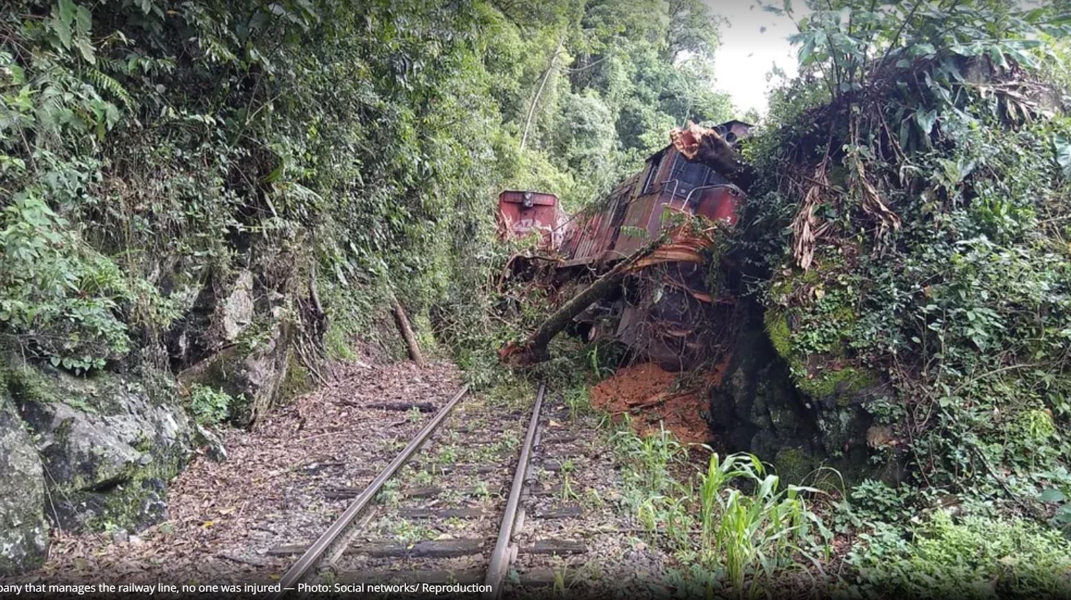
The aftermath of a landslide that derailed a train in in Rio Natal, in São Bento do Sul , in the north of Santa Catarina, Brazil. Image from G1.
.
This recent set of events is causing a great deal of reflection about landslide risk in Brazil. Jornal Extra reports that there are 13,542 sites known to be at risk of landslides, flooding, runoff and erosion. About 4 million people are believed to live in these areas. As short duration rainfall intensities and totals continue to rise, driven at least in part by global heating, it is inevitable that I will be writing about tragedies such as these in Brazil in the future.
21 February 2023
Manutuke: a near miss landslide from Cyclone Gabrielle in New Zealand
Manutuke: a near miss landslide from Cyclone Gabrielle in New Zealand
News of the landslides triggered by Cyclone Garbrielle in New Zealand continues to emerge, assisted by cloud-free conditions that are permitting satellite imagery to be collected. The NZ Herald has an interesting story about a large landslide in Manutuke, situated in the Gisborne District of North Island. The landslide is thought to be the largest failure triggered in the region – and it is an impressive event. The article includes this image:-
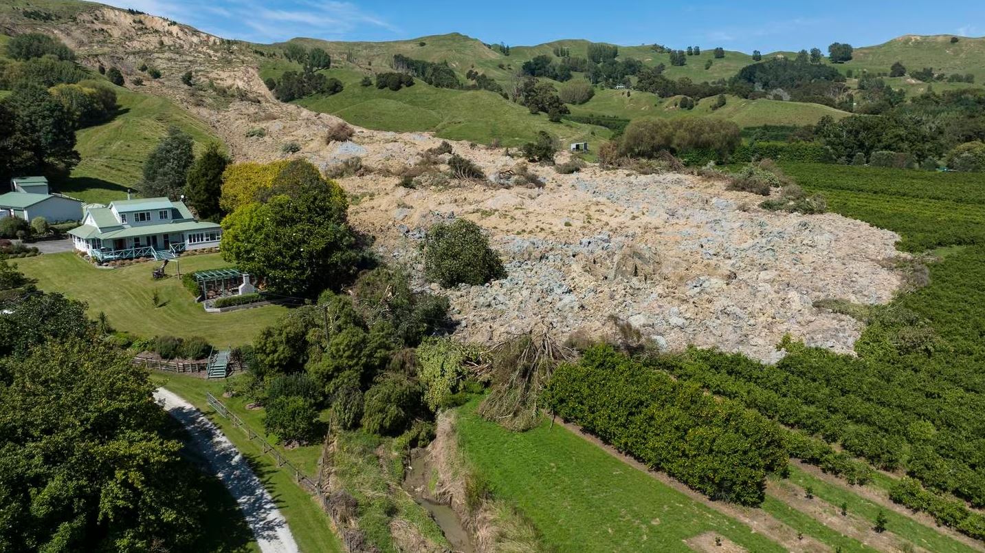
The large landslide at Manutuke in New Zealand, triggered by Cyclone Gabrielle. Image by George Heard / NZ Herald.
.
As the image shows, the landslide missed the house by a small margin. The NZ Herald article provides some detail:
Clive, 69, and Helen, 58, Foster have been living back at their property on Taurau Valley Rd for a few days since the massive rocky slip filled in a 20 metre deep valley beside their property just after 6pm on Tuesday.
“It’s pretty amazing, aye? It’s huge. Our boundary is just down here… Basically 99 per cent of it missed us, you know what I mean,” Clive Foster said of the downhill effects of Cyclone Gabrielle.
“We just said ****, we’re both alive, no one got injured, the house is all functioning like it was last week, it’s all fine. Really speaking, it’s great. What the hell? We’re alive. It’s just a mess.”
The rate of movement was slow, according to the article, in keeping with the earthflow typology of the landslide. The house has been red stickered – i.e. it cannot now be occupied, presumably because of uncertainty about the likelihood of a further failure.
The landslide at Manutuke can be seen on Planet imagery:-
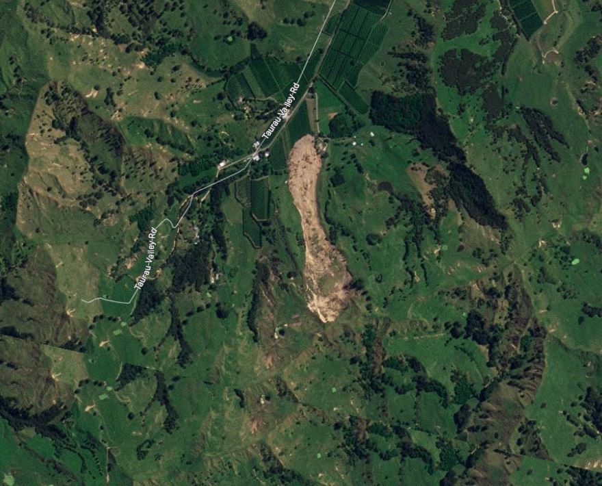
Satellite image showing the landslide at Manutuke. Image copyright Planet, used with permission. Image dated 19 February 2023.
.
The crown of the landslide is in the south, so the house is in the north-east extent of the landslide. The landslide is almost exactly 1 km long. The location of the landslide is [-38.730, 177.878].
This is just one of many thousands of landslides triggered by the cyclone. On Twitter, this helicopter image has been posted showing landslides in the Wairoa region:-
https://twitter.com/Infideliter2022/status/1627501994331230214
.
Whilst the image is unverified (and the claim of dozens of bodies is also not being reported elsewhere), it appears to show hundreds of shallow landslides. Imagery from Planet in the Wairoa area suggests that this is indeed the case:-
Satellite imagery showing landslides in the Wairoa area, triggered by recent rainfall. Image copyright Planet, used with permission. Image dated 20 February 2023.
.
The level of landslide events is similar to that caused by the infamous Cyclone Bola in 1988, which also triggered large numbers of shallow failures.
.
Reference and acknowledgement
Planet Team (2023). Planet Application Program Interface: In Space for Life on Earth. San Francisco, CA. https://www.planet.com/
20 February 2023
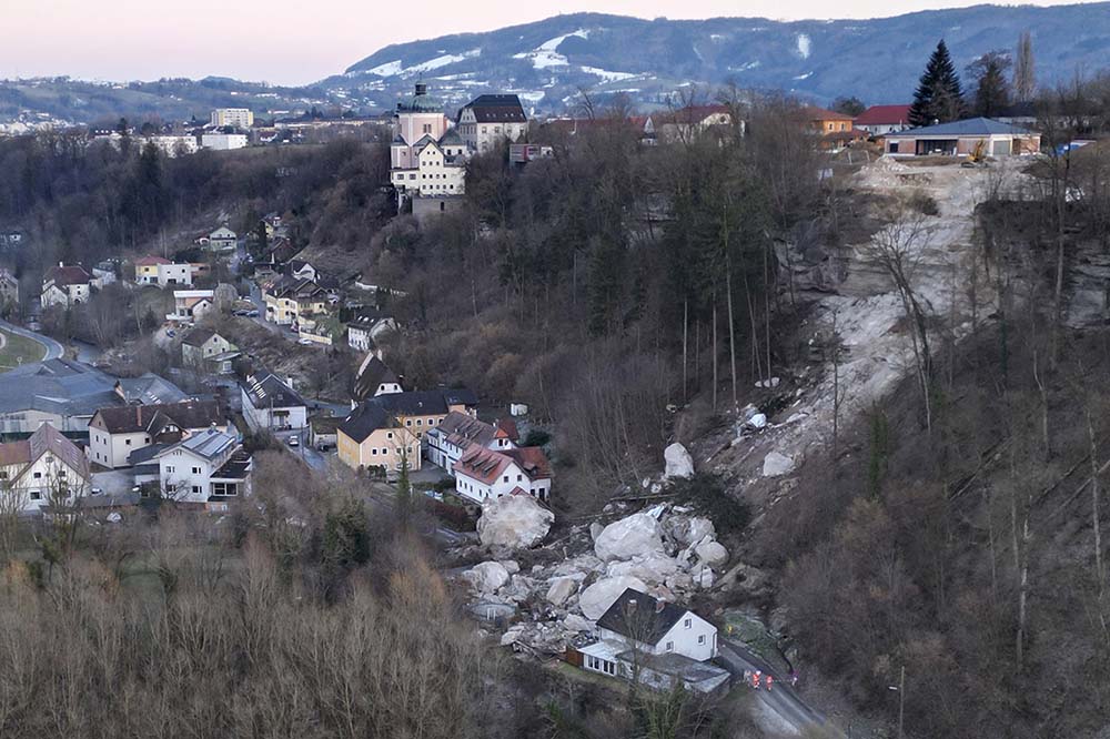
The 8 February 2023 rockfall in Steyr, Austria
The 8 February 2023 rockfall in Steyr, Austria
On Wednesday 8 February 2023 a large rockfall occurred at Christkindl in the town of Steyr in Austria, killing two men, both operators of excavators working at the site. Steyr News has a gallery of images of the aftermath of the tragic accident:-
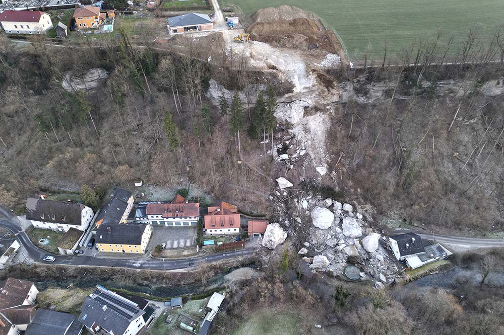
The aftermath of the rockfall at Steyr in Austria. Image by Peter Kainrath by Steyr News.
.
The same source has a view from another angle:-
The aftermath of the 8 February 2023 rockfall at Steyr in Austria. Image by Peter Kainrath by Steyr News.
.
News reports suggest that the slope at Steyr was identified as being potentially unstable a year ago, and that the operations at the site were intended to mitigate the hazard. The houses at the foot of the slope had been evacuated during the works. In fact, the boulders appear to have missed the main part of the houses, although some smaller structures have been destroyed. Tragically, it took almost a week to recover the bodies of the two victims due to the complexities of the site. Moving boulders on this scale is extremely difficult.
The location of the accident appears to be 48.039, 14.385. News reports indicate that the rockfall was about 3,000 cubic metres in total.
Meanwhile, in New Zealand the true extent of the devastation wrought by Cyclone Gabrielle is becoming ever more clear. Stuff has a gallery of images of the destruction in just one area, the Esk Valley. It is worth a look. The BBC reports that the rebuild cost is likely to be similar to that of the Christchurch Earthquake sequence. New Zealand only has 122,000 people with a taxable income of greater that NZ$150,000 (US$93,600), so this is an enormous burden to carry, on top of the costs of the Christchurch and Kaikoura earthquakes, and other recent climate related disasters.
16 February 2023
Muriwai: the complex story of a fatal landslide in New Zealand
Muriwai: the complex story of a fatal landslide in New Zealand
In New Zealand, the clean up after the heavy rainfall of recent weeks, and in particular the impacts of Cyclone Gabrielle, continues. The number of landslides is very high – Auckland Council estimates that there have been 3,000 to 5,000 landslides in that region alone, with about 1,000 causing damage to properties and infrastructure. The ground remains saturated, and some rain has continued to fall, so the risk of slope failures continues.
Landslides killed at least two people. In one event, at Muriwai, a slope failure killed a volunteer member of the fire and rescue service, Dave van Zwanenberg, and left another critically injured. The NZ Herald has an excellent article about this landslide, and others in the Auckland area. It quotes an old friend of mine, Tim Davies of the University of Canterbury, who has noted that the recent events will probably have changed the landslide risk profile of Auckland permanently:
“…the slips this week might have destabilised adjacent areas and made them more likely to fail in future storms.”
I think this is likely to be correct.
Meanwhile, the Muriwai landslide event is also explored in an article on Stuff. Martin Brook of the School of Environment, University of Auckland has noted that the track of the landslide partially coincides with another landslide that occurred in 1965, killing two people. Back in 2013, the same outlet ran a story about this earlier landslide. Rather presciently, the 2013 article quotes Kay Allen, a resident of Muriwai at the time of the 1965 landslide, on seeing a small slip in the same area:
“The Mt Somers resident was horrified to see yet another landslide above Domain Cres in Muriwai.
“I don’t want to see history repeating itself,” Ms Allen says … “We walked down to the slip to have a look – it’s nowhere near as big but it’s in the same place and the ground looks unstable.”
The Waitemata County Council declared back then that the sections in the path of the slip would never be built on.
“There are now houses on all those sections,” Ms Allen says, decades later.
Newstalk has a gallery of photographs of the aftermath of the landslides at Muriwai, which includes this aerial image of the site of the fatal failure:-
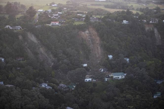
The aftermath of the landslides at Muriwai. Image by George Heard via Newstalk.
.
Meanwhile, Stuff has another gallery of images from this area, which illustrates the scale of the problems. Recovery is going to be a slow and expensive process.
14 February 2023
Landslides in North Island of New Zealand from Cyclone Gabrielle
Landslides in North Island of New Zealand from Cyclone Gabrielle
As forecast, Cyclone Gabrielle has struck New Zealand, bringing very high rainfall totals to North Island. This comes on top of the recent heavy rainfall events in the area, which have already triggered many landslides. The Prime Minister has declared a National State of Emergency for only the third time, but the true picture remains a little unclear as areas are cut off with limited communications.
The northern part of New Zealand is having an extraordinary start to the year – remember, this is summer there. Met Service tweeted this graph of cumulative rainfall for Auckland Airport, including data for the years since 2019 and the long term average:
To help put 2023 in context for Aucklanders, here is the Airport rain accumulation plot (red line is 2023, showing a total of 540mm).
The Airport has seen about half (48%) of its annual rainfall in just 45 days. Drier weather for the coming days, https://t.co/tks2Q488UD ^GG pic.twitter.com/vyA1UOmNE7
— MetService (@MetService) February 14, 2023
.
News of landslides is starting to appear – we can expect that there will have been many, many slips once again. There is information about a tragic landslide in Muriwai in Auckland, which has left one firefighter critically injured and another missing. As I write the search is ongoing, but the situation seems to be grim. It appears that there have been at least two landslides in Muriwai – this image shows the aftermath of another event:-
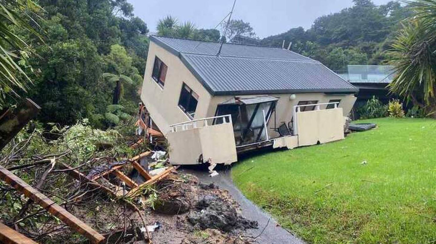
The aftermath of a landslide in Muriwai, Auckland following Cyclone Gabrielle. Image from NZ Herald.
.
Meanwhile, another significant landslide has occurred in Karekare. There are reports that five houses have been destroyed, whilst Newsroom has this image of the aftermath:-
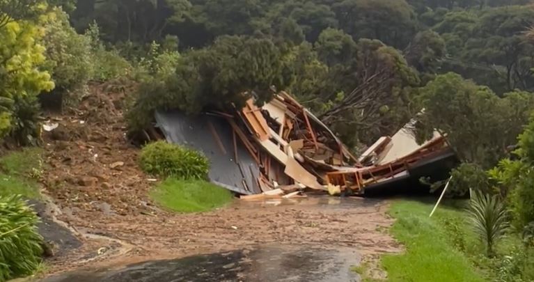
The aftermath of a landslide in Karekare in New Zealand, which destroyed five houses. Image from Newsroom.
.
In the rural areas, it is likely that there will have been some damaging landslides. NZ Herald has tweeted this image of a large failure on the Awhitu Peninsula:-
A huge slip has emerged on the Awhitu Peninsula! pic.twitter.com/iK9DuSQu1b
— nzherald (@nzherald) February 14, 2023
.
It is interesting that the crown of the landslide is at the road. Stuff also has a report of a landslide that partially buried a truck on the Matatā straights in the Bay of Plenty:-
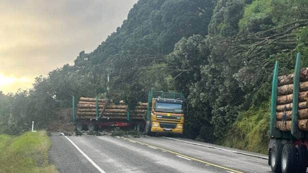
The aftermath of a landslide in the Bay of Plenty in New Zealand, triggered by Cyclone Gabrielle. Image posted by Stuff.
.
Stuff has a gallery of images of the aftermath of the storm, many of which show landslides.
Cyclone Gabrielle is now moving away from New Zealand, so the situation should start to improve overnight, but the damage is clearly very extensive.
13 February 2023
Emerging information about landslides from the 6 February 2023 Turkey–Syria earthquakes
Emerging information about landslide from the 6 February 2023 Turkey–Syria earthquakes
The loss of life from the dreadful 6 February 2023 Turkey–Syria earthquakes has now reached a horrifying 33,000 people, with further increases possible. Media interest is starting to wane as the rescue operation winds down. It is worth noting that whilst a small number of remarkable rescues continue to occur, providing for the millions displaced and the thousands who have been injured is likely to be the biggest challenge, and needs to be the focus of attention. This will last for years, long after the cameras have disappeared. The plight of those left in refugee camps is often very poor, especially for women and girls.
In tis context, writing about landslides feels trivial, but of course in their own right they cause major challenges. Amongst the many tweets about the fault are some that show landslides and other types of ground failure. For example, @Sabah has tweeted a remarkable video of the aftermath of a catastrophic lateral spread in a road embankment:-
YOL YERLE BİR OLDU
Adıyaman-Şanlıurfa-Gaziantep Otoyolu'nun üzerinden geçen Köşeli köyünün yolunun yerle bir olması ve oluşan devasa çatlaklar depremin büyüklüğünü bir kez daha gösterdi. pic.twitter.com/BLu2ADfTLE
— Sabah (@sabah) February 12, 2023
.
The translation states that:-
“The collapse of the road to the village of Koseli, which passes over the Adıyaman-Sanliurfa-Gaziantep Highway, and the huge cracks that formed once again showed the magnitude of the earthquake.”
This is a still from the video:-
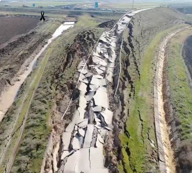
An extraordinary lateral spread in an embankment, triggered by the 2023 Turkey-Syria earthquakes. Image from a video posted to Twitter by @Sabah.
.
This would make an interesting case study for further analysis. I find it interesting that the highest part of the embankment, in the distance in the image, did not fail, and that there are signs of deformation in the ground beyond the ditch on the left side of the image. I am not an expert in lateral spreads, but I wonder if this involved failure in the ground below the embankment? The failure is quite reminiscent of the event triggered by the 30 November 2018 Alaska earthquake.
Meanwhile, another very large failure has attracted considerable attention. On social media there has been some confusion between a landslide and the fault scarp over this event, but Dr Judith Hubbard at Cornell has provided clarity:-
This rift is not a fault, but was still caused by Monday's earthquakes. It is the headscarp of a landslide.
Landslides and rock falls are common triggered hazards in earthquakes.
— Dr. Judith Hubbard (@JudithGeology) February 11, 2023
.
It is worth reading the full thread – I agree with her analysis that this is a large slope failure. She has tracked down the location to 36.159, 36.223.
Finally (for now?), Nahel Belgherze has identified another large slope failure from satellite imagery:-
https://twitter.com/WxNB_/status/1624470130510991361
.
The location is 37.003, 36.592. Note the damage to the road at the foot of the slope.
I suspect that more landslides will become evident in the coming days, but clearly (and rightly) this has not been the priority so date.
10 February 2023
GeoNet information about recent landslides in New Zealand
Geonet information about recent landslides in New Zealand
The recent prolonged heavy rainfall in the northern part of New Zealand triggered large numbers of landslides, some of which caused extensive damage. GeoNet is New Zealand’s wonderful natural hazards monitoring and response organisation. Working under the GeoNet banner, the landslide team at GNS Science has been collecting information about the landslides triggered by the rainfall. They have posted some details of their investigations on the GeoNet site – it is worth a look.
In terms of Auckland, the team reports that:
“They found small shallow landslides to be common across most of the hills, with the occasional larger more impactful landslide. Rockfalls and landslides were frequent across the coastal cliffs of Auckland, with numerous buildings affected. Inland there are multiple buildings impacted by landslides.”
They have provided images of some of the landslides, including this one:-
A landslide in the Auckland area of New Zealand, triggered by the recent heavy rainfall. Image by the GNS Science landslide team, via GeoNet.
.
This is a fascinating landslide in its own right, with multiple source zones. The debris has coalesced into a channelised flow with a long runout. Note that the main channel is blocked and a small lake has formed. The timber on the site appears to have been felled comparatively recently.
There is a brilliant 3D model of this landslide – a fantastic teaching resource.
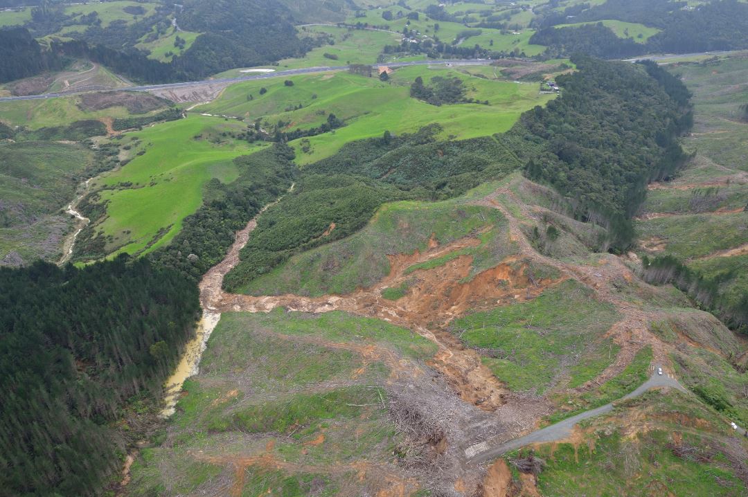
In the Waikato and Bay of Plenty area, the GeoNet / GNS Science team has recorded c.160 landslides. They describe them thus:
“Many of the landslides around Tauranga Harbour occurred on steep coastal slopes composed of sedimentary deposits. Inland, most of the landslides were associated with road cuts, steep river valleys, forestry clearance, and weathered volcanic rock. Around the Coromandel Peninsula, the spatial occurrence of landslide activity was highly variable, but mostly concentrated in areas with sedimentary rocks, especially where forest cover was absent or where slopes had been steepened by roading or coastal erosion . In both Tauranga and Coromandel Peninsula, a small number of landslides occurred within native forest cover, associated with particularly steep slopes. Several slopes only partially failed, with large cracks visible above the landslide scars, or with partly displaced debris visible on the slopes. These ‘incipient’ landslides are likely to become sites of further slippage, especially in subsequent rainfall events.”
Again, there are some great images, including this one:
A landslide that blocked the Kaukaumoutiti Stream, northwest of Tauranga in New Zealand, triggered by the recent heavy rainfall. Image by the GNS Science landslide team, via GeoNet.
.
Once again this is a valley-blocking event. The failure appears to be rotational (note the partially displaced block). The underlying cause may have been undercutting the river – the location is on the outside of the bend, where erosion is highest. There is a beautiful 3D model of this landslide too, which even captures the flow of water over the dam.
Incredibly, the area is about to be struck by another extreme event, Cyclone Gabrielle. This is likely to bring another period of exceptional rainfall:-
https://twitter.com/MetService/status/1623805989152759809
.
It seems likely that the GNS landslide team will have another busy few days.
8 February 2023
Secocha: reports of 40 fatalities in landslides in Peru
Secocha: reports of 40 fatalities in landslides in Peru
On Sunday 5 February 2023 a series of deadly landslides struck the town of Secocha in Mariano Nicolás Valcárcel district, which is in Arequipa, Peru. Reports indicate that a further 20 people have been injured and that over 600 houses have been destroyed.
There are some dramatic landslides of the mudflows and debris flows that have been responsible for the destruction. The Guardian has a video that provides a montage of some of the footage, posted to Youtube:-
.
There are some other dramatic videos too, such as this one posted to Twitter that shows a very high energy flow:-
La consecuencia de seguir permitiendo ocupaciones en zonas inadecuadas y altamente propensas a deslizamientos #Secocha #Arequipa @udealima @limacomovamos @UrbesLab @CIESLimaPeru @IEPeruanos https://t.co/C4vMWclalh pic.twitter.com/5DyAn1Zw8m
— Fernando (@_FernandoNeyra) February 6, 2023
.
And this one, that shows a pulse of debris bulldozing through the town:-
https://twitter.com/LoveWorld_Peopl/status/1623045650613936143
.
Meanwhile, Infobae has this image of the front of a debris flow passing through a community:-
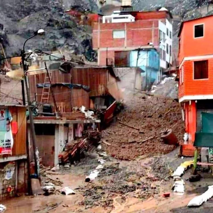
One of the debris flows passing through a community in Secocha, Peru. Image via Infobae.
.
At the moment the background to these events is a little unclear, as is the human cost Al Jazeira reports that the landslides were triggered by heavy rainfall, which is consistent with the images and videos. However, it also reports that 36 people were killed “in an isolated area called Miski”. Meanwhile, the Peruvian agency RPP News has also reported that some of the dead had been struck by falling rocks as they travelled by truck along the Urasqui-Secocha highway. I am assuming that these various reported deaths are included in the headline figure of 40 people, but this remains to be confirmed.
Secocha is located at -15.982, -73.172. This is a Google Earth image of the site:-
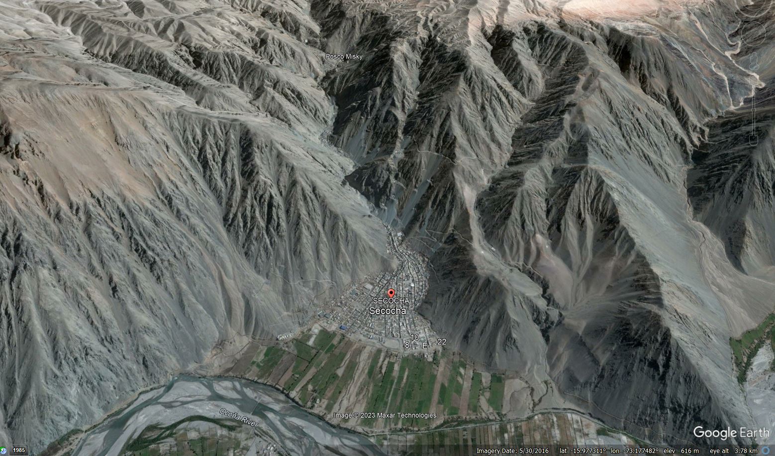
Google Earth image of Secocha in Peru.
.
The vulnerability of the town to landslides is very clear – the community is built on an active fan, with houses directly in the flood channel There are landslides scars and large amounts of debris on the slopes upstream.
The image also shows Posco Misky, presumably “Miski” referenced above, which is located at -15.989, -73.190. The hazard here is even greater. This is a Google Earth image of the village:-
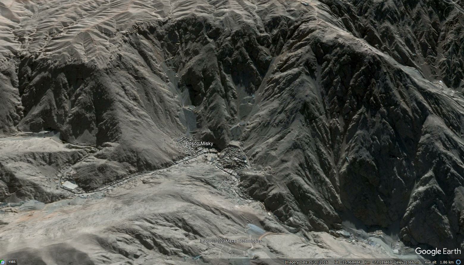
Google Earth image of Posco Misky in Peru.
.
Posco Misky is a site of artisanal gold mining. The location has all of the hazards present at Secocha, but also a large amount of (presumably) mining waste stored on the slopes above the town, as the image above shows. This is a horrifyingly dangerous location.
Interestingly, Andina reports that Ingemmet (the Geological, Mining and Metallurgical Institute) recommended in both 2014 and 2021 that the population of Secocha should be relocated due to the level of hazard at the site. The 2021 report is available online (in Spanish).
7 February 2023
First images of landslides from the 6 February 2023 Turkey-Syria earthquakes
First images of landslides from the 6 February 2023 Turkey-Syria earthquakes
The true horror of the major Turkey-Syria earthquakes yesterday is beginning to unfold. With over 4,300 people now known to have died, but many more likely to be missing, this has been a very serious event. Most of the footage continues to feature collapses in the urban areas, with very little from the more rural areas. The picture in the more remote parts of the epicentral zone is likely to be desperate.
Meanwhile. as expected, images are starting to emerge of landslides triggered by the event. In common with other events, at the moment these focus on the roads, probably because the slides themselves are a barrier to reaching the upland zones.
On Twitter, Sokagin Sesi Gazetesi has tweeted a short video of a large failure on a riverbank; the text suggests that this is on the road between Adana and Gaziantep:-
DEPREM SONRASI ADANA GAZİANTEP YOLU! pic.twitter.com/7T05gVOHt0
— Sokağınsesi Gazetesi (@sokaginsesigaz1) February 6, 2023
.
The image below is a still from the video:-
The lateral flow landslide on the road between Adana and Gaziantep following the 6 February 2023 Turkey-Syria earthquakes. Image from a video tweeted by Sokagin Sesi Gazetesi.
.
This appears to be a lateral spread failure on a very large scale. The road bed could be fill?
Meanwhile, Erk Acarer has tweeted an image of another large failure on a road:-
Yol yaptı… pic.twitter.com/i9JbVbBEaH
— Erk Acarer (@eacarer) February 6, 2023
.
The location of this failure is not clear, but once again this could well be a lateral spread.
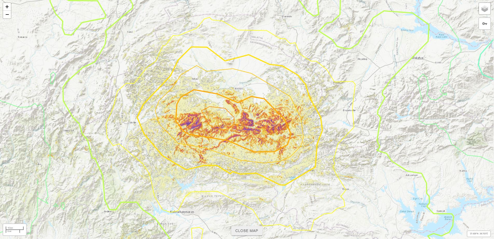
Meanwhile, the USGS has continued to update its model of the landslide probability for the Turkey-Syria earthquakes. This is the map for the Mw=7.8 event:-
.
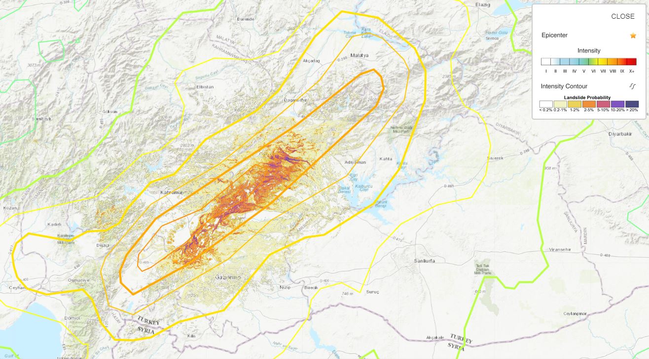
And this is the one for the Mw=7.5 event that occurred a few hours later:-
.
Unfortunately, the epicentral area was cloudy yesterday, so there is no visible satellite imagery as yet of the earthquake-affected areas. The forecast today is better, and tomorrow is good, so images should start to become available. Note though that the forecast night time temperature in Gaziantep is -6° C tonight, and will be lower in the upland areas. These temperatures are likely to be magnifying the human the impact of the Turkey-Syria earthquakes.
6 February 2023
Potential landslides from the 6 February 2023 Mw=7.8 earthquake near Nurdağı in Gaziantep, Turkey
Potential landslides from the 6 February 2023 Mw=7.8 earthquake near Nurdağı in Gaziantep, Turkey
Initial reports from the area affected by the Mw=7.8 earthquake near Nurdağı in Gaziantep, Turkey in the early hours of 6 February 2023 indicate that this will be a very serious event. Some parts of the media are chasing the reported number of fatalities in Turkey and Syria, whereas it is likely that the number of deaths will be in the high hundreds at least, and probably in the thousands. In the aftermath of the Haiti earthquake in 2010 I wrote about disaster reporting – these points will apply here.
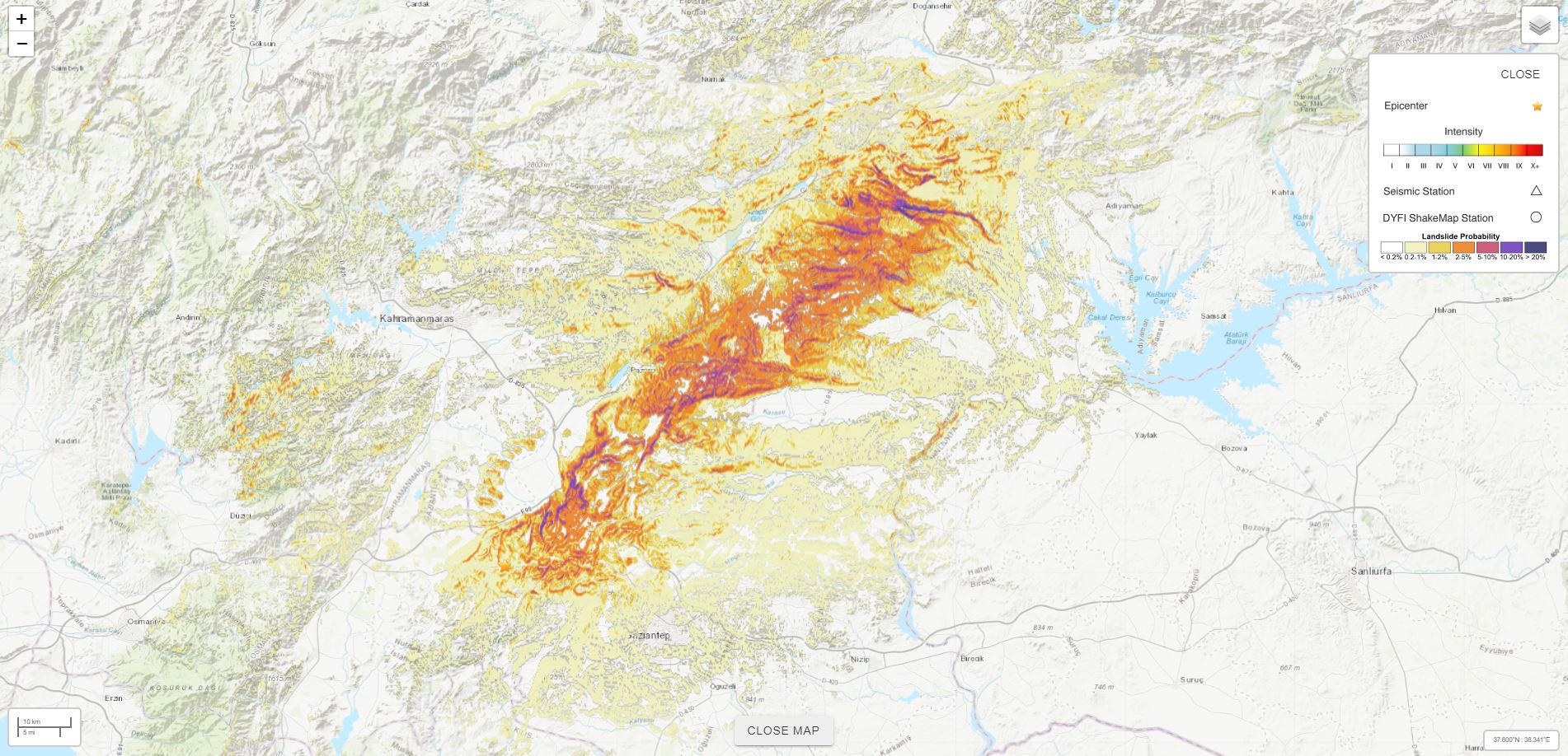
Landslides are likely to have been a significant problem in this event. The best available information comes from the USGS ground failure model, although this is very provisional at this stage. The earthquake itself had a strike slip mechanism, with the fault orientated NE-SW. The provisional USGS landslide probability map looks like this:-
.
It is important to emphasise that this is provisional. The map will improve as better data becomes available about the fault and the mechanisms of the earthquake. But the above model has allowed the USGS to make an initial estimation of the area affected by landslides and of the population that has been exposed to the hazard:-
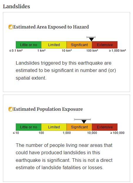
.
Based upon this we are likely to see some landslide fatalities plus substantial numbers of roads blocked by failures. This will impede the rescue work, especially in the initial, all-important, 24 hour period, in more remote areas. In general, landslides from strike-slip earthquakes cluster close to the surface expression of the fault trace, although some can still occur at considerable distances.
At the time of writing there are few images from the area affected by the earthquake, mostly showing collapsed buildings. However, Daily Sabah has an interesting image showing Gaziantep Castle, which appears to have at least partially collapsed:-
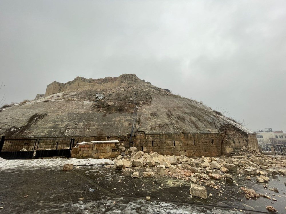
The collapse of Gaziantep Castle as a result of the 6 February 2023 earthquake near to Nurdağı in Turkey. Image from the DHA Photo via the Daily Sabah.
.
Note the retaining wall failure at the foot of the slope.
 Dave Petley is the Vice-Chancellor of the University of Hull in the United Kingdom. His blog provides commentary and analysis of landslide events occurring worldwide, including the landslides themselves, latest research, and conferences and meetings.
Recent Comments