
28 February 2023
Joshimath: new satellite imagery and ongoing issues with the movement of the landslide
Posted by Dave Petley
Joshimath: new satellite imagery and ongoing issues with the movement of the landslide
The current phase of the Joshimath landslide crisis in India is now almost two months old, with little sign of a permanent solution to the problem. This remains a case study in poor hazard communication – for example, the panel set up to investigate the hazard has still to release a report, although it does appear to have been submitted to the Prime Minister’s Office. The Economic Times reports that “[t]he committee has flagged concerns about potential problems in the adjoining areas and directed the state authorities to take immediate steps, according to officials”, whatever that means. Meanwhile, another group of experts visited the site yesterday, but I am unsure as to how this relates to the original panel.
Demolition of two large hotels at Joshimath, Mount View and Malari Inn, has now been completed. Planet has managed to capture a high resolution satellite image of the Joshimath landslide – this is shown below, draped onto the Google Earth DEM,with the Hotel Mount View marked:-
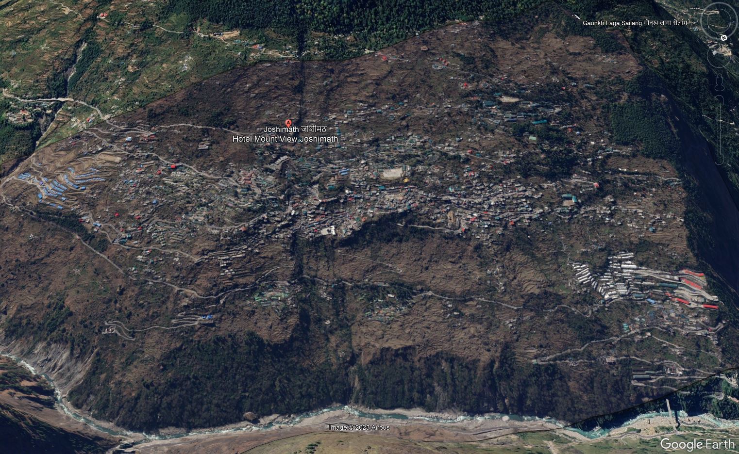
High resolution image of the Joshimath landslide draped onto the Google Earth DEM. Image copyright Planet, captured 27 February 2023, used with permission.
.
Below is the image in more conventional format, for reference:-
High resolution image of the Joshimath landslide. Image copyright Planet, captured 27 February 2023, used with permission.
.
Al Jazeera has a very good article about the wider implications of the rapid pace of poorly controlled development in the Indian Himalayas, which includes some beautifully framed images of the damage to Joshimath. It includes a description of the village of Haat, which was located at [30.426, 79.419]. This is a Google Earth image of the site of the village, collected on 9 November 2022:-
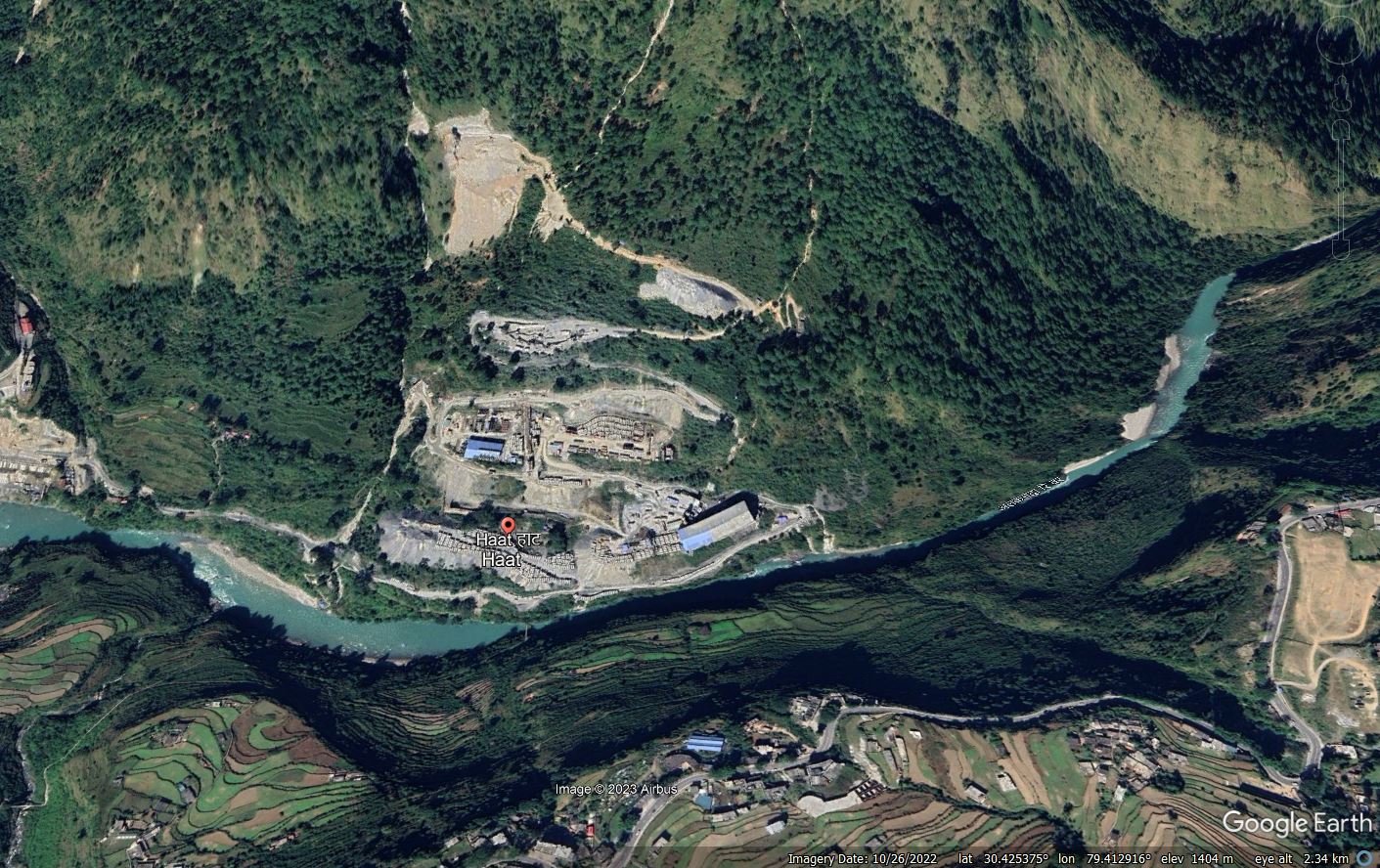
Google Earth image of the site of the village of Haat in northern India.
.
The Al Jazeera article makes this point about Haat:-
Haat, along the Alaknanda River, was once a sacred hamlet where Adi Shankaracharya is said to have established another temple in the eighth century.
Today, it is a dumping site for waste and a storage pit for construction materials after the village was acquired in 2009 by an energy enterprise to build a hydropower project.
The Laxmi Narayan temple is the only part of the village still standing. All of its residents were relocated, said Rajendra Hatwal, once the village chief who now lives in another town.
Hatwal and a few others still check in on the temple. A caretaker, who refused to leave, lives in a makeshift room next to it. He sweeps the ground, cleans the idols and prepares tea for the odd guest who comes through.
The point is well made – the image clearly shows waste being stored in large volumes on the slope in at least three locations. This looks to be somewhat hazardous.
Meanwhile, slope deformation is being noted in other locations in the Indian mountains, such as Doda in Jammu and Noklak in Eastern Nagaland.
.
Reference and acknowledgement
Thanks as ever to my friends at Planet for providing fabulous imagery again.
Planet Team (2023). Planet Application Program Interface: In Space for Life on Earth. San Francisco, CA. https://www.planet.com/
 Dave Petley is the Vice-Chancellor of the University of Hull in the United Kingdom. His blog provides commentary and analysis of landslide events occurring worldwide, including the landslides themselves, latest research, and conferences and meetings.