
7 March 2023
The remarkable landslide in an olive grove near to Hatay, triggered by the Turkey earthquakes
Posted by Dave Petley
The remarkable landslide in an olive grove near to Hatay, triggered by the Turkey-Syria earthquakes
Yesterday marked one month since the 6 February 2023 Turkey-Syria earthquakes, which have had such a devastating impact across a wide area of both countries. Investigations of the coseismic landslides continue – I recommend the Twitter account of the SLATE-landSLide Assessment TEam (@SLATE_landslide), a group of Turkish landslide specialists who are providing updates on their work investigating the major failures.
One landslide that has attracted some interest is the large failure in an olive grove near to Tepehan, which some people have termed the Hatay landslide. The location of the failure is [36.161, 36.222]. My friends at Planet have very kindly captured before and after satellite imagery of the failure using the high resolution SkySat instrument. This is the site before the landslide:-
Satellite image of the site of the landslide in an olive grove near to Tepehan in Hatay, Turkey. Image copyright Planet, used with permission, collected on 21 November 2021.
.
Whilst this is the same site after the earthquake:-
Satellite image of the landslide in an olive grove near to Tepehan in Hatay, Turkey. Image copyright Planet, used with permission, collected on 22 February 2023.
.
I have created a slider that should allow you to compare the before and after images:-
.
In the media there has been some confused reporting about this landslide, with some mistaking the landform for the fault rupture. This is a block slide type of failure, probably on a weak layer in a dip slope, which has allowed parts of the olive grove to remain intact despite large displacements. This block diagram from the USGS explains the concept well:-
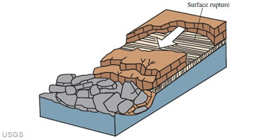
USGS conceptual diagram of a block slide landslide.
.
Robin Lacassin has a good tweet that highlights the main features of the landslide close to Hatay:-
https://twitter.com/RLacassin/status/1630186366628765696
.
There is quite a nice video on Youtube showing the aftermath of the landslide:-
.
I will look forward to reading more about this failure once it has been investigated fully.
.
Acknowledgement and reference
Many thanks once again to the wonderful team at Planet.
Planet Team (2023). Planet Application Program Interface: In Space for Life on Earth. San Francisco, CA. https://www.planet.com/
 Dave Petley is the Vice-Chancellor of the University of Hull in the United Kingdom. His blog provides commentary and analysis of landslide events occurring worldwide, including the landslides themselves, latest research, and conferences and meetings.
Might the laterally extending wooded features above the area of the current landslide have been created during previous landslide events ?
Is it just me or could this be a reactivation of an existing weak plane? The portion of the scarp on the upper part of the slider image seems to be present in both the before and after photos. Would be nice to see LiDAR of the area before the earthquakes.
Any idea what the deep bedrock is? Appears like a massive/uniform weathered tuff. Must find geologic map somewhere.
Remarkable block slide. The substrate is really unusual looking; presumably bedrock (chert? looks to have conchoidal fracture on the large grey blocks) but could it be unlithified lacustrine sediments? Anyone know?
Remarkable block slide. The substrate is really unusual looking; presumably bedrock (chert? looks to have conchoidal fracture on the large grey blocks) but could it be unlithified lacustrine sediments? Anyone know?
The Turkish government’s geology website isn’t responding at the moment, but one publication I found (which frustratingly but typically cuts off about 5 km from this location) suggests these interesting-looking rocks are Miocene marls and claystones. See Tari et al. (2014) The geology and morphology of the Antakya Graben between the Amik Triple Junction and the Cyprus Arc, Geodinamica Acta at https://www.tandfonline.com/doi/full/10.1080/09853111.2013.858962
The currently unavailable 1:100,000 state geological map is the Antakya-Hama sheet.
Earthquake Helpers is a website that let’s you find charities easily.
Have visited the site. The slide occurs in diatomaceous shale interbedded with clay shale. The rupture surface follows bedding. The surrounding terrain is consistent with past landsliding, with weathered scarps extending along and upslope of this earthquake-triggered slide.