
13 March 2023
The NRSC/ISRO Landslide Atlas of India
Posted by Dave Petley
The NRSC/ISRO Landslide Atlas of India
The National Remote Sensing Centre (NRSC) of the Indian Space Research Organisation (ISRO) released last week a Landslide Atlas of India, which is freely available online. It provides maps of about 80,000 landslides that have been identified across India in the period between 1998 and 2022, with a particular emphasis on seasonal landslides triggered by the 2014 and 2017 monsoon seasons, as well as by the Sikkim earthquake.
The Atlas has been compiled using imagery collected from a range of sensors, including the Indian satellites IRS-1D PAN+LISS-III, Resourcesat-1, 2 & 2A LISS-IV Mx, Cartosat-1 and 2S; and international instruments such as Sentinel-1&2, Pleiades and WorldView; and through the use of aerial photographs.
One of the key results is a single map showing all of the identified landslides in India:-
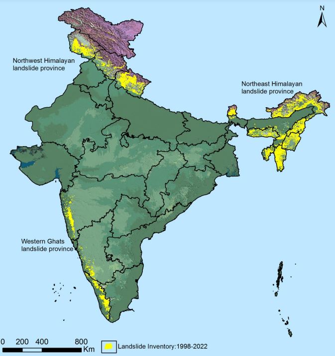
A map showing all of the identified landslides in India. Source: NRSC/ISRO Landslide Atlas of India,
.
This is fascinating map, highlighting the ways in which landslides are geographically concentrated, particularly in the northern (mountainous) areas and along the southwest margin of the country.
The atlas also provides a very interesting assessment of macro-level socioeconomic risk exposure to landslides:-
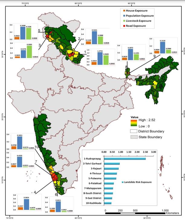
Socioeconomic risk exposure to landslides in India, based on the NRSC/ISRO Landslide Atlas of India.
.
The bar chart then indicates the ten districts with the highest socioeconomic risk exposure to landslides, of which Rudraprayag and Tehri Garhwal in Uttaranchal rank highest. This assessment feels quite experimental to me, but it is interesting. I would be fascinated to hear more details about it as the description in the atlas is quite brief.
This atlas is a really interesting initiative to highlight landslide risk in one of the most impacted countries globally. Intriguingly, the Economic Times has just published a separate article about landslide impacts in Himachal Pradesh, which is one of the high landslide impact states in the north of the country. The analysis has been undertaken by the Himachal Pradesh State Disaster Management Authority (although the report does not appear on their website).
The study has identified 17,120 landslide prone sites across Himachal Pradesh. Of these, 675 have been identified as posing higher levels of risk, and the report indicates an increasing trend with time (although I must caveat that simply comparing two years of data, as the report seems to do, is not indicative of a valid trend). Perhaps most interestingly, the Economic Times reports that:
“High intensity rainfall coupled with cutting of hill slopes or rocks at the foothills are the main reason behind the significant number of landslides, experts say. Extensive cutting of hill slopes for construction and widening of roads, blasting for tunnels, hydro projects and mining are cited as reasons behind the increase in landslides, geological expert Prof Virender Singh Dhar said.”
The point that poor construction and land management practices are the key factors behind the increasing landslide impacts in India is well made.
 Dave Petley is the Vice-Chancellor of the University of Hull in the United Kingdom. His blog provides commentary and analysis of landslide events occurring worldwide, including the landslides themselves, latest research, and conferences and meetings.
Proofing error “alas” or “atlas”?
May be alas