
5 June 2023
Landslides associated with rapid snowmelt in western North America in May 2023
Landslides associated with rapid snowmelt in western North America in May 2023
Guest post by loyal reader Funkenbeachin
The NASA map below shows the difference in air temperature between 15 May 2023 and the 2014-2022 mean for the same date. The map, derived from the Goddard Earth Observing System (GEOS) model, depicts air temperatures at 2 metres above the ground. Dark red areas are where air temperatures reached more than 22°F (12°C) above the recent average:-
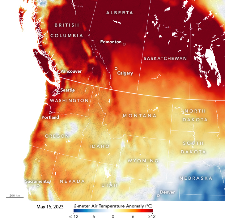
Thermal anomalies for 15 May 2023 compared with the long term average for the same date. Image from NASA GEOS.
.
A pattern of landslides associated with the resultant snowmelt is emerging. For example, the 14 May 2023 debris flow at Johnston Ridge Observatory Access Road, Mount Saint Helens is associated with the thermal anomaly.
Loyal reader Drew commented that the same unseasonably warm weather, and resultant snowmelt also triggered a long runout landslide from Mount Job [50.633514, -123.547214] in the Meager Volcanic Complex in British Columbia, on 12 May 2023. This landslide can seen on Sentinel-2 satellite imagery.
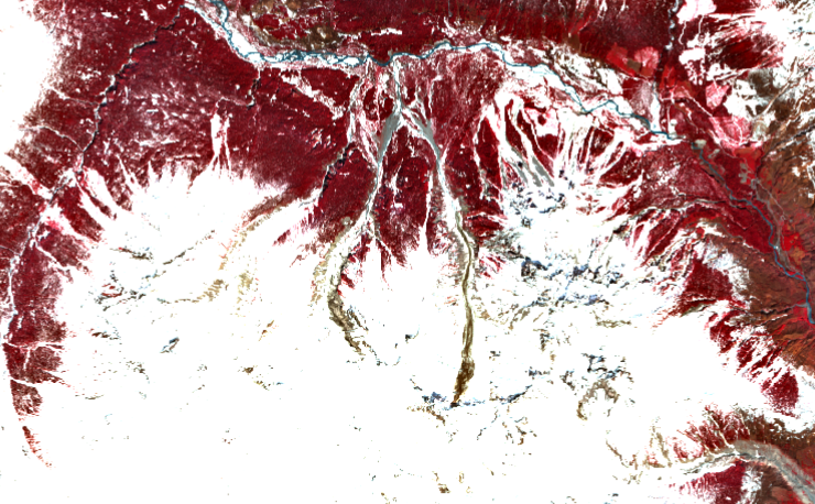
The 12 May 2023 landslide from Mount Job in the Meager Volcanic Complex in British Columbia, Canada as shown on Sentinel-2 imagery.
.
The NOHRSC Equivalent Snow Water model and NOHRSC station data near the slide depict rapid snowmelt associated with the landside.
Yet another snow melt related landslide appears to have occurred on Mount Shasta in California [41.434027, -122.211978] on 12 May 2023, and can be seen in Sentinel-2 imagery:-
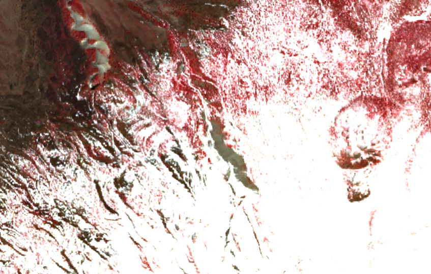
The 12 May 2023 landslide on Mount Shasta, as seen in Sentinel-2 imagery.
.
The NOHRSC Equivalent Snow Water model on 15 May 2023and NOHRSC station data from the Mount Shasta snow course station data for 1-30 May 2023 depict rapid snowmelt associated with the landside.
1 June 2023
El Molino: a valley-blocking landslide breach event in Colombia
El Molino: a valley-blocking landslide breach event in Colombia
Back in November I posted twice (here and here) about the very large, valley blocking landslide at El Molino in Colombia on 10 November 2022, which is located at [7.949, -73.025]. Five people were killed and 28 families were rendered homeless. Based on Planet imagery, I noted that “there is concern about the damming of the river as well as about the potential for a further landslide. A small lake has developed.”
Yesterday, Helbert Garcia-Delgado tweeted to that the lake had breached, creating a debris flow:
Apparently, a pond of approximately 38,000 m2 (satellite imagery provided below) was created as a result of the El Molino landslide (https://t.co/BPlFxSIgyK), but it has now been breached, leading to the initiation of a large-scale mass flow. No casualties reported so far. https://t.co/lmixLxwbYu pic.twitter.com/nM7g0QsdIe
— Helbert García-Delgado (@HelbertSchneid1) May 31, 2023
.
The video in the second tweet shows the aftermath of the resultant landslide. This is an area that is very difficult to image with satellites as cloud is very common, but fortunately Planet captured an image on 31 May 2023 that is mostly cloud free. So first, this is an image from 18 May 2023, showing the aftermath of the landslide and with the lake, located on the southern side margin of the landslide, intact:-
The El Molino landslide before the breach of the lake, as captured on 18 May 2023. Image copyright Planet, used with permission.
.
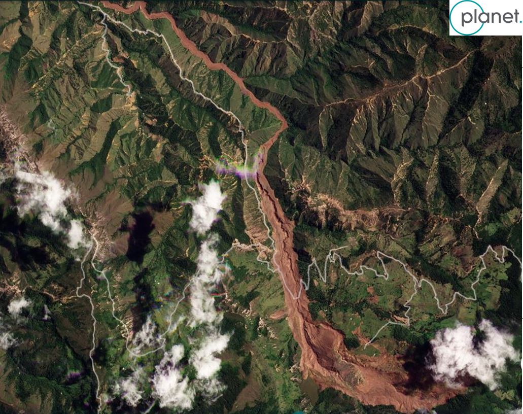
And here is the same site in an image dated 31 May 2023. showing the aftermath of the breach event:-
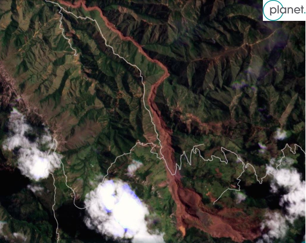
The El Molino landslide after the breach of the lake, as captured on 31 May 2023. Image copyright Planet, used with permission.
.
The image clearly shows that the lake has indeed breached and that most of the water has escaped, leaving a small muddy pool. The slider below should allow you to compare the two images, including the changes in morphology of the landslide caused by the debris flow:
.
La Opinion has a news report about the debris flow, which indicates that there has been extensive damage to farmland, houses and a bridge in the municipalities of Ábrego and Villa Caro.
.
Reference and acknowledgement
Planet Team (2023). Planet Application Program Interface: In Space for Life on Earth. San Francisco, CA. https://www.planet.com/
31 May 2023
Accelerating movement at Brienz/Brinzauls
Accelerating movement at Brienz/Brinzauls
The rate of movement of the large rockslope at Brienz/Brinzauls in Switzerland is continuing to accelerate, but it remains difficult to know exactly what will happen and when. There is now a Youtube live stream of the slope, which should be visible below, via Blick TV | Municipality Albula/Alvra:-
.
Regular rockfall activity is occurring on the slope – indeed yesterday there was a large detachment, which was caught on the webcam.
Last week, local government released a briefing to the local residents about the landslide, which has been posted online. It’s in German but Google Translate is helpful. Particularly interesting are graphs of the landslide movement history. First is a graph of the movement of the landslide back to 2019, with the y-axis scale being in centimetres per year:-
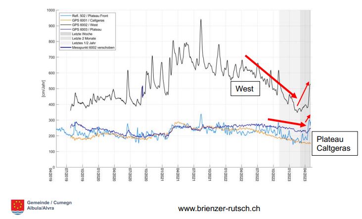
Long term movement history of the Brienz/Brinzauls landslide. Graph from a presentation by Gemeinde/Cumegn Albura/Alvra.
.
The marked acceleration in the landslide that occurred during 2020 is clear, as is the recent acceleration of portions of the landslide.
The presentation also includes ground-based radar data that captures the portion of the slope that is now mobile – in this case the colour scale is in mm per day:-
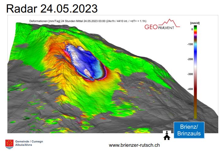
Radar data showing the movement rate of the Brienz/Brinzauls landslide. Graph from a presentation by Gemeinde/Cumegn Albura/Alvra.
.
As the image shows, it is not the whole of the landslide that is moving, but a portion in the centre of the slope that is termed “The Island” by the local geologists. The presentation includes recent data for the movement of this portion of the slope:-

Short term movement history of the Brienz/Brinzauls landslide. Graph from a presentation by Gemeinde/Cumegn Albura/Alvra.
.
The monitoring team note that the acceleration of the slope over the previous two weeks had been linear, which makes extrapolation of likely future patterns quite difficult, with a range of scenarios being possible. One possibility is that the slope fails in a series of rockfalls, whilst another is a full failure of the mobile mass (which could even destabilise more of the slope). In the meantime, the area around the slope remains cordoned off, although there are reports of people trying to access the cycling routes.
The best case scenario at Brienz/Brinzauls is that the slope fails in a series of smaller events in the coming days, removing the weak mass from the slope without destroying the village. At this point it is difficult to forecast how likely this is to play out. We watch with great interest.
25 May 2023
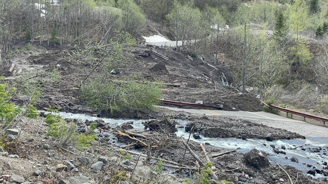
The 14 May 2023 debris flow at Johnston Ridge Observatory Access Road, Mount Saint Helens
The 14 May 2023 debris flow at Johnston Ridge Observatory Access Road, Mount Saint Helens
Guest post by loyal reader Funkenbeachin
On the evening of 14 May 2023, rapid snowmelt in response to unusually warm weather contributed to the occurrence of a large debris slide [46.2807, -122.1906] and debris flow that damaged the access road, State Route 504 [46.2822, -122.1952], to the Johnston Ridge Observatory at Mount Saint Helens in Washington, USA. Twelve people and a dog were evacuated by helicopter the following day.
King 5 Seattle television provided helicopter views of the debris slide and damage in the channel of South Coldwater Creek, tributary to the Toutle River: https://www.youtube.com/watch?v=aSX1Z1KBN54
The author has put together a video of the topography of the site using Lidar and aerial imagery, which also includes meteorological data at the end: https://youtu.be/uRPwXvy-uOI
The debris-slide overlies the Spirit Lake Outlet Tunnel, designed to control overflow of Spirit Lake. The 12 meter diameter tunnel was drilled from the SR-504 bridge crossing [46.2822, -122.1952] to a 12 meter deep shaft on the shore of the lake [46.276447, -122.162624].
There is a gallery of images of the landslide, which includes the source area, on the WSDOT Flickr page:-
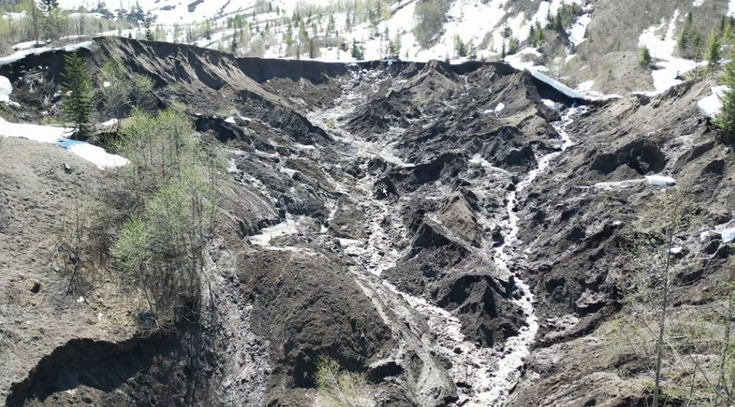
The source area of the Mount Saint Helens landslide on 14 May 2023. Image by WSDOT via Flickr.
.
Whilst this image shows the damage to the road:
Damage to the road after the Mount Saint Helens landslide on 14 May 2023. Image by WSDOT via Flickr.
.
Useful references
Grant, G., Major, J., Lewis, S., 2017, The Geologic, Geomorphic, and Hydrologic Context Underlying Options for Long-Term Management of the Spirit Lake Outlet Near Mount St. Helens, Washington. Pacific Northwest Research Station General Technical Report, PNW-GTR-954. https://www.fs.usda.gov/pnw/pubs/pnw_gtr954.pdf
Watts, A., 2019, The Spirit Lake dilemma: Engineering a solution for a lake with a problematic outlet. Science Findings, Issue 218, Portland, OR: U.S. Department of Agriculture, Forest Service, Pacific Northwest Research Station.
https://www.fs.usda.gov/pnw/sciencef/scifi218.pdf
.
Acknowledgement
Many thanks to Ken for pulling this together at a very busy time for me, and to others for contacting me about it.
23 May 2023
Planet images of the landslide at Draper in Utah
Planet images of the landslide at Draper in Utah
A couple of weeks ago I wrote about the urban landslide that occurred at Draper in Utah on 22 April 2022. This landslide occurred on an engineered slope, destroying two recently constructed houses. My friends at Planet have succeeded in collecting high resolution satellite images of the site. This is an image dated that shows the location before the major failure:-
Planet SkySat image of the site of the 22 April 2023 landslide at Draper in Utah. Image copyright Planet, used with permission. Image dated26 June 2022.
.
This is the same site captured after the 22 April 2023 failure:-
Planet SkySat image of the 22 April 2023 landslide at Draper in Utah. Image copyright Planet, used with permission. Image dated 27 April 2023.
.
The slider below should allow you to compare the two images directly.
.
Since my original post, there have been some developments at the Draper landslide. First, perhaps unsurprisingly, the house that was critically damaged but still standing was demolished on 26 April 2023 by the developer, Edge Homes. Meanwhile, an initial assessment of the site indicated that the remaining houses were not at a high level of risk. There is an interesting report about a town hall meeting with leaders of Draper city, which suggest that planning regulations are a critical weakness:-
City leaders first took about 20 minutes to discuss the city’s role in the landslide. They reiterated the fact that property rights allow people to build on their land. David Dobbins, Draper city manager, said there have been several subdivisions the city hasn’t felt right about building on, but they don’t have the capability to stop it without facing a lawsuit. He said that cost would be passed on to Draper taxpayers.
To a European like me this is hard to understand. Loyal reader Funkenbeachin has put together a video of the topography of the site using Lidar and aerial imagery, which also includes meteorological data at the end:-
.
The Draper landslide was just one of a series of failures in the region. Over 100 sites are reported to be showing signs of instability.
.
Reference
Planet Team (2023). Planet Application Program Interface: In Space for Life on Earth. San Francisco, CA. https://www.planet.com/
16 May 2023
Planet images of the Lake Kivu landslides in the DRC
Planet images of the Lake Kivu landslides in the DRC
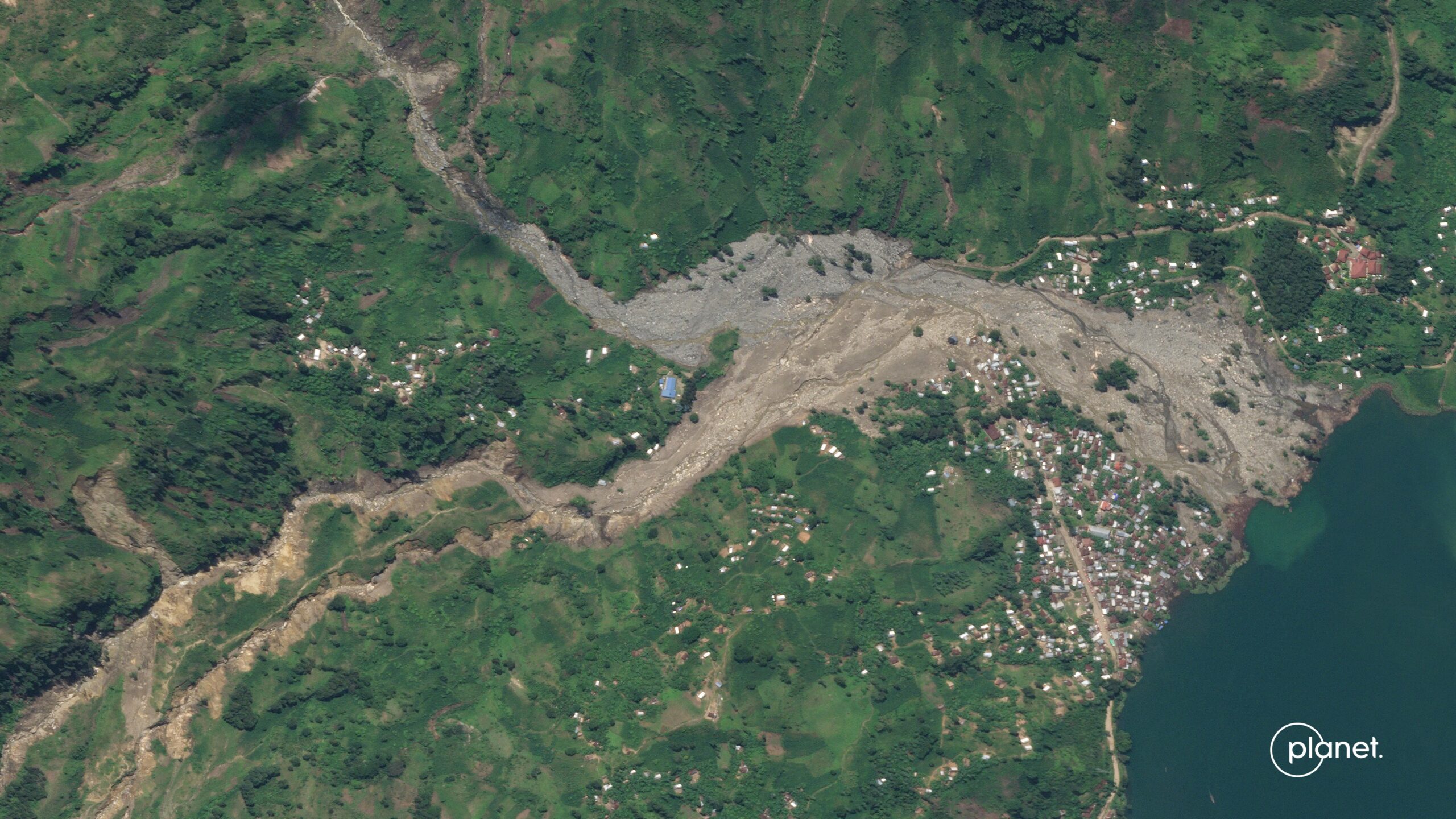
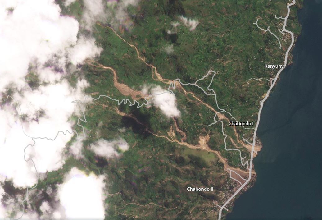
Planet has been able to collect a set of SkySat images of the Lake Kivu landslides in the Democratic Republic of Congo (DRC). This is an image of the area around Chabondo, which was hit by multiple channelised debris flows:-
Planet SkySat image of the Lake Kivu landslides in the Democratic Republic of Congo. This image shows the area around Chabondo. Image copyright Planet, used with permission.
.
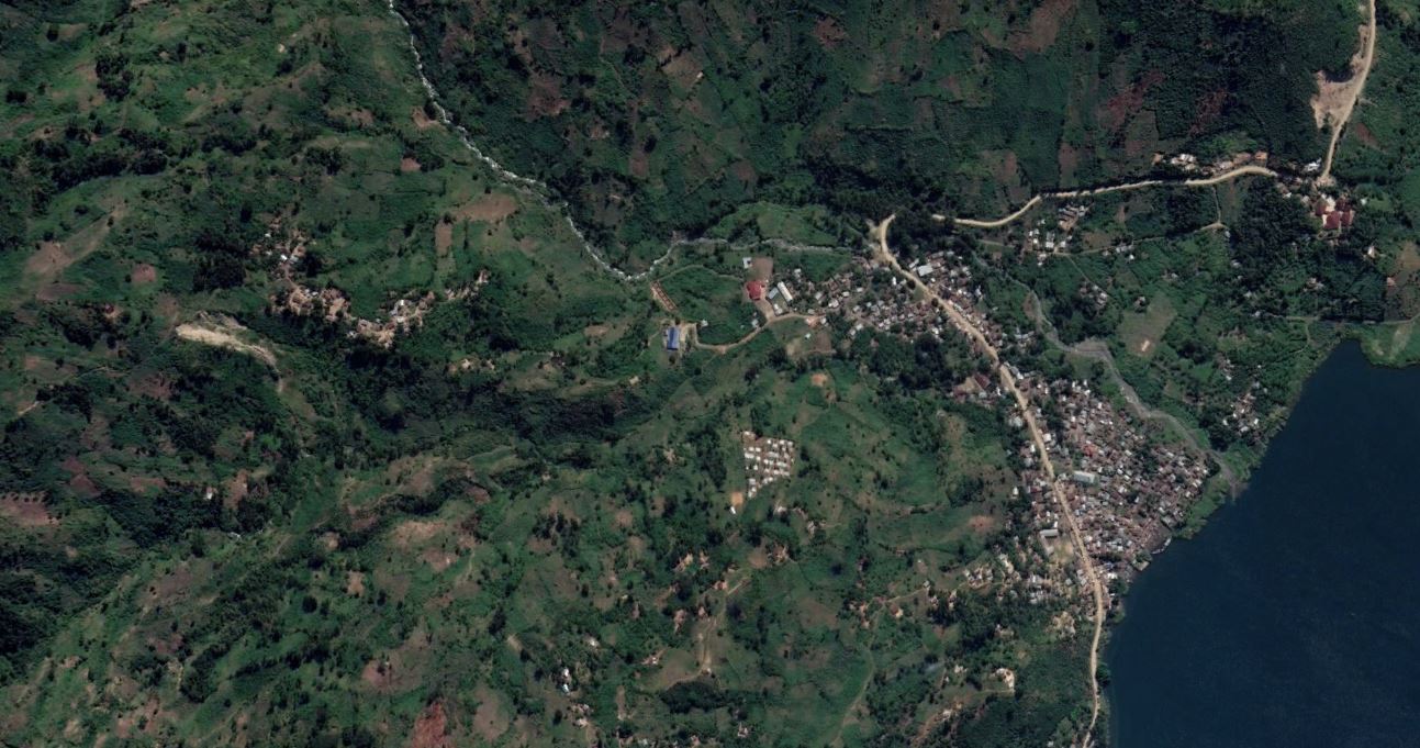
For reference, this is a Google Earth image of the same location, captured in 2019:-
Google Earth image from 2019 showing the site of the Lake Kivu landslides at Chabondo.
.
This is a classic set of channelised debris flows that have flowed across the debris fan upon which the houses were built. The location was clearly high risk, and indeed there is an earlier debris flow track in the 2019 image. The Planet image shows that any building in the path of the landslides was destroyed.
The image below shows the track of these landslides, which have travelled several kilometres. The form is complex, with multiple sources and, in one case, connection between the major flows:
Planet SkySat image of the Lake Kivu landslides in the Democratic Republic of Congo. This image shows the area upstream of Chabondo. Image copyright Planet, used with permission.
.
The image illustrates the extreme power of the landslides.
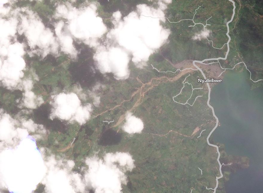
Planet has also captured a high quality image of the landslides at Nyabibwe:-
Planet SkySat image of the Lake Kivu landslides in the Democratic Republic of Congo. This image shows the area around Nyabibwe. Image copyright Planet, used with permission.
.
Once again, this is a Google Earth image for reference, from 2018:-
Google Earth image from 2019 showing the site of the Lake Kivu landslides at Nyabibwe.
.
The devastation to a large number of houses is painfully clear.
CNN reported on 11 May 2023 that the death toll from these events was at least 438 people, but that 1,000 more were missing. Other reports suggest a higher toll, but are unlikely to be correct. Meanwhile, a further landslide occurred at Vuveyi Lac in North Kivu on 9 May 2023, killing 10 people. There were also reports of a landslide at the Songambele mine, near Rubaya in North Kivu, killing at least six people. Some reports suggest that over 100 people may have been killed. Videos have posted to Twitter that allegedly show this event (I am unsure as to whether this is indeed the landslide), and the true picture remains very unclear:-
#URGENT: Quand l'inondation de Kalehe est en cours. Plusieurs sources locales à Bisunzu, près de Rubaya indiquent qu'un éboulement de terre a touché cette région ce lundi 08 mai. Le bilan n'est pas encore connu mais c'est près d'une dizaine de creuseurs artisanaux. #RDC pic.twitter.com/tmhdZXQ6bc
— Akilimali S. Chomachoma (@akilimalichoma_) May 8, 2023
.
Reference
Planet Team (2023). Planet Application Program Interface: In Space for Life on Earth. San Francisco, CA. https://www.planet.com/
10 May 2023
The very large incipient rockslide at Brienz in Switzerland
The very large incipient rockslide at Brienz in Switzerland
In the Swiss canton of Graubünden, a village named Brienz (or Brinzauls) in the municipality of Albula/Alvra has been evacuated due to an incipient, large rockslide. The BBC has a good write up of the situation – the slope above the village, and indeed under the settlement itself, shown below, has been moving for many years, but has accelerated in recent months. Parts of the slope are reported to be moving at 32 metres per year, and the mobile volume is about 2 million m³.
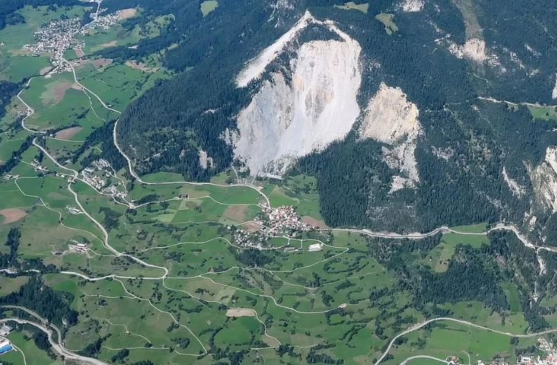
The rockslide above Brienz in eastern Switzerland. Image by CHRISTOPH NÄNNI, TIEFBAUAMT GR, SWITZERLAND via the BBC.
.
Swissinfo has a more detailed description of the situation in the village:-
The municipality in canton Graubünden has activated the “orange phase” and therefore the evacuation of the village, which has a population of about 130.
As of Friday evening nobody will be allowed to stay overnight in the village until further notice. From Saturday villagers will be allowed into Brienz/Brinzauls during the day, if the danger level permits. Livestock from two farms will remain in the stables for the time being, the authorities said.
All access roads to Brienz/Brinzauls are now open only to residents and homeowners. On Tuesday evening the authorities will provide information on the details of the evacuation during a public information event in the nearby village of Tiefencastel.
The local authority has a detailed site dedicated to the rockslide (in German). It notes that the landslide, which includes the village itself, has been moving since the ice age, with movement rates of a few centimetres per year. It accelerated about 20 years ago, with movement rates until the current crisis of about a metre per year.
Some research on the landslide at Brienz has been published (Häusler et al. 2021), noting that the landslide is part of a much larger area of deep-seated gravitational slope deformation. The paper includes this image that summarises the setting of the landslide:-
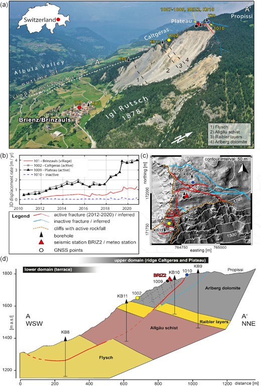
Overview of the Brienz landslide by Häusler et al. (2021).
Original caption: Overview of the deep-seated landslide at Brinzauls, with focus on the Plateau subdomain. (a) Photograph of the Brinzauls rock instability (view towards northwest) with drilling locations, GNSS (Global Navigation Satellite System) monitoring positions and seismometer location. (b) Displacement time-series at selected locations marked on panel (a). (c) Elevation model and simplified geomorphological map of the Plateau (see Fig. S1 for details). (d) Geological profile along the ridge Caltgeras. Photograph panel (a) by courtesy of SRF Einstein. Elevation model in panel (c) provided by courtesy of AWN. Coordinate frame LV03 (WGS84: 46.679, 9.593).
.
Predicting the short term behaviour of very large, complex landslides in extremely challenging, as was shown in the Mannen rockslide in Norway. That this slope will eventually fail is close to being certain, but when and exactly how is less clear. Those involved in Switzerland are doing a fine job of managing the risk and of keeping the pubic informed.
.
Acknowledgement
Thanks to Charles Hunt for highlighting this one to me.
.
Reference
Häusler, M., Gischig, V., Thöny, R., Glueer, F. and Donat, F. 2021. Monitoring the changing seismic site response of a fast-moving rockslide (Brienz/Brinzauls, Switzerland). Geophysical Journal International, 229 [1], 299–310, https://doi.org/10.1093/gji/ggab473
9 May 2023
The deadly mud and debris flows around Lake Kivu in the Democratic Republic of Congo
The deadly mud and debris flows around Lake Kivu in the Democratic Republic of Congo
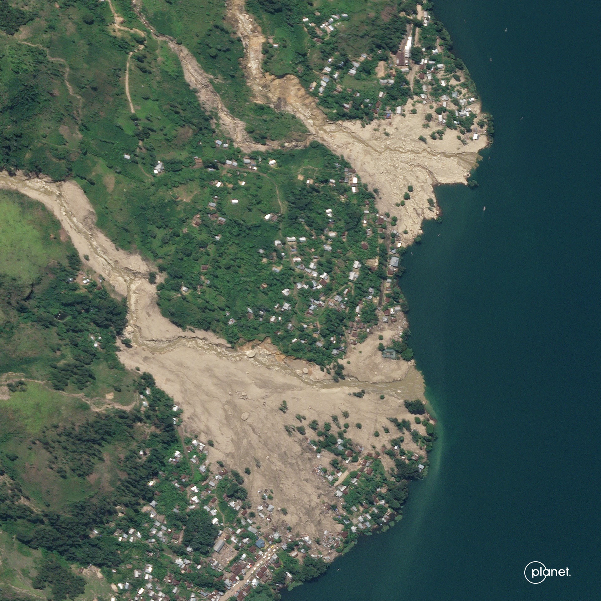
On Thursday 4 May 2023, intense rainfall triggered a series of deadly mud and debris flows around Lake Kivu in the Democratic Republic of Congo (DRC). At the time of writing the number of people killed is known to be at least 401, although this might still increase. As such, this is the worst landslide disaster of 2023 to date.
The events are reported to have destroyed the villages of Bushushu and Nyamukubi, although reports also indicate that the villages of Luzira and Chabondo were impacted too. However, there is often some complexity in the determination of the names of the places affected these types of events.
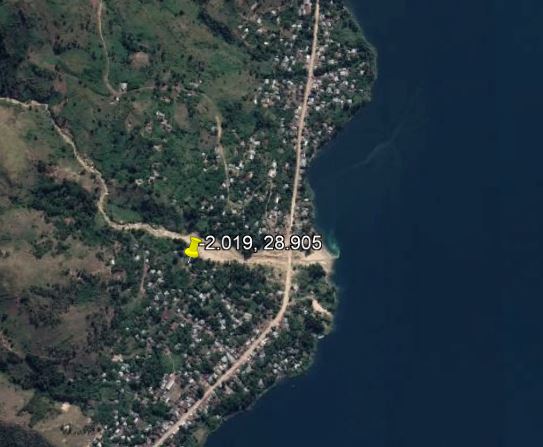
Planet has captured a set of satellite images that capture the scale of the disaster. This image, dated 8 May 2023, shows multiple channelised mud and debris flows originating on the slopes above Lake Kivu. Many of the houses are built on the debris fans from previous events, and have been over-run by this disaster. The location of this site is [-2.019, 28.905].:-
Multiple channelised mud and debris flows on the banks of Lake Kivu in the Democratic Republic of Congo. Image copyright Planet, used with permission, dated 8 May 2023.
.
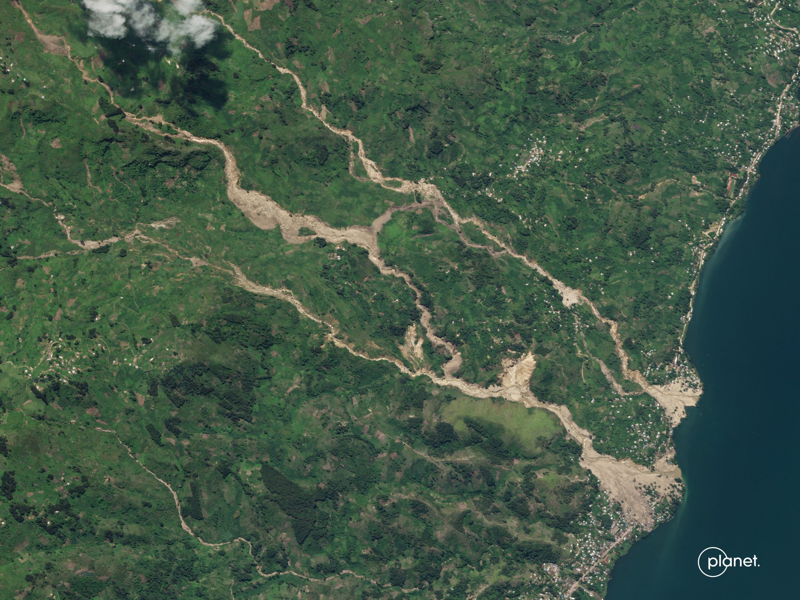
Further to the north, there is another set of landslides, this time captured on slight less good imagery from 7 May 2023. The location of this landslide is [-1.966, 28.910]:-
Multiple channelised mud and debris flows on the banks of Lake Kivu in the Democratic Republic of Congo. Image copyright Planet, used with permission, dated 7 May 2023.
.
In this case the impact on the town appears to be even greater, with a large number of houses destroyed.
UNOSAT has produced an initial map of these events, also from satellite imagery:-
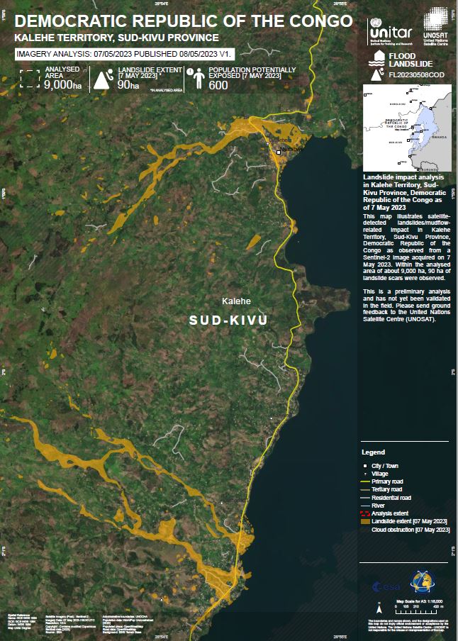
UNOSAT analysis of the multiple channelised mud and debris flows on the banks of Lake Kivu in the Democratic Republic of Congo.
.
The source of these flows is mostly hidden in cloud at present, but is likely to be shallow landslides.
Given the terrible landslides in Rwanda and Uganda last week, these events highlight the growing problem with landslides in parts of Africa.
.
Reference and acknowledgements
Planet Team (2023). Planet Application Program Interface: In Space for Life on Earth. San Francisco, CA. https://www.planet.com/
Thanks to Vishal Mishra on Twitter for highlighting the UNOSAT work.
4 May 2023
A heavy toll from landslides and floods in Rwanda and Uganda
A heavy toll from landslides and floods in Rwanda and Uganda
Heavy rainfall in recent days has caused extensive flooding and large numbers of landslides in Rwanda and Uganda. Worst hit has been Rwanda, where the toll is reported to be at least 129 people. The majority of the losses have occurred in Northern and Western Provinces, primarily in the districts of Ngororero (23 fatalities), Rubavu, Nyabihu (17 fatalities), Rutsiro (26 fatalities) and Karongi (16 fatalities) in Western Province. It is unclear as to the exact location of the landslides, but The New Times reports that four people were killed in a landslide in Rugerero sector, Rubavu district, whilst a further four people were critically injured.
This tweet appears to show landslides triggered by the rainfall, which fell on 2 and 3 May 2023:-
I am deeply sadned that more than 130 lost their lives due to the landslide and floods caused by heavy rains hit at night in Northern and Western provinces in Rwanda. pic.twitter.com/0oVEuGNdRt
— Mohamed A (@MohamedHachi99) May 3, 2023
.
Meanwhile, Uganda has also been hit hard. Uganda Radio Network indicated that 18 people were killed in Kigezi region, with the damage mainly occurring in Rubanda, Kisoro and Rukiga. It appears that deaths occurred in multiple landslides. This slope failure occurred in Murora, Kisoro district:-
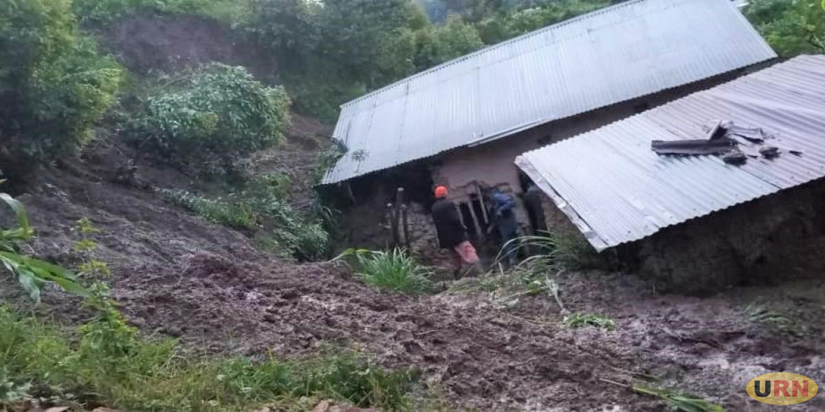
A landslide in Murora sub county, Kisoro district, Uganda. Image from Uganda Radio Network.
.
Both Rwanda and Uganda regularly suffer from substantial numbers of landslides triggered by heavy rainfall. For example, in 2018 at least 50 people were killed in Bududa in Uganda, whilst Karongi in Rwanda suffered a major landslide, also in 2018, which killed 18 people.
3 May 2023
A small but interesting landslide at Park City in Utah, USA
A small but interesting landslide at Park City in Utah, USA
The Park Record has an interesting story about a small landslide that occurred on a slope in Park City, Utah on 30 April 2023. Recently, I highlighted that there is an expectation of a increased landslide activity in Utah this Spring. The landslide occurred on a slope above a hotel, Marriott’s MountainSide, which was reportedly damaged. This image below, from the Park Record, shows the aftermath of the event:-
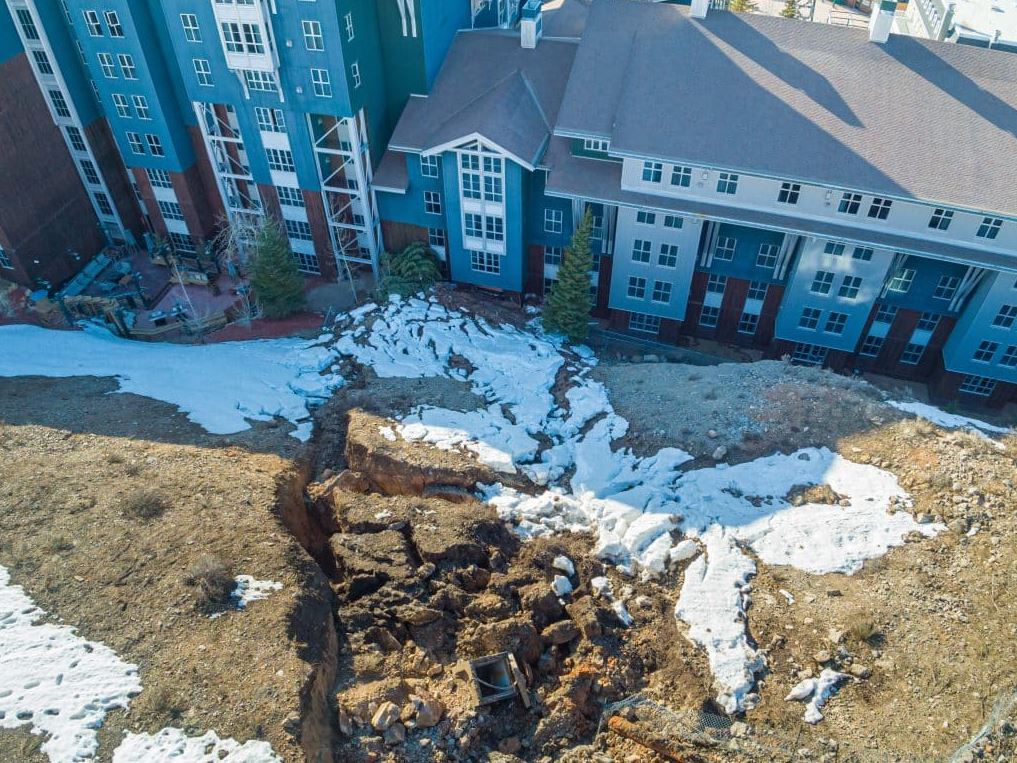
The 30 April 2023 landslide at Park City in Utah. Image from the Park Record.
.
The Park Record reports that the landslide is about 30 m long, 20 m wide and 4.5 m deep.
The Google Earth image below shows the site of the landslide in May 2022:-
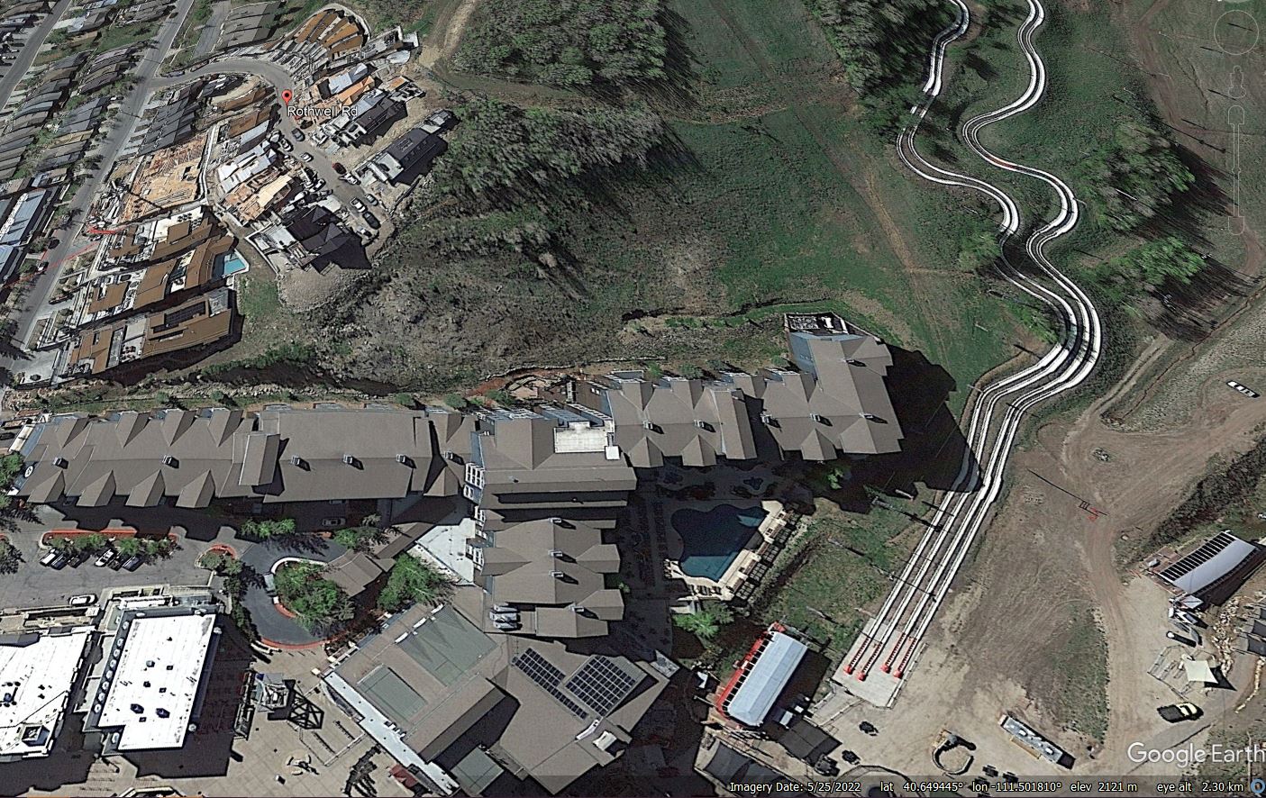
Google Earth image from 2022 showing the site of the 30 April 2023 landslide at Park City in Utah.
.
The hotel is the large building that runs across the lower part of the image, whilst the slope that failed is in the centre of the picture. Note the construction in the upper left quarter, above the slope – this is reportedly the King’s Crown development. The Park Record notes the proximity of the crown of the landslide to the construction work, which is consistent with the debris in the first image above.
The Google Earth image suggests to me that the slope that failed may have suffered previous instability – note the hummocky topography and the apparently steep scarps towards the top of the slope. The timing of the landslide suggests that snowmelt might have played a role, especially given the unusually high volumes of snow that have fallen this winter. The role of human activity is harder to determine – did the works at the top of the slope cause increased likelihood of failure, either by disrupting the drainage or by loading the crown of the landslide? Or did cutting of the toe of the slope remove support for the soil mass? A proper geotechnical investigation is needed with some urgency.
 Dave Petley is the Vice-Chancellor of the University of Hull in the United Kingdom. His blog provides commentary and analysis of landslide events occurring worldwide, including the landslides themselves, latest research, and conferences and meetings.
Recent Comments