
28 April 2023
Sand in Taufers: an interesting rockslide in Italy
Sand in Taufers: an interesting rockslide in Italy
On 24 April 2023 a large boulder was involved in an unusual rockslide in Sand in Taufers, a town located in the Taufers Valley in South Tyrol, northern Italy. The rockslide was captured on a surveillance video that was posted to Youtube. It is rather cool:-
https://twitter.com/LFVSuedtirol/status/1650487390593511431
.
This is quite an unusual rockslide in that it is a single boulder that is sliding, with no rotation, across the grass. This still from the video captures the motion:-
The 24 April 2023 rockslide at Sand in Taufers, Italy. Still from a video Tweeted by LFV Sudtirol.
.
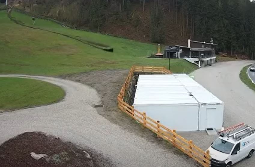
The boulder fortunately missed the large building – it was very close – but inconveniently came to a stop in the road. The Freiwilligen Feuerwehr Sand in Taufers Facebook site has some images of the boulder, its track and the efforts to reopen the road, including this image of the boulder itself:-
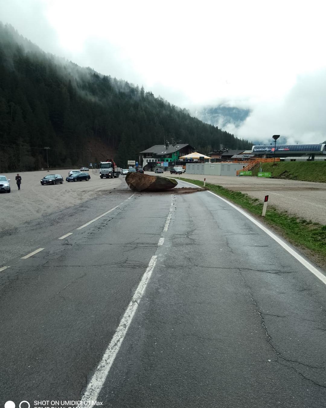
The boulder involved in the 24 April 2023 rockslide at Sand in Taufers, Italy. Image posted to Facebook by Freiwilligen Feuerwehr Sand in Taufers.
.
The location of this event was [46.933, 11.938]. The slope is the foot of a ski area that only recently closed at the end of the season. This is the Google Earth perspective on the site:-
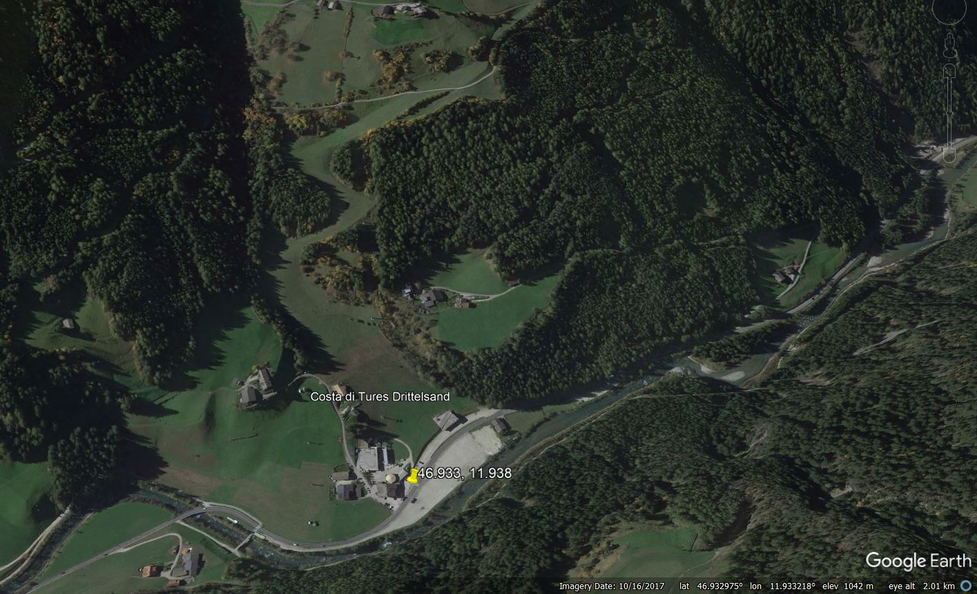
Google Earth view of the site of the 24 April 2023 rockslide at Sand in Taufers, Italy
.
The unusual movement of this boulder, which looks to be akin to surfing, is probably a combination of the surface properties – grass growing on wet soil that allowed the boulder to slide – and the tabular shape of the boulder itself, which inhibited rotation. I am not sure as to the origin of the boulder, but news articles indicate that another potentially unstable block has been identified and will be made safe.
.
Acknowledgement
Thanks to André Stumpf for drawing this most interesting video to my attention.
27 April 2023
The 25 April 2023 landslide Bukit Tunku in Malaysia
The 25 April 2023 landslide Bukit Tunku in Malaysia
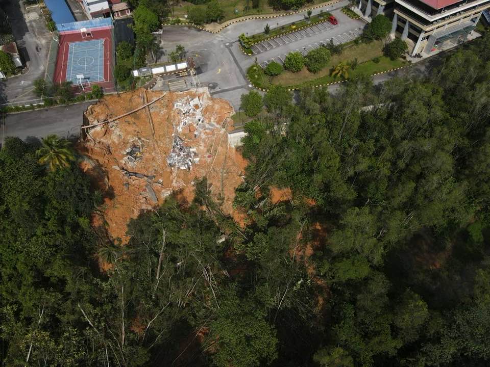
On 25 April 2023 a landslide occurred at the site of the Malaysian Anti-Corruption Academy (MACA) at Persiaran Tuanku Syed Sirajuddin, in Bukit Tunku, a part of Kuala Lumpur, in Malaysia. JBPM (the Fire and Rescue Department of Malaysia) has posted a gallery of image of the aftermath of this landslide onto their Facebook page, which includes these two images of the failure:-
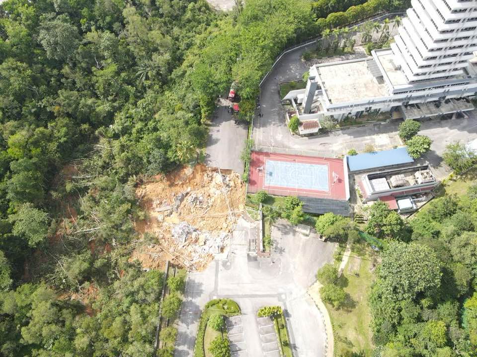
The 25 April 2023 landslide at Bukit Tungu in Malaysia. Image posted to the JBPM Facebook site.
.
The 25 April 2023 landslide at Bukit Tungu in Malaysia. Image posted to the JBPM Facebook site.
.
Fortunately there was no loss of life, although a security post was destroyed. I think the location of this landslide is [3.1677, 101.6722]. The Google Earth image below, which shows the site, displays no evidence of distress in the structures and roads:-
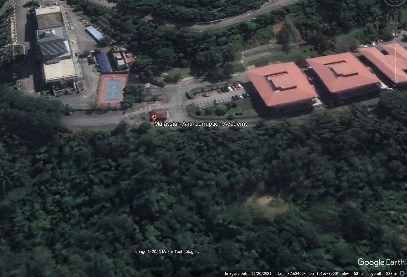
Google Earth image of the site of the 25 April 2023 landslide at Bukit Tungu in Malaysia.
.
The Slopes Division of the Public Works Division (JKR) is investigating the landslide. The Malay Mail reports that:
“Public Works Minister Datuk Seri Alexander Nanta Linggi said based on preliminary investigations by the Public Works Department (JKR) slope department, a leak in the underground water pipe most likely caused the landslide.”
However, there is also a suggestion that pooled water following recent heavy rainfall may have played a role. The site has now been covered in tarpaulins to prevent water ingress during further heavy rainfall, and piling is underway to stabilise the site – presumably to prevent expansion of the landslide area.
Once again, this landslide has led to calls for greater capacity in Malaysia to deal with landslides, most notably in the Kuala Lumpur area. There is considerable expertise in slope management and engineering in Malaysia, but the observation that the risk is high is well made. This event highlights the critical importance of the management of drainage systems on slopes, especially when the materials are weak.
26 April 2023
Planet Labs image of the coseismic landslide near Islahiye in Turkey
Planet Labs image of the coseismic landslide near Islahiye in Turkey
There has been considerable interest in the landslides triggered by the 6 February 2023 Turkey-Syria Earthquake, and by its aftershocks. Analysis of these events continues. One of the more interesting landslides was triggered near to Islahiye in Turkey. This is a cloudy area, so obtaining a good quality image of it has been a challenge, but Planet succeeded in capturing a high resolution Skysat image earlier this month. This is the image:-
Satellite image of the valley-blocking landslide near Islahiye, Turkey. Image copyright Planet, used with permission. Image dated 5 April 2023.
.
As the image above shows, this is a large rockslide – it is about 500 metres from the crown to the toe and about 220 m wide. The location is 37.004, 36.592. This is how it looks in Google Earth:-
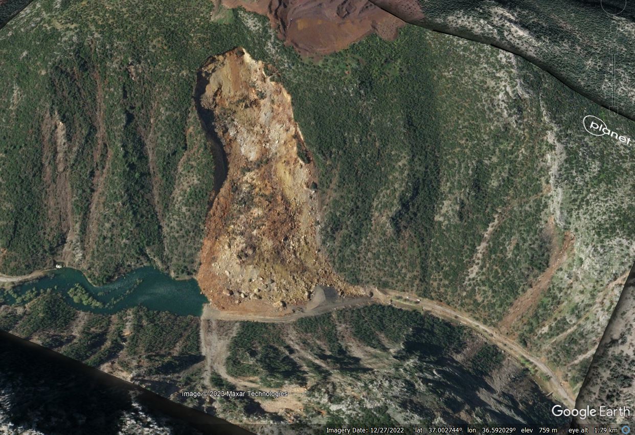
Satellite image of the valley-blocking landslide near Islahiye, Turkey, draped onto the Google Earth DEM. Image copyright Planet, used with permission. Image dated 5 April 2023.
.
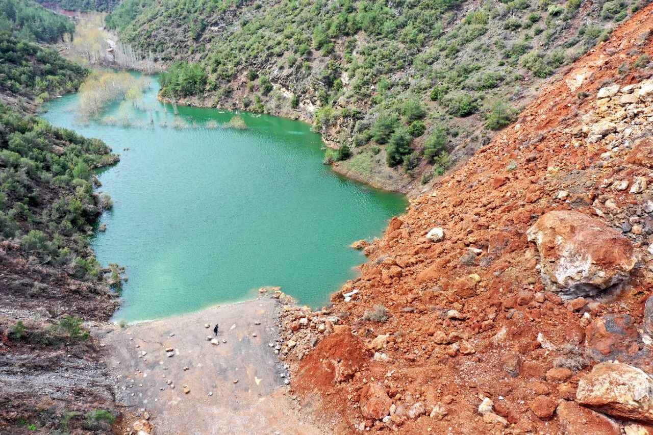
As the image shows, the landslide is valley-blocking., and a small lake has developed (this is about 400 metres long). There has been a little bit of coverage of this landslide in the Turkish media, for example Pusula has a short article from late March that includes this image:-
The valley-blocking landslide near Islahiye, Turkey. Image via Pusula.
.
Meanwhile, an article in Ensonhaber describes the work that has been undertaken, which can be seen in the image, to create a spillway. It includes this image of the crown of the landslide:-
The crown and upper reaches of the valley-blocking landslide near Islahiye, Turkey. Image from Ensonhaber.
.
The satellite images appear to indicate that the water level had not reached the spillway when the image was collected, but these prompt actions should ensure that an outburst flood, should it occur, will be manageable.
.
Acknowledgement and reference
Thanks as always to the great people at Planet for collecting this excellent image.
Planet Team (2023). Planet Application Program Interface: In Space for Life on Earth. San Francisco, CA. https://www.planet.com/
25 April 2023
The 22 April 2023 landslide in Draper in Utah
The 22 April 2023 landslide in Draper in Utah
Last week, the State Geologist of Utah, Bill Keach, warned of landslides in Utah this year. He made a prescient observation:
“We hope our engineering is better. But our urban sprawl has pushed us into areas where we weren’t built before.”
A few days later, on 22 April 2023, his warning came to pass when a landslide occurred in the town of Draper in Utah, destroying two houses. The event was captured on video that has been posted to Youtube:-
.
The landslide occurred on the Hidden Canyon Subdivision. There is some good drone footage of the aftermath of failure. KUTV has a good gallery of images, which includes this view of the upper-reaches of the landslide:-
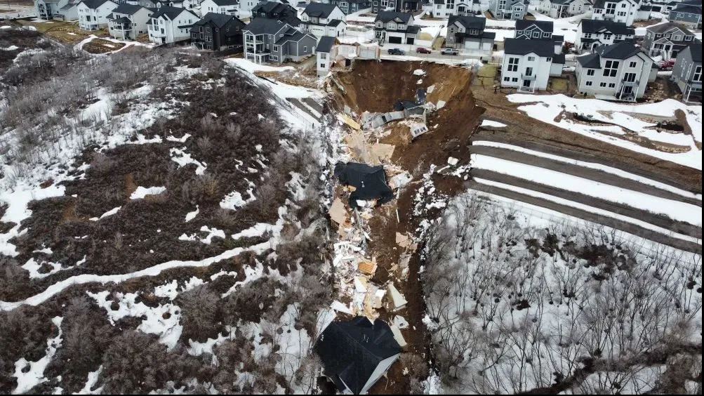
The aftermath of the landslide at Draper in Utah. Image from KUTV.
.
And this image looking down the landslide track:-
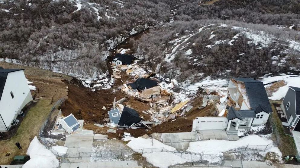
The aftermath of the landslide at Draper in Utah. Image from KUTV.
.
The second image shows a quite mobile landslide, presumably associated with the fine grained soils and the steep terrain.
The two destroyed houses were completed in December 2021 by a developer. Problems emerged in early 2022, as described in a news report on KSL TV from December 2022, which highlights the development of cracks in the structure and in the surrounding ground. Attempts were made to stabilise the properties, but in October 2022 the owners were forced to vacate the buildings. The same report has a video about the site, which includes this still:-

The site of the landslide at Draper in Utah. Still from a drone video posted by KSL TV.
.
It appears that the location of the landslide is [40.486, -111.824]. The image above appears to show cracking of the engineered slope, most notably on the left hand side at the top of the slope. Google Earth imagery from 2020 hints at the reason for this slope – it appears to suggest that a large amount of fill has been emplaced to create the platform for the houses:-
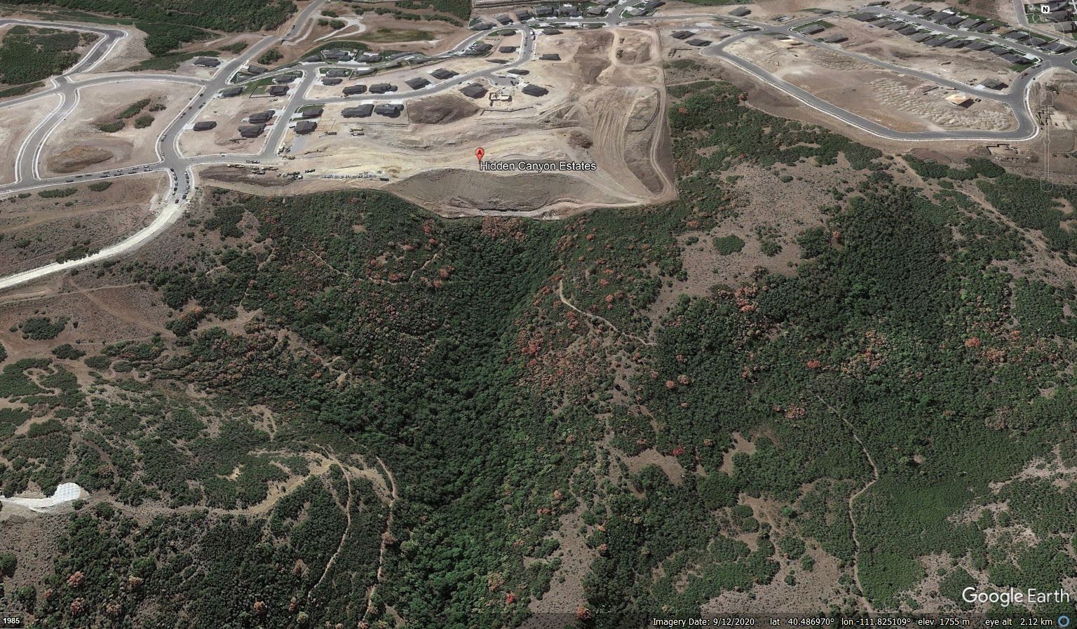
Google Earth image showing the site of the landslide at Draper in Utah.
.
Whilst the time of the Draper landslide might indicate that the snowmelt has played a role, the underlying cause will lie in the slope itself. There are two obvious possibilities – first, that the failure has developed in the fill slope itself; second, that the materials upon which the fill has been emplaced, which is likely to have had a volcanic origin, have failed.
Looking at the shape of the landslide I would tend towards the latter explanation, but a proper investigation is needed to verify the cause.
Clearly, this is a devastating event for the owners of the lost houses, and for the owners of the other two that have been evacuated. They are entirely blameless.
24 April 2023
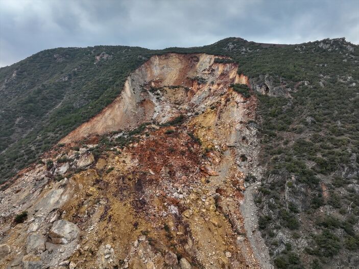
The 22 April 2023 landslide at Artvin in Turkey
The 22 April 2023 landslide at Artvin in Turkey
On 22 April 2023 a large landslide occurred at Artvin in Turkey. The failure was captured on a mobile phone and has been shared via social media. The longer version can be seen on Youtube and should be visible below.
.
As the video shows, the site of this landslide is an area of huge construction. This is part of the works for the Yusufeli Dam, a 540 MW hydroelectic scheme consisting of a 270 m tall, double-curvature arch dam. This will be the fifth highest dam in the world. Construction has been underway for a decade. The dam itself is located at [40.817, 41.645], but I am unsure as to the precise location of this landslide, which is reported to have been in the vicinity of Yansıticilar-Sakut.
The aftermath of the landslide is seen in the image below:-
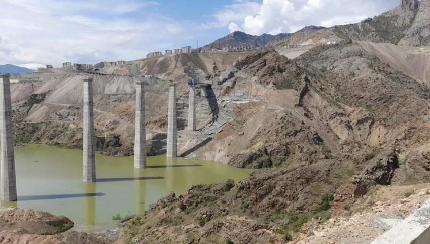
The aftermath of the landslide on 22 April 2023 in Artvin, Turkey. Image by Nusret DURUR/ARTVIN, (DHA) via Hurriyet.
.
The best indication as to the problem at this site can be gleaned from an image at the start of the video:-
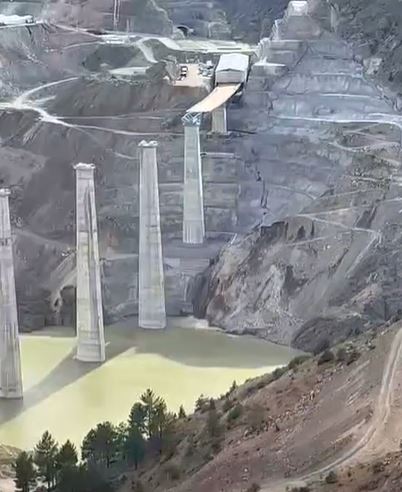
The early stages of the landslide on 22 April 2023 in Artvin, Turkey. Still from a video uploaded to Youtube.
.
The slope is clearly heavily engineered, with extensive benching. The reservoir level is currently being raised, as seen at the foot of the image. It appears that the lower part of the slope has already failed and has been removed, This appears to have debuttressed the remainder of the slope, which then undergoes quite a deep-seated failure. The majority of the movement is translational, but there is perhaps an element of rotation in the upper part of the slope.
Fortunately, the columns for the new highway appear to be unaffected, although the failure is close to two of them. There will inevitably be questions about the stability of the slope upon which the piers are standing, given the proximity to the failed slope, meaning that it will be essential to get a full understanding of the cause of this failure. The water level still has to rise a very large distance. Hurriyet hints that the failure had been anticipated.
Haberturk reports that “the viaduct works will continue as planned”.
21 April 2023
Post-seismic evolution of landslides in the Wenchuan earthquake area
Post-seismic evolution of landslides in the Wenchuan earthquake area
An area of great interest in landslide research in recent years has been the ways in which landslides evolve in the aftermath of earthquakes. It’s well-known that earthquakes trigger many landslides in mountain areas – sometimes tens of thousands of them. We also know that in some circumstances the number of landslides subsequently increases, most notably in the first very heavy rainstorm after the earthquake, as weakened slopes fail under conditions of high pore water pressure. What happens after this is less clear, and is probably dependent on the combination of topography, geology, earthquake magnitude and climate, amongst other factors.
The most spectacular coseismic landslide event of which I am aware was the 2008 Wenchuan Earthquake in China – we will reach the 15 year anniversary of this event next month. Landslides have been a very major issue in that area since the earthquake, most notably in the form of debris flows. A new paper published in the journal Engineering Geology (Zhang et al. 2023) has examined the evolution of debris flows in one area of the 2008 Wenchuan earthquake zone over a ten year period after the earthquake. Mapping was undertaken with multiple epochs of satellite data, allowing characterisation of 25 areas that has loose deposits present, and the determination of the normalized difference vegetation index (NDVI), which is a well-established way to assess the density of vegetation. The assumption was that the vegetation density is a proxy for landslide activity.
There is a lot of detail in the paper, but this diagram is worth highlighting:-
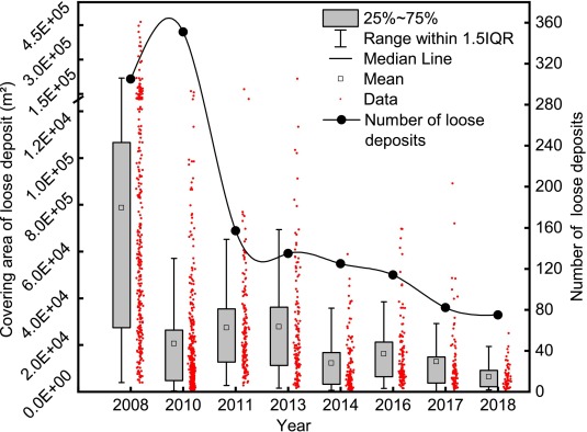
Graph indicating landslide activity in the area of the Wenchuan earthquake over time. Graph from Zhang et al. (2023).
.
This is an imperfect diagram, with both grammatical errors and, more importantly, real problems with the scaling of the x-axis. But the results are really interesting. Loose deposits are the source of the debris flows that has affected this area since the earthquake. The black line indicates the number of areas of loose deposits that were mapped, and the red dots indicate the surface area of each of those areas, with the box and whiskers summarising the latter data. The large number of loose deposits in the immediate aftermath of the earthquake is clear. In the first epoch after the earthquake this number increased, but the mean area of each area reduced. By 2011 the number had reduced dramatically whilst the mean area increased slightly. Thereafter, there was a steady decline in both indicators that continued throughout the remainder of the ten years.
The results support previous observations – the earthquake triggers many landslides, but that this subsequently gets worse due to heavy rainfall. The situation starts to recover thereafter – the data indicates that after three years the landslide sources have reduced significantly, perhaps in part because debris had been mobilised and removed, and in part because vegetation is recovering. However, the amount of landsliding remained elevated ten years after the earthquake – longer than was observed in Taiwan after the 1999 Chi-Chi earthquake for example – albeit on a declining trend.
.
Reference
Zhang, S., Peng, J.Y., Zhang, M.P. et al. 2023. Evolution of debris flow activities in the epicentral area, 10 years after the 2008 Wenchuan earthquake. Engineering Geology, 319, 107118. https://doi.org/10.1016/j.enggeo.2023.107118.
20 April 2023
The 26 November 2022 Casamicciola landslide on the island of Ischia in Italy
The 26 November 2022 Casamicciola landslide on the island of Ischia in Italy
On 26 Novmeber 2022, a substantial debris flow, now termed the Casamicciola landslide, was triggered by heavy rainfall on the island of Ischia in Italy. This landslide, which killed 12 people and injured several more, has been described in an initial but rigorous analysis (Romeo et al. 2023) published in the journal Landslides.
The analysis shows that the landslide had a volume of about 40,000 cubic metres, which is very large for a landslide through an urban area. There is excellent data on the landslide, including field mapping, remotely sensed data, high quality rainfall records from nearby and a seismic record that has captured the landslide movement. The authors have analysed 16 years of rainfall records, from 2006 to 2022. The rainfall event that triggered the landslide, was 176.8 mm in 24 hours, the highest total in the record. The second highest value, 111 mm in 24 hours in 2009, also triggered extensive landslides on Ischia.
There is a very interesting drone video on Youtube that shows the track of the landslide:-
.
This video includes this still, which captures the track of the landslide through the upper part of the town:-
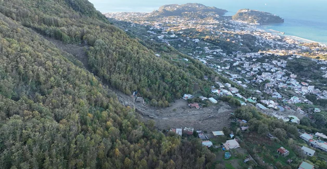
The track of the 26 November 2022 Casamicciola landslide on the island of Ischia in Italy. Still from a drone video posted to Youtube.
.
The authors conclude that the failure occurred in saturated debris high on the slope, with contributions from rockfalls and smaller debris flows along the track, The landslide turned into a classic channelised debris flow. Unfortunately deposition did not start until Casamicciola had been reached, meaning that the buildings took the full force of the flow. The peak velocity was in the range of 20 metres per second.
The timing of the landslide, which was one of several that occurred that day, may well have played a role in the loss of life. The landslide was triggered at about 5 am, when most people would have been asleep. Given the highly destructive nature of the landslide, there was little chance of escape.
.
Reference
Romeo, S., D’Angiò, D., Fraccica, A. et al. 2023. Investigation and preliminary assessment of the Casamicciola landslide in the island of Ischia (Italy) on November 26, 2022. Landslides https://doi.org/10.1007/s10346-023-02064-0
19 April 2023
Torkham – a large rockslide in Pakistan
Torkham – a large rockslide in Pakistan
On 18 April 2023, a large rockslide occurred at Torkham in Pakistan, very close to the border with Afghanistan. The landslide, which occurred in the early hours of the morning, struck a line of trucks waiting to cross the border. It is thought that about 20 trucks were buried in the accident. At the time of writing, three people are known to have been killed and a further eight people have been injured. Rescue operations continue, led by the army.
The best image that I have found of this landslide has been tweeted by Pakistan Armed Forces News:-
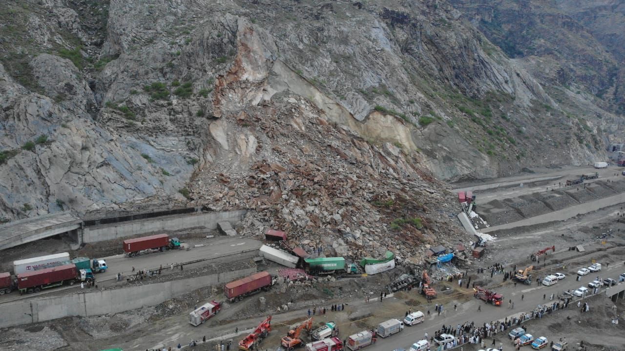
The 18 April 2023 landslide at Torkham in Pakistan. Image tweeted by Pakistan Armed Forces News.
.
The image shows a rockslide – based upon the scar it appears that the landslide has mobilised a set of discontinuities inclined parallel or sub-parallel to the slope. The debris appears to have bulldozed the trucks, and there is some evidence of the aftermath of a fire. Rescue operations will be very challenging as the boulders are large and of course removal of debris at the toe risks creating instability in the debris pile.
The location of the landslide is [34.115, 71.102]. This is a Google Earth image of the landscape, collected in October 2021:-
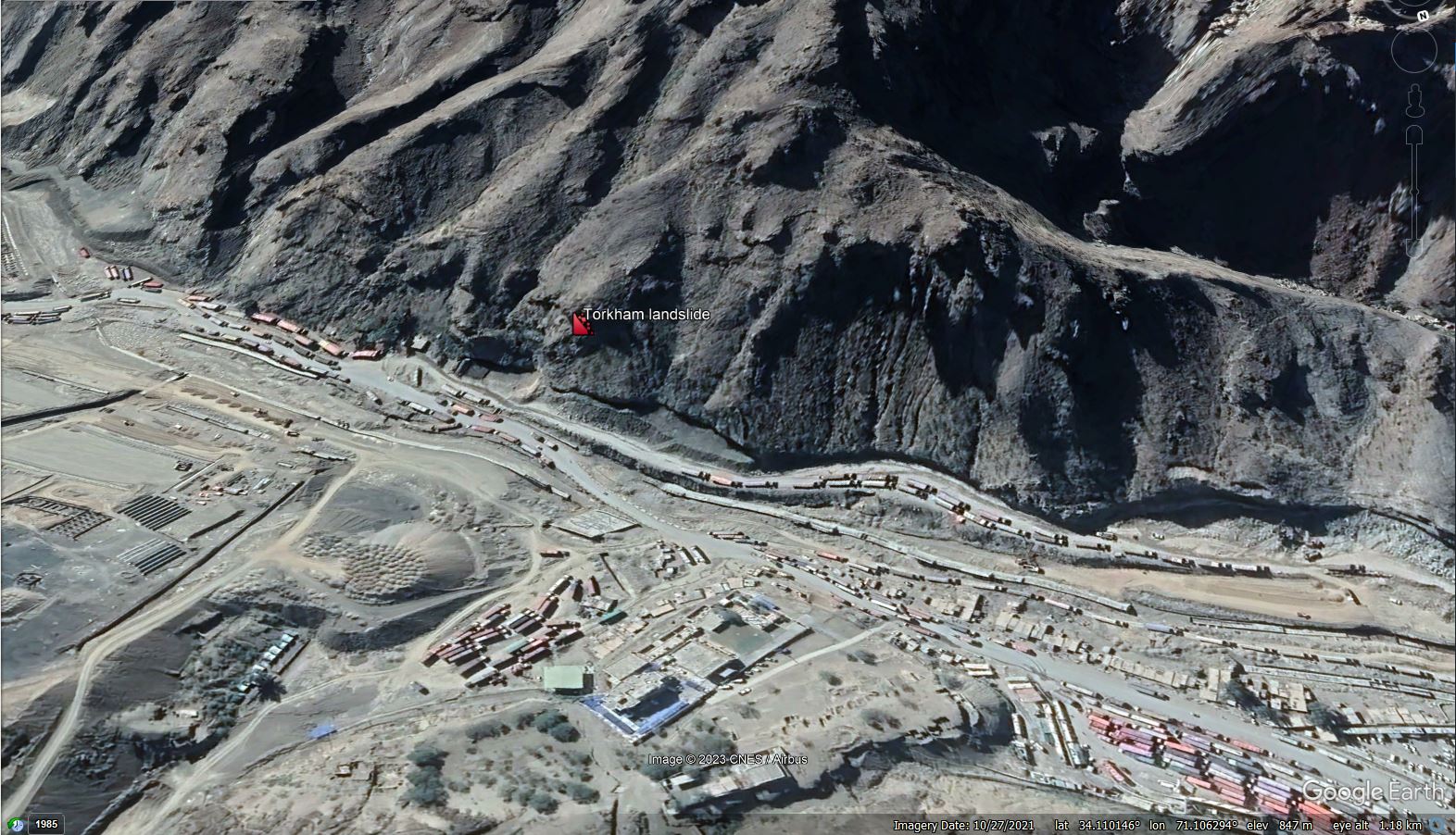
Google Earth view of the site of the 18 April 2023 landslide at Torkham in Pakistan.
.
Of interest here is the indication that the toe of the slope has been cut as part of construction works. By comparison, here is an image from 2016:-
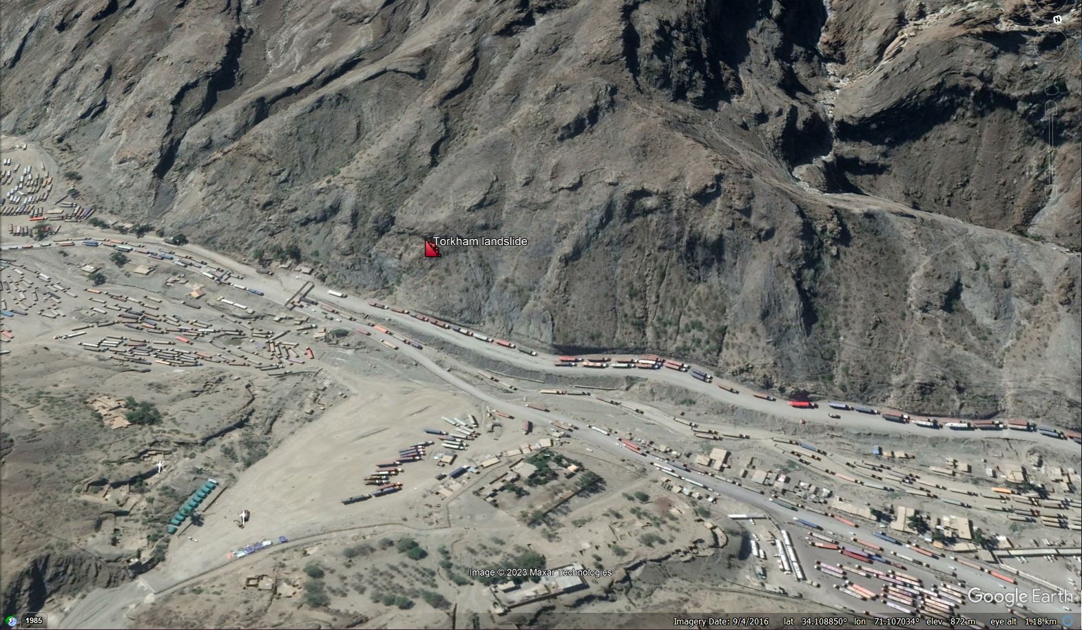
Archive (2016) Google Earth view of the site of the 18 April 2023 landslide at Torkham in Pakistan.
.
I have created a slider to allow the two images to be compared:-
.
It is unclear as to what has happened at the site since 2021 – there may be some evidence of the creation of concrete structures for the road – but a reasonable starting hypothesis could be that the cutting of the toe has enabled the instability.
News reports indicate that the landslide was triggered by a lightning strike. In most cases, such reports are erroneous, with the actual trigger being the very rainfall that accompanies the thunderstorm.
18 April 2023
Landslides as a dominant landscape process on icy satellites
Landslides as a dominant landscape process on icy satellites
The journal Icarus has a very interesting new paper (Mills et al. 2023) that considers why some icy satellites of large planets, such as those orbiting Jupiter and Saturn (in particular Ganymede, Europa, and Enceladus), have smooth surfaces with very few impact craters. There is a good plain English summary of this work on the Interesting Engineering website too. Conventionally, the theory has been that the smooth surfaces have been created by the eruption of fluids from volcanoes.

The topography of Ganymede, an icy satellite of Jupiter. Image NASA via phys.org
.
Interestingly, these icy satellites are known to be geologically-active, resulting from the high gravitational forces from the planets, which generate planetary seismic events (the equivalent of terrestrial earthquakes). This geological activity has created ridges, with smooth surfaces between them. The authors test the hypothesis that the seismic events trigger landslides from these ridges, which then mantle the surface of the icy satellite to create the smooth topography.
Mills et al. (2023) have used the dimensions of the fault scarps to estimate the magnitude of the seismic events (the ranger is M=4.0 to 7.9), and then have modelled the resulting seismic accelerations. These accelerations were found to be sufficiently large to exceed the gravitational accelerations of the satellites, allowing mass movements to develop. The team has assessed the potential volumes of the resultant landslides, using two different models. The more recent of these suggests that for Ganymede for example, the landslide volumes could be in the range of 2.3 × 10⁶–1.4 × 10⁹ cubic metres. It must be stressed that these are quite speculative – there are many assumptions implicit in that number – but it is a very interesting result.
There is much work to do on this idea, which will be greatly assisted by the forthcoming Europa Clipper and JUICE missions, which are intended to “provide high-resolution surface imaging, including stereo imaging, along with subsurface radar sounding, for both Europa and Ganymede”.
This study is another illustration of the key role that landslides play in planetary systems.
.
Reference
Mills, M.M., Pappalardo, R.T., Panning, M.P. et al. 2023. Moonquake-triggered mass wasting processes on icy satellites. Icarus, 399, 115534. https://doi.org/10.1016/j.icarus.2023.115534.
17 April 2023
The Arroyo Seco landslide in Monterey County, California
The Arroyo Seco landslide in Monterey County, California
Over the last week, concerns have been raised about a landslide that has developed in Arroyo Seco in Monterey County in California, USA. The best image I have found of the setting of the landslide was tweeted by Karl Cooke, a journalist with KION 5/46:-

An overview of the Arroyo Seco landslide in California. Image tweeted by Karl Cooke.
.
There is a more detailed image of the landslide itself in a drone video of the landslide that was posted to Facebook by Felix Cortez, who is a reporter for KSBW Action News 8:-
A view of the Arroyo Seco landslide in California. Still from a drone video posted to Facebook by Felix Cortez.
.
The local authorities have rightly closed the road at the foot of the slope. The landslide is being monitored by the USGS.
The trigger for the landslide is not clear, but California has suffered a series of major rainstorms through the winter and the spring. In January, the high level of the river necessitated a helicopter rescue for a couple living in the area.
This landslide might well be a substantial headache for the inhabitants of the area and the people trying to keep them safe. Movement of the slope is likely to be hard to predict. One scenario is that the slope fully fails, creating a debris pile that can be removed, albeit at substantial cost. A more difficult scenario is that the slope does not fully fail, leaving a hazard on the slope that will place the road at risk. Experience from elsewhere suggests that decision-making in this situation is a challenge.
A tweet from KION News Channel 46 provides a really nice 3D view of the slope. It appears that the failure is occurring on geological strata that dip in parallel to the slope?
ARROYO SECO FACES POSSIBLE LANDSLIDE
Read more: https://t.co/Ou057UOKNz pic.twitter.com/4WP4gNofLO— KION News Channel 46 (@KIONnews) April 13, 2023
 Dave Petley is the Vice-Chancellor of the University of Hull in the United Kingdom. His blog provides commentary and analysis of landslide events occurring worldwide, including the landslides themselves, latest research, and conferences and meetings.
Recent Comments