23 May 2023
Planet images of the landslide at Draper in Utah
Posted by Dave Petley
Planet images of the landslide at Draper in Utah
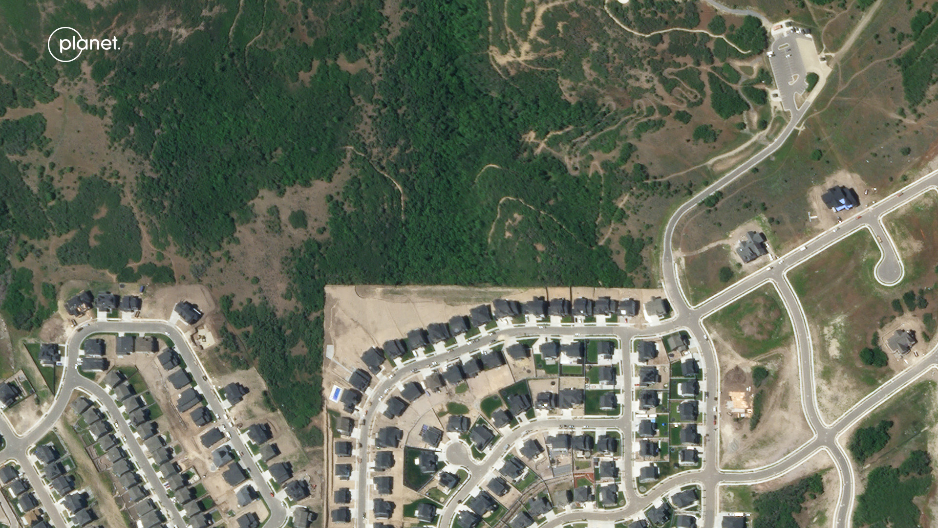
A couple of weeks ago I wrote about the urban landslide that occurred at Draper in Utah on 22 April 2022. This landslide occurred on an engineered slope, destroying two recently constructed houses. My friends at Planet have succeeded in collecting high resolution satellite images of the site. This is an image dated that shows the location before the major failure:-

Planet SkySat image of the site of the 22 April 2023 landslide at Draper in Utah. Image copyright Planet, used with permission. Image dated26 June 2022.
.
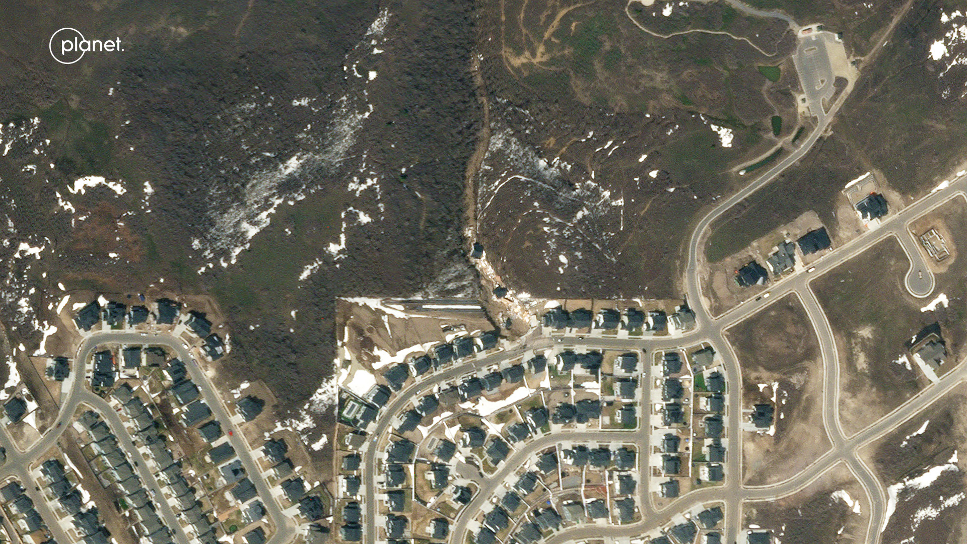
This is the same site captured after the 22 April 2023 failure:-

Planet SkySat image of the 22 April 2023 landslide at Draper in Utah. Image copyright Planet, used with permission. Image dated 27 April 2023.
.
The slider below should allow you to compare the two images directly.


.
Since my original post, there have been some developments at the Draper landslide. First, perhaps unsurprisingly, the house that was critically damaged but still standing was demolished on 26 April 2023 by the developer, Edge Homes. Meanwhile, an initial assessment of the site indicated that the remaining houses were not at a high level of risk. There is an interesting report about a town hall meeting with leaders of Draper city, which suggest that planning regulations are a critical weakness:-
City leaders first took about 20 minutes to discuss the city’s role in the landslide. They reiterated the fact that property rights allow people to build on their land. David Dobbins, Draper city manager, said there have been several subdivisions the city hasn’t felt right about building on, but they don’t have the capability to stop it without facing a lawsuit. He said that cost would be passed on to Draper taxpayers.
To a European like me this is hard to understand. Loyal reader Funkenbeachin has put together a video of the topography of the site using Lidar and aerial imagery, which also includes meteorological data at the end:-
.
The Draper landslide was just one of a series of failures in the region. Over 100 sites are reported to be showing signs of instability.
.
Reference
Planet Team (2023). Planet Application Program Interface: In Space for Life on Earth. San Francisco, CA. https://www.planet.com/


 Dave Petley is the Vice-Chancellor of the University of Hull in the United Kingdom. His blog provides commentary and analysis of landslide events occurring worldwide, including the landslides themselves, latest research, and conferences and meetings.
This is the key: “…there have been several subdivisions the city hasn’t felt right about building on, but they don’t have the capability to stop it without facing a lawsuit.”
I made my living as a young geologist working in California for a firm that provided Expert Witness services on sites precisely like this. Utah must be a Developers dream.
I budded as an engineering geologist in Orange County, California where a strong grading code part of the work environment. The geotechnology matured as coastal hillside tract development progressed from Los Angeles to San Diego. Search [orange county california grading code].
Here is snow water model data from the NOAA, National Weather Service, National Operational Hydrologic Remote Sensing Center (NOHRSC). There is a station G3226 Madis – G3226 Draper [40.48083, -111.8242], the Draper Landslide is [40.486, -111.824]. The April 1-22, 2023 data for the Draper station show 8 inches of snow water equivalent meltedHere is a in a few days about April 10: [https://www.nohrsc.noaa.gov/interactive/html/graph.html?station=G3226_MADIS&w=600&h=400&o=a&uc=0&by=2023&bm=4&bd=1&bh=18&ey=2023&em=4&ed=22&eh=18&data=0&units=0®ion=us]. Note the time scale of the plots can be adjusted.
Here is a map of snow water equivalent on April 7: [https://www.nohrsc.noaa.gov/interactive/html/map.html?ql=station&zoom=&loc=Latitude%2CLongitude%3B+City%2CST%3B+or+Station+ID&var=ssm_swe&dy=2023&dm=4&dd=7&dh=18&snap=1&o9=1&o12=1&o13=1&lbl=m&mode=query&extents=us&min_x=-112.05833333333&min_y=40.349999999996&max_x=-111.58333333333&max_y=40.616666666663&coord_x=-111.82083333333&coord_y=40.4833333333295&zbox_n=&zbox_s=&zbox_e=&zbox_w=&metric=0&palette=1&title=1&width=800&height=450&nw=800&nh=450&h_o=0&font=0&js=1&uc=0]. Note the Draper station can be located near the center of the map by mouse hovering over station symbols, click there to see the graphical data, Eight inches of liquid precipitation in a few days triggers my landslide alarm!
Like you, Dave,
I never grew up in American freedom ideology.
I’m from Oz and wine expect experts to have a say in what is reasonably practicable and reasonably safe.