
25 April 2023
The 22 April 2023 landslide in Draper in Utah
Posted by Dave Petley
The 22 April 2023 landslide in Draper in Utah
Last week, the State Geologist of Utah, Bill Keach, warned of landslides in Utah this year. He made a prescient observation:
“We hope our engineering is better. But our urban sprawl has pushed us into areas where we weren’t built before.”
A few days later, on 22 April 2023, his warning came to pass when a landslide occurred in the town of Draper in Utah, destroying two houses. The event was captured on video that has been posted to Youtube:-
.
The landslide occurred on the Hidden Canyon Subdivision. There is some good drone footage of the aftermath of failure. KUTV has a good gallery of images, which includes this view of the upper-reaches of the landslide:-
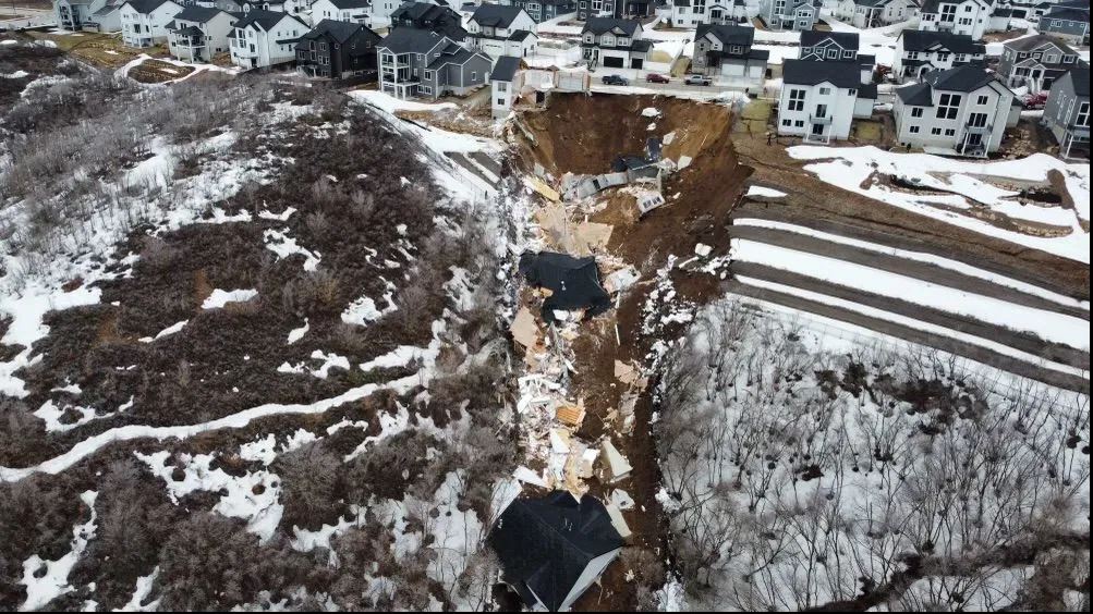
The aftermath of the landslide at Draper in Utah. Image from KUTV.
.
And this image looking down the landslide track:-
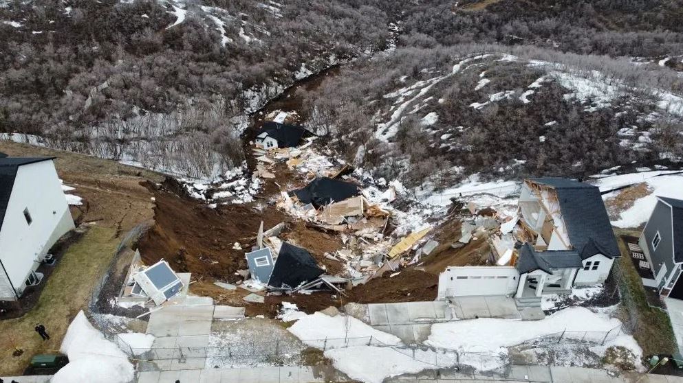
The aftermath of the landslide at Draper in Utah. Image from KUTV.
.
The second image shows a quite mobile landslide, presumably associated with the fine grained soils and the steep terrain.
The two destroyed houses were completed in December 2021 by a developer. Problems emerged in early 2022, as described in a news report on KSL TV from December 2022, which highlights the development of cracks in the structure and in the surrounding ground. Attempts were made to stabilise the properties, but in October 2022 the owners were forced to vacate the buildings. The same report has a video about the site, which includes this still:-
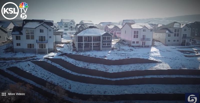
The site of the landslide at Draper in Utah. Still from a drone video posted by KSL TV.
.
It appears that the location of the landslide is [40.486, -111.824]. The image above appears to show cracking of the engineered slope, most notably on the left hand side at the top of the slope. Google Earth imagery from 2020 hints at the reason for this slope – it appears to suggest that a large amount of fill has been emplaced to create the platform for the houses:-
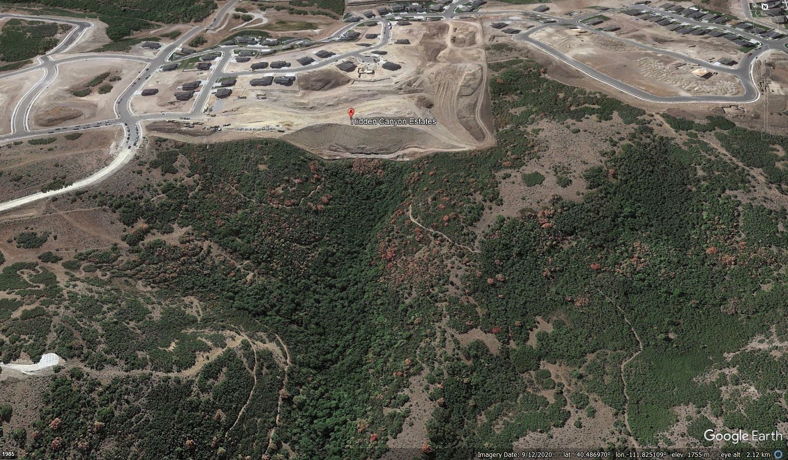
Google Earth image showing the site of the landslide at Draper in Utah.
.
Whilst the time of the Draper landslide might indicate that the snowmelt has played a role, the underlying cause will lie in the slope itself. There are two obvious possibilities – first, that the failure has developed in the fill slope itself; second, that the materials upon which the fill has been emplaced, which is likely to have had a volcanic origin, have failed.
Looking at the shape of the landslide I would tend towards the latter explanation, but a proper investigation is needed to verify the cause.
Clearly, this is a devastating event for the owners of the lost houses, and for the owners of the other two that have been evacuated. They are entirely blameless.
 Dave Petley is the Vice-Chancellor of the University of Hull in the United Kingdom. His blog provides commentary and analysis of landslide events occurring worldwide, including the landslides themselves, latest research, and conferences and meetings.
The Google Earth perspective view is distorted, appears that the DEM is older than the aerial imagery.
A search for the lat/lon [40.486, -111.824] of 1-meter Elevation Products (3DEP) in the USGS TNM https://apps.nationalmap.gov/downloader/#/
returns 7 pieces to the 2@1×1 kilometer tiles of the area of interest. Note they range in age from 2013 to 2020. There are 2 pieces dated 2013 in the immediate vicinity of the fill failure. The DEM may be prior to grading of the Hidden Canyon Subdivision.
Here is the cumulative precipitation plot for the current water year
https://www.weather.gov/images/slc/cliplot/KSLC2022b10plot.png
Edit the date in the URL to see earlier years. The source page is
https://www.weather.gov/slc/CliPlot
“Hidden Canyon Estates” is correct. It is hidden by fill.
They are following the time-honored California tradition of naming subdivisions after what USED to be there.
I wonder about adequate subdrainage in swale cases like these.
Here is an 8 minute Youtube video of aerial imagery, including a time series across the construction period, the slope map derived from and drape on 2013 USGS 1-meter DEM and the NWS climate plot for Salt Lake City: https://youtu.be/q93GrT96SxM
Dr. Kathleen Nicoll wrote about this area and landslides in 2010: https://collections.lib.utah.edu/details?id=704324
The site of the landslide is in the active Wasatch Fault zone, the eastern most normal fault of the Basin and Range Provence.
https://geology.utah.gov/map-pub/survey-notes/wasatch-fault-above/
https://en.wikipedia.org/wiki/Wasatch_Fault
Additional information:
The Draper grading code:
https://codelibrary.amlegal.com/codes/draperut/latest/draper_ut/0-0-0-35476
Orange County, coastal southern California mature grading code, evolved over the last 50 years of hill-side development:
https://ocds.ocpublicworks.com/sites/ocpwocds/files/import/data/files/75767.pdf
UMR story about grading code evolution in southern California since 1950: .
https://web.mst.edu/~rogersda/umrcourses/ge441/online_lectures/mass_grading/GE441-Lecture1-3.pdf
Los Angeles County Building Department grading code evolution since 1950:
https://dpw.lacounty.gov/bsd/lib/fp/Drainage%20and%20Grading/General%20Grading%20Documents/Grading%20History.pdf
The area were the houses collapsed appear to be an infilled gully. Filling in a natural drainage path always increases the risk of failure (water wants to go there naturally). Also the retaining walls look very simple with little geogrid (hard to tell, but definitely not a reinforced soil slope). Not familiar with volcanic origin soils, so it would be interesting the failure process these soils would be. Likely a number of factors that contributed to the failure.
The area were the houses collapsed appear to be an infilled gully. Filling in a natural drainage path always increases the risk of failure (water wants to go there naturally). Also the retaining walls look very simple with little geogrid (hard to tell, but definitely not a reinforced soil slope). Not familiar with volcanic origin soils, so it would be interesting the failure process these soils would be. Likely a number of factors that contributed to the failure.
A local geologist says much of the material involved is derived from volcanic ash.
https://www.ksl.com/article/50628300/utah-geologist-gives-exclusive-insight-into-draper-collapses