25 May 2023
The 14 May 2023 debris flow at Johnston Ridge Observatory Access Road, Mount Saint Helens
Posted by Dave Petley
The 14 May 2023 debris flow at Johnston Ridge Observatory Access Road, Mount Saint Helens
Guest post by loyal reader Funkenbeachin
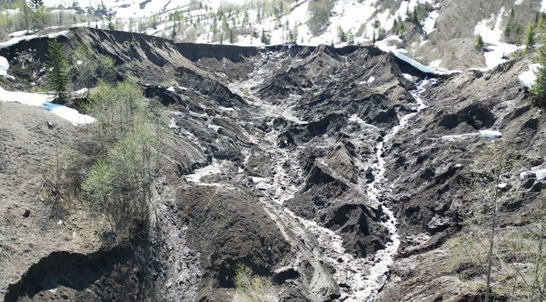
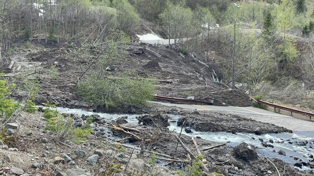
On the evening of 14 May 2023, rapid snowmelt in response to unusually warm weather contributed to the occurrence of a large debris slide [46.2807, -122.1906] and debris flow that damaged the access road, State Route 504 [46.2822, -122.1952], to the Johnston Ridge Observatory at Mount Saint Helens in Washington, USA. Twelve people and a dog were evacuated by helicopter the following day.
King 5 Seattle television provided helicopter views of the debris slide and damage in the channel of South Coldwater Creek, tributary to the Toutle River: https://www.youtube.com/watch?v=aSX1Z1KBN54
The author has put together a video of the topography of the site using Lidar and aerial imagery, which also includes meteorological data at the end: https://youtu.be/uRPwXvy-uOI
The debris-slide overlies the Spirit Lake Outlet Tunnel, designed to control overflow of Spirit Lake. The 12 meter diameter tunnel was drilled from the SR-504 bridge crossing [46.2822, -122.1952] to a 12 meter deep shaft on the shore of the lake [46.276447, -122.162624].
There is a gallery of images of the landslide, which includes the source area, on the WSDOT Flickr page:-

The source area of the Mount Saint Helens landslide on 14 May 2023. Image by WSDOT via Flickr.
.
Whilst this image shows the damage to the road:

Damage to the road after the Mount Saint Helens landslide on 14 May 2023. Image by WSDOT via Flickr.
.
Useful references
Grant, G., Major, J., Lewis, S., 2017, The Geologic, Geomorphic, and Hydrologic Context Underlying Options for Long-Term Management of the Spirit Lake Outlet Near Mount St. Helens, Washington. Pacific Northwest Research Station General Technical Report, PNW-GTR-954. https://www.fs.usda.gov/pnw/pubs/pnw_gtr954.pdf
Watts, A., 2019, The Spirit Lake dilemma: Engineering a solution for a lake with a problematic outlet. Science Findings, Issue 218, Portland, OR: U.S. Department of Agriculture, Forest Service, Pacific Northwest Research Station.
https://www.fs.usda.gov/pnw/sciencef/scifi218.pdf
.
Acknowledgement
Many thanks to Ken for pulling this together at a very busy time for me, and to others for contacting me about it.


 Dave Petley is the Vice-Chancellor of the University of Hull in the United Kingdom. His blog provides commentary and analysis of landslide events occurring worldwide, including the landslides themselves, latest research, and conferences and meetings.
Do you know why they closed the road all the way down to Coldwater Lake? Are they afraid of a larger slide/flow that would go that far down the South Clearwater?
The 2023 debris slide occurred in the Direct Blast Zone of the May 18, 1980 eruption of Mount Saint Helens.
https://pubs.usgs.gov/gip/msh/lateral.html
Much volcanic ejecta was deposited in the area, elevating landslide hazards.
https://www.usgs.gov/volcanoes/mount-st.-helens/1980-cataclysmic-eruption
David Johnston was one of the first volcanologists to arrive when seismic activity increased prior to the eruption. He gave his life assessing hazards when the debris avalanche, accompanied by a magnitude-5+ earthquake, unloaded the confining pressure at the top of the volcano, with a north-directed hydrothermal blast.
https://www.usgs.gov/observatories/cascades-volcano-observatory/legacy-david-johnston
I have a good guess: Restrict access to the Johnston Ridge Observatory.
The same unseasonably warm weather also triggered a long runout landslide from Mount Job in the Meager Volcanic Complex in BC, on May 12th
https://twitter.com/GeoBrentatlarge/status/1660313218479460352
I may have spotted the of Mt Jobs debris avalanche, on the north slope, head at [50.633514, -123.547214]. On Sentinel-2 10m, bands 8-4-3 imagery. Not present on May 10 image, present on the May 13 image. Here is a link to the May 13 image, click the date adjuster back [<] to see the 10th. https://apps.sentinel-hub.com/eo-browser/?zoom=13&lat=50.65&lng=-123.55637&themeId=DEFAULT-THEME&visualizationUrl=https%3A%2F%2Fservices.sentinel-hub.com%2Fogc%2Fwms%2Fbd86bcc0-f318-402b-a145-015f85b9427e&evalscript=Ly9WRVJTSU9OPTMKZnVuY3Rpb24gc2V0dXAoKSB7CiAgcmV0dXJuIHsKICAgIGlucHV0OiBbIkIwOCIsIkIwNCIsIkIwMyIsICJkYXRhTWFzayJdLAogICAgb3V0cHV0OiB7IGJhbmRzOiA0IH0KICB9Owp9CgpmdW5jdGlvbiBldmFsdWF0ZVBpeGVsKHNhbXBsZSkgewogIAogIHJldHVybiBbMi41ICogc2FtcGxlLkIwOCwgMi41ICogc2FtcGxlLkIwNCwgMi41ICogc2FtcGxlLkIwMywgc2FtcGxlLmRhdGFNYXNrXTsKfQ%3D%3D&datasetId=S2L2A&fromTime=2023-05-13T00%3A00%3A00.000Z&toTime=2023-05-13T23%3A59%3A59.999Z&handlePositions=0%2C1&gradient=0x000000%2C0xffffff&demSource3D=%22MAPZEN%22#custom-composite NOHRSH equivalent snow water: https://www.nohrsc.noaa.gov/interactive/html/map.html?query.x=22&query.y=15&ql=station&zoom=&loc=58.2+N%2C+88.2+W&var=ssm_swe&dy=2023&dm=5&dd=13&dh=7&snap=1&o9=1&o12=1&o13=1&lbl=m&mode=pan&extents=us&min_x=-124.48333333333&min_y=50.108333333329&max_x=-122.60833333333&max_y=51.158333333329&coord_x=-123.54583333333&coord_y=50.633333333329&zbox_n=&zbox_s=&zbox_e=&zbox_w=&metric=0&palette=1&title=1&width=800&height=450&nw=800&nh=450&h_o=0&font=0&js=1&uc=0 South Branch Bridge River May 1-30 station data: https://www.nohrsc.noaa.gov/interactive/html/graph.html?station=BBGQ2&w=600&h=400&o=a&uc=0&by=2023&bm=5&bd=1&bh=7&ey=2023&em=5&ed=30&eh=7&data=0&units=0®ion=us
Trending Topic: Pyroclastic Flows, June 9, 2023 EOS Buzz:
Pyroclastic density currents (PDCs) are a major threat during an explosive volcanic eruption. A new study shows that loose tephra accumulations on volcanic slopes tend to re-mobilize rapidly.
https://eos.org/tag/pyroclastic-flows