
14 November 2022
El Molino: a very large landslide in Colombia
Posted by Dave Petley
El Molino: a very large landslide in Colombia
On 10 November 2022 a large landslide occurred at El Molino in Villa Caro, Norte de Santander in Colombia. Landslides are increasingly common in Colombia, but this is an unusually large event. Caracol has an article in Spanish about the landslide, whilst Semana has this before and after image of the site:-
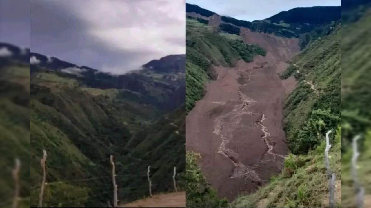
Before and after image of the landslide at El Molino in Colombia. Image from Semana.
.
It is very difficult to appreciate the scale of this landslide from photographs, but Noti Cucuta has tweeted this helicopter footage of the aftermath of the event:-
Grave desastre en Villa Caro deja cinco personas desaparecidas. pic.twitter.com/muIWVES8OK
— Noti Cúcuta (@noticucuta) November 12, 2022
.
There is also another video that has been tweeted by Diario La Opinión:-
#Atención #Video | En el sobrevuelo que hizo la Gobernación de Norte de Santander, se ve el estrago de la temporada invernal que afecta a los habitantes de Villa Caro.
Más info en: https://t.co/FGSSTs7IlP pic.twitter.com/KzSGRAJLeI— Diario La Opinión (@laopinion_col) November 11, 2022
.
And Segunda División del Ejército Nacional has a further helicopter video, which shows the long runout of the landslide:-
En horas de la tarde acompañamos a @GoberNorte y al equipo de gestión del riesgo, en un sobrevuelo sobre la zona afectada por la ola invernal en Villa Caro, para evidenciar la magnitud de lo ocurrido y apoyar a las autoridades en las labores humanitarias de emergencia. pic.twitter.com/um6KqRTUl5
— Segunda División del Ejército Nacional (@Ejercito_Div2) November 12, 2022
.
The landslide was triggered by prolonged heavy rainfall. It has resulted in 28 families being rendered homeless, and five people from a single family are reported to be missing, presumed to have been killed.
This landslide is quite reminiscent of the 16 December 2017 Villa Santa Lucia landslide in Chile. I will need to use satellite imagery to understand it properly. The landslide was captured on a Planet Labs image on 11 November 2022, so this will be possible in the coming days. The crown of the landslide is at 7.949, -73.025. It has a total runout distance (crown to toe) of about 5 km.
I will provide more details in the coming days.
 Dave Petley is the Vice-Chancellor of the University of Hull in the United Kingdom. His blog provides commentary and analysis of landslide events occurring worldwide, including the landslides themselves, latest research, and conferences and meetings.
Hi Dave, I would say the landslide crown is here : 7.946251, -73.029825 (can recognize the trail across the slope). Lot of existing gullies at the foot of the slope… with a big retrogression potential apparently !