
11 March 2021
The Tavernola landslide: a potential tsunami-inducing failure causing concern in Italy
The Tavernola landslide: a potential tsunami-inducing failure causing concern in Italy
This morning, loyal reader Stéphane Baize (@Stef_EQ_Geology) tweeted an Italian newspaper article about the Tavernola landslide on the banks of Lago d’Iseo in northern Italy. In recent days a large section of mountain has started to move at a significant rate, driving fears of a major slope collapse. The estimated volume of the resultant landslide ranges from 440,000 to 2.1 million m³. The slope is steep, suggesting that the mass could accelerate rapidly. Modelling indicates that in the worst case scenario the resultant tsunami could be large – wave heights of 9 metres above the current lake level are possible. The banks of the lake are densely populated, the list of settlements at risk includes Tavernola, Montisola, Marone, Sulzano, Iseo, Sale Marasino, Castro and Paratico.
The wave would hit Montisola within 30 seconds of the landslide entering the water. Tavernola would be struck a minute later.
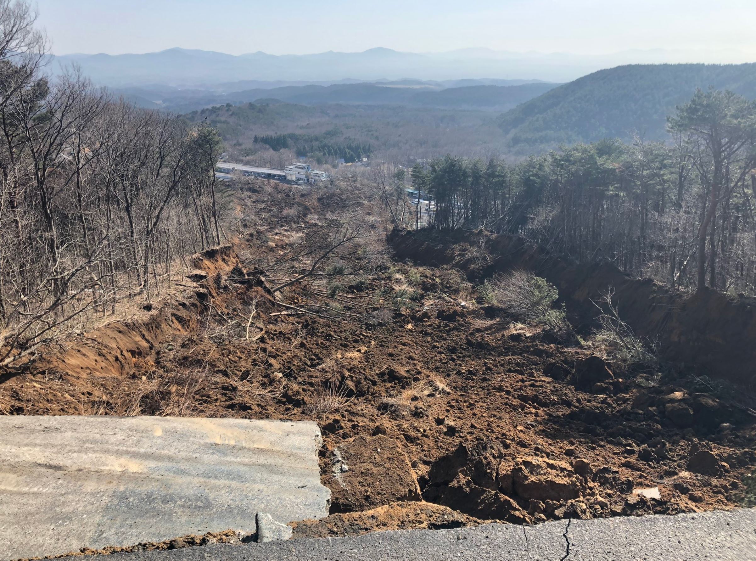
The newspaper L’Eco di Bergamo has an image of the site of the unstable slope:-
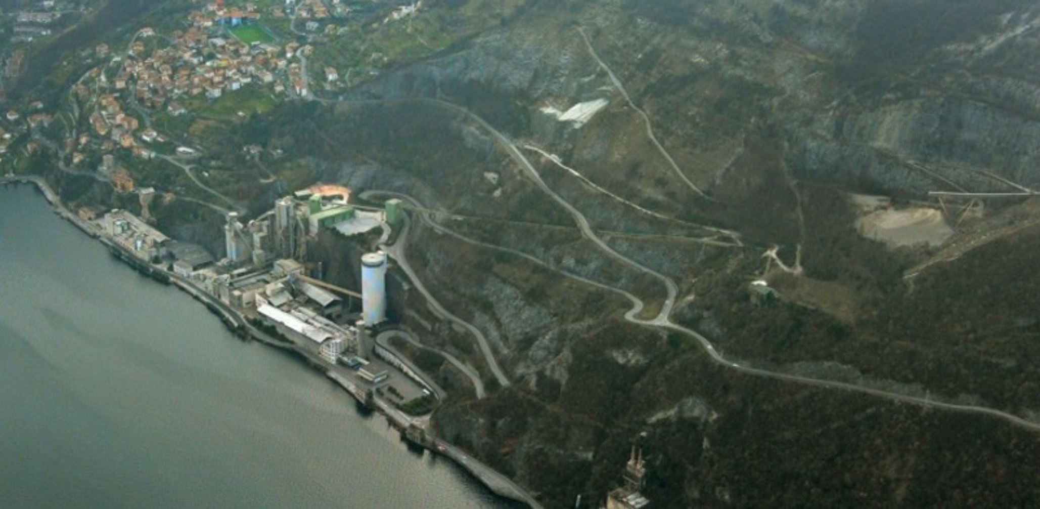
A panoramic view of the site of the Tavernola landslide in Italy. Image from L’Eco di Bergamo / San Marco.
.
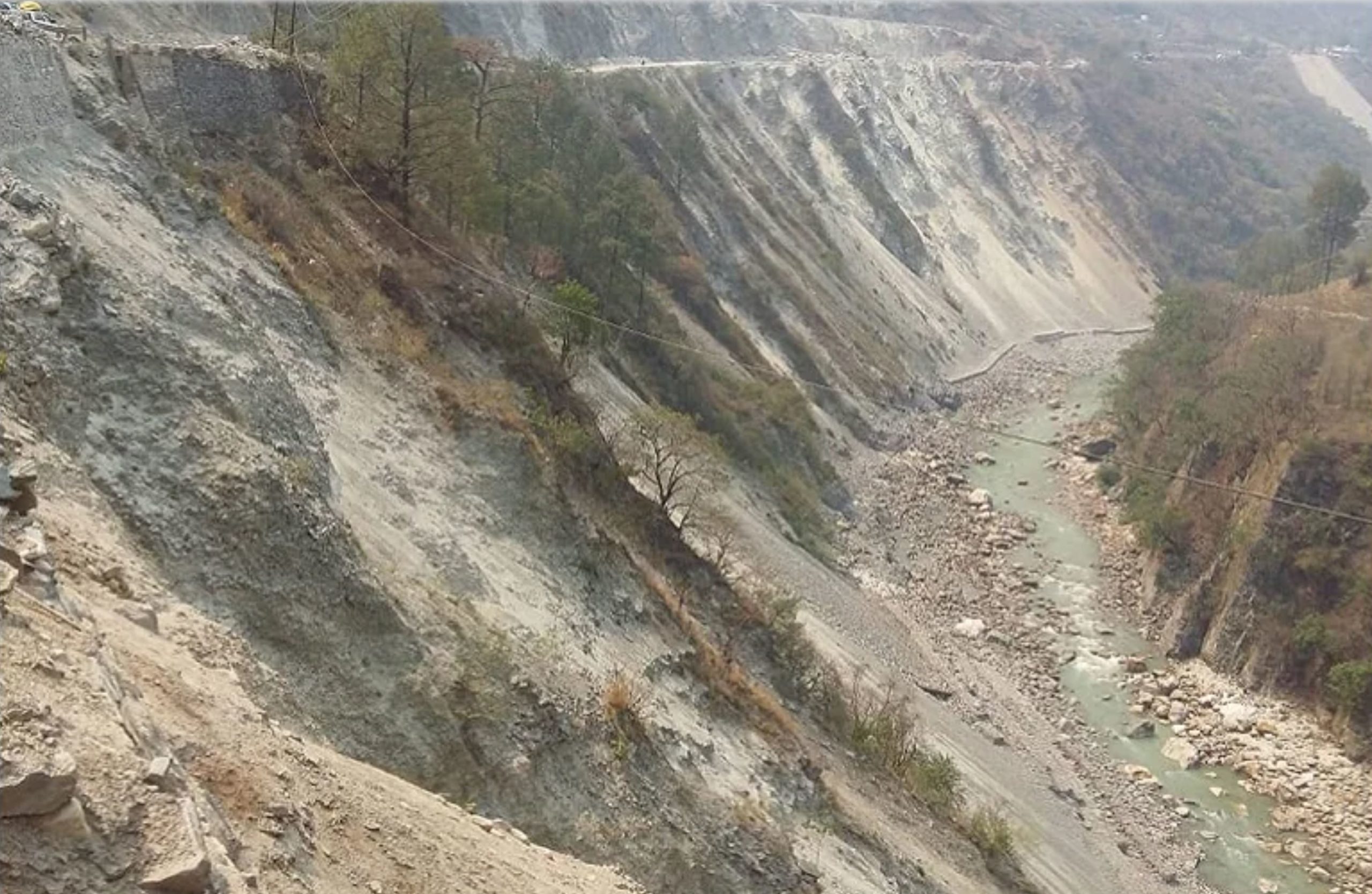
Meanwhile, Tutto Notizie has an image indicating the approximate location of the unstable mass:-
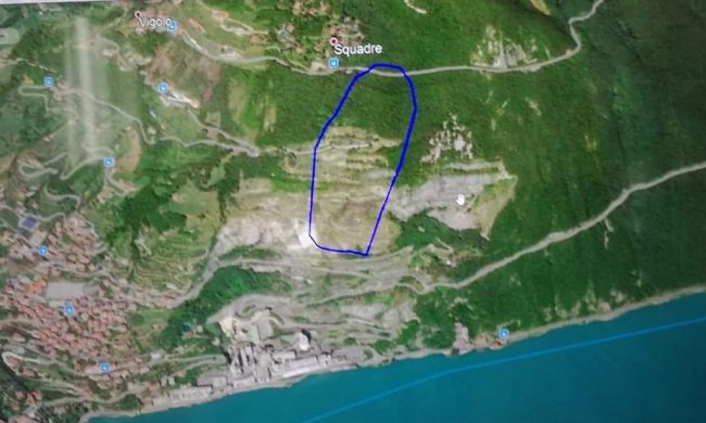
The approximate boundaries of the Tavernola landslide. Image from Tutto Notizie.
.
The outcome of this event will depend on a range of complex parameters, most of which are difficult to predict. Failure of the Tavernola landslide is not inevitable, and indeed there are signs that the landslide has slowed in recent hours. Those who followed the trials and tribulations of the Mannen landslide in Norway will understand how difficult it is to predict failure.
Second, the volume of rock that could fail is hard to estimate. This will be determined by the dynamics of the slide, the structure of the rock mass and the ability of the landslide to entrain material downslope.
Third, the failure sequence will be key. Will the Tavernola Landslide fail as a single block, or will there be multiple events? The resultant tsunami is very dependent on this component, but again it is difficult to predict.
In the meantime, the authorities have little choice but to manage the risk and to monitor the slope, hoping that the movement will stop. This will then provide time for a solution to be found.
Of course I am bound to note that this landslide is occurring on a slope that has been extensively quarried, and thus is likely to be a manmade event, at least in part.
10 March 2021
The evolution of landslides after the 2015 Mw 7.8 Gorkha, Nepal earthquake
The evolution of landslides after the 2015 Mw 7.8 Gorkha, Nepal earthquake
An ongoing area of discussion in landslide research is the evolution of slopes in the aftermath of earthquakes. it is well-established that large earthquakes in upland areas trigger large numbers of slope failures, in some cases casing extremely high levels of loss. It is also known that the first very heavy rainfall event after an earthquake in a mountainous area is often associated with further very high levels of landsliding – an issue that we highlighted in a paper in the aftermath of the 1999 Chi-Chi Earthquake in Taiwan (Lin et al. 2006).
Presumably after an earthquake the landscape should return to some sort of equilibrium, with the number of landslides active each year reducing with time, on average. But how quickly this occurs is poorly constrained. It might of course vary from place to place according to the climate, geology, vegetation and human activities. This is not a purely academic issue – this effect strongly determines the hazard posed by mountain communities after an earthquake.
In an open access paper just published in the journal Progress in Disaster Science (Rosser et al. 2021), a multidisciplinary team has examined this question with respect to the 2015 Mw 7.8 Gorkha, Nepal earthquake. They have focused on an area heavily affected by landslides in central and western Nepal. There is a great deal of richness in this paper, which also looks at risk management with mountain communities. However, in this post I will focus simply on the question of post-earthquake slope evolution.
The team has mapped landslides in a large study area on multiple occasions since the Gorkha Earthquake. In particular, they have manually mapped landslides twice per year since 2015, before and after the annual monsoon. The area chosen is a large swathe of west and central Nepal. This allows them to compile the following, critically important, diagram showing the trend in landslide occurrence in the landscape with time:-

Changes in mapped landslide numbers and total landslide area between 2014, the Gorkha earthquake in 2015, and post-monsoon 2019, from Rosser et al. (2021). Vertical blue bars show the timing of the monsoon; solid black line is landslide number; dashed black line is landslide area; and, the time of the earthquake (orange line) and the first local elections (green lines).
.
The jump in the number and area of landslides caused by the Gorkha Earthquake in 2015 is clear. As expected, this increases further in the monsoon that year. Interestingly, the number of landslides increased again slightly through the dry season in the winter of 2015-16, which is slightly surprising. After this there was a slow decline in the number of landslides, although this was a quite marginal change, much less than has been seen elsewhere.
Fascinatingly, the area and number of landslides increases markedly again from 2017 onwards, which is definitely unexpected. Rosser et al. (2021) suggest that this is due to a “proliferation of rural road construction around the time of the first local elections”. The number of landslides in the study area is now in excess of 21,000, more than on the day after the earthquake and after the first monsoon season.
I have highlighted ad nauseam the terrible costs of unconstrained rural road construction in high mountain areas. In the aftermath of the Gorkha Earthquake, Rosser et al. (2021) have demonstrated well that in central and western Nepal, rural roads are serving to amplify the impacts of the seismic shaking, and to extend them in time.
.
References
Lin, J-C, Petley, D.N., Jen, C-H., Hsu, M-L. 2006. Slope movements in a dynamic environment – A case study of Tachia river, Central Taiwan. Quaternary International, 147 (1), 103-112.
Rosser, N., Kincey, M., Oven, K. et al. 2021. Changing significance of landslide Hazard and risk after the 2015 Mw 7.8 Gorkha, Nepal earthquake, Progress in Disaster Science, 100159, https://doi.org/10.1016/j.pdisas.2021.100159.
9 March 2021
Ebisu Circuit: an intriguing landslide caused by the 2021 Fukushima Earthquake
Ebisu Circuit: an intriguing landslide caused by the 2021 Fukushima Earthquake
On 13 February 2021 the M=7.3 2021 Fukushima Earthquake (also known as the Fukushima-ken Oki (Fukushima Prefecture Offshore) earthquake) struck eastern Japan. This earthquake killed one person and injured around 185 people, and caused some structural damage and landslides.
The most interesting landslide occurred at Ebisu Circuit, a motor racing track located in the hills near to Nihonmatsu in Fukushima Prefecture. This landslide did not cause any loss of life but it has inflicted considerable damage to the track. The best overview image that I can find is this one, from Reuters:-
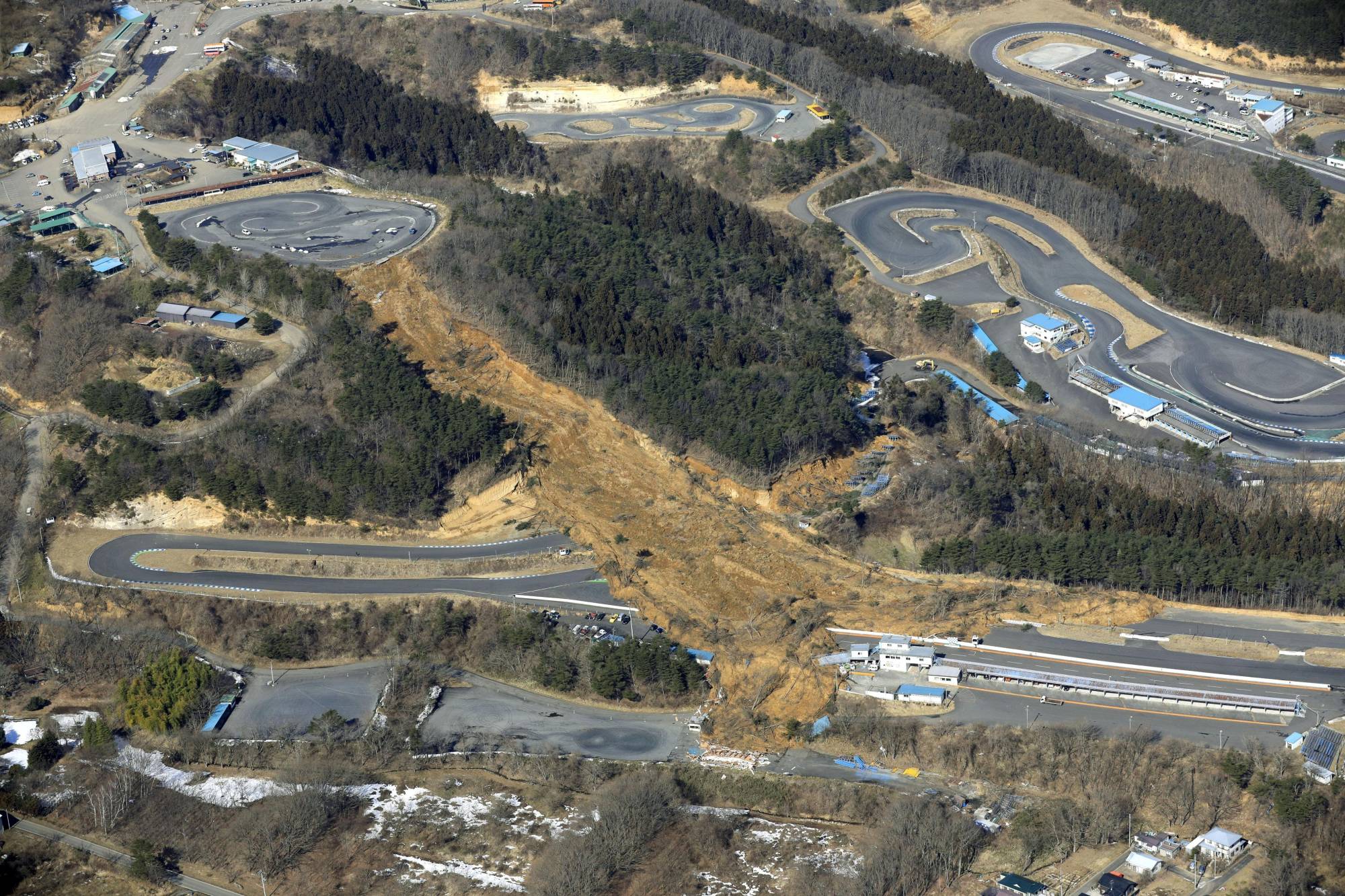
An aerial view of the landslide caused by a strong earthquake at the Ebisu Circuit in Nihonmatsu, Fukushima Prefecture, Japan on February 14, 2021 in this photo taken by Kyodo. Image:Kyodo/via REUTERS and The Japan Times.
.
Meanwhile, Sankei.com has an alternative view looking up the length of the length of the landslide:
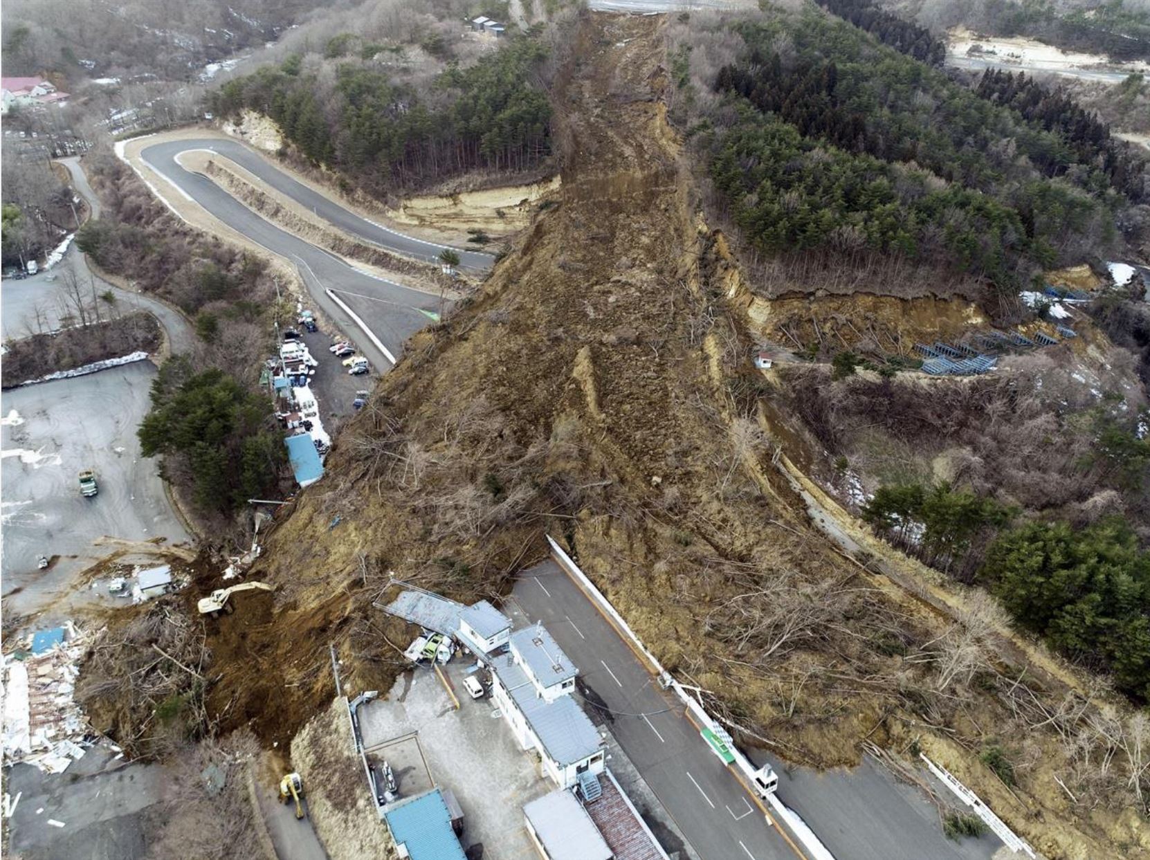
The track of the Ebisu Circuit landslide. Image from Sankei.com
.
On first inspection I assumed that this would be a fill slope failure associated with material emplaced to create the small circuit at the top of the slope. However, This image of the top of the slope, tweeted by @tarokote, suggests that this is not the case:
The crown of the slope failure at Ebisu Circuit. Image tweeted by @tarokote.
.
There is no evidence of a fill slope, and indeed the failure is shallow and slope parallel along its length – almost the epitome of an infinite slope failure. It is slightly deeper on the right side than on the left, which is an interesting feature.
There is a short article, in Japanese, about the geology of this failure, posted by the Geological Society of Japan. Google Translate suggests that it says (I have modified the language a little, and abridged it):-
Regarding the geology near this place, there is a wind formation layer of about 10 m containing many tephras originating from Adatara volcano that covers the surface layer. Below that are the early Pleistocene debris avalanche deposits (Fd) with a thickness of several meters to 10 meters, and below that are the rhyolite pyroclastic rocks and lava (M2r) of the Middle Miocene Iwakura Formation.
It is certain that at least the surface wind layer slipped down at the collapse of this point. It is necessary to wait for a field survey to find out where the slip surface is between the Iwakura Formation and the Fushiogami debris avalanche deposit, or in the pumice layer of the Fuse Formation, which contains many tephras.
It is known that similar surface collapses of the wind formation including the tephra layer occurred at three sites in Shirakawa City, Fukushima Prefecture during the 2011 Tohoku Taihei-oki Earthquake, resulting in 14 deaths and missing persons.
So, it appears that the landslide at Ebisu Circuit is a failure in a volcanic soil formed from tephra (volcanic materials such as ash). These materials appear to have formed a flow that has had a high level of mobility.
4 March 2021
The Char Dham Project: landslides associated with road widening in northern India
The Char Dham Project: landslides associated with road widening in northern India
The dreadful landslide disaster last month in northern India has served to highlight, very clearly, the threat posed by poor awareness of slope issues in the Hindu Kush Himalayas. Regular readers will be bored of my repeatedly making the point that we are failing to adequately consider, or manage, these threats across a range of human activities as development continues apace.
In Uttarakhand there is another very major infrastructure project, alongside the hydroelectric schemes that we so badly damaged on 7 February, that is also leading to substantial levels of loss. This is the Char Dham project, a road widening scheme of sufficient magnitude that it has its own Wikipedia entry:
Char Dham National Highway (Hindi: चार धाम महामार्ग), is an under construction two-lane (in each direction) express National Highway with a minimum width of 10 metres in the Indian state of Uttarakhand. The under construction highway will complement the under-construction Char Dham Railway by connecting the four holy places in Uttarakhand states namely Badrinath, Kedarnath, Gangotri and Yamunotri. The project includes 900 km national highways which will connect whole of Uttarakhand state.
I am not against the development of infrastructure in high mountain areas, indeed quite the opposite, but these zones are fragile. These roads have the potential to be a vital lifeline, but they also have the potential to create untold havoc. Unfortunately, there are growing concerns about the latter, caused by poor alignment selection, engineering design and construction practise. In particular, there is clear evidence that the road widening is causing slope instability on a grand scale. Reports suggest that data from the Ministry of Road Transport and Highways has indicated that there are at least 161 major slope failures along the alignment, with more expected due to poor construction practises and the removal of trees. Bizarrely, a committee of the Supreme Court in India that has been investigating the project appears to be split, releasing two reports, one of which favours continuing with a 10 m wide road bench, the other indicating that it should be narrowed to 7 m.
There is an interesting article on the environmental costs of the Char Dham project on the First Post website, which includes this horrifying picture:
Landslides on the Char Dham highway. Image taken on NH94 by Mallika Bhanot, posted online by First Post.
.
SANDRP also has a good article about this project.
Whilst the Char Dham project is undoubtedly important both strategically and in development terms, it is undeniable that the practises shown above are deeply problematic. Their legacy is likely to last for a long time.
2 March 2021
Ebian Yi Autonomous County: a dramatic rockslide caught on video in China
Ebian Yi Autonomous County: a dramatic rockslide caught on video in China
On 27 February 2021 a dramatic rockslide occurred in Ebian Yi Autonomous County in Sichuan Province, killing one person and injuring a further three. Unfortunately I cannot find a video of this event that I can embed, but both Newsflare have a version on its website.
The best commentary that I have found on this event comes from Teller Report, which has a translated version of a CCTV report:-
A huge boulder fell and destroyed many houses in Ebian, Sichuan. According to a report from the Propaganda Department of the Ebian Yi Autonomous County Party Committee of Leshan City: At about 16:50 on February 27, a rock-injury incident occurred in a group of Xinsheng Village, Shaping Town, Ebian County. The incident caused serious damage to 3 houses. One person was injured and one person was buried.
After the incident, the county party committee and the county government immediately launched an emergency response, mobilizing emergency, fire, medical rescue, and township emergency militia to search and rescue the buried people to eliminate possible surrounding risks.
At present, the injured have been treated in the hospital and their lives are not in danger for the time being. The surrounding people have been evacuated and resettled, and the social order is stable.
The cause of the incident is under investigation.
The videos appear to show a large amount of dust being generated high on the slope, and then a trail of dust down the hillside to the houses. It seems that a larger event was occurring at the top of the slope that released the boulders – a simple rockfall? quarrying? construction?
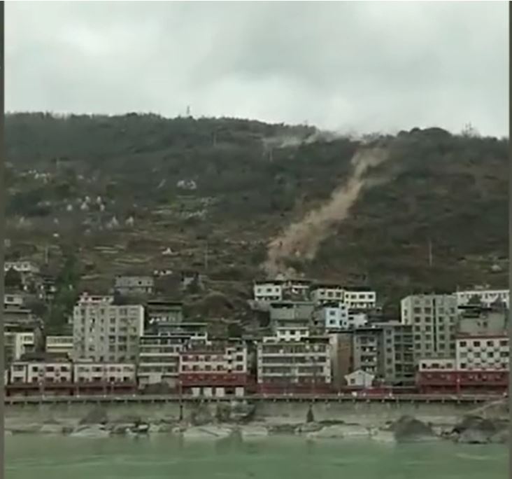
The 27 February 2021 landslide in Ebian Yi Autonomous County in China. Still from a video.
.
The Newsflare video shows the event from another angle:-
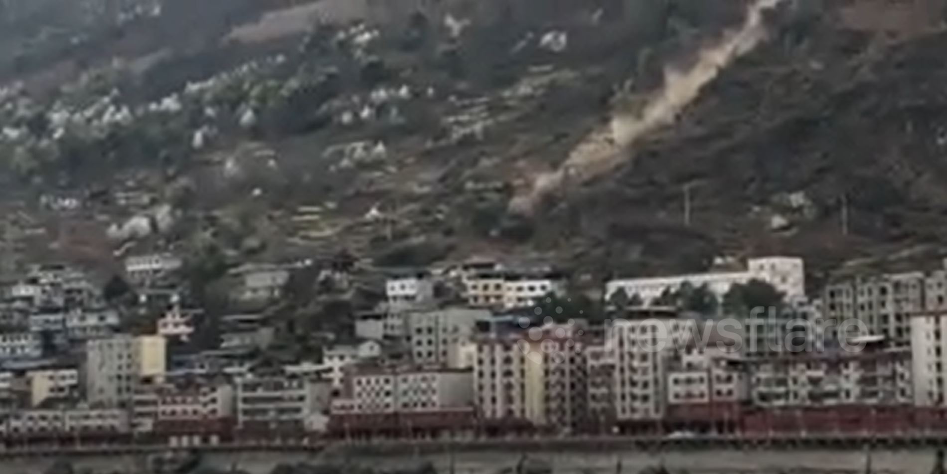
The 27 February 2021 landslide in Ebian Yi Autonomous County in China. Still from a video posted by Newsflare.
.
On first inspection, the location appears to be approximately where I have placed the marker on the map below. The image provides the latitude and longitude:
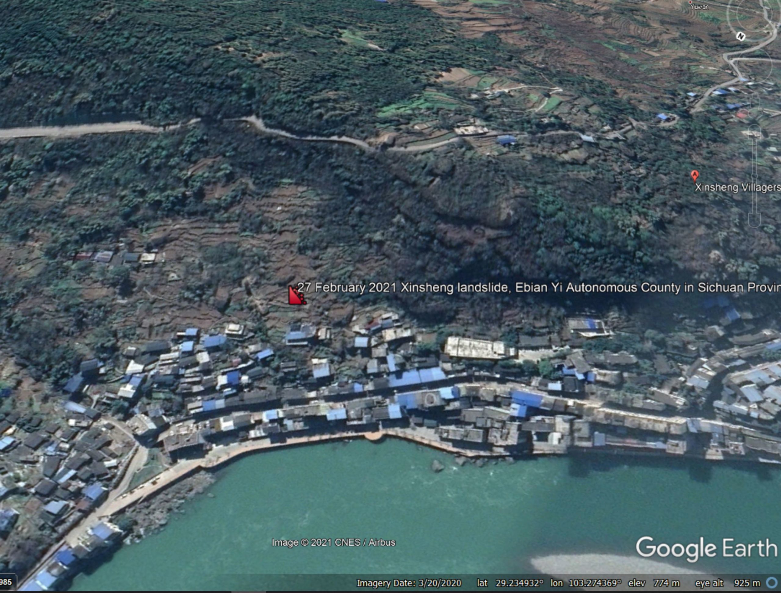
Google Earth image of the approximate location of the 27 February 2021 landslide in Ebian Yi Autonomous County in China.
1 March 2021
Staithes: an interesting place to pitch a tent for the weekend
Staithes: an interesting place to pitch a tent for the weekend
The UK is currently in a Covid-19 lockdown. It is illegal to stay away from home without due reason; all cafes, restaurants and bars are closed, as are non-essential shops. In general the population has responded well, and the statistics are all pointing in the right direction. The vaccine roll-out is a remarkable success – over 90% of the population aged 65 and over has now been vaccinated, as have most frontline health workers and those with medical conditions that render them particularly vulnerable. As I’m over 50, I can expect to receive a first dose by the middle of next month.
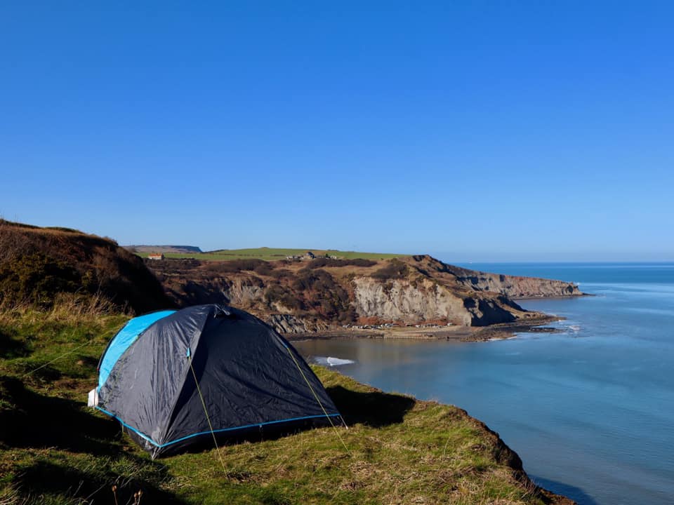
This is the context for a remarkable decision by a couple who, at the weekend, decided to take their child for spot of rough camping. Presumably wanting to get away from it all, they chose to pitch their tent at the top of the highest sea cliffs on the east of England near to Staithes in North Yorkshire. The Staithes Coastguard. posted images on their Facebook feed:-
The tent at the top of the cliff near to Staithes. Image posted to Facebook by the Staithes Coastguard.
.
No-one can deny that the campers chose a beautiful spot, and the weather this weekend was glorious:-
The location of the tent at the top of the cliff near to Staithes. Image posted to Facebook by the Staithes Coastguard.
.
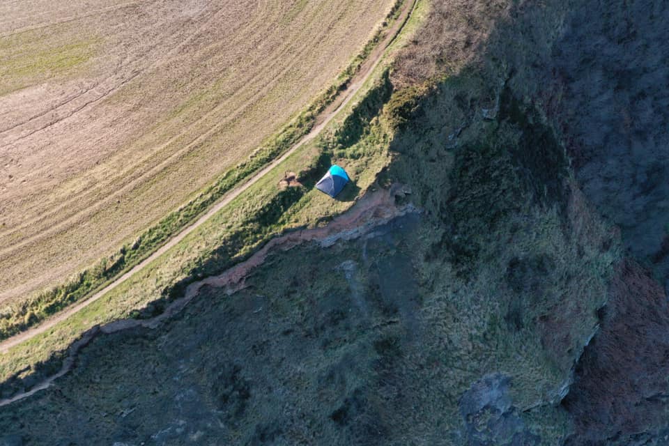
But at this site there is a long way to fall:-
View down on the tent at the top of the cliff near to Staithes. Image posted to Facebook by the Staithes Coastguard.
.
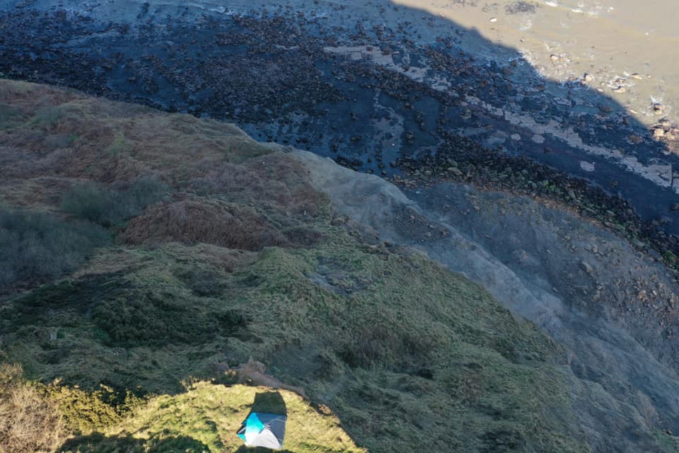
A Google Earth image of this area illustrates why this location was a poor choice:-
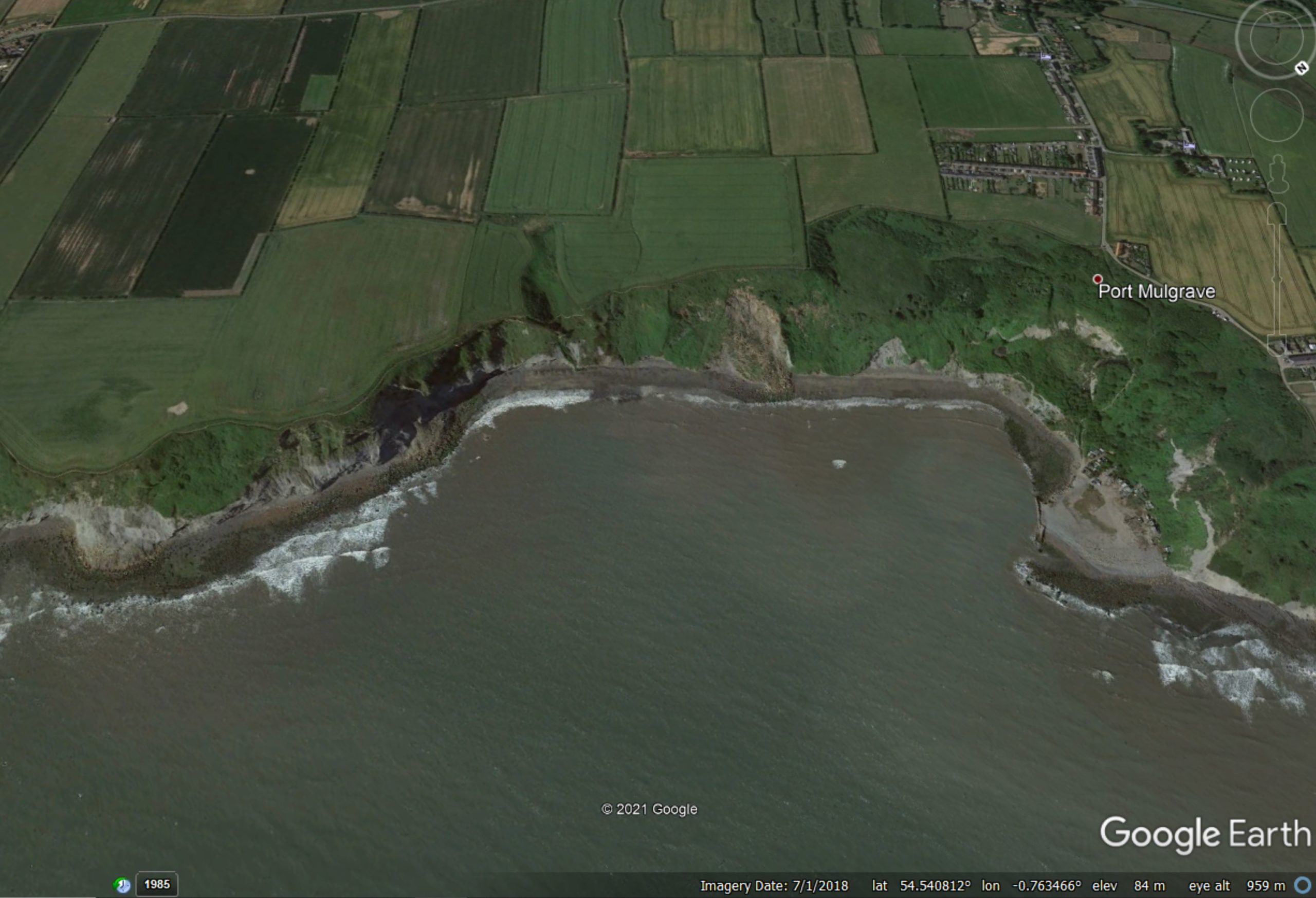
Google Earth image of the site of the tent near to Staithes.
.
The ditch between the tent and the fields is of course a tension crack for the block that is actively deforming. The tent has been pitched on the top of the landslide block. Landslides on this section of cliff are frequent and are sometimes fatal, sadly.
Overall, this was not a good plan.
26 February 2021
Badong, China: population relocation due to landslides associated with the Three Gorges Dam
Badong, China: population relocation due to landslides associated with the Three Gorges Dam
The Three Gorges Dam in China is without doubt one of the greatest feats of engineering. Lifting the level of the Yangtze River by 175 m, it created a reservoir that is 660 km long. The dam generates electricity, moderates floods and provides a navigable river for large ships, opening up central China for economic development.
Early in the project it was clear that landslides would be substantial hazard along the banks of the Three Gorges reservoir. It subsequently became clear that the magnitude of the hazard was substantially under-estimated, such that far more people would need to be relocated away from hazard zones. However, dispute the publication of case studies it has been difficult to determine the true impact of the landslides along the reservoir banks since the water level was raised over a decade ago.
A really interesting paper (Gong et al. 2021) has just been published in the journal Engineering Geology – this paper is open access – which explores this issue. It focuses on Badong, a county within the Three Gorges area, whose county seat has been relocated on three occasions due to landslides. The graphic below, from the paper, illustrates the series of events:
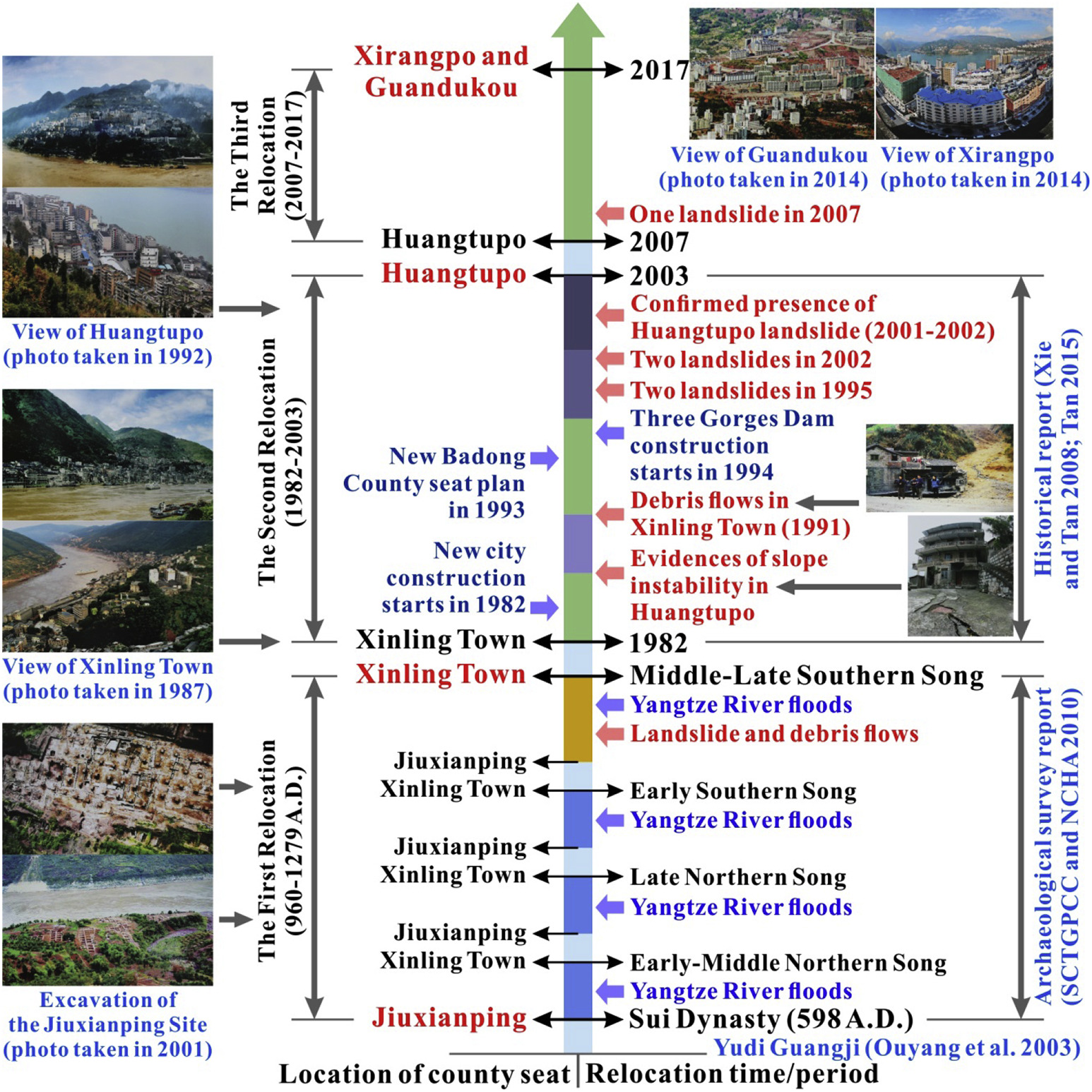
The sequence of events that led to the relocation of the county seat of Badong as a result of landslides in the Three Gorges area. Figure from Gong et al. (2021).
.
The original site of the county town of Bandong, Jiuxianping, was located on the northern bank of the Yangtze River. It was subject to repeated flood events, causing some relocations to occur, but in the Middle-Late Southern Song period it was moved to Xinling Town on the southern bank, probably because of a major debris flow.
However, Xinling town was close to the level of the river, and thus became unviable with the elevation of the water level associated with Three Gorges Dam. Xinling was also subject to problems with landslides. Thus, between 1982 and 2003 a plan was developed to relocate the population of Xinling to Huangtupo. The image below shows the locations of the various towns in the paper:-
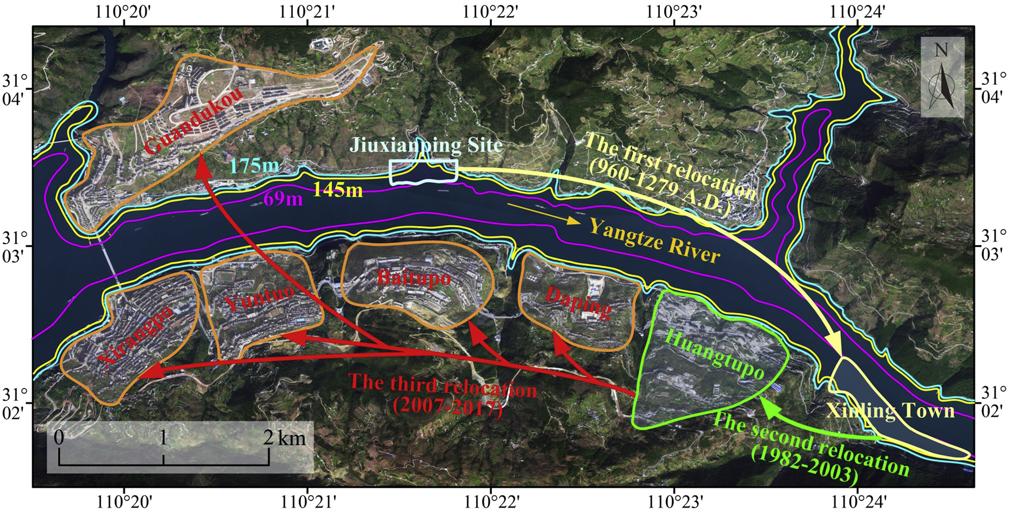
The various sites of the County town of Badong. Figure from Gong et al. (2021).
.
Unfortunately, Huangtupo proved to be a problematic site. Shortly after construction started in 1982, evidence of slope instability instability emerged. A site investigation in 1988 identified two large ancient landslides. On 6 August 1991 large debris flows occurred in the area, triggered by an intense storm. These debris flows destroyed the southern part of Xinling, killing three people and injuring a further 171 individuals.
In 1995, two landslides further landslides occurred in Huangtupo, killing five people and causing substantial levels of economic loss. As the lake level rose further landslides were reported. In consequence, a decision was made to relocate the county town of Badong once again, this time to Xirangpo and Guandukou. Between 2007 and 2017 , over 15,000 people were relocated. Most of the buildings on the landslide complex at Huangtupo were demolished.
This paper provides a fascinating insight into both the landslides and the population relocations associated with the Three Gorges Dam programme. The underlying susceptibility of this area to landslides is well-illustrated by Gong et al. (2021). I have repeatedly noted on this blog that many landslide problems associated with hydroelectric dam projects come from a failure to identify existing ancient landslides in the landscape – a failure of the ground investigation phase of the project. This is the case here; the site of Huangtupo was underlain by a landslide complex with a volume of 69.2 million m³. It is unsurprising that this complex was reactivated when the reservoir level was raised.
.
Reference
Gong, W., Juang, H. and Wasowski, J. 2021. Geohazards and human settlements: Lessons learned from multiple relocation events in Badong, China – Engineering geologist’s perspective. Engineering Geology, https://doi.org/10.1016/j.enggeo.2021.106051.
25 February 2021
Landslides and sustainable development: managing the cost of landslides in less developed countries
Landslides and sustainable development: managing the cost of landslides in less developed countries
Yesterday, I was honoured to be able to present on of the keynote lectures at the XIII International Symposium on Landslides. This event was meant to have been held last year in Colombia. Unfortunately, it had to be postponed for obvious reasons. The hope had been to hold it this week, again in Colombia, but once again this was stymied by the wretched virus. In consequence, the event has been held online this week.
I have to give my thanks to the organisers, The Colombian Geotechnical Society, who have done a fine job in arranging a good meeting. I have been able to attend all of the keynote sessions so far, and many of the other sessions. The range and quality of the work being undertaken across the world is impressive, especially by early career researchers. Our discipline is in good hands.
I was asked by the organisers to speak for about 45 minutes on the topic of Landslides and sustainable development: managing the cost of landslides in less developed countries. This is a vast topic, in many ways too large to cover in a short lecture, so I decided to focus on three key themes – hydroelectric dams, mineral extraction and rural roads. I tried to present the problem and to highlight some solutions.
I have uploaded the presentation onto slideshare. WordPress no longer seems to permit an embed, so you should be able to view them here:-
.
You should also be able to download the file from slideshare, and I have put them on my Google Drive.
One of the issues I have tried to highlight is the high landslide incidence associated with rural (mountain) roads. The slide below is my interpretation as to why so-called “dozer roads” cause such high levels of loss from landslides:
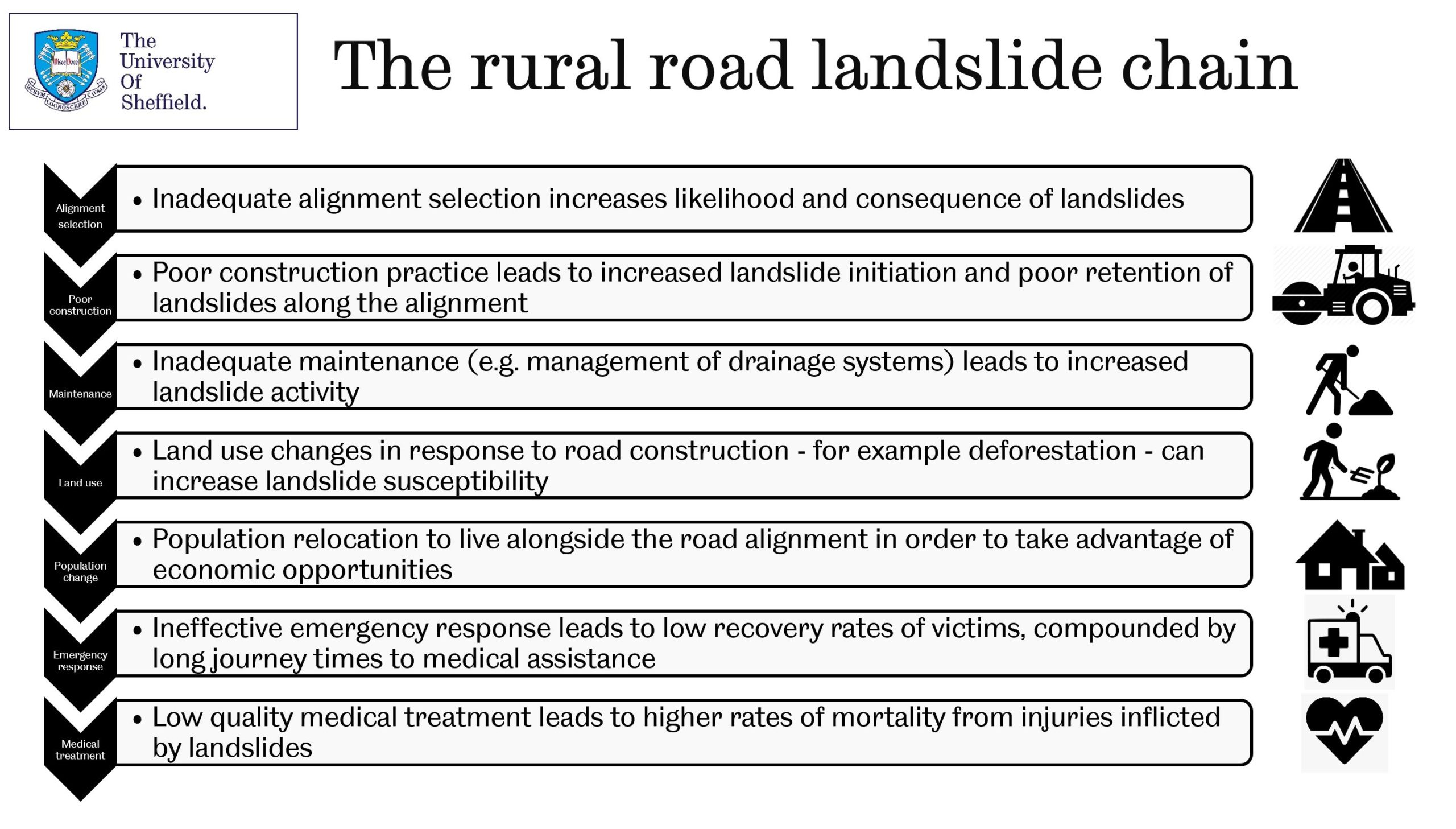
Landslides and sustainable development: the rural road landslide chain.
.
As noted above, I have tried to highlight principles for addressing these problems. The slide below illustrates some of my thoughts on how to manage rural roads properly:
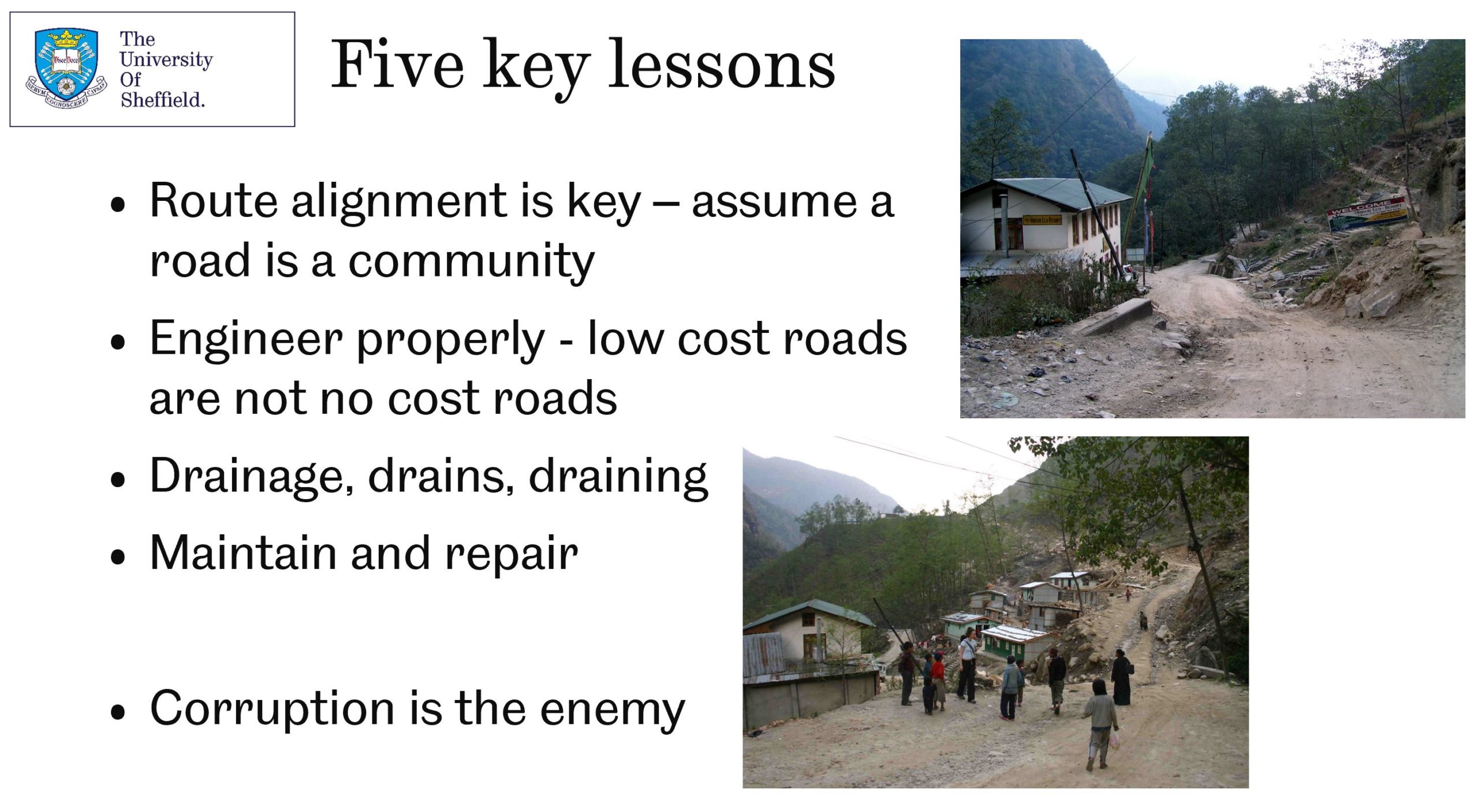
Landslides and sustainable development: managing mountain roads.
.
I very much doubt that my presentation is in any way the final word on these important topics, but I really hope it is of some use. Please feel free to use it as you see fit, but I would be grateful if you would acknowledge me, and refer to the open access paper (download it for free):-
Petley, D.N. 2021. Landslides and sustainable development: managing the cost of landslides in less developed countries. Keynote paper published in the Proceedings of the SCG-XIII International Symposium on Landslides. Cartagena, Colombia. Download from: https://www.issmge.org/uploads/publications/105/106/ISL2020-172.pdf.
23 February 2021
Camogli, Italy: the unfortunate impact of a landslide in a cemetery
Camogli, Italy: the unfortunate impact of a landslide in a cemetery
On 22 February 2021 a large coastal landslide occurred in the town of Camogli, near to Genoa in northwest Italy. In common with so much of Italy, Camogli is a historic town; thus, an urban landslide almost inevitably damages the historic fabric. In this case the landslide affected a large urban cemetery, which led to over 200 coffins falling into the sea. Fortunately no-one was injured.
An Italian fire brigade helicopter captured some images of the site. The image below shows the aftermath of the landslide:-
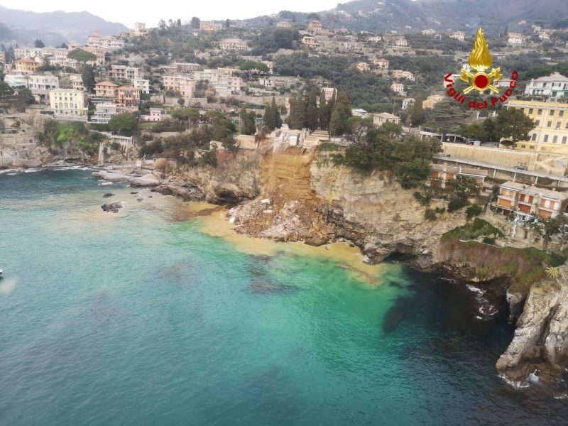
The landslide at Camogli in Italy. Image collected from an Italian fire brigade helicopter.
.
This appears to be a large rockfall on a near-vertical coastal slope, and it seems likely that there is undercutting by the sea. The image below is the Google Earth view of the site:-
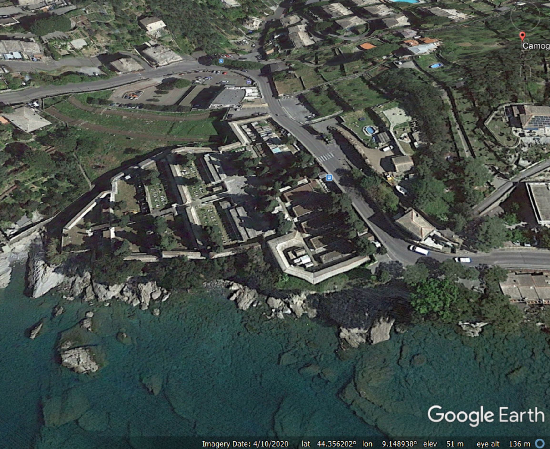
Google Earth image of the site of the landslide at Camogli
.
The Italian Fire Brigade helicopter also captured the aftermath, with the remains of over 200 coffins floating in the sea, many having been damaged:-
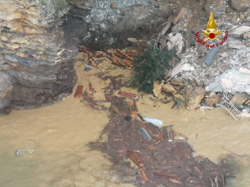
The aftermath of the landslide at Camogli in Italy. Image collected from an Italian fire brigade helicopter.
.
Clearly this is a deeply unfortunate incident that will have been very distressing for all involved. News reports suggest that the slope at Camogli had started to suffer from instability problems after a major storm in 2018. Works to mitigate the instability on parts of the cliff were ongoing, with scaling and vegetation removal, prior to the installation of a reinforcing mesh. Works were being undertaken at the time, such that workers at the site had to escape. However, the reports suggest that the actual section of cliff that collapsed may not have been subject to these works.
Efforts are now underway to retrieve the coffins and the remains.
22 February 2021
The valley blocking landslide at Rishi Ganga created by the Chamoli landslide
The valley blocking landslide at Rishi Ganga created by the Chamoli landslide
The recovery operations in the Tapovan area of Chamoli continue. As of yesterday, the remains of 68 people had been recovered, with another 135 still missing. Operations continue in the tunnel, where more victims are thought to be located, but conditions are clearly extremely challenging. Meanwhile, there is some interest in a valley blocking landslide that has been formed on the Rishi Ganga river by the landslide.
In the last few days an Indian Air Force helicopter winched navy divers onto the dam so that they could check the depth of the water. This was determined to be 8 to 9 metres, giving the lake a reported volume of 50,000 cubic metres. [edit] Note however that other reports indicate that the depth of the lake may be 60 metres. This report indicates that it is “400 metres in length, 25 metres wide and 60 metres deep”. If so this would give a much higher volume.
Planet Labs has managed to capture some high quality satellite images of this lake. The image below provides a really good, oblique view onto the landslide dam:-
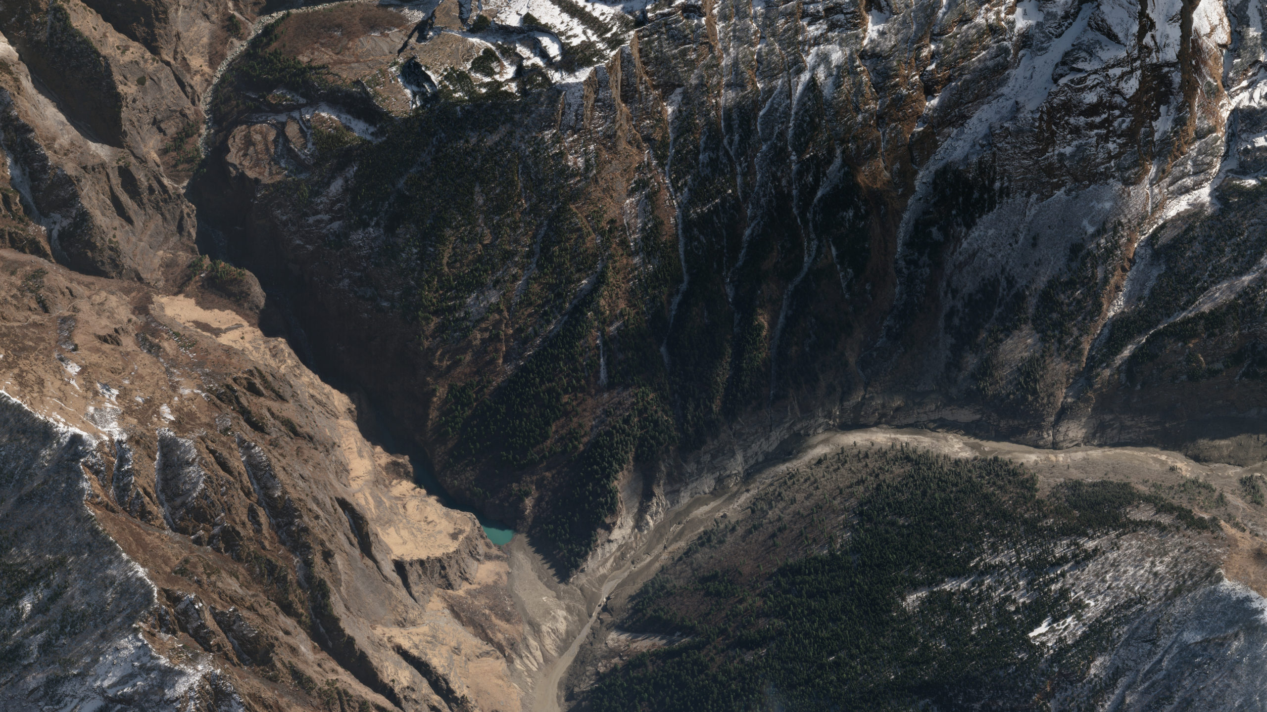
A perspective view of the landslide dam on the Rishi Ganga. Image copyright of Planet Labs, used with permission
.
The debris flow came from the right of the image, following the main channel to exit at the bottom of the image. The dam is left of centre, with the lake just visible.
Below is a more detailed view of the dam itself:-
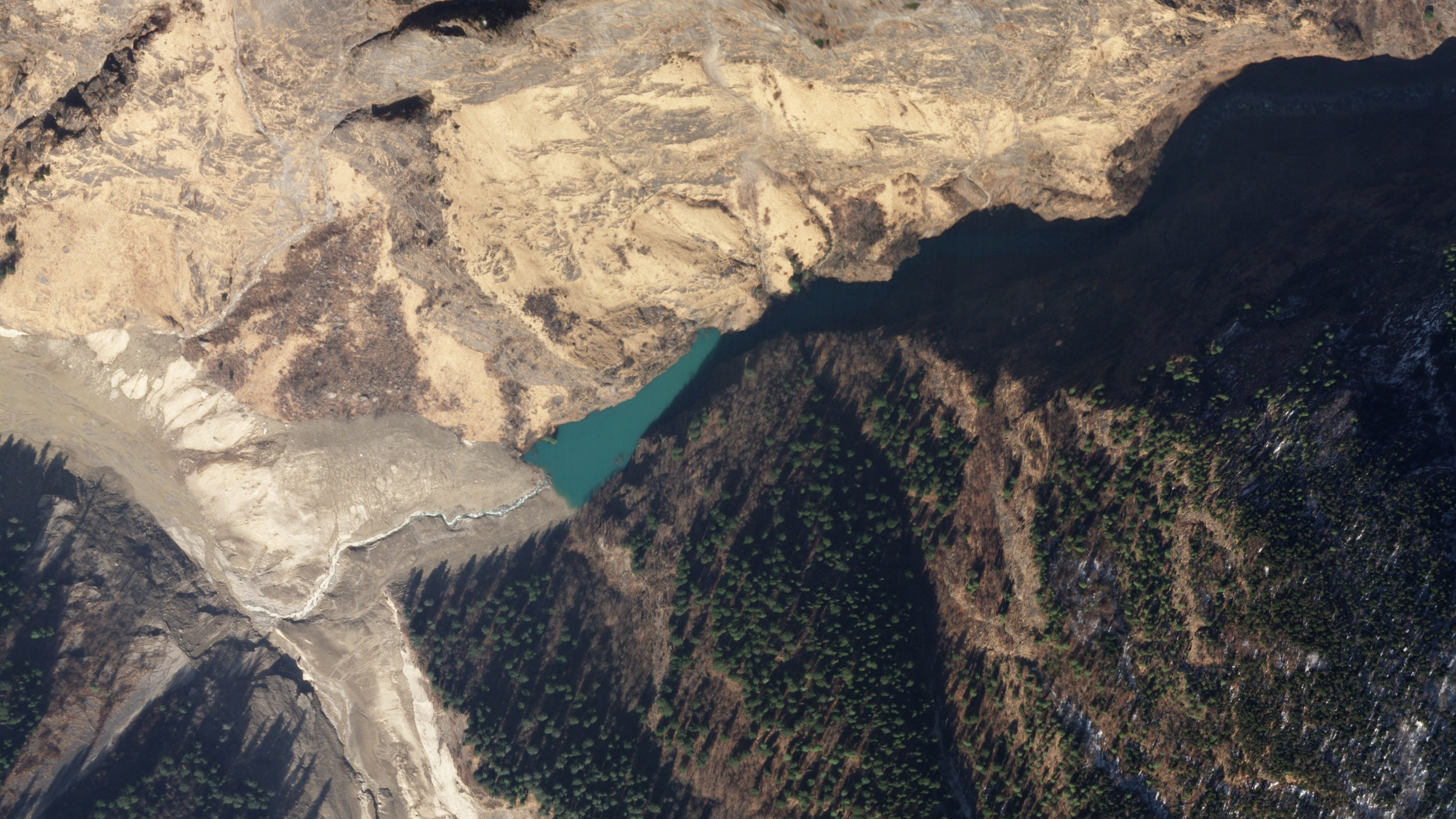
A perspective view of the landslide dam on the Rishi Ganga. Image copyright of Planet Labs, used with permission.
.
The good news is that there is a well-developed channel draining the lake, which has a modest volume. The risk downstream should not be ignored, but this does not pose the sort of threat that we saw at, for example, Attabad.
These images tell us something about the flow. I remain a little perplexed by the ongoing discussion about the source of the water in the flow, which seems to ignore the well-known observation that granular flows can occur with little or no water present. Large, dry granular flows give the appearance of having water present,even where they are dry, but they do generate considerable volumes of dust (as was the case here). Where they sweep down the valley, the front may become saturated as water is incorporated.
I am not arguing that the events on the Rishi Ganga were completely dry – they were not – but I do not think that we need to find a source for very large quantities of water. There was enough water present in the form of ice on the block that failed, and in the valley in the form of dead ice, snow and saturated sediments to explain the flow, in my view.
By the time the landslide reached the point shown above it was well-contained within the channel, as demonstrated by the intact trees on either side. There is some evidence of super-elevation on the outside of the bend. The landslide has dumped a large volume of sediment in this valley, which has been retained. The latter part of the flow appears to have eroded the toe.
I would be interested in the views of sedimentologists as to what the presence of this dam tells us about the characteristics of the flow. Comments?
.
Reference
Planet Team (2021). Planet Application Program Interface: In Space for Life on Earth. San Francisco, CA. https://www.planet.com/
 Dave Petley is the Vice-Chancellor of the University of Hull in the United Kingdom. His blog provides commentary and analysis of landslide events occurring worldwide, including the landslides themselves, latest research, and conferences and meetings.
Recent Comments