
9 March 2021
Ebisu Circuit: an intriguing landslide caused by the 2021 Fukushima Earthquake
Posted by Dave Petley
Ebisu Circuit: an intriguing landslide caused by the 2021 Fukushima Earthquake
On 13 February 2021 the M=7.3 2021 Fukushima Earthquake (also known as the Fukushima-ken Oki (Fukushima Prefecture Offshore) earthquake) struck eastern Japan. This earthquake killed one person and injured around 185 people, and caused some structural damage and landslides.
The most interesting landslide occurred at Ebisu Circuit, a motor racing track located in the hills near to Nihonmatsu in Fukushima Prefecture. This landslide did not cause any loss of life but it has inflicted considerable damage to the track. The best overview image that I can find is this one, from Reuters:-
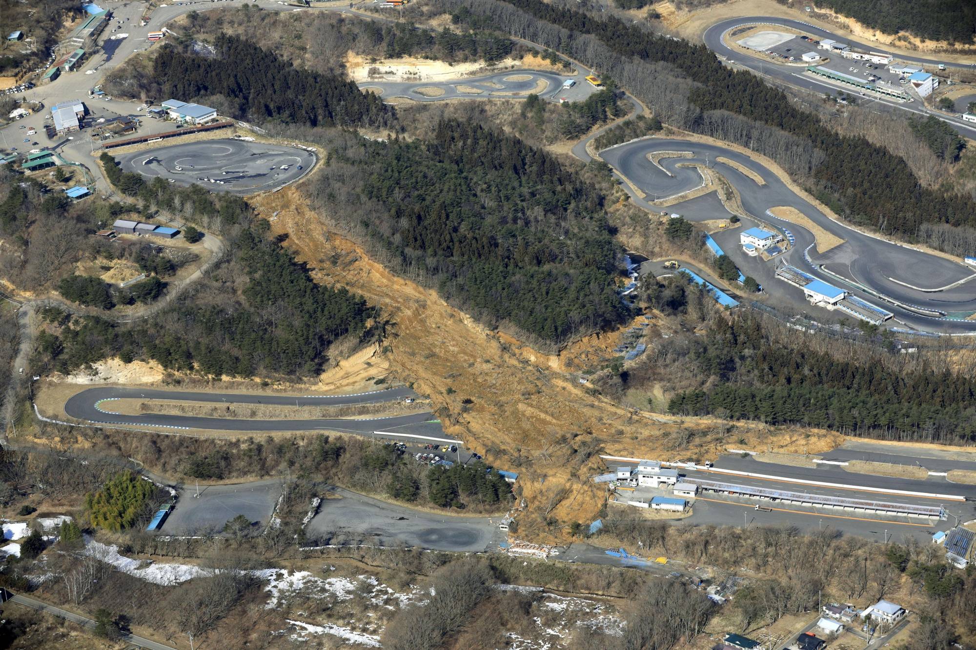
An aerial view of the landslide caused by a strong earthquake at the Ebisu Circuit in Nihonmatsu, Fukushima Prefecture, Japan on February 14, 2021 in this photo taken by Kyodo. Image:Kyodo/via REUTERS and The Japan Times.
.
Meanwhile, Sankei.com has an alternative view looking up the length of the length of the landslide:
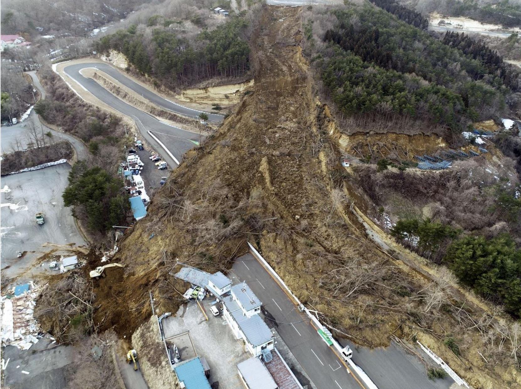
The track of the Ebisu Circuit landslide. Image from Sankei.com
.
On first inspection I assumed that this would be a fill slope failure associated with material emplaced to create the small circuit at the top of the slope. However, This image of the top of the slope, tweeted by @tarokote, suggests that this is not the case:
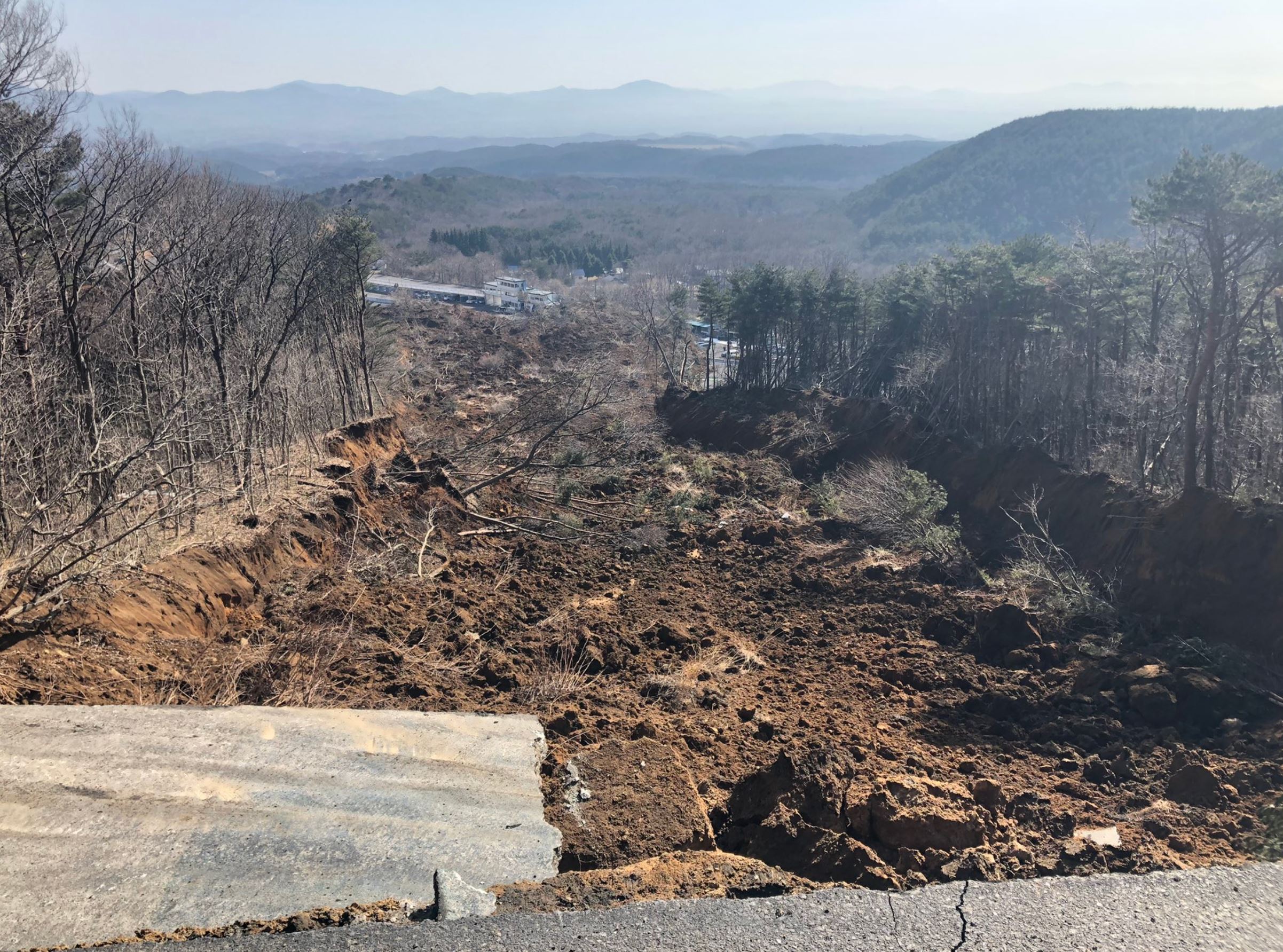
The crown of the slope failure at Ebisu Circuit. Image tweeted by @tarokote.
.
There is no evidence of a fill slope, and indeed the failure is shallow and slope parallel along its length – almost the epitome of an infinite slope failure. It is slightly deeper on the right side than on the left, which is an interesting feature.
There is a short article, in Japanese, about the geology of this failure, posted by the Geological Society of Japan. Google Translate suggests that it says (I have modified the language a little, and abridged it):-
Regarding the geology near this place, there is a wind formation layer of about 10 m containing many tephras originating from Adatara volcano that covers the surface layer. Below that are the early Pleistocene debris avalanche deposits (Fd) with a thickness of several meters to 10 meters, and below that are the rhyolite pyroclastic rocks and lava (M2r) of the Middle Miocene Iwakura Formation.
It is certain that at least the surface wind layer slipped down at the collapse of this point. It is necessary to wait for a field survey to find out where the slip surface is between the Iwakura Formation and the Fushiogami debris avalanche deposit, or in the pumice layer of the Fuse Formation, which contains many tephras.
It is known that similar surface collapses of the wind formation including the tephra layer occurred at three sites in Shirakawa City, Fukushima Prefecture during the 2011 Tohoku Taihei-oki Earthquake, resulting in 14 deaths and missing persons.
So, it appears that the landslide at Ebisu Circuit is a failure in a volcanic soil formed from tephra (volcanic materials such as ash). These materials appear to have formed a flow that has had a high level of mobility.
 Dave Petley is the Vice-Chancellor of the University of Hull in the United Kingdom. His blog provides commentary and analysis of landslide events occurring worldwide, including the landslides themselves, latest research, and conferences and meetings.
Is it my imagination, or can you see the two lines of failure witihn the trees on Google Earth (especially in 3D)? They both go from bottom to top of the slope and appear close to the limits of the slip.
There’s a cool blog post about the volcanoes that generated those tephras and the hazards of massive landslides in the area: https://www.volcanocafe.org/fukushima-in-two-volcanoes/
Interesting! The long runout distance may have similarities to landslide mechanisms in our tephra dominant soils in NZ.
In NZ, these tephra dominated soils occur at varying degrees of weathering, from fresh pumice, to highly weathered clay. We have found the long runout distance in the highly weathered tephra derived clay to be a function of the sensitivity of the materials. Sensitivity is attributed to the development of different morphologies of clay minerals, namely hydrated halloysite, as well as high water content, and low permeability. See our work on these tephra soils here:
https://www.researchgate.net/profile/Max-Kluger