
25 April 2017
The 2015 Gorkha earthquake in Nepal: two years on
Posted by Dave Petley
The 2015 Gorkha earthquake in Nepal: two years on
Today is the second anniversary of the 2015 Gorkha earthquake in Nepal, which killed almost 9000 people and set back the development of the country significantly. Kunda Dixit has written a nice piece in the Nepali Times about the disaster. He concludes that:
And speaking of funds, Nepal has actually received less than a third of the $9.38 billion the NRA estimated it needed to rebuild homes, public buildings and infrastructure. Of the $4.1 billion pledged by donors in 2015, only $2.73 billion has actually materialised (most of it in loans). This is not even enough for the housing grant of Rs 300,000 per family, which itself is inadequate to rebuild. The National Reconstruction Authority has come up with a new affordable design, but there seems little interest.
The main takeaway on the second anniversary is: International help has fallen far short of pledges and is much less than the amount actually needed, a lot of it is not going through the National Reconstruction Authority, and (as in other spheres of development) the government has failed in coordination.
This is of course a depressing story; one can only imagine what would have happened had the earthquake fulfilled its potential in terms of damage and loss. Worst is yet to come in a future earthquake; we know not when. There is an urgent need to prepare.
Of course one of the most significant impacts of the earthquake was the landsliding, especially in the north of the area of the fault rupture zone. I have highlighted previously that the number of landslides was far lower than we had anticipated might be the case. This is investigated by a paper recently published in the Journal of Earth Science by Xu et al. (2016). This paper, which is open access, compares the landslide distributions of the 2008 Wenchuan earthquake and the 2015 Gorkha earthquake. Although similar in size, the landslide impact was vastly different. For example, Xu et al. (2016) note that the 2008 Wenchuan earthquake generated 25,580 large landslides over an area of 44,000 square kilometres, whereas the 2015 Gorkha earthquake generated 2,064 large landslides over an area 35,600 square kilometres. That is an order of magnitude difference. This is illustrated beautifully by the landslide inventory maps for the two events:
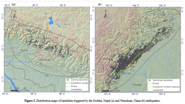
Inventory maps for the Gorkha and Wenchuan earthquakes, from Xu et al. (2016)
.
Most interestingly, Xu et al. (2016) try to understand the difference, and in particular why the 2015 Gorkha earthqake appears to have been relatively inefficient in generating landslides. Interestingly, they find that the key issue was not topography nor peak ground acceleration – in both cases the Wenchuan earthquake generated far more landslides than did the Gorkha earthquake for any given slope angle or peak ground acceleration value. Xu et al. (2016) note that:
The landslide numbers and density related to the Wenchuan Earthquake are much higher than those of the Gorkha Earthquake in any combinations of slope angle and PGA. Both slope steepness and PGA cannot explain the low number of Gorkha earthquake-triggered landslides.
They ascribe the difference to the angle of the fault that generated the earthquake. In the case of the 2015 Gorkha earthquake, the fault dips at about 10 degrees, whereas for the 2008 Wenchuan earthquake it dips at about 40 degrees. Xu et al. (2016) suggest that this is important because it causes a different level of deformation in the hanging wall block, and because it causes a different pattern of peak ground acceleration. In particular, as they put it:
Because the Wenchuan Earthquake occurred along a high-angle reverse fault, the area of the surface directly overlying the fault surface was relatively small, concentrating the surface energy and resulting in many large, intense landslides. In contrast, the Gorkha Earthquake occurred along a low-angle fault, so the overlying surface area was wide, the surface energy less concentrated, and fewer smaller landslides were triggered. In short, we suggest that that these two effects determine the capability of an earthquake to trigger landslides because the dip angle of the seismogenic fault controls the manner of earthquake energy release, and thus influences the deformation of the hanging wall bedrock.
I think this conclusion is of vital importance if we are to understand the potential distribution of landslides from future earthquakes. It will be fascinating to see how the landslide distribution maps out for the 2016 Kaikoura earthquake in this context.
Reference
Xu, C., Xu, X., Tian, Y. et al. 2016. Two comparable earthquakes produced greatly different coseismic landslides: The 2015 Gorkha, Nepal and 2008 Wenchuan, China events Journal of Earth Science 27: 1008-1015.
 Dave Petley is the Vice-Chancellor of the University of Hull in the United Kingdom. His blog provides commentary and analysis of landslide events occurring worldwide, including the landslides themselves, latest research, and conferences and meetings.