
22 February 2021
The valley blocking landslide at Rishi Ganga created by the Chamoli landslide
Posted by Dave Petley
The valley blocking landslide at Rishi Ganga created by the Chamoli landslide
The recovery operations in the Tapovan area of Chamoli continue. As of yesterday, the remains of 68 people had been recovered, with another 135 still missing. Operations continue in the tunnel, where more victims are thought to be located, but conditions are clearly extremely challenging. Meanwhile, there is some interest in a valley blocking landslide that has been formed on the Rishi Ganga river by the landslide.
In the last few days an Indian Air Force helicopter winched navy divers onto the dam so that they could check the depth of the water. This was determined to be 8 to 9 metres, giving the lake a reported volume of 50,000 cubic metres. [edit] Note however that other reports indicate that the depth of the lake may be 60 metres. This report indicates that it is “400 metres in length, 25 metres wide and 60 metres deep”. If so this would give a much higher volume.
Planet Labs has managed to capture some high quality satellite images of this lake. The image below provides a really good, oblique view onto the landslide dam:-
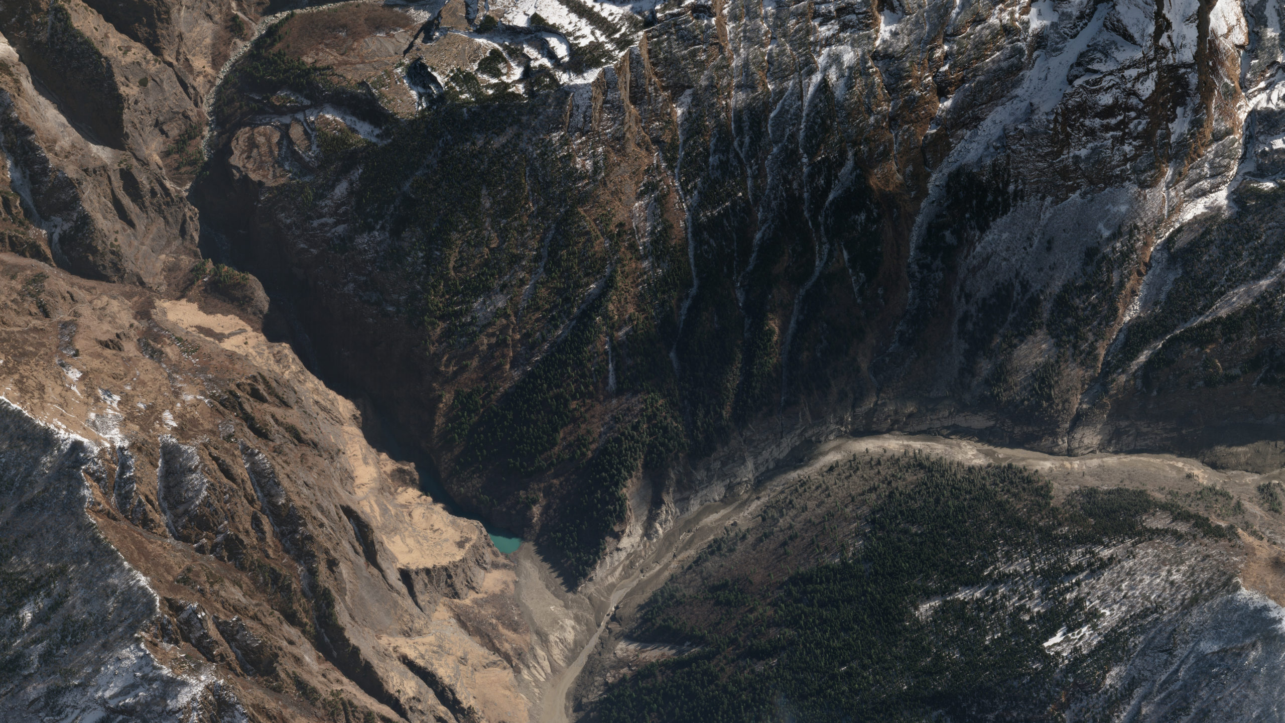
A perspective view of the landslide dam on the Rishi Ganga. Image copyright of Planet Labs, used with permission
.
The debris flow came from the right of the image, following the main channel to exit at the bottom of the image. The dam is left of centre, with the lake just visible.
Below is a more detailed view of the dam itself:-
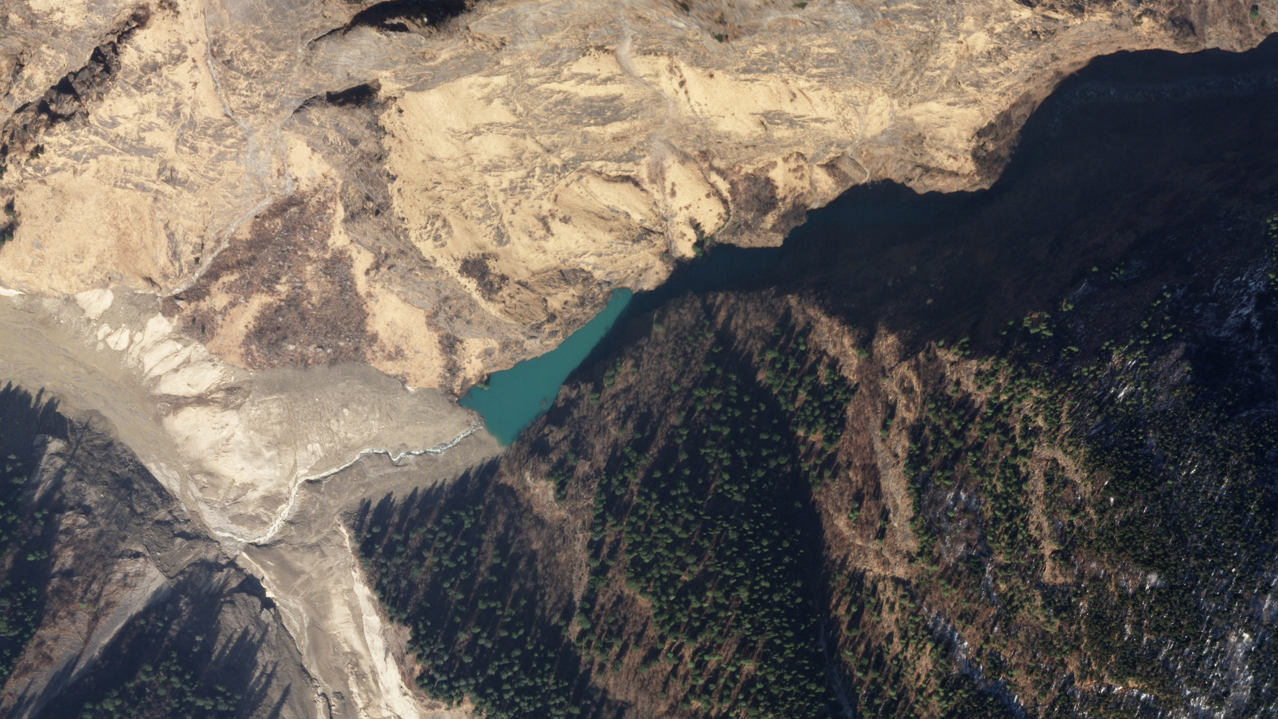
A perspective view of the landslide dam on the Rishi Ganga. Image copyright of Planet Labs, used with permission.
.
The good news is that there is a well-developed channel draining the lake, which has a modest volume. The risk downstream should not be ignored, but this does not pose the sort of threat that we saw at, for example, Attabad.
These images tell us something about the flow. I remain a little perplexed by the ongoing discussion about the source of the water in the flow, which seems to ignore the well-known observation that granular flows can occur with little or no water present. Large, dry granular flows give the appearance of having water present,even where they are dry, but they do generate considerable volumes of dust (as was the case here). Where they sweep down the valley, the front may become saturated as water is incorporated.
I am not arguing that the events on the Rishi Ganga were completely dry – they were not – but I do not think that we need to find a source for very large quantities of water. There was enough water present in the form of ice on the block that failed, and in the valley in the form of dead ice, snow and saturated sediments to explain the flow, in my view.
By the time the landslide reached the point shown above it was well-contained within the channel, as demonstrated by the intact trees on either side. There is some evidence of super-elevation on the outside of the bend. The landslide has dumped a large volume of sediment in this valley, which has been retained. The latter part of the flow appears to have eroded the toe.
I would be interested in the views of sedimentologists as to what the presence of this dam tells us about the characteristics of the flow. Comments?
.
Reference
Planet Team (2021). Planet Application Program Interface: In Space for Life on Earth. San Francisco, CA. https://www.planet.com/
 Dave Petley is the Vice-Chancellor of the University of Hull in the United Kingdom. His blog provides commentary and analysis of landslide events occurring worldwide, including the landslides themselves, latest research, and conferences and meetings.
The view of a humble engineer.
This explanation make good sense. The ” sturzstrom” could have been bone dry when it began and still have performed in a similar manner.
Since this is a side channel, possible slack water deposition as the main flow continued past?
Also of interest are the pair of well-developed high terraces on channel right immediately beyond the confluence. Possibly glacial moraine remnants? Unoccupied, though, which is odd in such a landscape where flat land to work is at a premium,
Interesting and helpful new images. With regard to the issue of water inclusion, I calculated that from the amount that could have been deposited long the valley floor downstream of the impact of the sturzstrom, based on 2017 images, the heat generated from the event could have been sufficient to melt up to around 1 million m³ or so of remnant ice. This figure can be revised once we have better access to good imagery of the valley floor from just before the event.
The NASA Earth Observatory website features the Chamoli Landslide for their 25 Feb 2021 Image of the day – https://earthobservatory.nasa.gov/images/147973/a-deadly-debris-flow-in-india – it has a really detailed view of the debris field.
The appearance of a lake behind a natural dam following the Rishi Ganga deluge of course is a safety concern but as pointed out rightly the self draining feature of the lake is encouraging. This is a matter of investigation as the sudden breach of the natural dam, however unlikely that may be, cannot be ruled out.
The sturzstrom concept as a mechanism for the Rishi Ganga flash floods, on the other hand, may provide a plausible explanation for generation of the flood water from an otherwise bone dry environment. According to the information from gauge and discharge site of the Central Water Commission (CWC) of India at Joshimath, some 10-15 km downstream of Tapovan – the site of the barrage for 520 MW Tapovan Vishnugad Hydropower Project of the National Thermal Power Corporation that got damaged during the flash floods, the peak flood discharge of about 1683 cumec dissipated in about two hours. Taking in to account the average river flow of about 15-20 cumec, the additional flood water is estimated at about 6 million m³, and, this had a source somewhere in the Rishi Ganga sub-basin. The explanation for the Rishi Ganga flash floods, therefore, hangs between a sturzstrom generating the estimated quantity of flood water in a short span of hours, if not in minutes, and the mechanism of a glacial lake with a frozen top getting breached by a land- or snow-slide. A full scientific investigation alone can answer this question.
It can be accepted that the comparatively dry granular flow could go up to the valley bottom at high speed but it is difficult to imagine that it could continue for long distances ie up to the confluence of the Alaknanda River. So it was definitely a saturated flow moving downstream along the valleys of Rishi Ganga and Dhauli Ganga. So it is required that source for large quantities of water be located and same could be a glacial lake. It is possible that same could have been obliterated due to impact of avalanche or landslide.
[But dry rock avalanches have exceptional runout, so I am not sure why this is not possible? There is no evidence of a glacial lake on the images taken the day before the landslide, and there is no evidence of the remains of a glacial lake in the post-event images either. I am struggling to understand why this glacial lake hypothesis remains in play when there is zero evidence to support it? D.]
Can dry rock avalanches have runout extending for tens of kilometers in narrow valleys where these should be halted by frictional forces offered by the tight and zig-zag nature of valleys. Possibly, thedry rock avalanche should not have reached Tapovan project with such an velocity.
Wow, this blog is a great resource—thanks for all the info!
It did look like a lot of water in the videos from Raini/Tapovan, to my untrained eye, but I didn’t know of any possible water source…so the comments on granular flow, and frictional melting were of great interest. But I did see a news story quoting a chap from the Uttarakhand Space Applications Centre that “it is not a new lake.” https://www.hindustantimes.com/cities/dehradun-news/no-new-lake-it-s-part-of-bigger-lake-that-caused-chamoli-disaster-experts-101613225293013.html
Not clear what time frame he is thinking of. But I wonder if there might have been multiple events over some period of time, and the lake has formed, drained, and reformed.
I hiked up the Rishi gorge in 1978, and there was no lake. I wasn’t aware enough to look for any signs of a previous or intermittent lake. There was snow avalanche debris across the river, but the flow continued underneath unimpeded.