
10 July 2016
Nagasaki, Uttarakhand and Pakistan: three new landslide videos
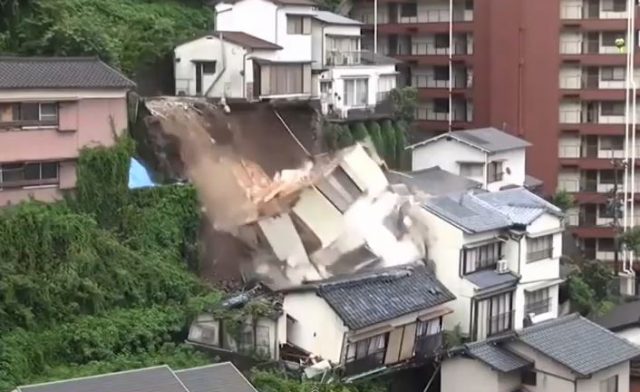
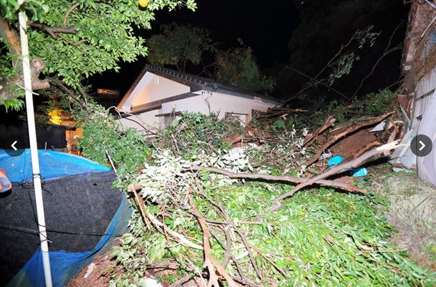
House collapse in Nagasaki, Japan via Youtube
A small number of new landslide videos have emerged on Youtube in the last few weeks:
A debris flow in Pakistan
This very cool debris flow video was published on 17th June. No details are provided:
.
A road slope failure in Uttarakhand, India
This collapse event apparently happened at Nainital in Uttarakhand in India. It was posted on 5th July 2016:
.
A house collapse as a result of undercutting in Nagasaki, Japan
This one happened in Japan earlier this month. It appears that a retaining wall below the building has failed, undermining the foundations:
3 July 2016
Lamplugh Glacier rock avalanche: A massive new landslide in Alaska on Tuesday
Lamplugh Glacier rock avalanche: A massive new rock landslide
The media in Alaska is reporting a find by a local pilot, Paul Swanstrom of Mountain Flying Service, of a huge new landslide, the Lamplugh Glacier rock avalanche, which occurred in Alaska on Tuesday. This is yet another enormous event in this area of North America – this is an image that he took of the landslide, which is posted on his company Facebook Page:
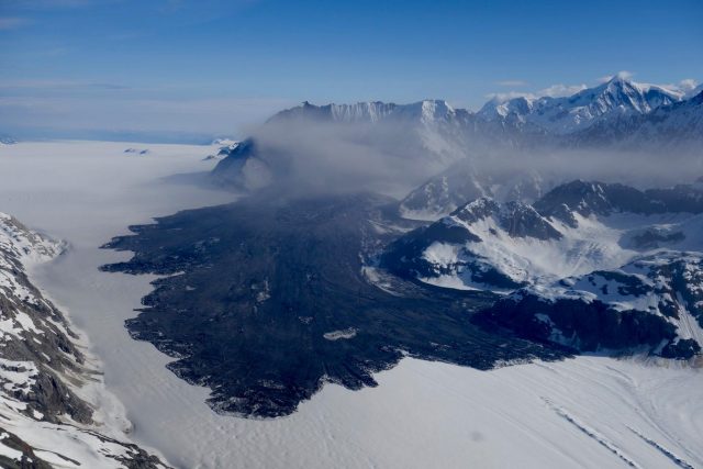
The Lamplugh Glacier rock avalanche via Paul Swanstrom
.
Paul estimates that the runout of the landslide is about 6 miles (i.e. about 10 km). In a KHNS Radio article about the landslide, Colin Stark of Colombia University estimates that the volume is about 150 million tonnes, presumably based upon an initial analysis of the seismic catalogue. The landslide appears to be recorded in the Alaska Earthquake Center catalogue as a M=2.9 event on 23rd June 2016 at 08:20 local time:
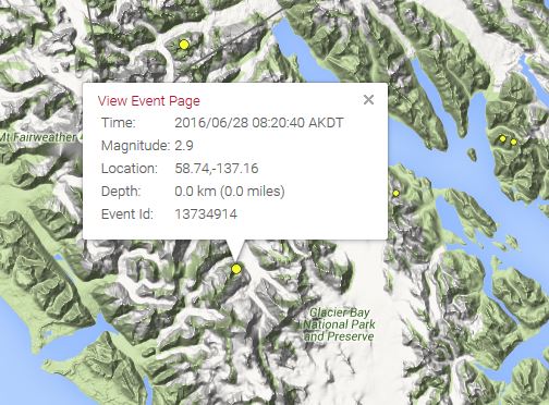
The Alaska Earthquake Center record of the possible seismic event generated by the Lamplugh Glacier rock avalanche
.
The landslide appears to be a very deep-seated, ridge crest to slope toe failure of unusually large proportions:
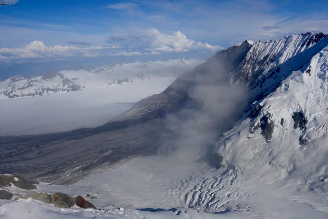
The source of the Lamplugh Glacier rock avalanche, via Paul Swanstrom
.
The landslide appears to have generated a highly mobile, broad and long landslide deposit on a comparatively low angled slope, probably consistent with flow of debris over an ice bed. The landslide has developed complex structures at the toe, probably associated with the final creeping stage of movement:
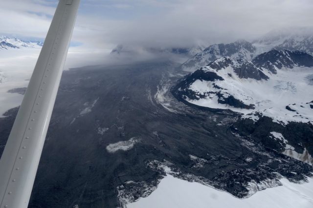
Flow structures in the Lamplugh Glacier rock avalanche deposit, via Paul Swanstrom
.
This is not an area with particularly good Google Earth imagery, but I think that this is the slope that failed:
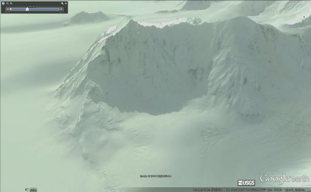
The probable site of the Lamplugh Glacier rock avalanche, via Google Earth
.
The crest of the slope appears to be at about 2030 metres elevation, and the break at the foot of the slope at about 875 m, giving a vertical extent of about 1155 metres. The toe of the deposit is at about 550 metres elevation, which means that the runout lost about 225 metres elevation over 10,000 metres, giving a travel angle of about 1.3 degrees. This is exceptionally low.
This part of Alaska is now firmly established as the global hotspot for rock avalanche activity. Recent events include the Tyndall Glacier Rock Avalanche, the Ferebee rock avalanche, the Mount La Perouse rock avalanche, the Mount Jarvis Rock avalanche and the Mount Lituya Rock Avalanche. A detailed study is urgently needed to understand why this area is so active at present.
29 June 2016
A massive secondary landslide in Devdoraki Gorge, Georgia
A massive secondary landslide in Devdoraki Gorge, Georgia
In 2014 I posted about a very large landslide that caused extensive damage in the Devdoraki Gorge (which is often described as the Dariali Gorge) in Georgia. That landslide left a very large volume of debris in the river bed. On 23rd June this debris mobilised into a new, secondary, landslide that caused extensive damage along the key highway that links with Georgia and Russia via the Kazbegi Customs checkpoint. Thanks to a warning system installed after the 2014 events, no-one was injured, but the damage appears to be significant. The road remains closed.
Agenda.ge has a couple of reports about the landslide and its impact. They have posted this image, taken by the Georgia Road Department, of the damage that this landslide has caused:
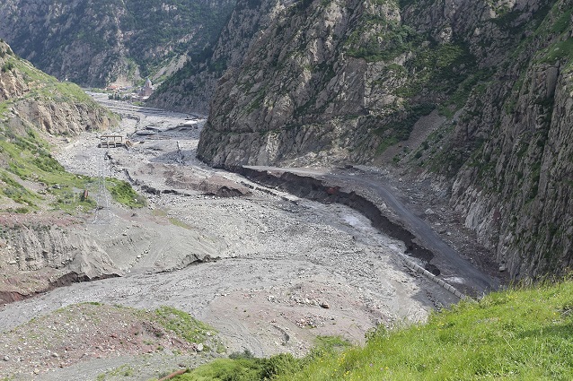
Landslide damage in Devdoraki Gorge, via the Georgia Roads Department and Agenda.ge
.
It is expected that clearing the blockage and repairing the road will take a fortnight. Exclusivenews.ge has an image that gives an impression of the magnitude of the task ahead:
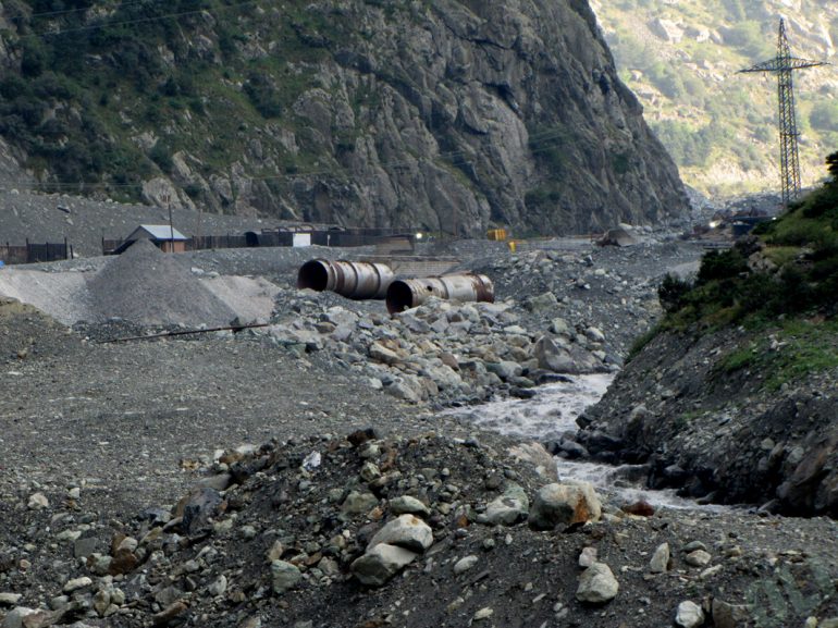
Landslide damage in Devdoraki Gorge, via Exclusivenews.ge
.
The origin of these landslides is the huge pile of sediment that has been left by the retreating Devdoraki glacier. Google Earth imagery, that predates the most recent landslides, shows the magnitude of the problem:
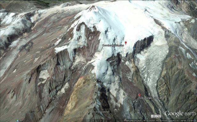
Google Earth imagery of the Devdoraki Glacier, showing the potential for significant landslides
.
It appears that further significant landslides are likely from this source, and thus that this river valley is likely to continue to be problematic. This valley is also the location if the Dariali Hydroelectric Power Plant (Dariali HPP) at an estimated cost of US$120 million. At the time that the Dariali HPP was being proposed there was considerable opposition on the basis of the potential for natural hazards, including sediment movement and mudflows. The impact of these multiple landslides on tghis scheme is not clear, but it appears from the top image that there is some HEP infrastructure in the river in the middle of the landslide deposit. A note (NB – this is a pdf) from an NGO, the Green Alternative, to the European Bank of Reconstruction and Development, highlights the problems:-
“There are at least three well known mudflow rivers Devdoraki, Khuro, Chkhere on the project site, that has been chosen in a way that the Dariali Hydro derivation channel portal is located exactly at the convergence of the Devdoraki and Tergi rivers and the Dariali dam, tank and headwork – just at the convergence of the Khuro and Chkhere rivers.”
The original landslide deposit is at the convergence of the Devdoraki and Tergi rivers.
The Dariali HPP is not the cause of these landslides, but is in close proximity. This most recent event is reported to have caused no damage however.
28 June 2016
New Zealand Society for Earthquake Engineering report on the Kumamoto Earthquake
New Zealand Society for Earthquake Engineering report on the Kumamoto Earthquake
The New Zealand Society for Earthquake Engineering has produced a report, available online, on the Kumamoto Earthquake. This is apt given that this area is once again suffering very heavy rainfall today – this is the Japan Meteorological Agency landslide hazard map as I write:
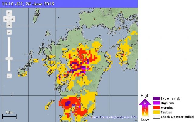
Japan Meteorological Agency landslide hazard map for the Kumamoto Earthquake area for the afternoon of 28th June 2016
.
Fortunately, so far at least, rainfall totals have not approached those of earlier in the month.
The New Zealand Society for Earthquake Engineering report provides some real insight into the landslides triggered by the Kumamoto Earthquake. It notes that of the 49 deaths in the earthquake, 10 were caused by landslides, of which five occurred at a site at Aso Ohashi Village shown below. This is the source area of the earthslide / flow:-
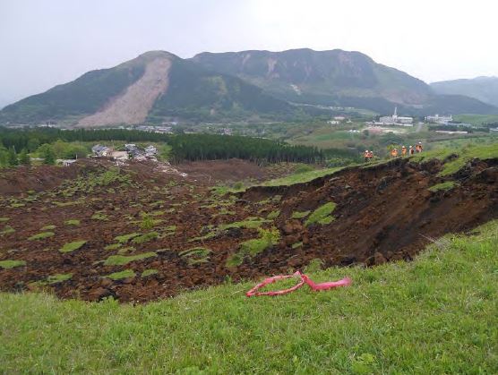
The source area of the Aso Ohashi earthslide / flow via the New Zealand Society for Earthquake Engineering report
.
Whilst this the zone of maximum damage at the toe:-
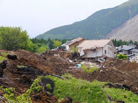
The damage zone for the earthslide / flow at Aso Ohashi Village, via the New Zealand Society for Earthquake Engineering report
.
Of course the best reported landslide in the Kumamoto Earthquake was the large debris avalanche at Aso Bridge. The report also provides a nice image of this landslide:-
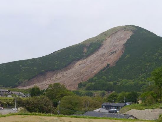
The large debris avalanche at Aso Bridge via the New Zealand Society for Earthquake Engineering report
.
The report notes that this landslide is 950 m long by 200 m wide, and that it caused at least one fatality. What is not often reported in the aftermath of earthquakes is the large numbers of small landslides that have caused local damage. The loss in each event can be comparatively small, but their cumulative impact can be large. This is an example of two small landslides, one of which has caused the failure of a bridge abutment and the other (circled in red) of a cantilevered section of road:
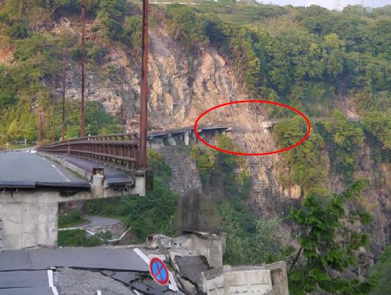
Two small but damaging landslides from the Kumamoto Earthquake, via the New Zealand Society for Earthquake Engineering report
.
There are lots of other reports on the Kumamoto Earthquake on the EERI website. There are some amazing resources there.
26 June 2016
Landslides in Art Part 26: Robyn Collier
Landslides in Art: Robyn Collier
This, the 26th edition of Landslides in Art, features a painting by the Australian artist Robyn Collier. Robyn’s bio on her excellent webpage describes her as follows:
Robyn is well-known as a prominent Australian wilderness landscape and seascape painter of contemporary realism who started painting in the early 70’s – when traditional art was really taking off and Sydney Galleries were frequent and successful. Most of what she has learned has been learned from the observation of nature and constant hard work – being a self realised artist. Having spent many years painting en plein-air she then graduated to studio work and subjects requiring more time and reference while still retaining the Alla-Prima technique. (Direct painting, wet-in-wet).
Robyn has bush walked extensively over her 40 year career as a visual artist and still walks several times a week. Her real love is traveling to remote areas – wilderness subjects and areas of difficult access being her special niche.
The piece of work I am featuring here is called “The Landslide“, described by Robyn as follows:
A landscape I was very happy with – painted after a long, but beautiful walk to the Ruined Castle.
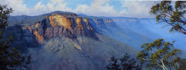
The Landslide by Robyn Collier
.
The Ruined Castle is in the Blue Mountains National Park in New South Wales, western Australia. This image appears to show the same site:
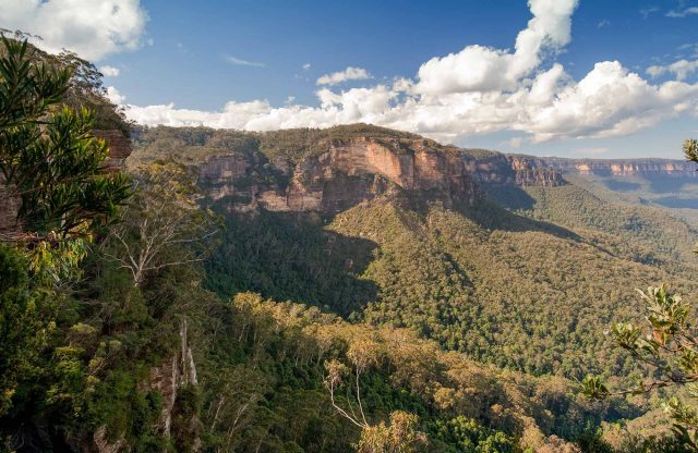
Landslides in Art – Robyn Collier. Image from NSW Parks and Wildlife Service
.
The painting beautifully captures both the majesty of the site and the dynamic nature of the landslide itself. The slide is a large rockfall that is reasonably fresh (but it is very hard to date in an environment with very slow process rates), with an enormous forested rockfall deposit at the toe (which must have formed over many events).
The location of The Landslide
I think this is the site on Google Earth (but unfortunately the vertical imagery creates many distortions). The site is at (-33.732, 150.295):
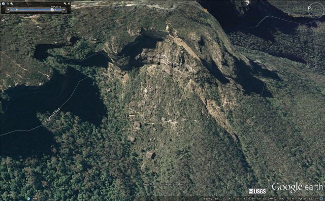
The site of The Landslide by Robyn Collier, via Google Earth
.
Unfortunately this truly beautiful painting of a landslide has been sold. I envy the owner.
25 June 2016
A peat bog landslide in Galway, Ireland
Galway peat bog landslide
Various news agencies in Ireland are reporting a peat bog landslide at Clifden in Galway on Thursday night. Reports suggest that 4000 tonnes of material have shifted, blocking the N59 Connemara to Galway city road. Reports suggest that the slope was still moving on Friday.
Peat bog landslides are quite unusual (not least because peat bogs are quite rare), and behave in a manner that is also a little different. This is because the main mass of the landslide is saturated organic material that has a low density. This makes them unusually mobile once they are disturbed. I blogged about a set of peat bog landslides in Ireland back in 2009.
The best view of this peat bog landslide comes from a Youtube video of drone footage:
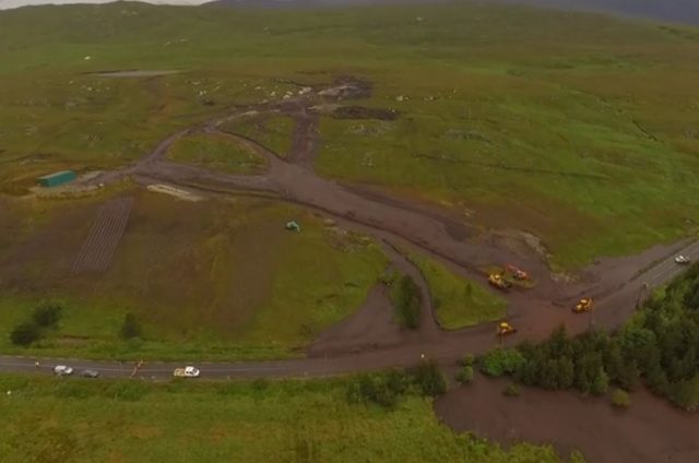
The Galway peat bog landslide via Youtube
.
Notice the very disturbed area at the crown of the landslide, which is typical of a peat bog landslide. The mobility of the slide is clear as the mass has moved on an unusually low angled slope.
This is the full video of the landslide:
.
Details about the Galway peat bog landslide
The location of the landslide appears to be at 54.4778, -9.8981 (54.4778 N, 9.8981 W). There is good imagery of the site on Google Earth, taken in 2011:
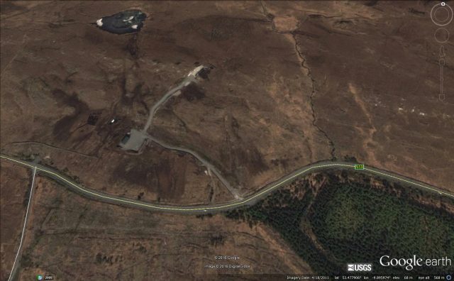
Google Earth imagery of the Galway peat bog landslide, taken in 2011
.
Peat bog landslides are usually associated with heavy rain, as appears to be the case here. Sometimes disturbance of the slope by human activities also plays a key role, but there is nothing to indicate that was the case here. Of course peat bogs take hundreds of years to form, so these events have a long legacy. As peat is also an important store of carbon, it should be actively preserved where possible. Sadly, the rapidly increasing rainfall intensities that are being seen in many places as a result of climate change means that these sorts of events are likely to become more common.
22 June 2016
Pingle County: quarry collapse kills seven in Guangxi Zhuang, China
Pingle County quarry collapse
Xinhua reported on Monday that a quarry collapse had trapped seven people in Pingle county, Guangxi Zhuang Autonomous Region in China. They provided little detail other than to say that rescue operations were ongoing. However, CCTV has now posted a very high quality video of the site, and of the rescue operations, on Youtube:
.
Based on the images this looks to be a classic rockslope failure caused by undercutting during the quarrying. This is a still from the video:
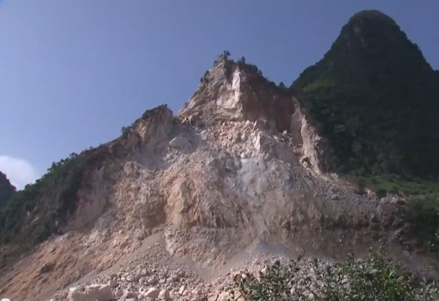
Pingle County rockslope collapse, via Youtube
.
I think that on the upper part of the scar the detachment may well be controlled by two large joints. This would explain the very hefty boulders in the rockfall deposit. Note also the very clear horizontal discontinuity running across the lower slope. The rockslope collapse has generated a deposit that is exceptionally coarse-grained:
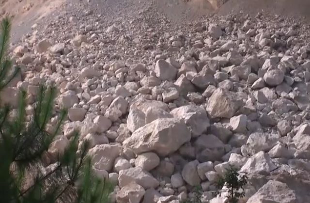
Pingle County rockfall deposit via Youtube
.
The ongoing rockfall activity, and the potentially unstable nature of the remaining rock mass, means that the rescue operations are extremely hazardous. Sadly I can think of no examples in which people have been successfully rescued from beneath a deposit of this type. I suspect there may be cases, but they are rare, and they will always require that the survivor was sheltered in some sort of structure.
Once again the desperate need for improved quarry and mining safety in China has been highlighted. The toll from quarry landslides there remains fearsome.
Heavy rains across southern China
Meanwhile, Xinhua is also reporting the terrible toll from the heavy rains that are currently affecting the southern part of China. Floods and landslides are reported to have killed 22 people to date, with another 20 missing. This includes a substantial landslide in a railway construction site in Sichuan Province:
In Xingwen County, southwest China’s Sichuan province, five more bodies were found at a railway construction site, bringing the death toll from landslides in the county to seven. Following heavy rain, a landslide occurred around 3 a.m. Sunday that destroyed workers’ dormitories. Three people were hospitalized, they remain under observation but are in a stable condition.
21 June 2016
Kumamoto earthquake: post-seismic landslides kill at least three, two missing
Kumamoto earthquake: post-seismic landslides
One of the most serious concerns about the Kumamoto earthquake in Japan was that the timing, shortly before the rainy season, meant that there was high potential for post-seismic landslides. These have frequently proven to be problematic – in essence the first exceptional rainfall after the earthquake tends to drive a spike in landslide activity, with potentially disastrous effects. In the Kumamoto earthquake large numbers of slopes were left in a fragile state. Yesterday, heavy rainfall across the prefecture triggered extensive landslides and flooding. The Asahi Shimbun has a summary of known losses so far:
- In Kamiamakusa a 92-year-old man was killed in his house by a landslide.
- In Uto two houses were buried, leaving one man dead and a woman missing.
- In Kumamoto city two people were trapped by a landslide in their home. One has been confirmed dead, the other is missing
There was also a flood-related death – a 79-year-old man who fell into a drainage ditch and drowned in Kosa.
The Japan Meteorological Agency provides a real time landslide risk map. This is how it looked yesterday (via Robert Speta and Twitter):-
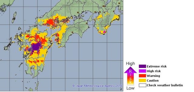
Kumamoto earthquake – landslide risk map for 20th June from the Japan Meteorological Agency
.
And again this morning (direct from the Japan Meteorological Agency website):-
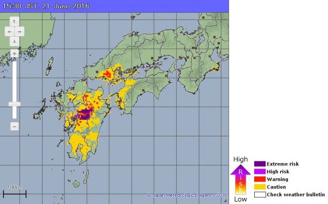
Landslide risk map for the Kumamoto Earthquake zone on 21st June via the Japan Meteorological Agency
.
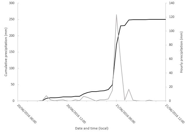
The agency also provide precipitation data online, which makes sobering reading. This is the record for the Kumamoto weather station, based on hourly records:
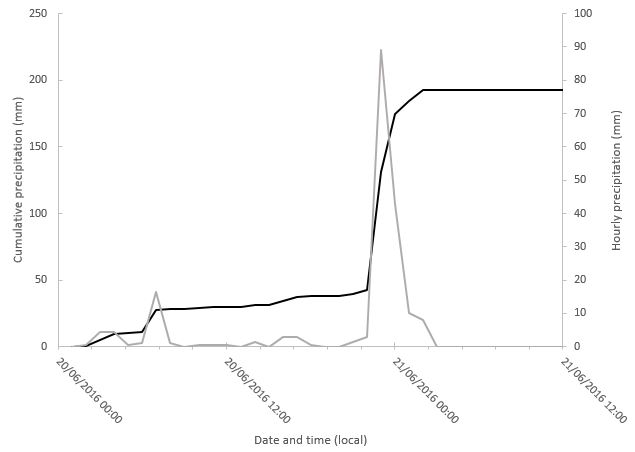
Precipitation data for the Kumamoto weather station, data via the Japan Meteorological Agency. The grey line is hourly precipitation (right hand axis), the solid line the cumulative rainfall since 00:00 on 20th June 2016 (left hand axis)
.
Rainfall will have been very variable across the region, but in Kumamoto itself the impact seems to have been a short burst of extremely intense rainfall – 89 mm fell in a single hour. Sadly this occurred late in the evening, when people are least likely to be able to see or even hear a landslide coming. Kosa, mentioned above, is even worse:-
Precipitation data for the Kosa weather station, data via the Japan Meteorological Agency. The grey line is hourly precipitation (right hand axis), the solid line the cumulative rainfall since 00:00 on 20th June 2016 (left hand axis)
.
In this case the maximum hourly precipitation was a staggering 123.5 mm. Again the most intense rainfall arrived in a short duration, very high intensity burst with devastating consequences. This is one of the landslides in Uto:
A landslide in Uto, in the Kumaoto Earthquake area, via Jun Kaneko and The Asahi Shimbun
20 June 2016
Central Java: disastrous landslides in Indonesia over the weekend
Central Java: disastrous landslides in Indonesia over the weekend
Heavy rainfall in Central Java, Indonesia triggered landslides and floods over the weekend, with disastrous consequences. The headline seems to be 46 confirmed fatalities with a further 27 people reported to be missing, although this is not entirely clear at the moment. I have been trying to glean information from various news reports:
- The Jakarta Globe reports 29 people were killed in Purworejo, all by landslides, with a further 11 still missing.
- The Jakarta Globe also reports 17 people killed in Banjarnegar, with a further 6 missing.
In terms of specific landslide incidents:
- On Saturday a landslide at Sampang Village (also reported as Dukuh Pohkumban) in Sempor district, Kebumen reportedly buried three houses, killing six people
- In Karangrejo, Caok nine people were killed according to Anshora
- Also on Saturday nine people were killed at Gumelem by a landslide on a road. Reports suggest that the victims were clearing the debris from one landslide when they were struck by another.
- A landslide reported as occurring at Donorati reportedly killed 11 people.
- A landslide at Sidomulyo Village in Purworejo reportedly killed five people
- In Mranti two people were reportedly killed
- In Jelok village in Kaligesing a landslide killed three people
- And in a landslide in Bagelan (also reported as Parry, Berjan) one person reportedly died.
The total from the above is 46 people, which tallies with the headline above, although I suspect that this might be more luck than judgement. If anyone can provide better information then I would appreciate it.
There are a few images of the landslides on the internet. This one, from Purworejo, suggests that some of the landslides have been quite large:
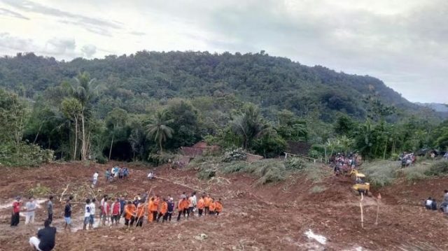
One of the landslides at Purworejo, via Tribun Jateng
.
Whilst this one was posted on Twitter:
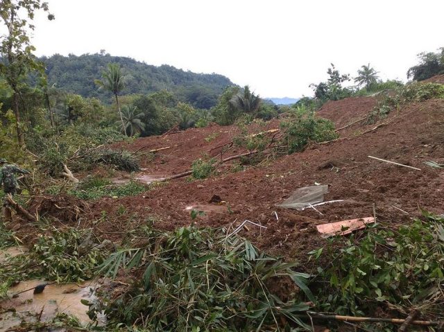
A landslide in Central Java, via Twitter
.
Hopefully more information will appear over the next few days.
18 June 2016
Using climbing guides to examine changes in rockfall activity in the European Alps
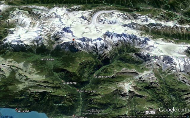
Google Earth image of part of the Bernese Alps, the subject of the study on the use of climbing guides to look at changes in rockfall activity
Using climbing guides to examine changes in rockfall activity in the European Alps
One of the anticipated, and increasingly observed, effects of anthropogenic climate change is the degradation of permafrost in high mountain areas. A key role of permafrost is in holding fractured rock masses together. As the ice melts, the strength of the rock mass rapidly declines, and rockfalls result. Given that some mountain areas, such as the European Alps, have already shown 2 degrees Centigrade of warming, these effects are already with us, and are getting worse. But of course it can be hard to assess the level of rockfall activity prior to the modern instrumental age. As this was not a parameter that was being monitored until recently, understanding of this problem in a historical context is hard.
In a recent paper in the journal Geografiska Annaler, the climber and geomorphologist Arnaud Temme has examined warnings of rockfall activity in Alpine climbing guides over a 146 year period in the Bernese Alps of Switzerland. This is an area that has been extensively climbed for well over a century, with a regular flow of climbing guides through this period. Some of these guides are one-off descriptions by the authors, whilst in others the same author has provided repeated updates. Temme (2015) describes this as an early form of crowd-sourcing of rockfall activity. Of course a substantial advantage here is that climbers have to be very aware of rockfall danger, and the authors are often acute observers of the behaviour of the rock mass. Whilst this is not a real substitute for quantitative data, it does provide very interesting insight into the effects of climate change in high mountains.
The study focuses on 17 Swiss Alpine Club guidebooks dating from 1864. The first four were written by the same English author (Bell), whilst later versions had more local authors. The analysis in the paper is sophisticated because of the need to take into consideration changes in the number of routes described and changes in societal views of risk, as well as changes in authorship. But, allowing for these factors, the results are clear. There has been a strong increase in the reported occurrence of rockfall danger. Temme (2015) presents this graphically:
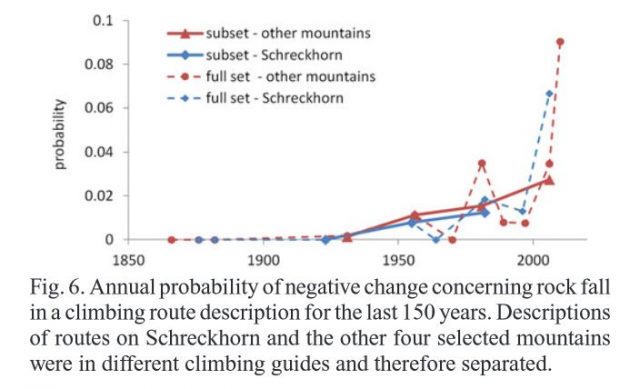
Changes in the perceived danger of rockfalls in the Bernese Alps in climbing guides, from Temme (2015)
.
It is clear that there has been a remarkable increase in the description of rockfall danger over the period, and that most of this has occurred in the last three decades. Whilst an aspect of this could be a increased sensitivity to risk. Temme (2015) is clear that the major factor is increased rockfall activity. In the analysis he also looked at the correlation of this increased rockfall risk with various physical factors, and found that there was a strong relationship with slope aspect. This is consistent with increased rockfall activity occurring on slopes with an eastern or western aspect, where the freeze-thaw effect is known to be strongest.
This is another study that shows elegantly that anthropogenic climate change is having a strong effect on landslide activity. Of course there is an opportunity to continue this study in other intensively-climbed areas of the European Alps, and to use climbers as a crowd-sourced provider of rockfall data.
Reference
Temme, A.J.A.M., 2015. Using climber’s guidebooks to assess rock fall patterns over large spatial and decadal temporal scales: an example from the Swiss Alps. Geografiska Annaler: Series A, Physical Geography. 97, 793–807. doi:10.1111/geoa.12116
 Dave Petley is the Vice-Chancellor of the University of Hull in the United Kingdom. His blog provides commentary and analysis of landslide events occurring worldwide, including the landslides themselves, latest research, and conferences and meetings.
Recent Comments