
17 June 2016
Review of a paper: fatal landslides in Europe
Review of a paper: fatal landslides in Europe
In a paper just published in the journal Landslides, Haque et al (2016) present an analysis of fatal landslides in Europe between 1995 and 2014. This is an interesting piece of work that sits nicely alongside the work that I have published on worldwide landslide losses Petley (2012) and in Latin America (Sepulveda and Petley 2015). In this period the authors have recorded a total of 476 landslides causing losses of 1370 people, with a further 784 injuries. The paper deserves careful reading as it contians a great deal of information, of which I will pick out just two elements.
First, the paper includes a map of landslide losses over this period, organised by 5 year blocks:
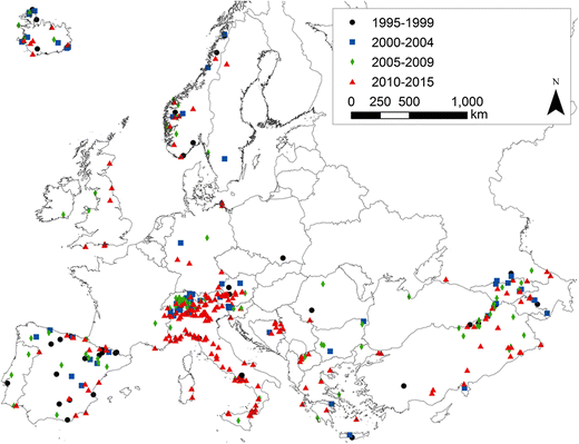
The spatial distribution of fatal landslides in Europe, from Haque et al. (2016)
.
As expected, the spatial distribution of fatal landslides is very heterogeneous, with a higher concentration in Iceland, the Alps, the Apennines of Italy and in Turkey. France has surprisingly few, Spain a fairly even scattering. Much of the rest of the Europe has a small number. The location of the landslides of course reflects the distribution of mountain areas, and in particular those with seismicity. This is consistent with my earlier studies.
Second, perhaps the most surprising element of this study though is the data on the trend in landslide occurrence with time. This is the graph presented in the paper:-
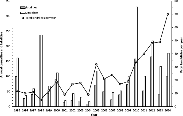
The annual number of landslides, and landslide losses, for fatal landslides in Europe, from Haque et al. (2014)
.
The trend is clearly upwards over time, sharply so in terms of the number of landslides from about 2009 onwards, with a significant increase in losses as well. This was not clear in my global data, and we did not see this trend in Latin America either, so this is a very interesting result. Haque et al. (2016) suggest that the increase is primarily the result of large numbers of fatal landslides in Italy and Turkey (see the red triangles on the map above) and in the Balkan countries. The cause of this change is not clear, but the authors note that most of these landslides occurred in mountain regions with a humid temperate climate. This hints at a possible role of climate change.
Overall this is a very valuable study that is extremely welcome. It would be good to see a similar study for East Asia and for South Asia now as well. I hope that this database will be maintained.
References
Haque, U. et al. 2016. Fatal landslides in Europe. Landslide. Doi: 10.1007/s10346-016-0689-3
Sepúlveda, S.A. and Petley, D.N. 2015. Regional trends and controlling factors of fatal landslides in Latin America and the Caribbean. Natural Hazards and Earth System Sciences, 15, 1821-1833, doi: 10.5194/nhess-15-1821-2015.
Petley, D.N. 2012. Global patterns of loss of life from landslides. Geology 40 (10), 927-930.
16 June 2016
Landslide video: a massive landslide takes out a truck in Peru
Landslide video: a massive landslide takes out a truck in Peru
I know nothing about the circumstances of this video, which was reportedly shot on a mountain road in Peru, or how it worked out for the driver of the truck. Sadly, I suspect not well:-
.
This is a truly massive landslide, but the initial impact on the vehicle was to push it forward rather than burying it:
A truck being struck by a landslide in Peru via Youtube
.
The video was posted on 11th June, but I have seen no reports about this event. Can anyone provide any more information?
15 June 2016
The boulder that came to tea
The boulder that came to tea
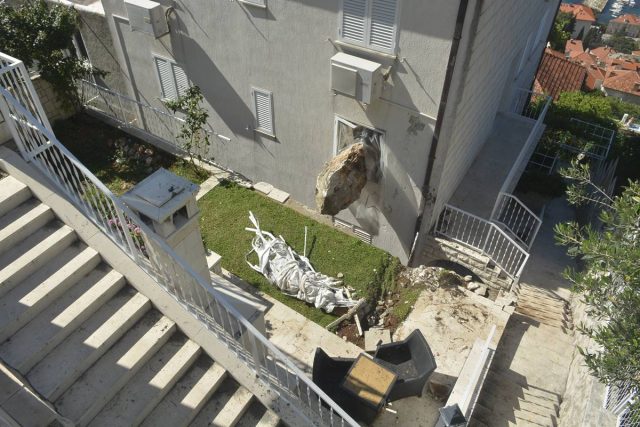
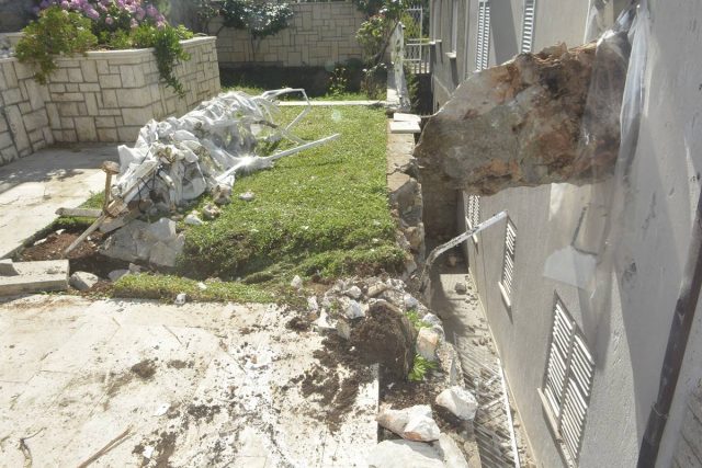
The Croatian news website Dulist has a story this week about a boulder that came to tea in a house in Dubrovnik. The pictures are quite startling:-
The boulder that came to tea – via Dulist
.
According to a translation of the article, this landslide happened during heavy rainfall on Monday night. This block was part of a larger landslide on State Road D-8. The images suggest that this boulder bounced on the road before smashing through the broadside barrier:
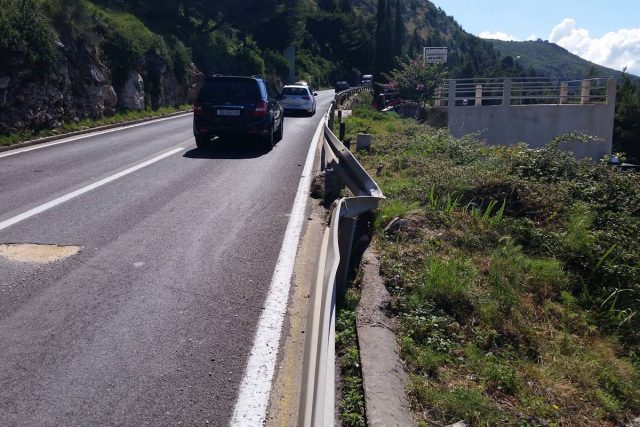
The boulder that came to tea – the roadside impact, via Dulist
.
And then bounced again in the garden of the house (note the huge divot in the grass), before trying to gain entry via the a bedroom window:-
The boulder that came to tea, via Dulist
.
This looks to be a classic case of a boulder that is rotating around its shortest axis, and so has gained a stable geometry as it travels down the hill. This situation creates the possibility of high velocities, large bounces and long travel distances.
I’d imagine that removing the boulder from the window is not going to be a trivial task
According to the Dulist article, the same house was struck by a boulder in 2012. The Google Translation of the article, which I have tidied up, says:
The Křečková house has already been hit by a big boulder, almost exactly four years ago, namely on 16 June 2012, when the rocks in the fall broke several trees, skipped the road, bounced off the railing of the road, glanced off the fence sound the driveway parking and travelled like a projectile through the roof of the house. Fortunately the roof structure was able to stop the rock.
All of this suggests that some work is needed quite urgently to assess the stability of the slope above the road. The article appears to suggest that there may be more unstable blocks.
13 June 2016
Three forthcoming landslide meetings of interest
Forthcoming landslide meetings
Three forthcoming landslide meetings of interest
I thought I would highlight three forthcoming landslide meetings:
1. GSA 2016 in Denver, Colorado
The 2016 GSA meeting will be held in Denver from 25th to 28th September 2016. There are three landslide sessions:
T21. Bridging the Gaps on Subaerial, Lacustrine, and Submarine Landslide Research
Lesli Wood, Lorena Moscardelli
Submarine landslides are never witnessed, but the aftermath is clear: destruction of seafloor infrastructure, disruption of biota, and tsunamigenic coastal threats. This session looks at researchers attempting to bridge between subaerial and submarine landslide processes.
T24. Landslide Hazards: Inventories, Hazard Maps, Risk Analysis, and Warning Systems (Posters)
William J. Burns, Stephen L. Slaughter, Matthew M. Crawford
This session is designed to highlight landslide hazards information especially as related to landslide inventories, hazard maps, risk analysis, and warning systems.
T25. Landslides, Debris Flow, and Rock Fall: Processes and Hazards
Rex L. Baum, Benjamin B. Mirus
This session will explore new insights about landslide processes and hazards. Contributions that address novel field and instrumental observations, analysis, and hazard assessments or that introduce tools and techniques applicable to any of these are especially welcome.
The abstract deadline is on 12th July. Details here.
.
2. Waiting for the End of the World: The Archaeology of Risk and its Perception in the Middle Ages
This meeting will be held in Oxford from 2nd to 4th December 2016. Details are as follows:
3. 2017 North American Symposium on Landslides
A reminder that this meeting will be held from 4th to 8th June 2017 in Roanoke, Virginia. The abstract deadline is 30th June 2016. Details here
9 June 2016
The response of Californian earthflows to drought
The response of Californian earthflows to drought
A really interesting paper has just been published in Geophysical Research Letters examining the response of Californian earthflows to the ongoing, epic drought. This paper was led by Georgie Bennett, currently at the US Forest Service and Colorado State University, but who will be joining us here at the University of East Anglia in January 2017 as a full faculty member. California has been suffering a serious drought for many years now. In the paper, Bennett et al (2016) mapped 98 active earthflows in a 140 square kilometre area of the Eel River catchment in California. This is an area with multiple large, often deep earthflows that are an important part of the geomorphic system. I have taken one of the larger earthflows from Google Earth below:
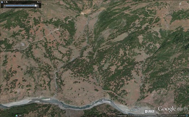
One of the Californian earthflows mapped by Bennett et al. (2016), via Google Earth
The mapping was very detailed, undertaken using aerial photographs. The mapping focused not just on the boundaries of the landslides, but also on the displacement of trees located on the landslides, which allowed a calculation of the velocity of the landslides with time. This data was then compared with an index of drought, the commonly-used and widely accepted Palmer Drought Severity Index (PDSI), which has been used previously to show that the 2012-2015 drought in California is unprecedented.
The results are fascinating – I highlight here two key aspects. First, over the last 70 years or so the velocity of the earthflows has markedly decreased. This image shows the mean velocity, with error bars and the PDSI. It is notable that in recent years the PDSI has become exceptionally low, and the earthflows have responded by slowing down:
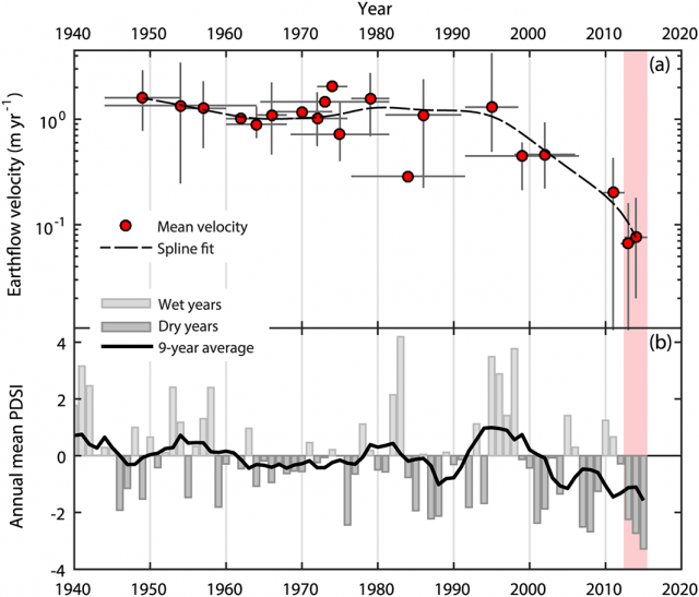
The response of Californian earthflows to drought, from Bennett et al (2016)
.
Bennett et al. (2016) also looked at the differential response of the Californian earthflows of different depths to the drought conditions. They found that the shallower (typically 5 – 15 m thick) landslides showed quite variable response to the drought conditions, with the majority slowing down but a few actually accelerating. However, all of those deeper than 15 metres decelerated. In some ways I find this a quite surprising result – I would have expected that the deep landslides would have been less susceptible to the climate than the shallow ones. The result is robust, but the cause is not clear and is intriguing. Bennett et al (2016) suggest that it could be that the shallow landslides respond to short term and local effects (vegetation change, a large storm) that might occur within a drought, whilst the deeper Californian earthflows are just responding to the climate forcing.
This is a really interesting study, showing very elegantly the ways in which the landslide system is responding to climate change. With greater changes to come in the years ahead as the global climate warms further, we will see many more responses of this type.
Reference
Bennett, G. L., Roering, J. J., Mackey, B. H., Handwerger, A. L., Schmidt, D. A. and Guillod, B. P. 2016. Historic drought puts the brakes on earthflows in Northern California. Geophysical Research Letters. Doi: http://dx.doi.org/10.1002/2016GL068378
8 June 2016
Copiah County: a fatal landslide accident in a gravel quarry
Copiah County: a fatal landslide accident in a gravel quarry
In Copiah County in Mississippi a landslide on Friday engulfed two quarry workers and an excavator. The landslide occurred at the Harmony Mine and Mill in Crystal Springs at about 1 pm. Efforts have been ongoing since to recover their bodies, but this is proving to be an extremely challenging operation. As of nightfall last night this had not been accomplished. MS News has a timeline of the events to date – on Sunday efforts were made to recover the excavator using a 230 ton crane, but without success.
WJTV12 has a report about the accident and the recovery works. This image appears to show the landslide mass and the buried excavator, of which just a small part is visible:
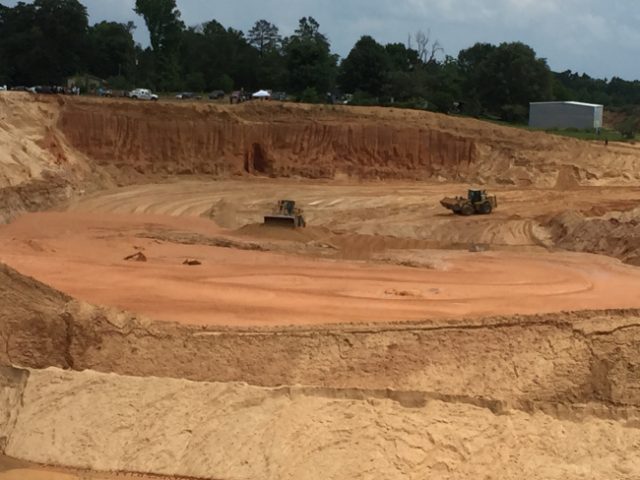
The site of the Copiah County landslide in Mississippi via WJTV12
.
Based on this image the landslide appears to have been highly fluid – note the lack of surface morphology, suggesting that the landslide as flowed. This is likely to make the recovery operations very difficult as the deposit is probably very weak. Unfortunately there are likely to be be high suction forces, which makes extracting the machine without excavating around it very difficult.
The landslide occurred during very heavy rainfall. Clearly there will need to be some work to try to investigate and understand what happened to generate a landslide like this.
7 June 2016
Review of a paper: dam break risk for the Attabad landslide
Dam break risk for the Attabad landslide
In a paper just published in the journal Landslides, Chen et al. (2016) have analysed the stability of the Attabad landslide dam in northern Pakistan, and the potential impacts of such an event on downstream infrastructure. This is a very important study, given that the landslide continues to impound a vast quantity of water in a well-populated valley.
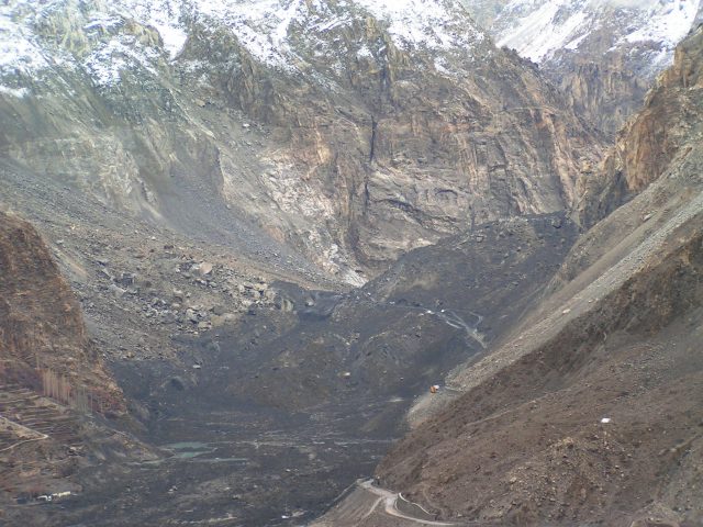
The Attabad landslide dam prior to the 2010 overtopping event
.
The paper contains some important and interesting background information, not least a graph of the water depth against time. This appears to be a similar dataset to the one that I was updating on a daily basis on the dedicated blog that I ran at the time, but the record is longer. It is not clear where the data has come from as I was not aware that there was monitoring by any other parties at the time. It’s good to see a full dataset. More importantly, the team have analysed the likelihood of a full dam break event using an empirical relationship derived from previous studies based on the so-called Dimensionless Blockage Index (DBI). Chen et al. (2016) conclude that:
The statistical analysis of the 84 natural landslide dams indicated that a dam is stable when DBI <2.75, quasi-stable when 2.75 < DBI < 3.08, and unstable when DBI >3.08…The DBI of the Attabad landslide dam is 4.62–4.85, which is greater than 3.08 and indicates that the dam is unstable and that there is a risk of a breach in the Attabad landslide dam.
However, the authors do not believe that a breach event would lead to release of all of the impounded water (this is probably correct in my view). This is fortunate as the authors have analysed the likely magnitude of a break flood at the site of the Attabad landslide dam itself. Such a full breach event would generate a calculated peak discharge of 175,145 cumecs (cubic metres per second), whilst a 50% breach would generate 44,904 cumecs. The flood would dissipate downstream, but a 50% breach is calculated to generate a peak flow of almost 16,000 cumecs at Gilgit Bridge, 100 km downstream.
Thus, the authors recommend that there is a continued need for risk management at the Attabad site. They conclude that:
In addition to continued monitoring of the upstream water inlet, lake water levels, and seepage and piping downstream of the dam, hazard zones and safe zones should be delineated in accordance with the results of the risk assessment of the Attabad landslide dam. Sanctuary sites, escape routes, and early warning signals should be pre-selected and pre-planned, and necessary material stockpiles should be prepared. A plan for construction during high-risk periods should be considered, and contingency plans for secondary disasters from the landslide lake should be distributed. The risks of disasters and potential losses should be reduced to the greatest extent possible.
I can only agree. The risks at the Attabad landslide dam site are far from negligible.
Reference
Chen, X., Cui, P., You, Y., Cheng, Z., Khan, A., Ye, C. and Zhang, S. 2016. Dam-break risk analysis of the Attabad landslide dam in Pakistan and emergency countermeasures. Landslides. Doi: 10.1007/s10346-016-0721-7
6 June 2016
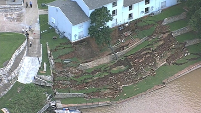
Granbury, Texas: a lakeside landslide that threatens an apartment block
Granbury, Texas
Over the weekend an interesting, but to those involved distressing, landslide developed at the town on Granbury in Texas, threatening a four-storey apartment block. NBCDFW have a couple of decent images, including this one, of the landslide:
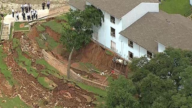
The landslide at Granbury, Texas via NBCDFW
.
This image, showing most of the failed slope, is from Fox 4 News:
Granbury, Texas landslide via Fox 4 News
.
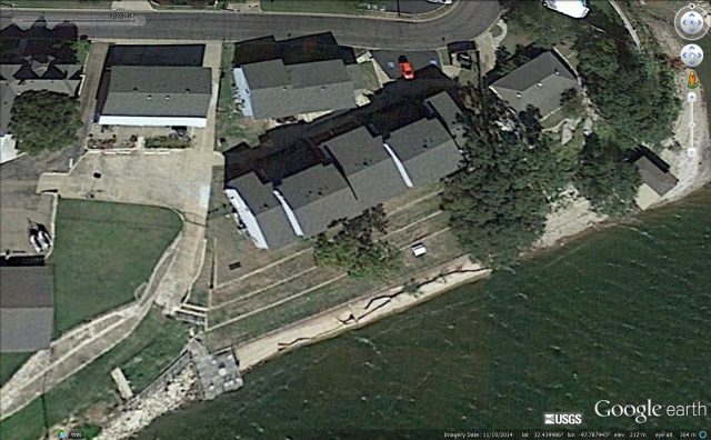
It is hard from the image to know what has happened at this site. It is clear that the retaining wall at the toe of the slope has buckled and displaced outwards. Did the slope fail, displacing the wall, or did the wall fail, triggering collapse of the slope? Or some combination of the two? There may be a hint in the Google Earth imagery, which seems to show something a little odd. This is the site, taken in late 2014:
Google Earth imagery of the site of the landslide at Granbury, Texas, taken in 2014
.
In this image the lake / river level is much lower than it is at present. There appears to be some sort of structure below the wall – is this a toe weight, or some sort of erosion protection? The image seems to show that this body has large black structures. An initial interpretation might be that these are cracks and fissures, but I am unsure. If so they are very large (and similar structures are seen elsewhere on the riverfront too). I have no idea what these represent – an artifact on the image? Or signs that the toe of the slope was damaged? Sometimes landslides like this occur when the toe of the slope is damaged, unloading the foot of the landslide, decreasing stability. Then, as pore pressures rise during heavy rainfall, the slope fails from the toe upwards. But it is very hard to tell based only on these images, and no form conclusions can be drawn in this case.
I am sure that this will be investigated properly, so it’ll be interesting to see what emerges. In the meantime, the news items report that the insurance company has declined to cover the costs of the damage, which could be as much as $1 million. The owners of the property have set up a GoFundMe page. As of this morning this had raised $5 of the £2 million target.
5 June 2016
Three interesting new landslide videos – Colombia, Hechi in China and Anatolia in Turkey
Colombia landslide video
During my work and travel-induced blog hiatus over the last fortnight, three new landslide videos have appeared on Youtube, from Hechi in China, Anatolia in Turkey and Colombia. None of the three provide much information. The first is apparently from Colombia, showing the collapse of a reinforced slope adjacent to a tunnel portal. The latter is destroyed in the landslide:-
.
I know no more about this landslide, but would observe that the reinforcement of the slope looks to be completely inadequate for the magnitude of the excavation. The failure seems to start directly above the tunnel portal, and then to propagate along the slope:-
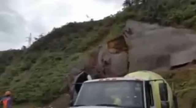
Colombia landslide on tunnel portal, via Youtube
.
A classic earth flow in Hechi, China
The second is a beautiful earth flow landslide on a road in Hechi, located in Guangxi Zhuang Autonomous Region in southern China:
.
The beauty of this landslide video is the way that it picks out the way in which the soil, that appears to be unsaturated, develops classic flow-like patterns. The occupants of the vehicles at the foot of the slope were extremely fortunate that the material was not more mobile.
A truck falling down a landslide tension crack
And finally, from Turkey a rather amazing video of a large articulated truck getting caught in a translational landslide, and falling down into the rapidly developing tension crack:
.
Note that the slope can be seen to be moving under the truck. It appears that the cab was sitting across the lateral shear of the landslide – as the slope moved outwards a tension crack opened, into which the truck could fall. According to the Daily Mail, this landslide occurred in a quarry in Tunceli province, which is in the Anatolia region.
These three videos do rather nicely illustrate the somewhat varied nature of landslides, the reason why so many of us find them to be fascinating. But note that all three have human causes.
21 May 2016
New landslide video: the mobility of the Aranayake landslide
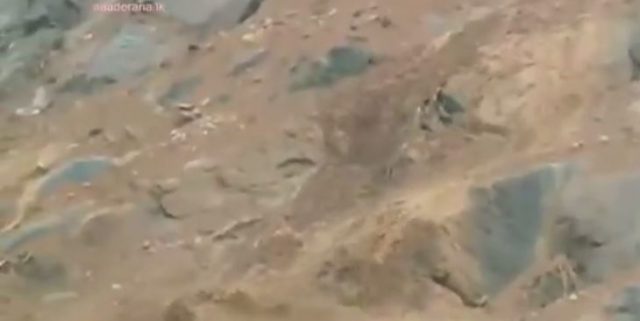
The mobility of the Aranayake landslide
An technically interesting aspect of the Aranayake landslide tragedy in Sri Lanka is the high levels of mobility that the debris has obviously shown. It is this mobility that has allowed the debris to travel so far, and of course so fast, which in combination is the reasons for so many fatalities. A video has been posted on Youtube showing a very small secondary failure of the landslide mass:
.
This failure is only a few cubic metres, a minute fraction of the devastating landslide of earlier this week. But its behaviour illustrates the problem beautifully. At the start of the video the failure is clearly just a standard small-scale landslide:
Still from a Youtube video of a secondary failure at the Aranayake landslide site
.
However, this quickly transitions into a highly fluid, very mobile mass:
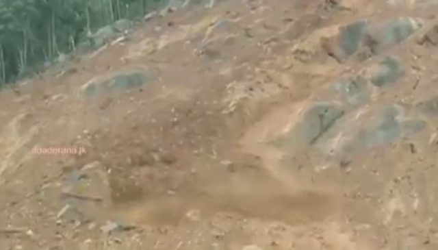
A still from the Aranyake landslide video showing the highly mobile landslide mass
.
One can only imagine what this must have looked like when the whole slope was on the move.
The Sri Lankan army today ceased its operations to rescue landslide victims, and instead turned to a recovery and relief mission. However, in a deeply surreal move, Nepal has reportedly donated $100,000 dollars towards “relief operations in the disaster zones”. Whilst the desire to assist a neighbour in distress is commendable, Nepal has many, many people living in the aftermath of an earthquake without any tangible assistance, and with the monsoon looming. There is reportedly a huge amount of unspent relief money, intended to assist the victims of the earthquake, so far unspent. This must surely be the priority for Nepal? Whilst the Aranayake landslide, and associated damage, is a disaster in Sri Lanka, the impacts are a fraction of those in the rural areas of Nepal. This should be the priority for the Nepal Government.
 Dave Petley is the Vice-Chancellor of the University of Hull in the United Kingdom. His blog provides commentary and analysis of landslide events occurring worldwide, including the landslides themselves, latest research, and conferences and meetings.
Recent Comments