
18 April 2016
Landslides from the Kumamoto earthquake in Japan
Posted by Dave Petley
Landslides from the Kumamoto earthquake in Japan
The Kumamoto earthquake, the second of the two significant earthquakes that Japan over the last three days, and the associated aftershocks, appears to have generated significant numbers of landslides. Experience tells us that the area most affected by earthquake-induced landslides will be the terrain with significant slopes that has a high concentration of aftershocks. The largest landslide seems to be a very substantial slope failure close to Mimami-Aso that destroyed an important bridge. Asia One has a quite beautiful image of this landslide:
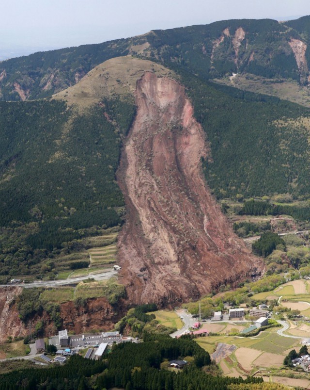
A landslide triggered by the Kumamoto earthquake, via Asia One
.
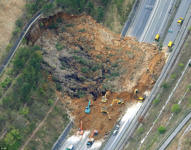
This appears to be a large rockslide in weathered rock. Note that the crown extends almost to the ridge, which is common in earthquake induced landslides. This landslide must have deposited a large volume of material in the gorge. Note also that the other slopes along the gorge have failed too, as this AP image shows. There is a reasonably large landslide towards the left side of the image that has come close to destroying another bridge:
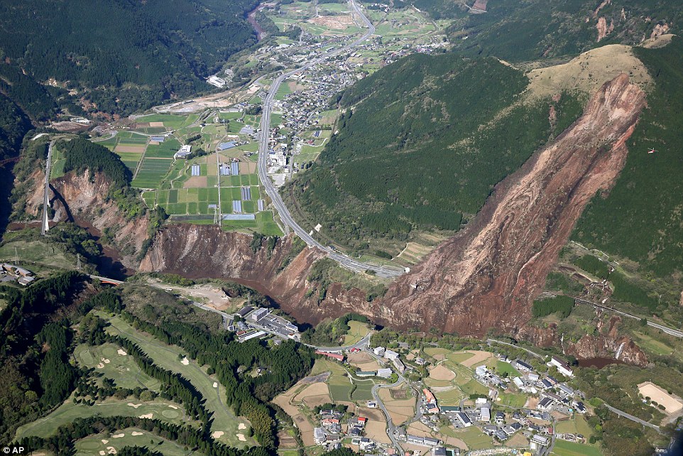
A landslide triggered bu the Kumamoto earthquake, via AP
.
However, this is by no means the only landslide. AFP have an image of a landslide that appears to have caused serious damage to the Kurowa Dai-ichi power station:
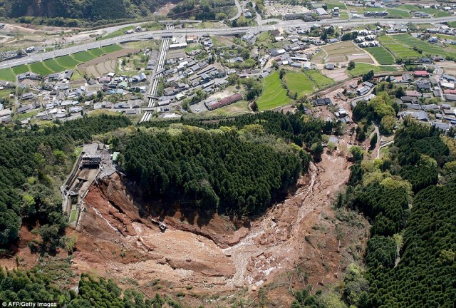
Damage to the Kurokawa Dai-ichi Power Station caused by the Kumamoto earthquake, via AFP
.
There are also some images of a quite peculiar and deeply intriguing flowslide. AP have this image of the debris in the fields:
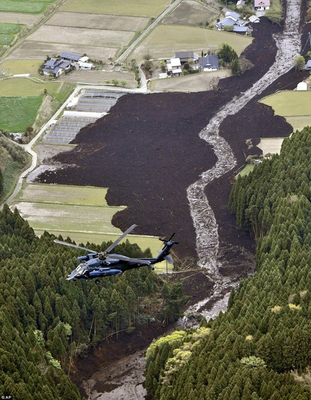
A flowslide triggered by the Kumamoto earthquake, via AP
.
Whilst the BBC has some nice video footage of it. There seems to be quite a large amount of landslide damage to roads. This appears to be a major cutslope failure:
A major cutslope failure on the Oita Expressway, triggered by the Kumamoto Earthquake, via AP
.
Other road damage seems to have been caused by the failure of fill slopes:
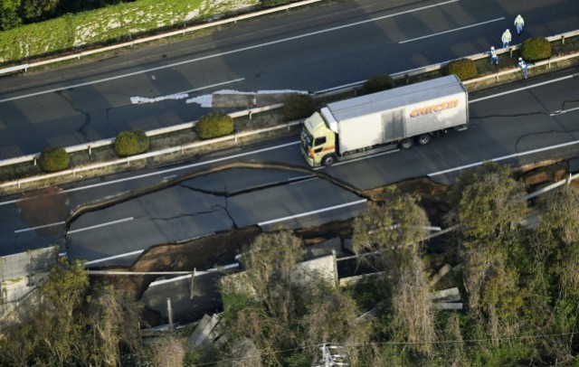
Road damage caused by the Kumomata earthquake via Asia One
.
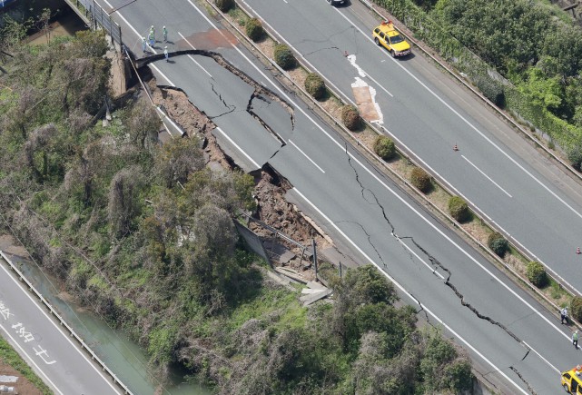
Highway damage caused by the Kumomata Earthquake, via Asia One
.
If you have links to further images please post them in the comments.
 Dave Petley is the Vice-Chancellor of the University of Hull in the United Kingdom. His blog provides commentary and analysis of landslide events occurring worldwide, including the landslides themselves, latest research, and conferences and meetings.
My name is Kenichi HANDA.
I was dispatched to National Building Research Organization (NBRO) in Sri Lanka from Ministry of Land, Infrastructure, Transport and Tourism in Japan.
NBRO is an organization investigating a landslide disaster of Sri Lanka.
Now I have been in NBRO as JICA (Japan International Cooperation Agency) Expert and Chief Advisor of ‘Technical Cooperation for Landslide Mitigation Project’.
I got the information of the WEB site about the Kumamoto earthquake from Japan.
The following URLs are the Web sites where aerial photos about the Kumamoto earthquake are published in.
Sorry, all web site is written by Japanese.
But I think that you can understand what kind of phenomenons happen, if you watch the photograph in that web site.
FYI
# GSI(Geographical Survey Institute) web site
http://www.gsi.go.jp/BOUSAI/H27-kumamoto-earthquake-index.html#aa
Click “UAV” above the each photographs, so you can watch the movie taken by UAV(drone)
4 photographs show from the top,
1st is landslide(collapse & debris flow) in Minami-Aso village
2nd is the “Minami Aso Oohasi” bridge which was destroyed by a landslide
3rd is the earthquake faults on the surface in Minami-Aso village
4th is the earthquake faults on the surface in Mashiki town
# PASCO CORPORATION (PVT)
http://www.pasco.co.jp/disaster_info/160415/#n06
# KOKUSAI KOGYO CO., LTD.
http://www.kkc.co.jp/service/bousai/csr/disaster/201604_kumamoto/index.html#anc0416
# ASIA AIR SURVEY CO., LTD.
http://www.ajiko.co.jp/article/detail/ID56EDF7EZH/