
30 December 2016
Jharkhand and Hpakant: two deadly mine waste landslides in the last two days
Jharkhand and Hpakant: two deadly mine waste landslides in the last two days
In the last two days there have been two deadly mine waste landslides, in Jharkhand in India and Hpakant in Burma (Myanmar), killing substantial numbers of people:-
A mine waste landslide at Jharkhand, India
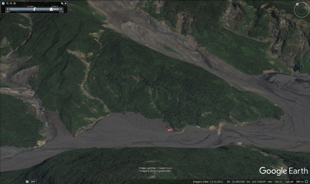
News reports indicate that a substantial landslide occurred at the Rajmahal coal mine in Godda district, Jharkhand at 7:30 pm local time on 29th December. The reports and image indicate that this was a large landslide in a waste pile that covered a number of excavators and other machines working at the pit bottom. The number of people buried is slightly unclear, but the best estimate appears to be about 22. At the time of writing nine bodies have been recovered. The likelihood of survivors appears to be remote.
There are several images of the landslide on various news reports, although none provides a decent perspective as yet. The best image I have found is this one:-
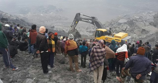
The coal mine landslide at Jharkhand, India on 29th December. Image from Manob Chowdhury via scroll.in
.
Yet another deadly Jade mine landslide in Hpakant, Burma
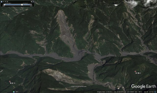
Meanwhile, the deadly toll of mine waste landslides in Burma continues, an issue that I have described with depressing regularity over the last two years. Yet again a large dump collapsed, burying at least 20 people, on 28th December. Vietnam Plus has a brief report with a photograph of the site:
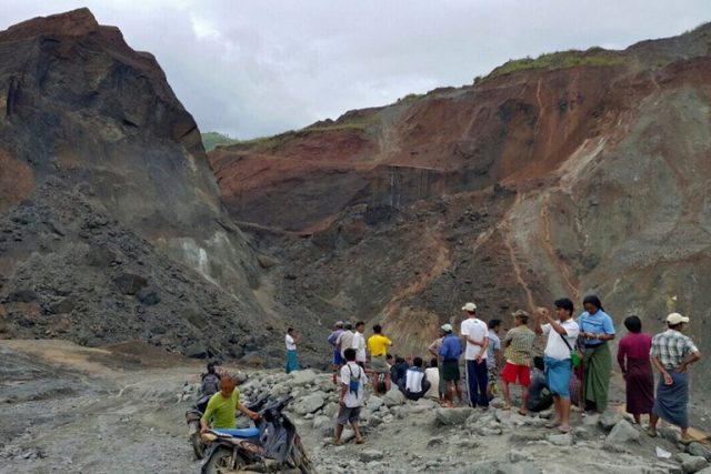
The site of a landslide at a jade mine in Kachin State, Myanmar (Photo via Vietnam Plus and the New York Times)
.
As I have noted in my recent article in New Civil Engineer, we have both the knowledge and the skills to avoid these types of landslides from causing loss of life. In developed countries mine waste landslides do occur occasionally, but rarely cause deaths (although an exception might be tailings dam failures). That these landslides wreak such havoc in poor countries remains a scandal.
Previous post about the depressing toll of mine waste landslides in Burma:
- Who was to blame for the Hpakant jade mine landslide?
- Hpakant – another serious Jade Mine landslide in Burma
- Mining in Burma and hydroelectric power in China: two major landslides with familiar causes this weekend
- Burma jade mine landslides: an annus horribilis
- Pharkant, Burma: a liquefaction landslide in mine tailings (with a stunning video)
- Disastrous mining related landslide in Burma / Myanmar
27 December 2016
The Safeland project reports on landslide hazard and risk management
The Safeland Project reports
The Safeland project reports
Safeland was an EU funded project that ran from 2010 to 2012 that sought to develop quantitative risk assessment and management tools and strategies for landslides across Europe at a range of scales. Coordinated by the NGI in Norway and including a glittering cast of landslide research organisations from across Europe, it was a highly successful collaborative programme. I do not think there has been a project like it before or after. Whilst the project is now complete, the research continues to have a significant impact.
One of the legacies of Safeland is a set of project reports that are singularly impressive documents for the most-part. Sadly, for some time these were not available online as the original Safeland project site was hacked. I am delighted to say though that a new portal has been established, and all of these reports are available for download once more.
This is the full set of reports with embedded links to the PDF document:
Work Area 1:
Improving knowledge on landslide hazard (triggering and run-out models)
Deliverable 1.1: Landslide triggering mechanisms in Europe – Overview and State of the Art
Deliverable 1.2: Geomechanical modelling of slope deformation and failure processes driven by climatic factors: shallow landslides, deep landslides and debris flows
Deliverable 1.4: Guidelines for use of numerical codes for prediction of climate-induced landslides
Deliverable 1.5: Statistical and empirical models for prediction of precipitation-induced landslides
Deliverable 1.6: Analysis of landslides triggered by anthropogenic factors in Europe
Deliverable 1.8: Guidelines: recommended models of landslide triggering processes and run-out to be used in QRA
Deliverable 1.9: Recommendations for run out models for use in landslide hazard and risk mapping
Work Area 2:
Quantitative risk assessment (QRA)
Deliverable 2.1: Overview of landslide hazard and risk assessment practices
Deliverable 2.2a: Examples of international practice in landslide hazard and risk mapping. Assessing the state of art of landslide hazard and risk assessment in the P.R. of China
Deliverable 2.2b: Harmonisation and development of procedures for quantifying landslide hazard
Deliverable 2.3: Overview of European landslide databases and recommendations for interoperability and harmonisation of landslide databases
Deliverable 2.4: Guidelines for landslide susceptibility, hazard and risk assessment and zoning
Deliverable 2.5: Physical vulnerability of elements at risk to landslides: Methodology for evaluation, fragility curves and damage states for buildings and lifelines
Deliverable 2.6: Methodology for evaluation of the socio-economic impact of landslides (socio-economic vulnerability)
Deliverable 2.7a: Case studies of environmental and societal impact of landslides – Part A: Rev. Case studies for environmental (physical) vulnerability
Deliverable 2.7b: Case studies of environmental and societal impact of landslides – Part B: Case studies for socio-economic vulnerability
Deliverable 2.8: Recommended Procedures for Validating Landslide Hazard and Risk Models and Maps
Deliverable 2.9: Toolbox for landslide quantitative risks assessment
Deliverable 2.10: Identification of landslide hazard and risk “hotspots” in Europe
Deliverable 2.11: QRA case studies at selected “hotspots”. Synthesis of critical issues
Work Area 3:
Quantying global change scenarios (climatic and anthropogenic) and their impact on landslide hazard and risk in the future
Deliverable 3.2: REMO climate change simulations with 10km horizontal resolution for case study sites in Southern Italy, the Alps, Southern Norway, and Romania
Deliverable 3.3: Analysis of selected extreme precipitation events with the COSMO-CLM model on a spatial scale of 2.8 km
Deliverable 3.5: Overview and interpretation of available data and information on human activity and demographic evolution
Deliverable 3.7: Expected changes in climate-driven landslide activity (magnitude, frequency) in Europe in the next 100 years
Work Area 4:
Development of monitoring technology, especially early warning systems and remote sensing techniques, and applications
Deliverable 4.1: Review of Techniques for Landslide Detection, Fast Characterization, Rapid Mapping and Long-Term Monitoring
Deliverable 4.2: Short-term weather forecasting for shallow landslide prediction – Methodology, evaluation of technologies and validation at selected test sites
Deliverable 4.3: Creation and updating of landslide inventory maps, landslide deformation maps and hazard maps as input for QRA using remote-sensing technology
Deliverable 4.4: Guidelines for the selection of appropriate remote sensing technologies for monitoring different types of landslides
Deliverable 4.5: Evaluation report on innovative monitoring and remote sensing methods and future technology
Deliverable 4.6: Report on evaluation of mass movement indicators
Deliverable 4.7: Report on the development of software for early warning based on real-time data
Deliverable 4.8: Guidelines for landslide monitoring and early warning systems in Europe – Design and required technology
Work Area 5:
Risk management, including toolbox or appropriate hazard and risk mitigation measures and stakeholder process for risk management
Deliverable 5.1: Compendium of tested and innovative structural, non-structural and risk-transfer mitigation measures for different landslide types
Deliverable 5.2: Toolbox of landslide mitigation measures
Deliverable 5.3: Quantitative risk-cost-benefit analysis of selected mitigation options for two case studies
Deliverable 5.4: Quantification of uncertainties in the risk assessment and management process
Deliverable 5.6: Development and testing of spatial multi-criteria evaluation for selected case sites
Deliverable 5.7: Design and testing: a risk communication strategy and a deliberative process for choosing a set of mitigation and prevention measures
Work Package 6:
Demonstration sites and case studies for verification/calibration of models and scenarios
Deliverable 6.1: Validation form and monograph of monitored sites and case studies
Work Package 8:
Project management and co-ordination
Deliverable 0.1: Living with landslides – European and international dimensions of the project
Deliverable 0.3: Dealing with uncertainties in modelling, prediction, and decision-making
23 December 2016
Jiuhaocha in Pingtung County – more on the impacts of landslides on a mountain village
Jiuhaocha in Pingtung County – more on the impacts of landslides on a mountain village
Yesterday I blogged about the massive impacts of landslides and associated river-borne sediment on the village of Jiuhaocha in Pingtung County, Taiwan. In fact the element that I posted yesterday was only a small part of the story. C-Y Chen has a blog in Mandarin that describes landslide disasters in Taiwan – I hadn’t come across this before but it is very interesting (Google translate does a good enough job to make it readable without difficulty). Back in April he posted an article about the landslide problem in Jiuhaocha, which provides a very interesting description of the long term problem.
The history goes back to 1979 when the village was established as a “model village” on the river terrace. This of course explains the very organised structure of the community, with its grid-like street pattern, as shown in this Panaramio photo from 2009:
Panaramio image of Jiuhaocha village in Pingtung County from 2009
.
Th landslide story starts in 1996, when the area was struck by Typhoon Herb. I was in eastern Taiwan at that time – this event came close to killing me (but that is a story for another day) – but the village was very badly affected by landslides. In particular a slide near to the church (which is the large building with a red roof on the right side of the centre of the image above) crashed into the village, killing four people. C-Y Chen has an image of this landslide:
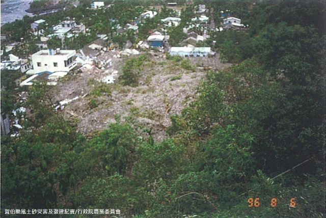
The 1996 landslide that struck Jiuhaocha in Pingtung County, via C-Y Chen
.
In 2003 a report by the National Cheng Kung University recognised the landslide dangers in this village, and also highlighted the risk of flooding from the river in extreme rainfall scenarios. By 2005 the river was rapidly aggrading (i.e.the river bed was rising as sediment accumulated) because of the landslides located upstream of the village. This was increasing the risk of a flood related disaster at Jiuhaocha. Heavy rainfall events in 2006 and 2007 saw further landslide activity in the area around the Jiuhaocha, meaning that some of the houses became partially buried in debris. C-Y Chen has this image of the damage:-
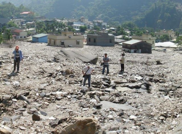
Landslide damage in 2007 Juihaocha, Pingtung County, via C-Y Chen
.
And then in 2009 Typhoon Morakot brought 1,900 mm of rainfall to Pingtung County, during which Jiuhaocha was completely buried, leaving only the church standing. By this time the river bed had aggraded by a staggering 40 metres as a result of the landslides upstream. The church is the one building that can be seen in the Google Earth image at that time:-
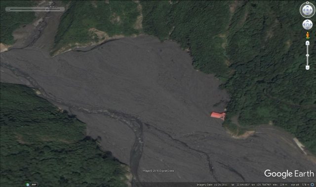
Google Earth image showing the church to be the only building standing in Jiuhaocha in 2009
22 December 2016
Jiuhaocha: an example of the extraordinarily dynamic landscape of Taiwan
Jiuhaocha: the extraordinarily dynamic landscape of Taiwan
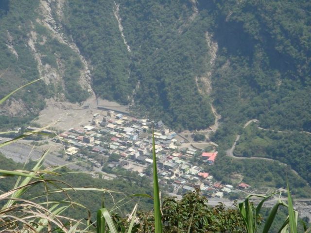
I was looking at Google Earth imagery of Taiwan this week. In the early part of my career I spent a great deal of time there – Taiwan is a wonderful country in every respect, but from my perspective the extraordinarily dynamic landscape has always been a fascination. As you are probably aware, in 2009 the southern part of Taiwan was struck by a terrible tropical cyclone – Typhoon Morakot – that triggered many thousands of landslides. One of these, at Shiaolin Village, killed several hundred people. However, I was looking at a different site – the village of Jiuhaocha – a little to the south. This is a satellite image of a small village – I count about 50 houses and other buildings – in the mountains. The image below was taken in 2001. Mountain villages in Taiwan are often the home to comparatively poor, indigenous Taiwanese people and/or the families of ex-servicemen who became farmers when Taiwan was settled after the Maoist uprising in mainland China. Jiuhaocha is a village of the Rukai aboriginal people. The settlement was located within the mountains of Pingtung County in southern Taiwan. The Rukai people are one of the 14 recognized aboriginal tribes of Taiwan:
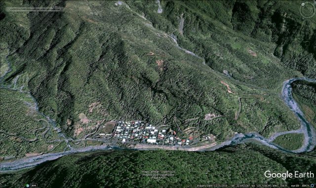
Google Earth image of the small mountain village of Jouhaocha in Taiwan
.
Jiuhaocha has a long and complex history. But this is an area that was hit very hard by Typhoon Morakot. This storm that caused the following to happen – this is an image of the same location in 2011:
Google Earth image from 2011 of Jiuhaocha village in southern Taiwan
.
The difference is undeniably shocking. In this case the village has been buried by sediment carried by the river in flood. But the source of this sediment was the multiple landslides triggered by the storm upstream of the village, some of which were very large:
Google Earth imagery of the multiple landslides in Taiwan
.
Fortunately the population of Jiuhaocha were evacuated before the typhoon, so no lives were lost. But the risks to populations located in the mountains of a dynamic environment such as Taiwan are very clear.
21 December 2016
The Folkestone Warren landslide toe weight structure
The Folkestone Warren landslide toe weight structure
On the South Coast of England the railway line between Dover (the main ferry port for travel to Europe) and London crosses a very large landslide at Folkestone Warren in Kent. This is a large (3 km wide), deep-seated (the shear surface extends about 40 m below sea level) rotational landslide. The track crosses the entire width of the landslide, located on displaced blocks, as this BGS image shows:
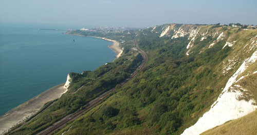
The Folkestone Warren landslide, image from the BGS taken in 2002
.
Unsurprisingly this railway line has a very long history of being disrupted by the landslide. The most famous incident occurred on 19 December 1915, when 1.5 million cubic metres of chalk slipped, causing enormous damage to the line. A train was caught in the landslide, but fortunately without any loss of life:
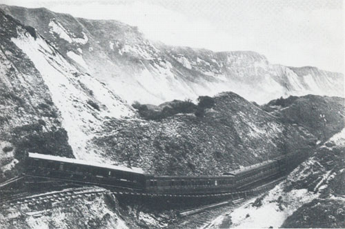
The 1915 landslide on Folkestone Warren, from British Railways, Southern Division via the BGS)
.
The line was closed until 1919. The slope remained active thereafter – this Google Earth image from 1940 gives a good impression of the magnitude of the problems that British Railways faced at that time:-
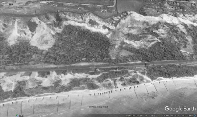
Google Earth image of the Folkestone Warren landslide from 1940
.
In 1948 an enormous toe weight structure, designed to add mass to the toe of the landslide to prevent further rotational failures, was constructed. This was extended between 1951 and 1952. There is a very nice article (N.B. this is a PDF), published in the Railway Magazine, on the Southern Railway E-mail Group (SREmG) site describing these works, and the associated drainage tunnels. This vast, and effective, toe weight can be seen in the modern Google Earth images as a platform built at the toe of the landslide:-
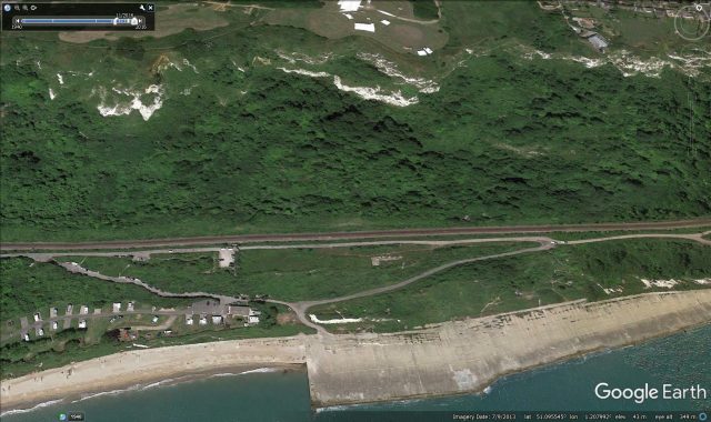
Google Earth image of the Folketsone Warren toe weight structure
.
The effectiveness of these and the associated landslide management measures is clear from the above image – the slide is much less active now than it has been in the past. But nonetheless this remains a deeply challenging section of railway line for Network Rail to maintain.
19 December 2016
Big French Creek: a high quality new landslide video
Big French Creek: a high quality new landslide video
KRCRTV featured last week a very nice new landslide video of a collapse that occurred on Highway 299W at Big French Creek in California. The landslide happened last Monday (12th December 2017) at about 1 pm. As you will see from the video the road was closed. The video was captured by Kevin Erwin. It is a great catch in that it records the minute or so leading up to the failure, as well as the movement of the large boulder that is located within the weather rock mass. Kevin loaded the video onto Youtube, so it can be sen below:
.
The same event was also captured by J2R2J:
.
Jack Irving kindly highlighted this video to me. He has identified the location as 40.779, -123.311, which looks like this on Google Maps:
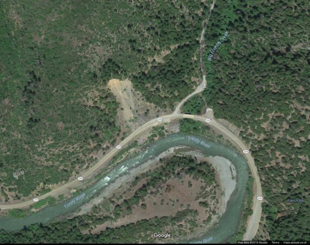
The landslide at Big French Creek via Google Maps
.
The presence of work crews suggests that the highway agency were aware that the slope was problematic, and it is clear that the road had been closed prior to the collapse. Latest news from Caltrans is that the road is still closed:
SR 299
    [IN THE NORTHERN CALIFORNIA AREA]
    IS CLOSED 4.5 MI WEST OF BIG BAR /AT BIG FRENCH CREEK/ (TRINITY CO) 24 HRS
A DAY 7 DAYS A WEEK THRU THE WEEK OF 01/08/17 - MOTORISTS ARE ADVISED TO USE AN
ALTERNATE ROUTE
Renewed problems at Pacifica
Meanwhile Pasi Jokela has kindly highlighted a renewed problem at Pacifica to the south of San Francisco, where coastal erosion is causing increasing problems for a coastal community. Liveleak has a nice drone video of a “sinkhole” that has appeared on the cliff. This is a fill slope located behind a sea wall – it seems on first inspection that the fill has washed out:
.
The video also highlights a number of other properties that are at a high level of risk from erosion. NBC Bay Area has a decent report about the problem. I have previously featured the ongoing problems at Pacifica, including another very nice drone video of the site.
15 December 2016
On the difference between prediction and foresight in landslide hazard assessment
The runout of large landslides can rarely be predicted, but the potential behaviour can still be foreseen
On the difference between prediction and foresight in landslide hazard assessment
In one of the landslide sessions at the AGU Fall Meeting yesterday one of the speakers made an interesting comment about his perception of over-confidence of landslide experts in the prediction of landslide behaviour. The comment was made in the context of landslide runout, which is highly dependent on initial conditions. The point that was made is that, given these conditions are not known in advance, it is impossible to predict with any confidence the behaviour of many landslides. I agree.
However, this does not mean that it is impossible to foresee the behaviour of a potential landslide. For something to be foreseeable does not require exact prediction of its behaviour. Foresight means anticipation of a potential outcome – this is in essence a risk-based approach, and it is entirely possible in almost all cases for landslides.
Let me illustrate my point through a hypothetical example. Let’s imagine a slope in a mountain valley that has undergone several previous phases of movement, none of which have had a long runout but all of which have been substantial. There is a discussion as to whether to allow the construction of houses on the land in the valley below the landslide – should development be permitted or not? There are two elements to the assessment of the hazard posed by the landslide – first, can the landslide reactivate once more? And second, could it run out onto the land in which the houses are being planned?
Assessment of the likelihood of reactivation is quite straightforward, and based on the previous history of failures is likely to conclude that this is possible. In our imaginary example all parties agree that a further failure could occur. Analysis of the potential runout is much harder due to the problems outlined above. One approach is to model, but that is difficult given the dependence on initial conditions, the possible volume of the mobilised mass, etc. But there is an alternative, which is to look for similar landslides in similar materials, and to determine how they have behaved. This is particularly useful if they are located in the vicinity of the landslide in question. If they show long runout then there is the potential that the landslide in question might also show a high mobility, and thus pose a risk to the houses.
In our hypothetical example a brief examination of slopes in the local area suggests that some have displayed high mobility.
Thus, in this case long runout / high mobility behaviour is not predictable but it is foreseeable. Given the vulnerability of the people in the houses, a reasonable approach would be to prevent development even if the likelihood of high mobility of the landslide was comparatively low. This is a risk-based approach; it is common across the spectrum of natural hazards and it does not require that exact predictions of behaviour are made.
14 December 2016
Progressive Rock Failure – a meeting in Switzerland in June 2017

The flyer for the Progressive Rock Failure symposium in June 2017
Progressive Rock Failure – a meeting in Switzerland in June 2017
One of the most interesting types of landslide are those driven by progressive rock failure. These landslides tend to show long periods of creep deformation that, in some cases, transitions into a paid failure event. Not all landslides go through this transition though, which means that hazard analysis for these failures is a problem. It is also clear that these failures may occur (and indeed often do occur) without a trigger, meaning that their behaviour can be quite hard to manage. However, there is also some evidence that at least some show characteristic patterns of acceleration before final collapse, which can be used to predict failure. Opinions differ as to the drivers for these processes. There are also uncertainties as to what underpins the changes in behaviour that these landslides exhibit – is there for example a critical strain at which failure begins? and if so, what determines this parameter?
These issues are important not just for landslides. Progressive rock failure may be a key issue in tunnels, boreholes and mines. Thus there is a great deal to learn from getting together a diverse range of people interested in progressive rock failure, from both the academic and the applied field.
ETH Zurich has decided to arrange such a meeting, which will be held from 5th to 8th June 2017. Pre-registration for this meeting is currently open. Details of this meeting are available at the Symposium Website. In my view this is likely to be a great meeting – highly focused with a group of really top people in the field. This sort of meeting is the perfect complement to the mighty AGU Fall Meeting. I fully intend to be there.
Oh, and the setting looks rather cool too!
The setting of the Progressive Rock Failure seminar in June 2017.
13 December 2016
Landslides caused by the 1929 M=7.8 Murchison earthquake in New Zealand
Landslides caused by the 1929 M=7.8 Murchison earthquake in New Zealand
Whilst there is a strong focus in New Zealand at the moment on the multiple landslides triggered by the Kaikoura earthquake last month, GNS Science have released a new report about the landslides triggered by the 1929 M=7.9 Murchison earthquake on the other side of South island. This was a major event that probably triggered even more landslides than the most recent earthquake. The report details the collation and analysis of a full inventory of the landslides triggered by the earthquake, based upon mapping from aerial photographs, supplemented with other sources of data. Because the primary source of information is a set of images collected in 1968, the inventory is only for larger landslides (those with a surface area grater than 2500 square metres). Nonetheless there are 5356 landslides in the inventory extending over an area of about 16,000 square kilometres.
Some of the statistics are impressive – the earthquake triggered two landslides with a volume of more than 100 million cubic metres, and there are 42 valley blocking landslides (landslide dams) in the dataset. Several of these landslide dams breached catastrophically over the weeks following the earthquake. As a result there was extensive flooding and damage in the towns of Seddonville, Little Wanganui and Karamea. In total 14 people were killed by landslides, and two miners died in mine collapse events triggered by the shaking.
To give an idea of the extent of the landsliding triggered by the Murchison Earthquake, the report includes this twin oblique and vertical pair of images of an area of landslides in the Karamea Valley:
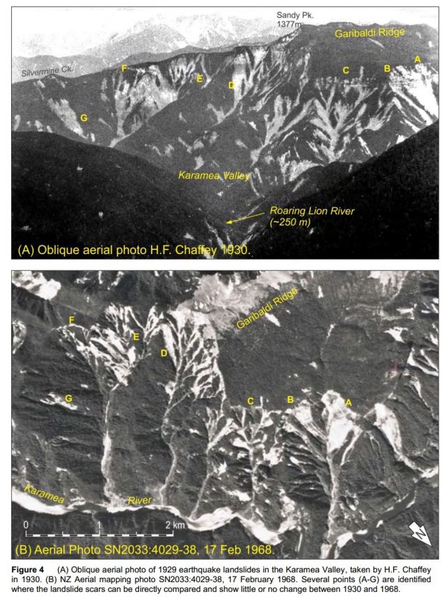
Landslide triggered by the 1929 Murchison Earthquake. From the new GNS Science Report
.
Some of the large landslides are truly impressive. This is the 18 million cubic metre Lake Stanley rock avalanche, some 85 km from the epicentre for example:
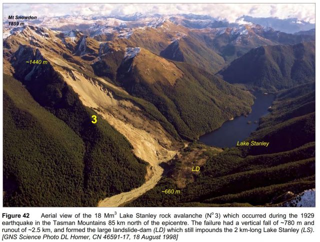
The Lake Stanley rock avalanche triggered by the 1929 Murchison Earthquake in New Zealand, from the new GNS Science report.
.
At the first AGU landslides session tomorrow (which will be streamed live), one of the authors, Brenda Rosser, will be describing the New Zealand landslide dataset compiled by GNS Science.
Reference
Hancox, G.T., Ries, W.F., Parker, R.N., Rosser, B., 2015. Landslides caused by the MS 7.8 Murchison earthquake of 17 June 1929 in northwest South Island, New Zealand. GNS Science Report 2015/42. pp127 (2 Volumes)
12 December 2016
AGU 16: live stream of the first landslide session on Wednesday

Scientists admire the the carpet design inside the Moscone Centre at AGU 16
AGU 16: live stream of the first landslide session on Wednesday
This week is AGU 16 – the Fall Meeting of the American Geophysical Union in San Francisco. As usual it is an amazing, stimulating and slightly intimidating event. This is science on a grand scale both in terms of the projects themselves and the number of attendees. Last year the meeting attracted almost 24,000 attendees. This year feels just as busy, perhaps more so.
The main landslide event occurs on Wednesday and Thursday, with two oral sessions on the former and an epic poster session on the latter. The AGU have decided to live stream the first of the two landslide sessions. This is at 8 am local time (which is 4 pm in the UK) and runs for two hours. I have the honour of kicking the session off – many thanks to the convenors for the very kind invitation to do this. Below are the details of the session and the list of talks:
Wednesday, 14 December 2016, 08:00 – 10:00 am
Moscone South – 102
Primary Convener: Dalia Kirschbaum
Conveners: Paola Reichenbach and Hiroshi Fukuoka
Papers
08:00: NH31B-01 The global landslide distribution in the 2015-16 El Nino event (Invited). David N Petley and Melanie Froude
08:15: NH31B-02 New Zealand’s National Landslide Database. Brenda Rosser, Sally Dellow, Soren Haubrook and Phil Glassey
08:30: NH31B-03 Hydrological Evaluation of Precipitation Intensity-Duration Thresholds for Regional Landslide Hazard Assessment. Thom Bogaard and Roberto Greco
08:45: NH31B-04 Extreme Events in the tropics – Hurricane Manuel and La Pintada Landslide. M. Teresa Ramirez-Herrera and Krzysztof Gaidzik
09:00: NH31B-05 Landslide Susceptibility Mapping of Tegucigalpa, Honduras Using Artificial Neural Network, Bayesian Network and Decision Trees. Elias Leonardo Garcia Urquia, Anika Braun, and Hiromitsu Yamagishi.
09:15: NH31B-06 Regional Landslide Hazard Assessment Considering Potential Climate Change. Susana Almeida, Elizabeth Holcombe, Francesca Pianosi and Thorsten Wagener
09:30: NH31B-07 Spatiotemporal Patterns and Risks of Rainfall-Triggered Landslides across Conterminous United States Inferred from Satellite Observations and Model Simulations. Ke Zhang, Yang Hong and Jonathan J Gourley
09:45: NH31B-08 Considerations about the mechanism and mitigation plan of rainfall-induced landslide after The 2016 Kumamoto Earthquake (Invited). Naoki Sakai.
There are some excellent topics there, so it promises to be a most-interesting session. You can join it for free by registering for AGU On Demand. There isn’t an option to ask questions remotely, but if anyone is interested we could discuss the session using #AGU16 and #NH31B in real time (though you will have to start without me for obvious reasons!

It appears that one can even play Pokemon Go inside the Moscone at AGU 16
 Dave Petley is the Vice-Chancellor of the University of Hull in the United Kingdom. His blog provides commentary and analysis of landslide events occurring worldwide, including the landslides themselves, latest research, and conferences and meetings.
Recent Comments