
22 January 2017
Nanzhang County, Hubei: 12 killed as a hotel is crushed by a rockslope failure
Nanzhang County, Hubei: 12 killed as a hotel is crushed by a rockslope failure
On Friday night a major rockslope failure occurred on a steep slope behind the Mirage Hotel in the Haishishenlou holiday village, in Nanzhang County, Hubei, China. The hotel was crushed; 12 people, including the owner, were killed in the dining room. There were three survivors (whilst two of the victims died after being rescued). Xinhua reports today that the remains of all of the victims have been recovered.
There are a range of images available of the event, most of which focus on the rescue operation. The one that best depicts the circumstances is this one, via Xinhua:
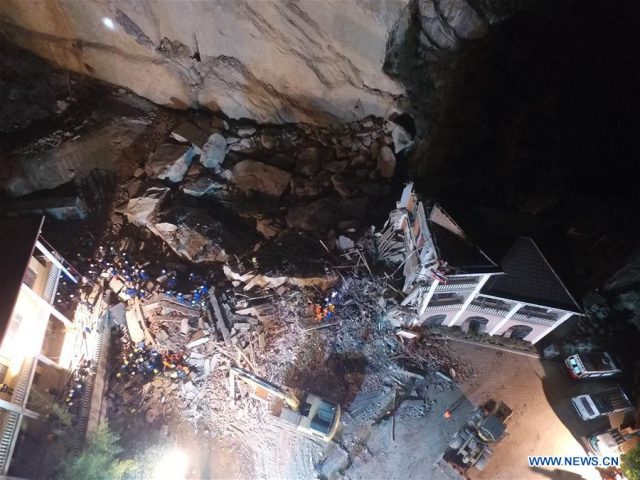
The aftermath of the landslide in Nanzhang County, Hubei, China on Friday, via Xinhua.
.
Based on the above this appears to be a massive rockslope failure – reports suggest 3000 cubic metres – that has fallen directly onto the building. The reports suggest that the largest blocks were 150 tonnes, but I would suspect based on the image that this may be an underestimate.
The slope behind the hotel is interesting. Whilst the scar of the rockfall is not clear from this image – the blocks may have come from higher up the slope – the vertical discontinuities (joints) in the mass are clear both immediately behind the hotel and in the adjacent slopes. These provide a ready-made release surface for the rockfall. We would normally expect that a good site investigation would be able to determine the hazard posed by these joints, but I cannot comment on what happened here.
Interestingly, there is no suggestion of a trigger in the news reports, although the images of the rescuers do suggest that they are dressing for cold (but possibly not very cold) weather. The reports also indicate that there were real concerns about the potential for further failures on the slope.
21 January 2017
Xekaman 3 hydroelectric plant in Laos: a very major landslide in December
Xekaman 3 hydroelectric plant in Laos: a very major landslide in December
The Xekaman 3 hydroelectric power station in Laos is a 250 MW dam, tunnel and associated infrastructure located at 15.375N 107.407E, close to the border with Vietnam. Built between 2006 and 2010 at a cost of US$273 million, 90% of the electricity generated is exported to Vietnam. Fairly soon after completion the dam started to be plagues by landslide problems, not at the dam site but at the penstock, which it appears was constructed on an ancient landslide without adequate measures being taken to provide stability. There is a nice paper providing details of the landslide affecting the Xekaman 3 penstock online here (NB this is a PDF).
Problems appear to have started soon after the reservoir was filled, and the paper reports multiple movement events, mostly with reasonably small displacements, that caused major damage to the penstock and associated pipelines. At one location it appears that a sinkhole has opened up, and there is also a reference to a new channel being formed. The paper notes that work was ongoing to try to solve the landslide problem; in the meantime a telescopic section of pipe was installed into the pipeline to try to accommodate movement. The paper includes the photograph below of the site. Note the re-engineered walls and structures. Note also the red-roofed powerhouse at the toe of the slope – this is a key structure in the most recent event:
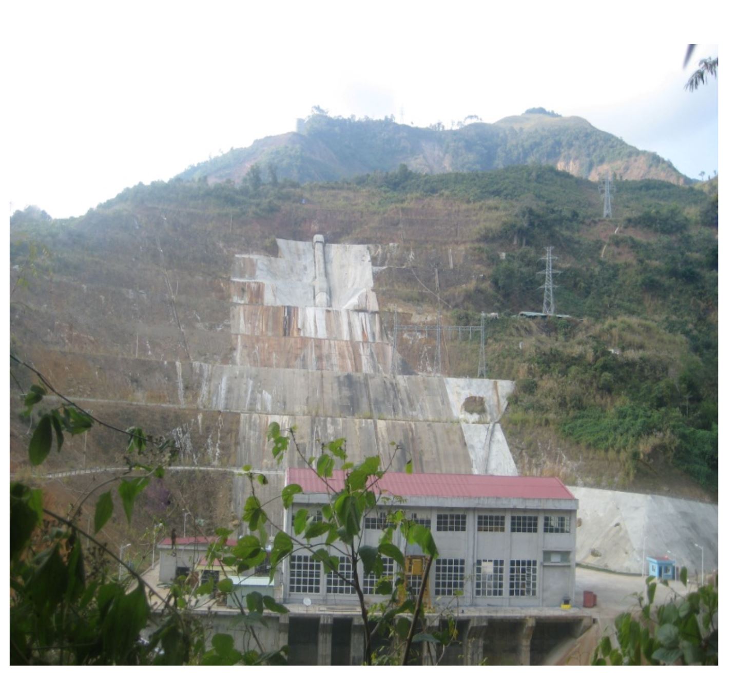
The penstock site for the Xekaman 3 HEP station, via the ISRM
.
At 8:45 am on 16th December a major failure occurred on this slope, which has destroyed the penstock infrastructure. Radio Free Asia has a report about the landslide, which states that:
A break in a critical waterway shut down a hydro-electric dam in southern Laos and raised questions about the quality of construction at the facility that sends most of the power it generates to Vietnam. While officials said the Dec. 16 break in the Xekaman 3 facility’s penstock posed no threat to people living downstream, it marked the second breakdown in the tunnel that channels water to the power turbine, RFA’s Lao Service has learned.
“The broken portion of the pipe is about 100 meters from the power house,” said an official who spoke on condition of anonymity. “Rocks and mud flowed into the power house.”
According to the official, the damage is extensive as the power house and its equipment were inundated.
“The dam is no longer operational,” the official told RFA’s Lao Service. “Power production is stopped.”
Perhaps the most interesting element though is a photograph of the site, also in the report:

The aftermath of the 16th December landslide at Xekaman 3, via Radio Free Asia. Photograph by Kamphon
.
The almost completely buried building is the power house at the toe of the slope. This was clearly an exceptionally serious, and expensive, landslide.
I have written both here and in a paper about the evidence that many of the major hydroelectric schemes under construction across Asia are taking inadequate consideration of landslides. This event reinforces my view. I continue to fear that we are heading for a tragedy.
18 January 2017
The Mount Sulzer avalanches: the amazing video
The Mount Sulzer avalanches: the amazing video
Yesterday I posted details of the four Mount Sulzer avalanches in Wrangell-St. Elias National Park and Preserve in Alaska. Information about these landslides was provided by Mike Loso – he can be contacted at the following email address:- [email protected] . I noted that he had kindly sent to me a video of the fourth of these events, shot from the air by Luke Wassink, a National Park Service Ranger. Luke and Mike have given permission for me to make this video available via Youtube, so I have uploaded it this morning. The video, which is remarkable, should be accessible here, and I have embedded it below:
.
I very much appreciate the help and support of Michael and Luke in making this available. The video is remarkable, not least because of the incredible power of the flow. But note that this event was tiny compared with the two largest events. Compare the deposit in this image with the trim lines left by the earlier flows in the image below, taken from the video:
Still from the video of one of the Mount Sulzer avalanches, by Luke Wassink. Mote the trimlines that show how large the earlier events must have been
.
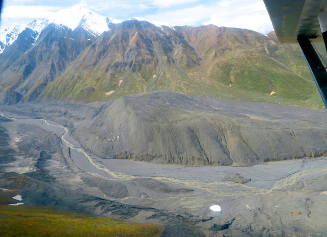
The materials involved in these Mount Sulzer avalanches is a complex mix of ice and debris. This image, taken by Mike Loso, shows the aftermath of the August 2016 event:-
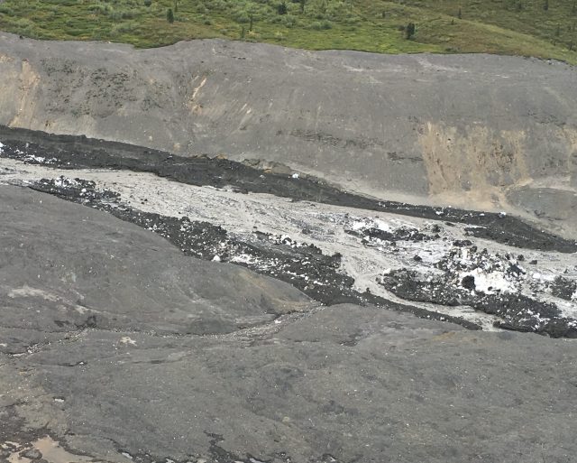
The aftermath of the August 2016 Mount Sulzer avalanche showing the complex mix of materials. Image by Mike Loso.
.
This type of landslide is poorly studied because of the difficulties in obtaining good data. The video is a remarkable addition to the portfolio of information about these slides. It will now be very interesting to see if further Mount Sulzer avalanches occur in the coming summer.
Acknowledgements
Once again I would like to thanks Mike Loso and Luke Wassink of Wrangell-St. Elias National Park and Preserve in Alaska for making this material available.
17 January 2017
Mount Sulzer – a series of dramatic, and extremely large, debris and ice avalanches
Mount Sulzer debris and ice avalanches
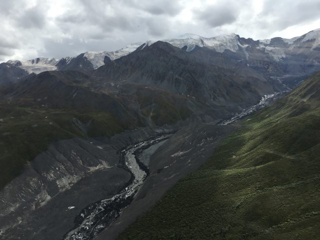
Mike Loso (contact via: [email protected]) of Wrangell-St. Elias National Park and Preserve in Alaska has kindly provided details of an amazing series of debris and ice avalanches that have descended from the flanks of Mount Sulzer in recent years. The Google Earth image below shows the location. On the left is the site of these major landslides. The next valley to the west (on the right in this image) has also suffered a glacier surge in the 2015-16 period, but that is not the focus here.
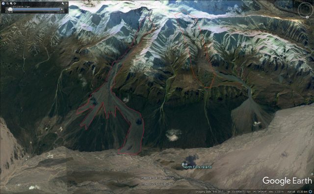
Google Earth image of the Mount Sulzer debris and ice avalanches
.
In the couple of years before summer 2015 this site appears to have suffered at least two major debris and ice avalanche events. The image below, the earliest in this sequence (from summer 2015) shows the aftermath of these flows:
An image of Mount Sulzer from Summer 2015 showing the remarkable trim line caused by an earlier landslide events. Image by Jeff Trop.
.
A landslide deposit is very clear in the foreground, but note the removal of vegetation on the substantial hill on the inside of the bend in the river, including the creation of a clear trim line marking the edge of the flow as it crossed the topography. The very obvious deposit in the foreground, shown below, does not appear to be the major landslide that caused this trim line; this appears to be a second, smaller, event that is sitting on the sheet-like deposit of the larger first landslide:
The deposit left by the second Mount Sulzer landslide, sitting on top of the earlier event. Image by Jeff Trop.
.
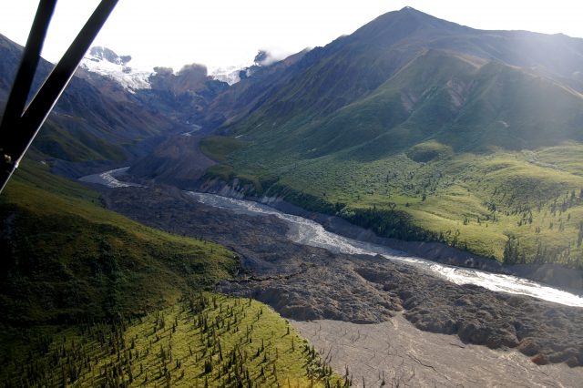
Later in summer 2015 there was a further (the third in this sequence) very large landslide event. This appears to have run over the hill in the foreground once more, removing even more of the vegetation:
Aerial shot of the aftermath of the summer 2015 landslide on Mount Sulzer. Image by Paul Claus
.
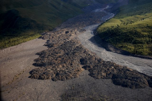
Then in summer 2016 a further slide occurred. This landslide, which happened on 13th August 2016, was observed and videoed by one of the rangers. This video is now online. The image below shows the aftermath of the landslide:
The aftermath of the August 2016 Mount Sulzer landslide, with remains of the flow in the channel (image by Michael Loso)
.
The source of these landslides is a steep glacier terminus that is clearly capable of discharges large ice-avalanches, but that also contains evidence of strongly altered, likely clay and ice-rich, unstable slopes beneath the active glacier face:
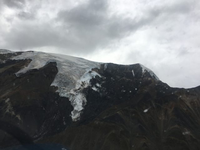
The steep hanging glacier source of the Mount Sulzer landslides. Image by Mike Loso.
.
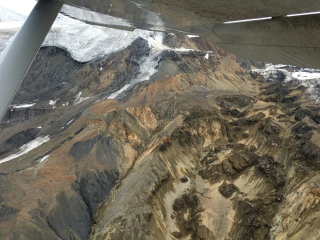
Ice-rich, highly altered sediments that represent the source of much of the debris for the Mount Sulzer landslides. Image by Mike Loso.
.
Once again the incredibly dynamic landslide environment of the mountains of Alaska is clear. Over the last three years it is become apparent that this area is the most active on Earth in terms of very large landslides. That was not expected (by me at least).
Many thanks to Mike Loso ([email protected]) for providing this information, and to various others for the images.
16 January 2017
Future shock – the failure to learn from the 2015 earthquake in Nepal
Future Shock: The exceptional vulnerability of buildings in Nepal to a future earthquake
Future shock – the failure to learn from the 2015 earthquake in Nepal
The Nepali Times had a large piece over the weekend entitled Future Shock, which was driven by National Earthquake day in Nepal. In an accompanying editorial, the newspaper notes the disastrous failure of Nepal to learn lessons from the earthquake, noting that:
In Kathmandu Valley, the earthquake damage convinced many that cement buildings are safer. A stronger earthquake that lasted longer would have pancaked most concrete structures on 25 April 2015. As our special report in this edition points out, scientists have warned of much more catastrophic earthquakes in the vicinity of Kathmandu Valley and in Western Nepal. Existing and new buildings are just not capable of withstanding the intensity of shaking we are bound to experience in the Central Himalaya at any time.
And, most importantly:
We do not intend to spread panic, but the sad fact is that Nepal has squandered the lessons of 2015, and we are woefully unprepared for a disaster sure to come. This doesn’t just mean rehabilitating structures that came down two years ago, but also retrofitting buildings in western Nepal where a Big One is imminent.
The delayed and ineffective response to 2015 and the lack of serious preparedness is a result of a larger failure of governance. As our report shows, the whole corrupt building permit process has to be overhauled so that safety comes before revenue. We cannot afford to wait for the politics to fix itself, our greatest concern now should be on pre-disaster preparedness and to learn from past experiences.
In my opinion, this hits the nail on the head. The earthquake left many unstable slopes, and many exceptionally vulnerable people, in the mountainous areas to the north of Kathmandu. There was an almost total lack of government-led preparedness for the 2016 monsoon, despite warnings that the situation was highly dangerous. Since then, progress has been slow, even though the 2017 monsoon is just months away. It is hard not to believe that Nepal is heading for an even greater disaster.
The full set of Future Shock articles – they are all worth a read:
- ‘Not out of danger yet’, Sonia Awale
- Stirred, not shaken, Kunda Dixit
- Cashing in on politics, Shreejana Shrestha
- A concrete future, Sonia Awale
- A month that felt like a year, Kunda Dixit
- Preparing to be prepared, Kunda Dixit
12 January 2017
Volcan, Argentina: massive mudflows cause major disruption
Volcan, Argentina: massive mudflows cause major disruption
Heavy rainfall in the extreme northwest of Argentina, close to the border with Chile, has caused major mudflows over the last few days. Whilst the focus in the media has been on the disruption to the Dakar Rally, the impact on local people has been far more serious, especially in the town of Volcan. Two fatalities have been reported.
Reuters has a nice image of the level of destruction caused by one of the landslides, which has affected the margins of the town:
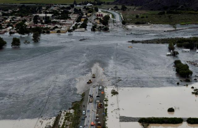
One of the landslides on the margin of the town of Volcan in Argentina, via Reuters
.
Meanwhile AP has a view from a different perspective:
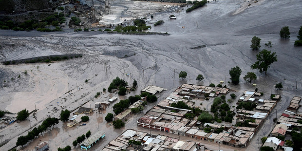
The level of damage caused by the landslides at Volcan in Argentina, via AP
.
The AP report indicates that there were at least two major landslides, affecting the towns of Volcan and Tumbaya, which lies a little to the north. These appear to be highly mobile mudflows in very fine-grained materials, similar to lahars. There is a major volcanic province reasonabley close to this area of the Andes, but I have not been able to ascertain whether this region consists of volcanic deposits (the name of the town is of course interesting in this respect). About 1000 people have needed to be relocated.
A quick view of the Google Earth imagery for this area suggests that these are not the first landslides to affect Volcan by any means:
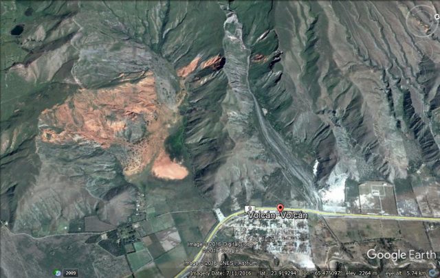
Google earth imagery of the town of Volcan. Note north is to the right of the image.
.
There are some pretty interesting landslides in this image. The event of the last few days appears to have come down to the valley to the north of the town (on the right side in the image above). The location of the town makes it vulnerable to these high mobility flows.
11 January 2017
The 1906 Haverstraw landslide
The 1906 Haverstraw landslide
This week marked the 111th anniversary of the disastrous Haverstraw landslide in Rockland County, New York, which killed 19 people. The disaster was caused by the folly of humans, chasing wealth to be made from the excavation of glacial blue clay, ideal for brick making. At the height of the industry there were an estimated 3,000 labourers making 350 million bricks per year in Haverstraw. Over time the quarries opened to exploit the clay moved closer to the town, and excavation was also undertaken in tunnels that ran beneath the settlement. There is some evidence that local people were raising concerns about the potential for landslides, but of course these were dismissed.
On 8th January 1906 an existing large crack, which had appeared a couple of years earlier, on Rockland Street started to widen. Some concern was raised, and it does appear that many people left their homes, but others reportedly stoked their coal fires and retired to bed.
The first landslide occurred at 11 pm, when of course it would have been dark and many would have been asleep. The landslide damaged a number of houses, but also started fires as stoves and lamps were upset. This was followed by a second landslide at 11:20 pm, and a final one at 11:31 pm. Several fires developed, but it proved difficult to fight them due to the cold temperatures and the loss of pressure in the pipes as they ruptured in the landslide. As noted above, 19 people lost their lives. Three of the bodies were not recovered.
In total about six blocks of the town, including 21 buildings, were lost. There are some amazing photographs of the aftermath of the disaster. The Rockland Times has a nice article that includes some of them, including this one:
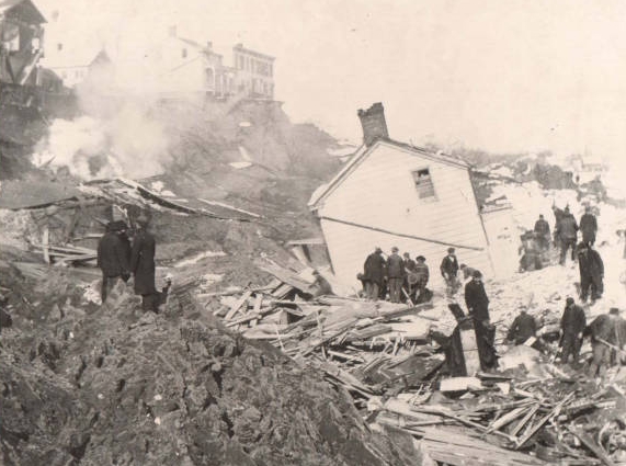
The aftermath of the 1906 Haverstraw landslide, via the Rockland Times
.
This postcard from the time provides a remarkable overview of the damage across the town:
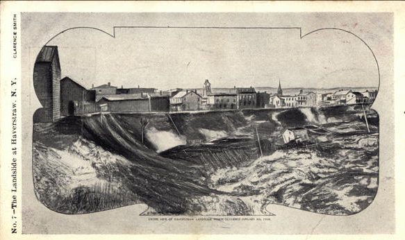
A postcard providing a view of Landslide Haverstraw, NY
.
Today the town has of course been rebuilt, but the Google Earth image shows the extraordinary landslide scar:
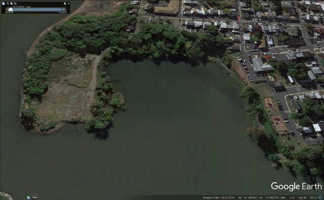
Google Earth image showing the scar of the 1906 Haverstraw landslide
.
Haverstraw Library has a nice web page of resources providing reports and detail about the Haverstraw landslide, whilst Brick Collecting has a good newspaper article about the event.
9 January 2017
Naxal, Kathmandu: a landslide apparently caused by poor construction management
Naxal, Kathmandu: a landslide caused by poor construction management
At 7 am yesterday morning a section of the Bhagwati Bahal-Bal Mandir road in Naxal, Kathmandu collapsed into a deep excavation, closing this busy highway. Ekantipur has the best image of the site that I have seen so far:
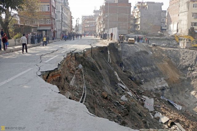
The collapsed road section in Naxal, Kathmandu, via eKantipur
.
The site is an excavation for a new 5 star hotel, provisionally planned to be Hilton Doubletree. The Kathmandu Post has a good description of the situation:
The crumbling of the road section between Bhagwati Bahal Temple and Bal Mandir, an orphanage, swallowed up one lane of the street, opening a cavity measuring around 25 meters deep, according to the Department of Roads.
“The developers had dug a big hole around two to three storeys deep to lay the foundation of the proposed hotel. Use of heavy equipment too played a catalytic role in causing the accident,” Roads Department Spokesperson Dayakanta Jha said.
The damage caused to the road segment severely affected vehicular movement in area throughout Sunday. The department has said it would take at least two to three days to repair the segment.
A preliminary assessment carried out by Roads Department officials revealed that the incident occurred “despite taking proper precautionary measures”. “Pile foundation, which is required for such construction, is right in place,” Jha said.
The last statement is decidedly odd. I question whether the issue here is pile foundations; the problem is more likely to be with the retaining structure on the margin of the excavation. There are many techniques to allow this to be conducted safely; in this case something has clearly not worked as planned.
An example of what is possible appeared on Twitter last night, this is apparently the excavation for a new hotel from Iran:
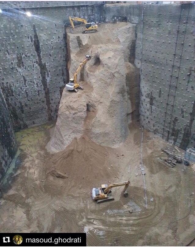
An excavation for a new hotel in Iran, via Twitter
6 January 2017
Collapsing Arctic coastlines
Collapsing Arctic coastlines
In a commentary just published in Nature Climate Change, Michael Fritz from the Helmholtz Centre for Polar and Marine Research in Potsdam, and colleagues, have highlighted the potential physical and socioeconomic impacts of the collapse of coastlines in the Arctic. The article has also been covered in a piece published today in the International Business Times, which is accompanied by some startling images of the coastal landslides that are a primary mechanism for this loss of land:
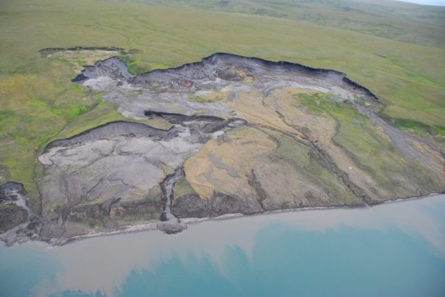
The eroding coastlines of the Arctic – image by Michael Krautblatter via IBT
.
The article highlights that the materials that form these Arctic coastlines consist primarily of thick, organic-rich permafrost (frozen soils). The rate of erosion of these coastlines has increased dramatically as global warming drives an increasing impact in high latitude areas. The effects are a triple whammy on arctic coastlines, as noted by Fritz et al. (2017):
Fluxes from coastal erosion are expected to drastically increase due to the combined effect of declining summer sea-ice cover on the Arctic Ocean, longer and warmer thawing seasons, and the rising sea level allowing waves to hit the coast higher and longer during the ice-free season.
The upshot is rates of erosion that can reach 25 metres per year, as shown in the image below, and huge increases in the rate of organic release.
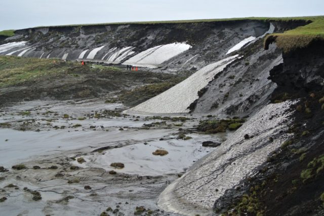
A landslide on Herschel Island, illustrating the rate of loss of Arctic coastlines. Image by Boris Radosavljevic via IBT
.
Fritz et al. (2017) note that the impact of such large releases of carbon to the local and global environment are poorly understood, and urge an increased research effort to understand these processes. They note that these landslides that are causing such rapid degradation of Arctic coastlines are likely to have impacts on Arctic marine biodiversity, food security of high latitude people and cultural heritage. These impacts are being seen across the Arctic – 34% of the Earth’s coasts consist of permafrost soils – so the need for increased understanding is clear.
Reference
Fritz, M., Vonk, J.E. and Lantuit, H. 2017. Collapsing Arctic Coastlines. Nature Climate Change, 7, 6–7, doi:10.1038/nclimate3188
Other posts about the impacts of rapid climate change in the high latitudes
- The catastrophic loss of Arctic Sea Ice and its implications for landslides
- The Icy Bay landslide in Alaska: a nice video describing the link with glacial melting
- Slumps caused by thawing ground on Mars and Earth
1 January 2017
Tumpat-Kuala Lipis: A landslide induced train derailment in Malaysia
Tumpat-Kuala Lipis: A landslide induced train derailment in Malaysia
Heavy rainfall in Malaysia over the last few days has triggered at least nine landslides on the Tumpat-Kuala Lipis railway line in Malaysia. The line will be closed for at least a week. One of these landslides derailed a train, fortunately travelling at a low speed. The 1Malaynews blog has a report in Malay, although as ever Google Translate does a fine job:
…commenting on the landslide that resulted in an intercity train from Tumpat to Kuala Lipis derailed this morning, Zaid said the incident occurred near Station Kuala Gris, Dabong.
“The train departed from Tumpat station at 4.30am heading to Kuala Lipis. When arriving in a tunnel, the train driver noticed landslides and stopped the train. However, while reversing the train, sudden landslides and struck the train, causing it to slide off the track,” he said. He said, however, that all 33 passengers and 4 crew were unhurt. “All the passengers and 4 crew was then walk 2 kilometers to Kuala Gris Station before being transferred by bus to Dabong Station.
The same site has a couple of images of the incident and the landslides:
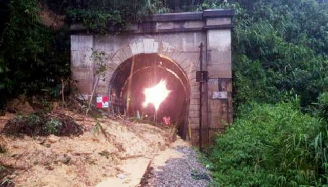
One of the landslides on the Tumpat-Kuala Lipis railway line, via the 1Malaynews blog
.
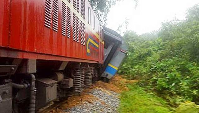
The derailed train on the Tumpat-Kuala Lipis railway line in Malaysia, via the 1MalayNews blog
.
Examples of other landslides on railway lines
- The Folkestone Warren landslide toe weight structure
- Landslide-induced train accident in China
- The location of the Italian train crash landslide
- Images of yesterday’s landslide-induced train incidents
- The train derailment on the West Highland line on Thursday
- Unbelievable – a video of a landslide striking and derailing a freight train in Everett, near Seattle, USA
 Dave Petley is the Vice-Chancellor of the University of Hull in the United Kingdom. His blog provides commentary and analysis of landslide events occurring worldwide, including the landslides themselves, latest research, and conferences and meetings.
Recent Comments