
27 December 2016
The Safeland project reports on landslide hazard and risk management
Posted by Dave Petley
The Safeland Project reports
The Safeland project reports
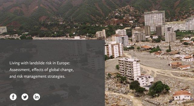
Safeland was an EU funded project that ran from 2010 to 2012 that sought to develop quantitative risk assessment and management tools and strategies for landslides across Europe at a range of scales. Coordinated by the NGI in Norway and including a glittering cast of landslide research organisations from across Europe, it was a highly successful collaborative programme. I do not think there has been a project like it before or after. Whilst the project is now complete, the research continues to have a significant impact.
One of the legacies of Safeland is a set of project reports that are singularly impressive documents for the most-part. Sadly, for some time these were not available online as the original Safeland project site was hacked. I am delighted to say though that a new portal has been established, and all of these reports are available for download once more.
This is the full set of reports with embedded links to the PDF document:
Work Area 1:
Improving knowledge on landslide hazard (triggering and run-out models)
Deliverable 1.1: Landslide triggering mechanisms in Europe – Overview and State of the Art
Deliverable 1.2: Geomechanical modelling of slope deformation and failure processes driven by climatic factors: shallow landslides, deep landslides and debris flows
Deliverable 1.4: Guidelines for use of numerical codes for prediction of climate-induced landslides
Deliverable 1.5: Statistical and empirical models for prediction of precipitation-induced landslides
Deliverable 1.6: Analysis of landslides triggered by anthropogenic factors in Europe
Deliverable 1.8: Guidelines: recommended models of landslide triggering processes and run-out to be used in QRA
Deliverable 1.9: Recommendations for run out models for use in landslide hazard and risk mapping
Work Area 2:
Quantitative risk assessment (QRA)
Deliverable 2.1: Overview of landslide hazard and risk assessment practices
Deliverable 2.2a: Examples of international practice in landslide hazard and risk mapping. Assessing the state of art of landslide hazard and risk assessment in the P.R. of China
Deliverable 2.2b: Harmonisation and development of procedures for quantifying landslide hazard
Deliverable 2.3: Overview of European landslide databases and recommendations for interoperability and harmonisation of landslide databases
Deliverable 2.4: Guidelines for landslide susceptibility, hazard and risk assessment and zoning
Deliverable 2.5: Physical vulnerability of elements at risk to landslides: Methodology for evaluation, fragility curves and damage states for buildings and lifelines
Deliverable 2.6: Methodology for evaluation of the socio-economic impact of landslides (socio-economic vulnerability)
Deliverable 2.7a: Case studies of environmental and societal impact of landslides – Part A: Rev. Case studies for environmental (physical) vulnerability
Deliverable 2.7b: Case studies of environmental and societal impact of landslides – Part B: Case studies for socio-economic vulnerability
Deliverable 2.8: Recommended Procedures for Validating Landslide Hazard and Risk Models and Maps
Deliverable 2.9: Toolbox for landslide quantitative risks assessment
Deliverable 2.10: Identification of landslide hazard and risk “hotspots” in Europe
Deliverable 2.11: QRA case studies at selected “hotspots”. Synthesis of critical issues
Work Area 3:
Quantying global change scenarios (climatic and anthropogenic) and their impact on landslide hazard and risk in the future
Deliverable 3.2: REMO climate change simulations with 10km horizontal resolution for case study sites in Southern Italy, the Alps, Southern Norway, and Romania
Deliverable 3.3: Analysis of selected extreme precipitation events with the COSMO-CLM model on a spatial scale of 2.8 km
Deliverable 3.5: Overview and interpretation of available data and information on human activity and demographic evolution
Deliverable 3.7: Expected changes in climate-driven landslide activity (magnitude, frequency) in Europe in the next 100 years
Work Area 4:
Development of monitoring technology, especially early warning systems and remote sensing techniques, and applications
Deliverable 4.1: Review of Techniques for Landslide Detection, Fast Characterization, Rapid Mapping and Long-Term Monitoring
Deliverable 4.2: Short-term weather forecasting for shallow landslide prediction – Methodology, evaluation of technologies and validation at selected test sites
Deliverable 4.3: Creation and updating of landslide inventory maps, landslide deformation maps and hazard maps as input for QRA using remote-sensing technology
Deliverable 4.4: Guidelines for the selection of appropriate remote sensing technologies for monitoring different types of landslides
Deliverable 4.5: Evaluation report on innovative monitoring and remote sensing methods and future technology
Deliverable 4.6: Report on evaluation of mass movement indicators
Deliverable 4.7: Report on the development of software for early warning based on real-time data
Deliverable 4.8: Guidelines for landslide monitoring and early warning systems in Europe – Design and required technology
Work Area 5:
Risk management, including toolbox or appropriate hazard and risk mitigation measures and stakeholder process for risk management
Deliverable 5.1: Compendium of tested and innovative structural, non-structural and risk-transfer mitigation measures for different landslide types
Deliverable 5.2: Toolbox of landslide mitigation measures
Deliverable 5.3: Quantitative risk-cost-benefit analysis of selected mitigation options for two case studies
Deliverable 5.4: Quantification of uncertainties in the risk assessment and management process
Deliverable 5.6: Development and testing of spatial multi-criteria evaluation for selected case sites
Deliverable 5.7: Design and testing: a risk communication strategy and a deliberative process for choosing a set of mitigation and prevention measures
Work Package 6:
Demonstration sites and case studies for verification/calibration of models and scenarios
Deliverable 6.1: Validation form and monograph of monitored sites and case studies
Work Package 8:
Project management and co-ordination
Deliverable 0.1: Living with landslides – European and international dimensions of the project
Deliverable 0.3: Dealing with uncertainties in modelling, prediction, and decision-making
 Dave Petley is the Vice-Chancellor of the University of Hull in the United Kingdom. His blog provides commentary and analysis of landslide events occurring worldwide, including the landslides themselves, latest research, and conferences and meetings.