
21 June 2023
Post-failure Planet image of the Brienz-Brinzauls landslide
Post-failure Planet image of the Brienz-Brinzauls landslide
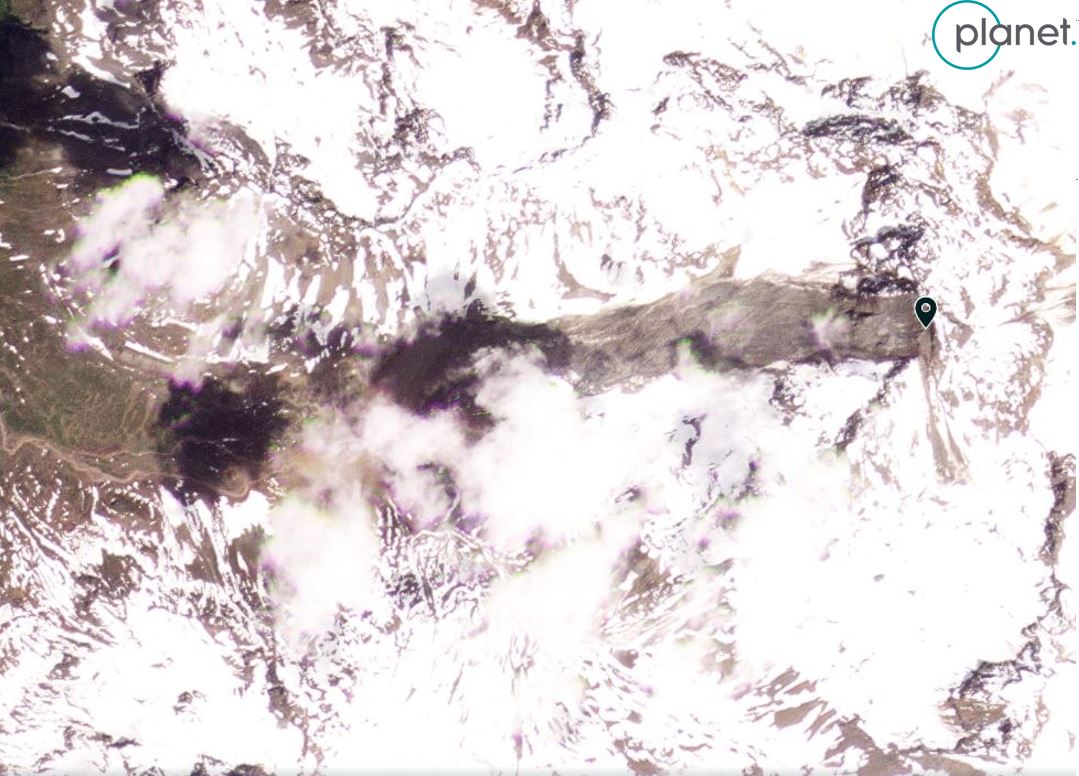
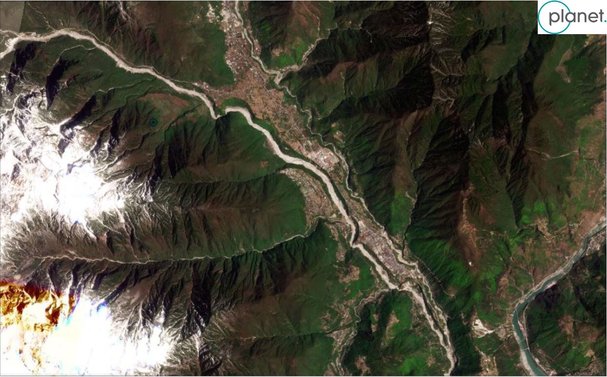
The major failure at Brienz-Brinzauls on 15 June 2023 has attracted considerable attention. The landslide occurred at 23:38 local time on 15 June. Initial estimates are that about 1.2 million cubic metres of rock detached, with a shear surface that is about 50 m deep. The peak velocity is estimated to have been 80 km/h.
Planet has captured a high resolution satellite image of the aftermath of the landslide:-
The aftermath of the 15/16 June 2023 landslide, as captured by a high resolution Planet SkySat instrument. Image copyright Planet, used with permission.
.
As the image demonstrates, the lower part of the main path of the landslide did not flow towards the village, and the mass stopped short of the houses. Thus, Brienz-Brinzauls is essentially undamaged.
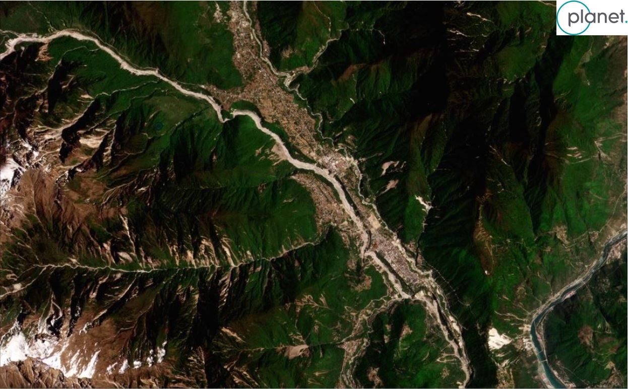
The slider below should allow you to compare the before and after Planet Skysat images:-
As the image above shows, the main detachment is from the central part of the slope – this is the area known as The Island. There is limited loss of mass at the crown of the landslide. Runout distance appears to be quite modest for a landslide on this scale, probably because of the topography.
It is well documented that Brienz-Brinzauls is located on an area of the slope that has been actively deforming, albeit at rates that are much more modest than had been the case upslope. A fascinating element of the dynamics of the landslide will be to see how this lower slope now responds to the main failure. This is quite difficult to predict without a detailed understanding of the dynamics of the landslide complex. Work will also be needed to ensure that the landslide debris itself is stable, especially in the event of heavy rainfall. Hopefully, the village will be safe to reoccupy.
Overall, this is a good outcome for Brienz-Brinzauls.
.
Reference and acknowledgement
Many thanks to my friends at Planet for another stunning image.
Planet Team (2023). Planet Application Program Interface: In Space for Life on Earth. San Francisco, CA. https://www.planet.com/
20 June 2023
The 30 June 2022 Tupul, Manipur landslide in India
The 30 June 2022 Tupul, Manipur landslide in India
On 20 June 2022, a large landslide occurred at Makhuam village, which is located in the Tupul District of Manipur in NE India [approximate location is [24.8389, 93.6276]. The landslide killed 61 people, the majority of whom were staff from the adjacent railway construction site and local people. A further 18 people were injured.
At the time of the landslide I posted an initial interpretation of the events, speculating on the basis of the landslide deposit and scar that there were two distinct phases of movement, and that failure was associated with the construction of the railway through the area.
A paper has now been published in the journal Landslides (Baruah et al. 2023) that provides an initial interpretation of this appalling landslide. This provides a proper analysis of the events. The image below, from the paper, provides an annotated interpretation of the landslide:-
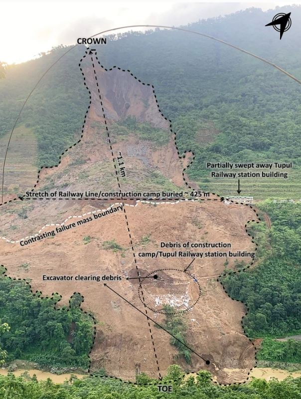
Annotated image of the 30 June 2022 Tupul, Manipur landslide in India. Image from Baruah et al. (2023).
.
Baruah et al. (2023) confirm that the landslide occurred in two distinct phases, the first at 12:30 am local time, and the second at 6 am. Given that many of the victims were located in a dormitory that was destroyed by the landslide, the timing of the first (larger) phase is particularly important (and unfortunate). The authors note that “a preliminary assessment by the Geological Survey of India (GSI) highlighted extensive slope cutting for the construction of the railway station” was the primary cause of the landslide. The authors also note that May and June 2022 were unusually wet, recording a total of 705.5 mm of rainfall, which is 130% higher than the mean total for these two months over the previous decade.
Thus it seems that this landslide was the classic combination of poorly designed or implemented slope excavation coupled with heavy rainfall. It once again serves to highlight the many issues at present in the development of transportation corridors in in the Himalayas in India.
.
Reference
Baruah, S., Dey, C. & Sanoujam, M. Preliminary account on the 30th June 2022 Tupul, Manipur landslide of Northeast India. Landslides (2023). https://doi.org/10.1007/s10346-023-02074-y
19 June 2023
An update on the 11 June 2023 Flüchthorn rock avalanche
An update on the 11 June 2023 Flüchthorn rock avalanche
Land Tirol has published (in German) some information about the 11 June 2023 Flüchthorn rock avalanche in Austria. Most interestingly, they have collected aerial laser scanning of the mountain, which has allowed an estimate to be made of the volume of the landslide, which is reckoned to be 1 million cubic metres. There ae two particularly interesting graphics. First, one highlighting the volume of rock that has been lost:-
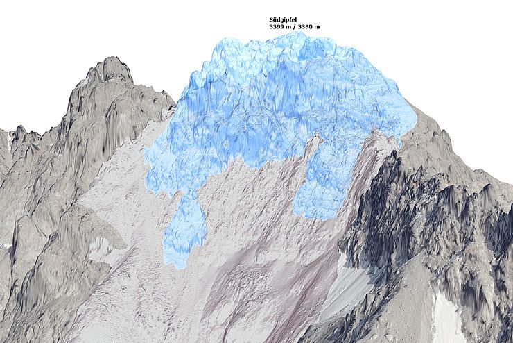
A reconstruction using laser scan data of the volume lost in the 11 June 2023 Flüchthorn rock avalanche in Austria. Image copyright State of Tyrol, via Land Tirol.
.
Second is an initial cross-section, also using the laser scan data, showing the change in topography:-
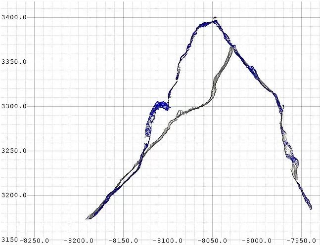
A cross-section using laser scan data showing the volume lost in the 11 June 2023 Flüchthorn rock avalanche in Austria. Image copyright State of Tyrol, via Land Tirol.
.
The southern peak of the mountain has reduced in elevation by 19 m, from 3,399 m to 3,380 m, and the mountain top has been displaced laterally by about 30 m. This event is unusual, but not unique, in cleaving through the summit in this way.
The best image that I have seen of the whole of the landslide has been released by Land Tirol:-
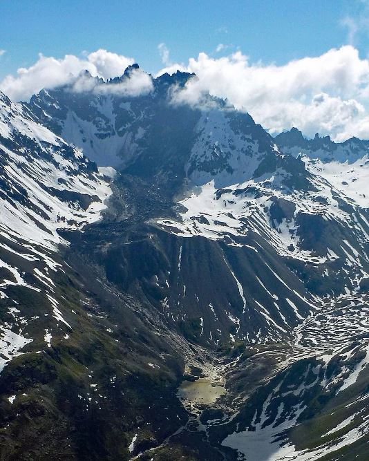
The entire track of the 11 June 2023 Flüchthorn rock avalanche in Austria. Image copyright State of Tyrol, via Land Tirol.
.
Note the very steep initial fall of the landslide, then the runout over a terrace, before a steep descent into the lake. There will undoubtedly be modelling undertaken of this event, which will be published in due course. It is very fortunate that there was no-one in the path of this major rock avalanche.
Finally, Micha Dietz has published some further seismic analyses of the event, which is worth reading. It is interesting to see how different stations captured different elements of the seismic signal generated by this landslide.
16 June 2023
A major landslide at Brienz-Brinzauls
A major landslide at Brienz-Brinzauls
Overnight on 15/16 June 2023, a major landslide has occurred at Brienz-Brinzauls. The picture this morning shows that a very large mass has slipped, covering much of the area up to the Blick webcam:-
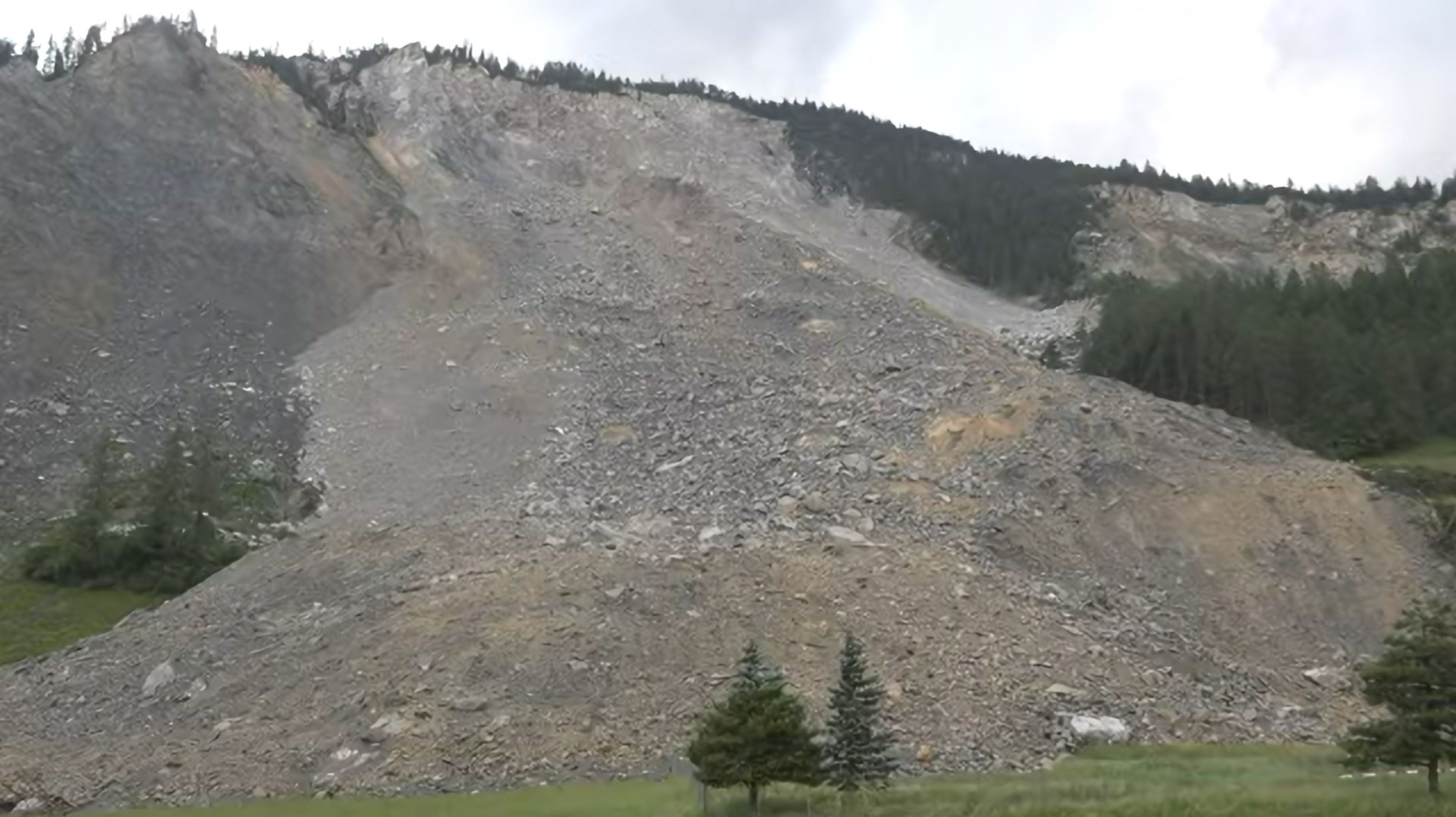
The aftermath of the major landslide at Brienz-Brinzauls on 15/16 June 2023. Screenshot from the Blick TV webcam.
.
The good news is that the the landslide appears to have missed the village itself. I captured a screenshot of the site late in the day yesterday, having tweeted that there was a large amount of rockfall activity occurring. This was the scene:-
The scene the day before the major landslide at Brienz-Brinzauls on 15/16 June 2023. Screenshot from the Blick TV webcam.
.
The slider below should allow you to compare the two images:-
.
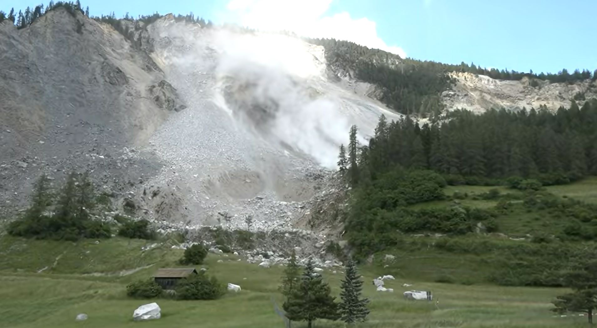
During this week the level of rockfall activity has been visibly increasing with time. On 13 June a part of the central part of the landslide, known as the island, collapsed in a series of events that were captured on the Blick TV webcam:-
The collapse of “The Island” at Brienz-Brinzauls on 13 June 2023. Screenshot from the Blick TV webcam.
.
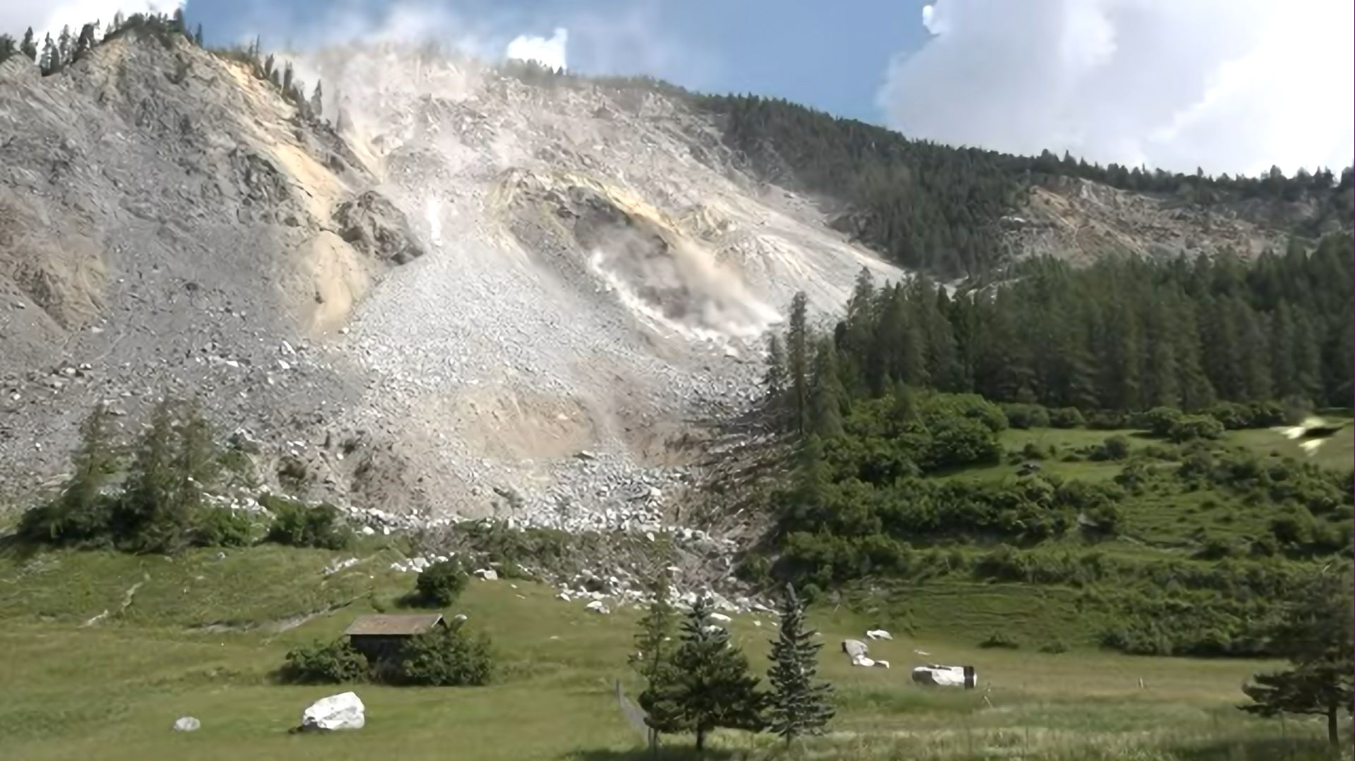
Meanwhile, Planet captured a very good, high resolution SkySat image of the site on 14 June 2023, after the collapse of The Island:
The site of the 15/16 June 2023 landslide, as captured by a high resolution Planet SkySat instrument. Image copyright Planet, used with permission.
.
We will await further information from the seismic analyses as to the precise timing of the landslide, the duration and the volume involved. It is undoubtedly a very large collapse. The radar data will also be fascinating as it could have continued to function in the dark. One thing that is certain is that there will be many relieved people this morning, even as analyses will now be needed as to the remaining risk to the village and surrounding area.
Initial news reports suggest that the village has been missed by the landslide, but that it was a very close shave:
“According to the announcement, no evidence was initially found that the rock masses had reached or damaged the village. At dawn it became clear that the island had just missed the village by a hair’s breadth, the statement said. A meter-high deposit formed directly in front of the school building. Whether there was any damage in the village can only be said after an aerial inspection in daylight.”
.
Reference
Planet Team (2023). Planet Application Program Interface: In Space for Life on Earth. San Francisco, CA. https://www.planet.com/
13 June 2023
First satellite imagery and seismic data from the 11 June 2023 Flüchthorn rock avalanche
First satellite imagery and seismic data from the 11 June 2023 Flüchthorn rock avalanche
Scientific data is now starting to emerge about the 11 June 2023 Flüchthorn rock avalanche in Austria. Planet has captured a satellite image of the site, although it is partially cloudy:-
PlanetScope image dated 12 June 2023 showing the 11 June 2023 Flüchthorn rock avalanche in Austria. Image copyright Planet, used with permission.
.
Better imagery will emerge in the coming days.
There is an interesting interview with the chief geologist of the Tyrol, Thoms Figl, online in German. He notes that:
“[He] sees disappearing permafrost as a possible trigger for the massive landslide – for which climate change is said to be responsible. That would not be a good sign for the future, because the ice is urgently needed as ‘glue’.”
The landslide is estimated to have a volume of at least 100,000 cubic metres, but this will be refined using both photogrammetry and inversion of the seismic data in due course. The seismic data has been published online by Micha Dietz – the density of the alpine seismic network means that this is an excellent dataset. The seismic data gives a precise timeframe for the event – it started at 15:05:30 local time and the run out of the landslide took two and a half minutes. Micha notes that there are distinct peaks in the seismic signal, the first of which probably relates to the impact of the rock mass with the valley floor.
Loyal reader Jan Beutel (@Jan Beutel) of the University of Innsbruck has also kindly highlighted that the landslide is recorded as an event in the Geosphere Austria catalogue.
Land Tirol has a page about the Flüchthorn rock avalanche, which includes a gallery of images of the source zone and track.
.
Reference and acknowledgement
Planet Team (2023). Planet Application Program Interface: In Space for Life on Earth. San Francisco, CA. https://www.planet.com/
12 June 2023
A large rock avalanche from Flüchthorn in the Austrian Alps
A large rock avalanche from Flüchthorn in the Austrian Alps
Loyal reader Jakob Steiner (@jakobfsteiner) kindly highlighted an interesting rock avalanche that occurred from the flanks of Flüchthorn in the Austrian Alps yesterday (11 June 2023). Flüchthorn, also known as Piz Fenga as it straddles the border with Switzerland, is a 3,399 m high peak in the Silvretta Alps in Europe. The location of the mountain is [46.891, 10.227].
The landslide was captured on a video that should be visible in the Tweet below:-
Ex-Permafrost.
Südliches Fluchthorn, Galtür. Nur ein paar Grad mehr, oder? pic.twitter.com/k63rHXo2ha
— Gebi Mair (@gebimair) June 12, 2023
.
The video, which was shot by Patrick Schöpf, captures both the collapse of the ridge and the resultant rock avalanche. Fortunately, it is thought that no-one was in the path of the landslide.
The Austrian newspaper Kronen Zeitung has a short article about the landslide (in German, but Google Translate is effective). It reports that the cross on the summit of the mountain has been removed – I guess Flüchthorn might be a little less tall now – and that the runout of the rock avalanche was about 2km. This image shows the track of the rock avalanche:-
The aftermath of the 11 June 2023 rock avalanche from Flüchthorn in the Austrian Alps. Image from Kronen Zeitung.
.
Blick has a helicopter video that shows the extent of the landslide, including the huge source area.
Interestingly, there is a video on Twitter that shows a flood lower on the mountain. I suspect that this will have come from the ice incorporated in the mass that collapsed from Flüchthorn, which would have been melted by the heat generated in the landslide.
It is interesting that this failure occurred in June. There is evidence from Alaska that large mountain collapses occur preferentially in the Spring and early Summer, and that they are associated with climate change. Clusters of events were loosely associated with El Nino periods. As we are just entering an El Nino event, and global temperatures are at unprecedented levels for this time of year, we are in for an interesting time.
9 June 2023
The causes of the 30 December 2020 Gjerdrum landslide in Norway
The causes of the 30 December 2020 Gjerdrum landslide in Norway
On 30 December 2020 the Gjerdrum landslide in Norway killed ten people. This large quick clay landslide occurred in the early hours of the morning following a wet autumn.
In the aftermath of the landslide public enquiry was established, which reported on 29 September 2021. The report is available online, in Norwegian. NK has a good summary, again in Norwegian, but Google Translate does a good job for those who are not well versed in that language.
The committee has determined that the trigger for the landslide was erosion of the banks of the stream that ran through the landslide area, called Tistilbekken. The heavy destruction in the area as a result of the landslide means that the exact nature of these small slips is not clear, but it is likely that they were associated with rainfall through a wet autumn. The committee noted that there is evidence from aerial imagery of high levels of erosion along the stream in the period from 2007 to 2015, which may have been associated with human activity, such as the installation of impervious surfaces and the removal of vegetation in the catchment.
Once an initial small failure occurred, the landslide underwent retrogression through a series of subsequent failures. The committee has presented this image showing the sequence of events, which is typical for a quick clay landslide:-
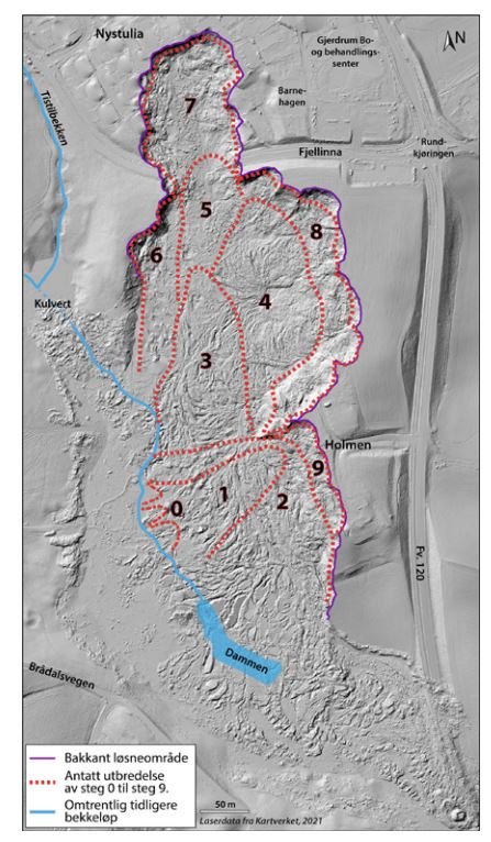
The postulated series of retrogressive failures in the 30 December 2020 Gjerdrum landslide in Norway. Image from the official investigation.
.
Event zero was the small slips on the banks of Tistilbekken. Removal of the toe allowed a small landslide to develop (event 1), and then the landslide retrogressed in a series of failures, eventually reaching the town.
Interestingly, the report states that:
“The committee believes that knowledge of erosion and the risk of landslides should have led to erosion protection measures in the lower part of Tistilbekken where the landslide started, which would have reduced the risk of a quick clay landslide.”
8 June 2023
Instability in ground works at the Cóndor Cliff dam in Argentina
Instability in ground works at the Cóndor Cliff dam in Argentina
On a day in which a large dam is very much in the international news, I came across an interesting article that has just been published in Open Access format in the journal Natural Hazards and Earth System Sciences (Tamburini-Beliveau et al. 2023) regarding instability in ground works at the Cóndor Cliff dam in Argentina. This is a large dam that is under construction, located at [-50.214, -70.781]. The dam will be a concrete face rockfill dam (CFRD), 75 metres high and 2,780 metres long according to Wikipedia, impounding a reservoir of 14 million cubic metres and generating an installed capacity of 1,140 MW.
Tamburini-Beliveau et al. (2023) describe a site with acute geological challenges, including weak and poorly compacted bedrock, predisposition to instability and the presence of faults. Although construction started in 2015, instability at the site meant that the design had to be changed, and some of the works had to be removed.
The paper uses PSI DInSAR to examine deformation of the southern abutment of the dam, which had reported slope instability during 2018 and 2019. They point out that the deformation is visible on publicly available imagery. This is a Google Earth image from May 2020 of the site:-
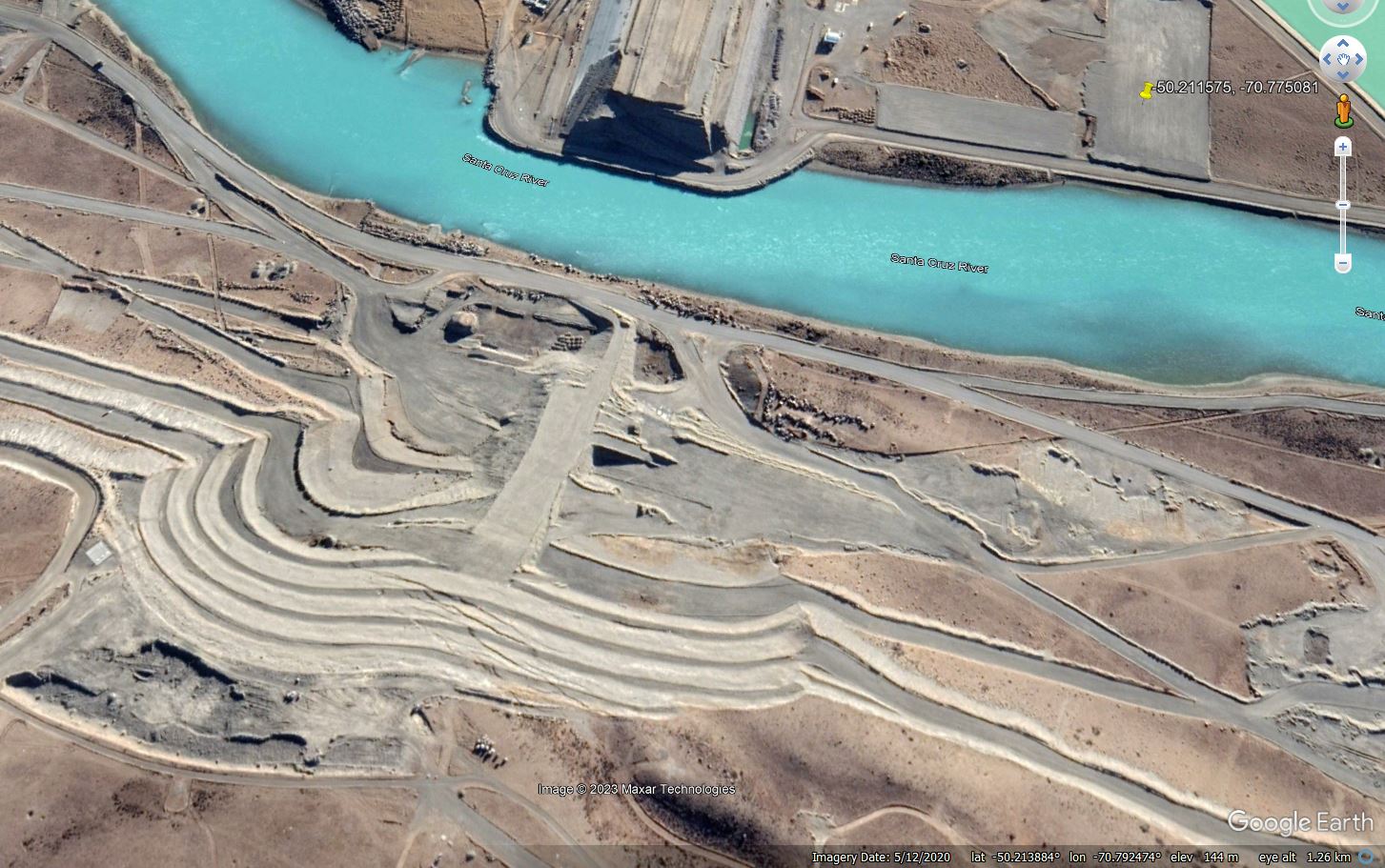
Google Earth image of the groundworks at the Cóndor Cliff Dam in Argentina in May 2020.
.
In the ground works in the lower centre of the image a series of large, sub-parallel cracks can be clearly seen. These extend over a distance of about 250 m along the length of the cracks and 50 metres in width. There is a further image, probably from May 2022 (an exact date is not given in Google Earth), that also shows these cracks:-
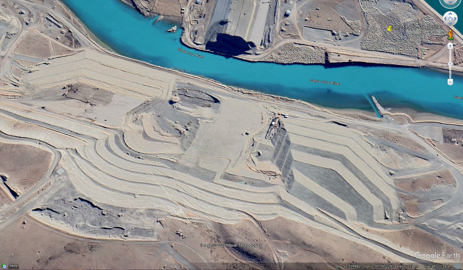
Google Earth image of the groundworks at the Cóndor Cliff Dam in Argentina, possibly in May 2022.
.
The DInSAR work of Tamburini-Beliveau et al. (2023) indicates that instability at the Cóndor Cliff Dam started in early 2019 and was continuing in April 2021, at the end of the data series. Deformation was also recorded on the slopes around the northern abutment. Peak deformation rates of 32 mm per year were recorded.
There is little information about the ways in which these engineering challenges are being addressed that I can find. Does anyone have any information?
.
Reference
Tamburini-Beliveau, G., Balbarani, S., and Monserrat, O. 2023 Brief communication: Landslide activity on the Argentinian Santa Cruz River mega dam works confirmed by PSI DInSAR, Natural Hazards and Earth System Sciences, 23, 1987–1999, https://doi.org/10.5194/nhess-23-1987-2023, 2023.
7 June 2023
Landslides from the 5 September 2022 Luding Earthquake in China
Landslides from the 5 September 2022 Luding Earthquake in China
The 5 September 2022 Mw=6.7 Luding Earthquake was a shallow event that struck a mountainous area of Sichuan Province. The earthquake killed 93 people and left a further 24 missing, with 424 people being injured. The majority of the death toll was associated with building collapses and landslides, although the breakdown between the two causes is unclear. It is likely that many of those whose bodies were not recovered died in landslides. I posted some images of the landslides triggered by this event shortly after the earthquake.
The town closest to the epicentre was Moxi [29.59, 102.08] in Luding County, which suffered many landslides. A new paper in the journal Landslides (Liu et al. 2023) documents these failures, recording 192 landslides in the vicinity of the town. Most of the failures were small, but they were damaging.
I thought it would be interesting to compare satellite imagery of Moxi town, and its surrounding area, before and after the Luding Earthquake. This is an area that is heavily affected by cloud, especially in the summer months, so I have chosen two images about a year apart. This is a Planet satellite image from 21 April 2022:
Planet satellite image of Moxi in Sichuan, China, collected before the Luding Earthquake. Image copyright Planet Labs, used with permission, dated 21 April 2022.
.
Whilst this is the same site, collected on
Planet satellite image of Moxi in Sichuan, China, collected after the Luding Earthquake. Image copyright Planet Labs, used with permission, dated 4 May 2023.
.
And for reference, as it is easier to compare, here is a slider to compare the two images:
.
The large number of landslides that have developed between the capture of the two images is interesting. Of course, these were not necessarily triggered by the Luding Earthquake given the time gap (they could have been triggered by heavy rainfall, for example), but it is highly likely that the vast majority were coseismic. There is a large number of shallow disrupted slides in the west of the image, on the steeper slopes into the drainage system (not the optical illusion that makes the valley look like a ridge), and also some landslides on the slopes around the town.
It will be very interesting to see how these landslides develop in the Summer 2023 rainy season. Debris flows look likely in heavy rainfall events.
.
References and acknowledgement
Planet Team (2023). Planet Application Program Interface: In Space for Life on Earth. San Francisco, CA. https://www.planet.com/
Liu, X., Su, P., Li, Y. et al. 2023. Spatial distribution of landslide shape induced by Luding Ms6.8 earthquake, Sichuan, China: case study of the Moxi Town. Landslides (2023). https://doi.org/10.1007/s10346-023-02070-2
6 June 2023
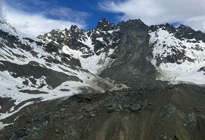
The 4 June 2023 landslide at Yongsheng Township in Sichuan Province, China
The 4 June 2023 landslide at Yongsheng Township in Sichuan Province, China
On 4 June 2023 a fatal landslide occurred at Yongsheng Township in Jinkouhe District, part of the area administered by Leshan City in Sichuan Province in China. The landslide struck the dormitory of a phosphorite mine, killing 19 people. Rescue and recovery operations have concluded.
Xinhua News has released this image of the site:-
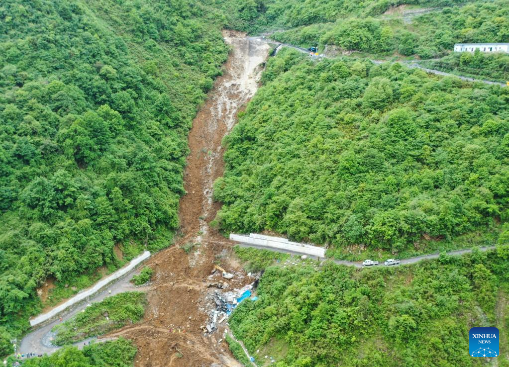
The 4 June 2023 landslide at Yongsheng Township in Sichuan Province, China. Image via Xinhua News.
.
Yongsheng appears to be located at [29.369, 103.065], although this is unconfirmed and I have not tied down the precise location of the landslide itself.
The landslide itself is interesting. It appears to be to be a failure in a gentle gully, probably initiated at the crown of the landslide scar but then entraining a large volume of material downslope. The location of a destroyed structure is visible, alongside a backhoe.
Note that the crown is located on a hairpin bend on the road, with a small cut visible too. It is hard to believe that this landslide is not associated with the road; a working hypothesis might be that a fill slope was created on the downslope side of the hairpin bend, possibly with material from the road cut, to widen the road at this point, allowing vehicles to swing around the corner. This fill material might then have failed, loading the slope and progressively driving a larger failure. That fill is present is potentially supported by the fine-grained, grey material visible in the upper part of the landslide scar.
Yahoo News also has an image of the site, taken from another angle:
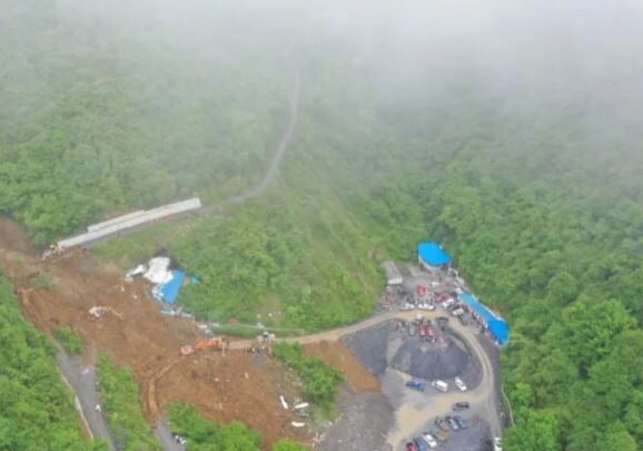
The lower part of the 4 June 2023 landslide at Yongsheng Township in Sichuan Province, China. Image via CCTV / Yahoo News.
.
The grey area on the right of the image is reported to be the platform of the mine being developed by Jinkaiyuan Mining Company. Heavy rainfall was reported at the time of the landslide, which injured seven people in addition to the 19 fatalities. This is the early part of the rainy season in China, when most landslides occur.
 Dave Petley is the Vice-Chancellor of the University of Hull in the United Kingdom. His blog provides commentary and analysis of landslide events occurring worldwide, including the landslides themselves, latest research, and conferences and meetings.
Recent Comments