19 June 2023
An update on the 11 June 2023 Flüchthorn rock avalanche
Posted by Dave Petley
An update on the 11 June 2023 Flüchthorn rock avalanche
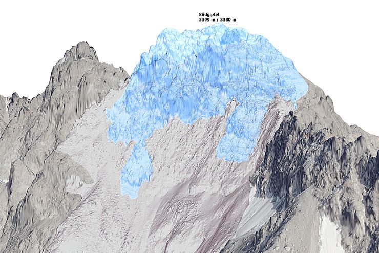
Land Tirol has published (in German) some information about the 11 June 2023 Flüchthorn rock avalanche in Austria. Most interestingly, they have collected aerial laser scanning of the mountain, which has allowed an estimate to be made of the volume of the landslide, which is reckoned to be 1 million cubic metres. There ae two particularly interesting graphics. First, one highlighting the volume of rock that has been lost:-

A reconstruction using laser scan data of the volume lost in the 11 June 2023 Flüchthorn rock avalanche in Austria. Image copyright State of Tyrol, via Land Tirol.
.
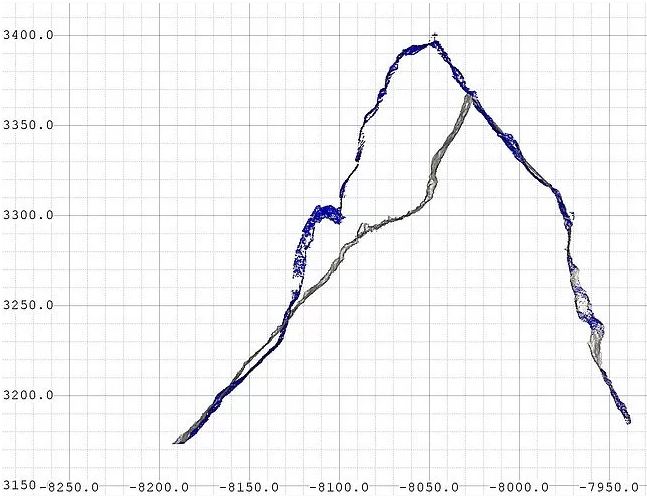
Second is an initial cross-section, also using the laser scan data, showing the change in topography:-

A cross-section using laser scan data showing the volume lost in the 11 June 2023 Flüchthorn rock avalanche in Austria. Image copyright State of Tyrol, via Land Tirol.
.
The southern peak of the mountain has reduced in elevation by 19 m, from 3,399 m to 3,380 m, and the mountain top has been displaced laterally by about 30 m. This event is unusual, but not unique, in cleaving through the summit in this way.
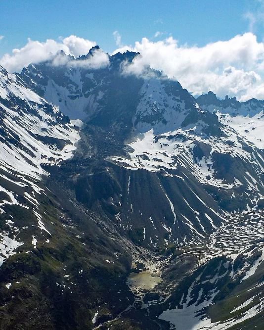
The best image that I have seen of the whole of the landslide has been released by Land Tirol:-

The entire track of the 11 June 2023 Flüchthorn rock avalanche in Austria. Image copyright State of Tyrol, via Land Tirol.
.
Note the very steep initial fall of the landslide, then the runout over a terrace, before a steep descent into the lake. There will undoubtedly be modelling undertaken of this event, which will be published in due course. It is very fortunate that there was no-one in the path of this major rock avalanche.
Finally, Micha Dietz has published some further seismic analyses of the event, which is worth reading. It is interesting to see how different stations captured different elements of the seismic signal generated by this landslide.


 Dave Petley is the Vice-Chancellor of the University of Hull in the United Kingdom. His blog provides commentary and analysis of landslide events occurring worldwide, including the landslides themselves, latest research, and conferences and meetings.
A quick Youtube tour of Flüchthorn on 2018 DEM, before the debris avalanche of June 11: https://youtu.be/KXWMI0qcLc0
Another Youtube movie of the avalanche footprint draped on slope map and DEM:
https://youtu.be/kDPg2_Rkbro .
1. Export Sentinel-2, band 8 as png file, with pnw world file from GIS.
2. In graphic image processing program, select the pixels of the landslide footprint. Invert the selection, delete all but the footprint pixels to transparent. Replace the footprint to the original filename to maintain the world file location.
3. Import the footprint to the GIS as a layer over the base layer, draped on the DEM for 3D perspective.
It appears that the debris avalanche diagonaled across the valley, caromed off of the north slope of the valley and launched off of the valley floor ramp into the stream canyon? Many other landslide deposits are seen in the slope map.