21 June 2023
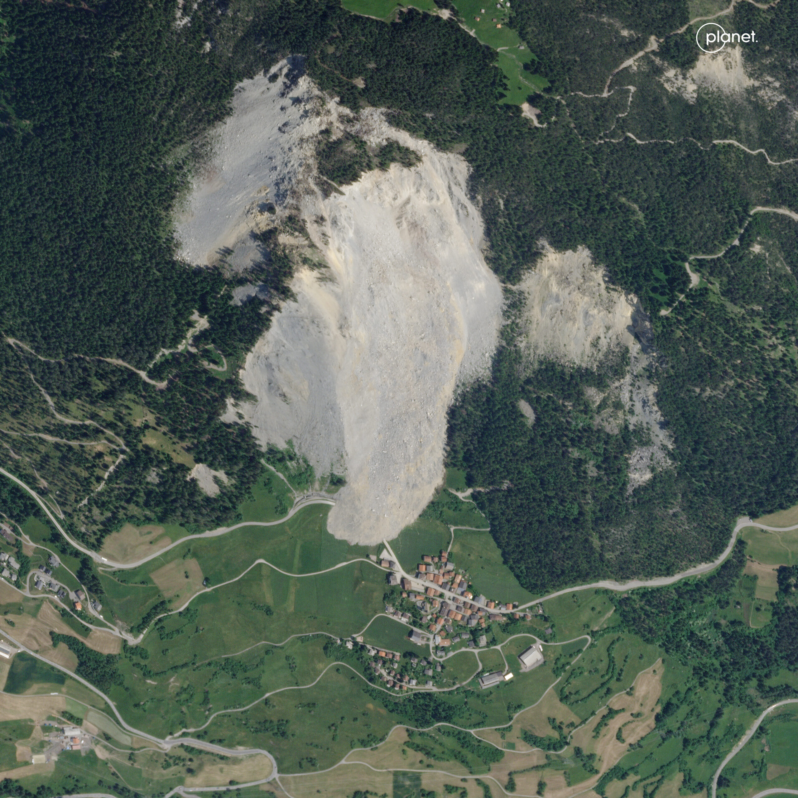
Post-failure Planet image of the Brienz-Brinzauls landslide
Posted by Dave Petley
Post-failure Planet image of the Brienz-Brinzauls landslide
The major failure at Brienz-Brinzauls on 15 June 2023 has attracted considerable attention. The landslide occurred at 23:38 local time on 15 June. Initial estimates are that about 1.2 million cubic metres of rock detached, with a shear surface that is about 50 m deep. The peak velocity is estimated to have been 80 km/h.
Planet has captured a high resolution satellite image of the aftermath of the landslide:-

The aftermath of the 15/16 June 2023 landslide, as captured by a high resolution Planet SkySat instrument. Image copyright Planet, used with permission.
.
As the image demonstrates, the lower part of the main path of the landslide did not flow towards the village, and the mass stopped short of the houses. Thus, Brienz-Brinzauls is essentially undamaged.
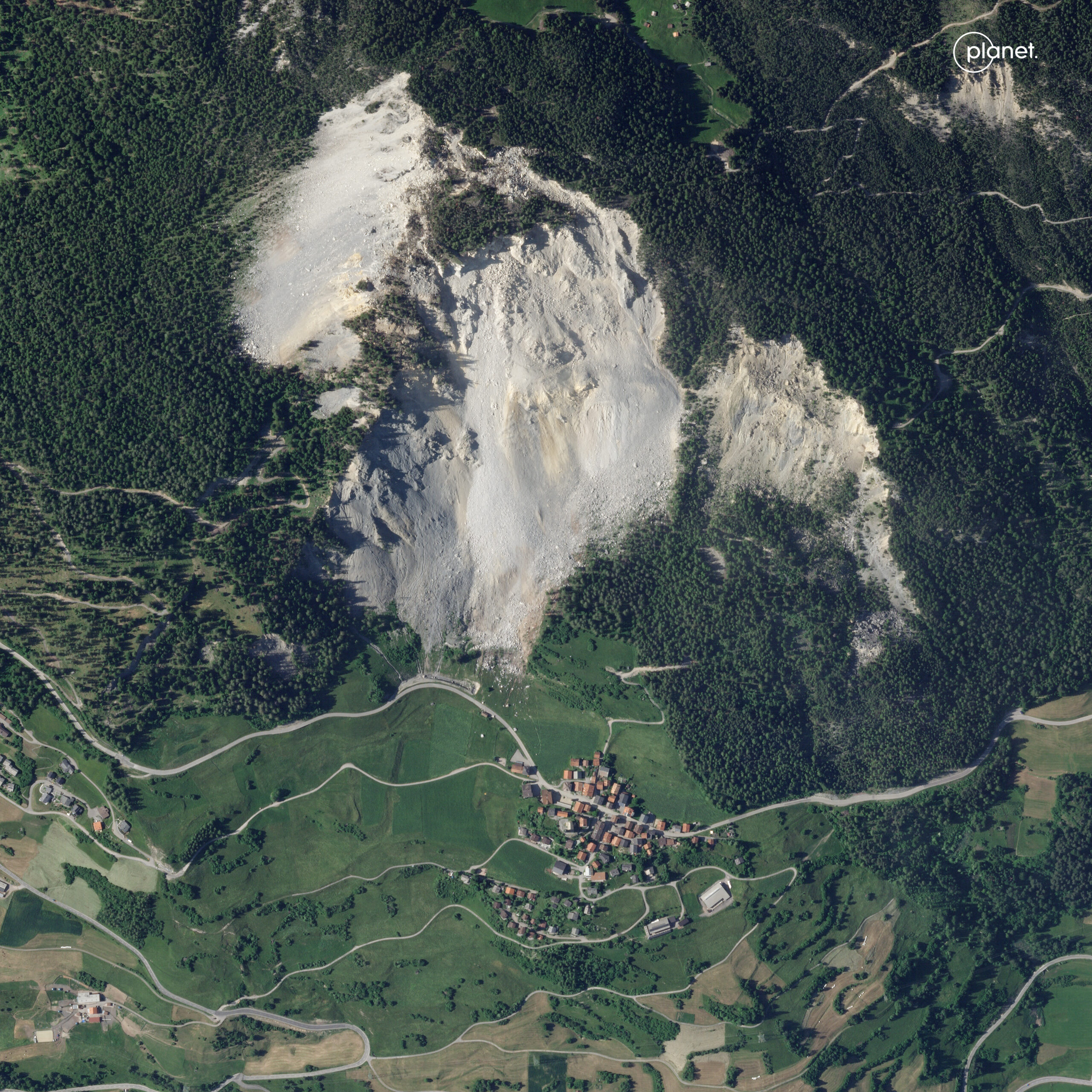
The slider below should allow you to compare the before and after Planet Skysat images:-


As the image above shows, the main detachment is from the central part of the slope – this is the area known as The Island. There is limited loss of mass at the crown of the landslide. Runout distance appears to be quite modest for a landslide on this scale, probably because of the topography.
It is well documented that Brienz-Brinzauls is located on an area of the slope that has been actively deforming, albeit at rates that are much more modest than had been the case upslope. A fascinating element of the dynamics of the landslide will be to see how this lower slope now responds to the main failure. This is quite difficult to predict without a detailed understanding of the dynamics of the landslide complex. Work will also be needed to ensure that the landslide debris itself is stable, especially in the event of heavy rainfall. Hopefully, the village will be safe to reoccupy.
Overall, this is a good outcome for Brienz-Brinzauls.
.
Reference and acknowledgement
Many thanks to my friends at Planet for another stunning image.
Planet Team (2023). Planet Application Program Interface: In Space for Life on Earth. San Francisco, CA. https://www.planet.com/


 Dave Petley is the Vice-Chancellor of the University of Hull in the United Kingdom. His blog provides commentary and analysis of landslide events occurring worldwide, including the landslides themselves, latest research, and conferences and meetings.
Here is a Youtube video of the Brienz-Brinzauls landslide in 10m/px Sentinel-2 Satellite imagery, 26 April (before) and 25 June (after), 2023: https://youtu.be/VlyXYrBiaIo
Medium resolution satellitee shows rapid snow melt in May: https://worldview.earthdata.nasa.gov/?v=8.120834765625006,45.6433837890625,11.069565234375006,47.7066162109375&l=Reference_Labels_15m,Reference_Features_15m(hidden),Coastlines_15m,MODIS_Aqua_Land_Surface_Temp_Day(hidden),MODIS_Aqua_Land_Surface_Temp_Night(hidden),OrbitTracks_Suomi_NPP_Ascending(hidden),OrbitTracks_Terra_Descending(hidden),OrbitTracks_Aqua_Ascending(hidden),MODIS_Terra_Thermal_Anomalies_All(hidden),VIIRS_SNPP_Thermal_Anomalies_375m_Night(hidden),VIIRS_SNPP_Thermal_Anomalies_375m_Day(hidden),MODIS_Combined_Thermal_Anomalies_All(hidden),MODIS_Aqua_Thermal_Anomalies_All,MODIS_Aqua_CorrectedReflectance_Bands721,VIIRS_SNPP_CorrectedReflectance_BandsM11-I2-I1,MODIS_Terra_CorrectedReflectance_Bands721,VIIRS_SNPP_CorrectedReflectance_TrueColor(hidden),MODIS_Aqua_CorrectedReflectance_TrueColor(hidden),MODIS_Terra_CorrectedReflectance_TrueColor&lg=false&s=9.5952,46.675&t=2023-05-03-T06%3A00%3A00Z