9 June 2023
The causes of the 30 December 2020 Gjerdrum landslide in Norway
Posted by Dave Petley
The causes of the 30 December 2020 Gjerdrum landslide in Norway
On 30 December 2020 the Gjerdrum landslide in Norway killed ten people. This large quick clay landslide occurred in the early hours of the morning following a wet autumn.
In the aftermath of the landslide public enquiry was established, which reported on 29 September 2021. The report is available online, in Norwegian. NK has a good summary, again in Norwegian, but Google Translate does a good job for those who are not well versed in that language.
The committee has determined that the trigger for the landslide was erosion of the banks of the stream that ran through the landslide area, called Tistilbekken. The heavy destruction in the area as a result of the landslide means that the exact nature of these small slips is not clear, but it is likely that they were associated with rainfall through a wet autumn. The committee noted that there is evidence from aerial imagery of high levels of erosion along the stream in the period from 2007 to 2015, which may have been associated with human activity, such as the installation of impervious surfaces and the removal of vegetation in the catchment.
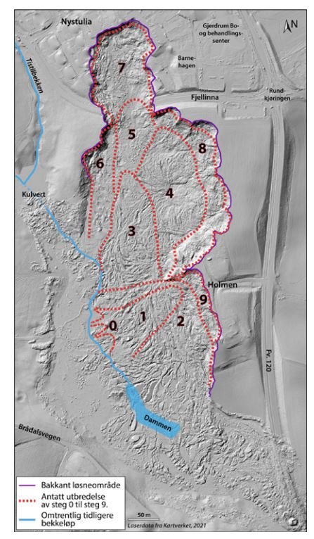
Once an initial small failure occurred, the landslide underwent retrogression through a series of subsequent failures. The committee has presented this image showing the sequence of events, which is typical for a quick clay landslide:-

The postulated series of retrogressive failures in the 30 December 2020 Gjerdrum landslide in Norway. Image from the official investigation.
.
Event zero was the small slips on the banks of Tistilbekken. Removal of the toe allowed a small landslide to develop (event 1), and then the landslide retrogressed in a series of failures, eventually reaching the town.
Interestingly, the report states that:
“The committee believes that knowledge of erosion and the risk of landslides should have led to erosion protection measures in the lower part of Tistilbekken where the landslide started, which would have reduced the risk of a quick clay landslide.”


 Dave Petley is the Vice-Chancellor of the University of Hull in the United Kingdom. His blog provides commentary and analysis of landslide events occurring worldwide, including the landslides themselves, latest research, and conferences and meetings.
Do you mean “2007 to 2015”?
Is there a risk of more landslides in the area?
Protection measures seem to include excavating the clay down to bedrock or putting in lots of piles; both sets of work are visible in google maps.
Here is a good, comprehensive (English) review of quick clay geotechnology: Rankka, Karin; Andersson-Sköld, Yvonne; Hultén, Carina; Larsson, Rolf; Leroux, Virginie; Dahlin, Torleif, 2004. Quick clay in Sweden. Report No. 65. Swedish Geotechnical Institute.
https://www.swedgeo.se/globalassets/publikationer/rapporter/pdf/sgi-r65.pdf
or from an internet archive
https://web.archive.org/web/20050404064431/http://www.swedgeo.se/publikationer/Rapporter/pdf/SGI-R65.pdf
My take, buried glacial sediment encased in a saltwater flocculated shell.
I was just reading this report this week. Also, an interesting point from the committee, was that there were several warnings that this could happen, which if acted upon, could have prevented the disaster. One was a letter from a landowner to the municipality, which included annotated photos. One [pg. 148] shows an outlet pipe which has collapsed in a slip at the base of the slope. Translated, one of the comments says: “This is the area that gives us as landowners the greatest concern. A large area to the right of the stream has all slipped out. This is where the terrain is steepest and a major slip here will dam up and, in the worst case, trigger a catastrophe.”
There are statistically around 1.5 large quick clay landslides per year in Norway. The challenge moving forward is designing an early warning system to ensure such warnings are acted upon, along with technological automatic monitoring of stream erosion in risk zones, in order to prevent such disasters from happening again. This case was due to erosion, with development increasing erosion rates. However, many quick clay landslides are caused by human activity, usually improper construction. Addressing the human risk factors in a quick clay EWS will perhaps be more of a challenge than designing a sophisticated erosion monitoring system.
Here, the report says that this landslide could have been prevented by protecting the toe of the slope from further erosion in the creek downstream from this neighbourhood. Erosion prevention measures could include placing concrete blocks along the side of the stream being eroded. This slide started with a small slump on the side of the stream, which reduced the slope stability over a much larger area, and then back-propagated in sections as shown above, about 2 km (over about 2 minutes).