30 December 2020
Gjerdrum: a quick clay landslide disaster in Norway this morning
Posted by Dave Petley
Gjerdrum: a quick clay landslide disaster in Norway this morning
The latest update on the Gjerdrum landslide is in a new post
Overnight, a large quick clay landslide has struck the village of Ask in the municipality of Gjerdurm in Norway. News reports from this landslide are a little confused as I write this – unsurprisingly – but it is clear that the slide has swept away a number of houses. Reports suggest that up to nine people might have been injured. About 700 people have been evacuated so far. It is reported that 14 buildings have been lost to date. Update: as the afternoon ends in Norway reports indicate that 12 people are not accounted for, some of whom are children. Unfortunately, the rescue services have not been able to enter the area affected by the landslide. This is the correct decision – this slope is likely to still be highly unstable. A further three houses have been lost during the day.
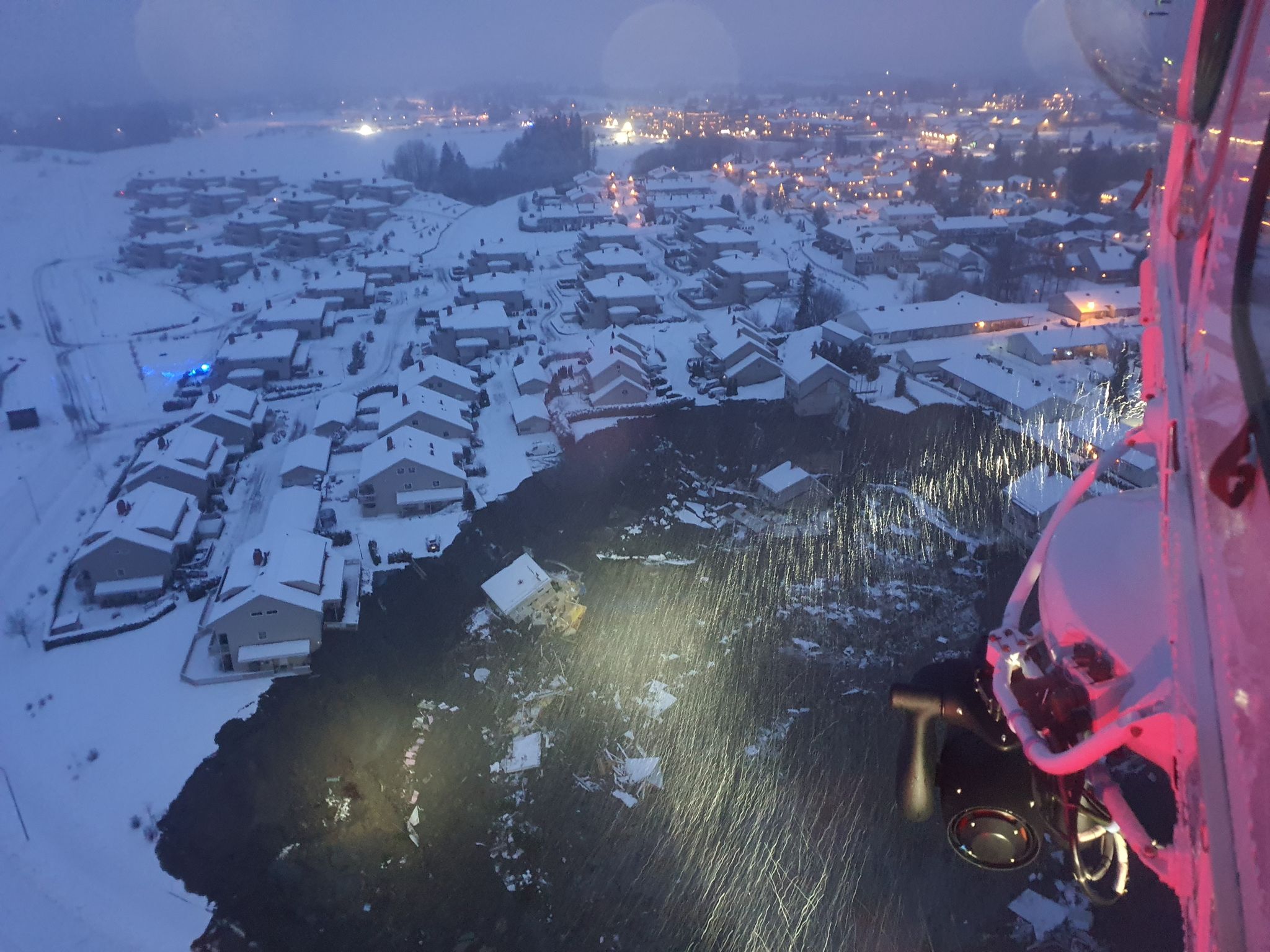
Aftenposten has this image of the upper reaches of the quick clay landslide at Gjerdrum:-

The quick clay landslide at Gjerdrum in Norway. Image from Aftenposten, collected by Foto: 330-skvadronen / Hovedredningssentralen.
.
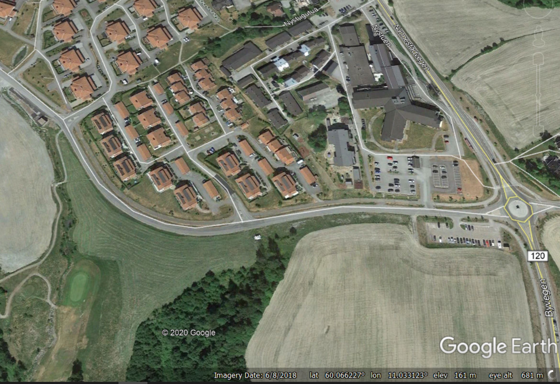
The Norwegian Police have described this event as a disaster. The site of the landslide appears to be the area shown in the Google Earth image below – the location is 60.065, 11.036:-

Google Earth image showing the site of the 30 December 2020 Gjerdrum landslide in Norway.
.
Reports indicate that the alert was sounded at about 4 am local time. The landslide remains unstable, and some retrogression of the head scarp is still occurring. It is not clear how far downslope the landslide extends, but the images suggest that this is a very substantial failure.
Gjerdrum has suffered quick clay (sensitive clay) landslides before. For example, Google Books has a case study of a significant event in 2012.
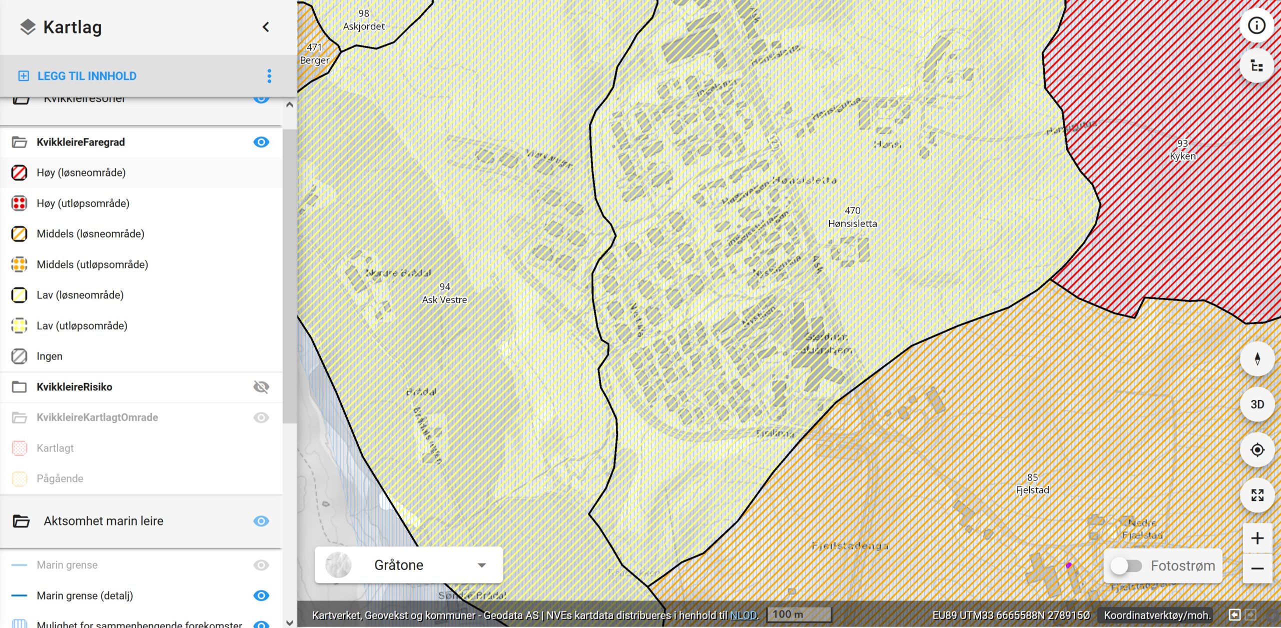
This is the NVE quick clay hazard map for the area:

NVE Quick Clay hazard map showing the site of the 30 December 2020 Gjerdrum landslide in Norway.
.
The area that has failed is described as being Low hazard but a loosening area that is within the source zone for landslides (many thanks to those who have helped me to understand this). However, it is immediately adjacent to an area described as medium hazard.
VG TV has a video of a house collapsing into the landslide bowl. It demonstrates that this is a very large failure (unfortunately I cannot embed this video):-
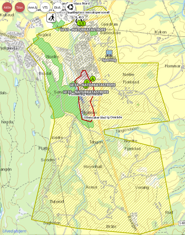
https://www.vgtv.no/video/210593/vgs-reporter-om-hus-i-jordskredsomraade-staar-delvis-i-loese-luftaThe Norwegian Police have now released a map showing the area affected by the Gjerdrum landslide (in red). The large area with green hatching is the zone that has been evacuated today.
The latest update on the Gjendrum landslide is in a new post

The area afftected by the Gjerdrum landslide – map generated by the Norwegian Police.


 Dave Petley is the Vice-Chancellor of the University of Hull in the United Kingdom. His blog provides commentary and analysis of landslide events occurring worldwide, including the landslides themselves, latest research, and conferences and meetings.
It looks more like a sinkhole from the photos
[It is most definitely not a sinkhole. D.].
OpenStreetmap has a sketch of the area directly destroyed by the quick clay landslide. https://www.openstreetmap.org/way/890072333
Official, but definitive map (red area): https://www.politiet.no/politiet-informerer/jordskred-i-gjerdrum/jordskred-pa-ask-i-gjerdrum/kart-over-evakueringssoner/
It looks like a quick clay landslide from the photos (more – many more – in Norwegian newspapers & TV).
In fact, it IS a quick clay landslide.
BTW – 15 persons missing now 2020-12-30 17:20
I don’t actually know Norwegian, but I do know some Swedish, which isn’t too far… My interpretation of “løsneområde” is “source area”, and “utløpsområde” is something like “runout area”.
Thank you for your analysis!
Although it will be a long way to find out push factors for this case:
1) Could the golf course in “Tistilbekken” have caused a change in hydrology?
2) on the opposite side of the Tistilbasin is a hamlet named “Brådal”.(https://norgeskart.no/#!?project=norgeskart&sok=S%C3%B8ndre%20Br%C3%A5dal&layers=1002&zoom=14&lat=6664956.34&lon=279034.46&markerLat=6664956.3401732715&markerLon=279034.4560470433&panel=searchOptionsPanel)
brå means abrupt – so the whole name could mean “Abrupt Valley” ….nomen est omen
A typical landslide usually involves a mountain, why the fuck are we introducing different methodologies with a made up series of words..this is devastating for the owners of these home and the families that live their. I pray for the families and hopefully the world really starts paying attention to these problems…our world is growing and we should as well, knowledge is key
[No it doesn’t, we aren’t (the concept of a quick clay landslide has been around for many years)…yes it is devastating, and I agree that more focus is needed. You are right that knowledge is key, but so is policy. D.]
You can visualise the Lidar DEM using our InSAR map service here: https://insar.ngu.no/#llh=11.03539494,60.0532247,1372.5947042&look=-0.19640127,-0.32788251,-0.9240777&right=0.97719458,0.01214097,-0.21199848&up=-0.0807298,0.94464049,-0.31802051&layers=bluemarble,Base%20Layers_Base%20Layers-las_dtm_skyggerelieff_somlos:skyggerelieff_40grader
It seems the area that is affected is a hillside cut by several ravines.
If you want to see orthophoto, change the map base layer to “Norge i Bilder”
As expected, there is nothing of interest to be found in the InSAR data, as no long term precursor movement would have occurred.
Here’s a video of the damage 🙁
https://www.youtube.com/watch?v=AZkusTcFq9Q
According to google maps one of those buildings was a kindergarten and one near/possibly in the hole is a nursing home. Street view gives abetter idea of how steep the hill there is/was. How horribly tragic.
Although it might be to early to talk about push factors:
1) Damage or mistakes in drainaige of the new built roads (Fjellina) could have caused the slide, btw. the landslide is already mapped on OSM!
2)or changes in hydrology due to Brådal golf club. Btw. “brå” means “abrupt”. as the name is historic, it might refer to the origin of the valley “Tistilbekken”
3) on Statens Cartvesen you kann see the very rugged topography downhill, especiallywest of the hamlet “Holmen”, where also on house fell down the rupture
Sad consequences for affected people, hope recovery for residents and ground stabilisation is quick as the clay. Any engineering geologist / geotech guy worth his saltmine knows about clays deposited under very low energy cold conditions in the last Ice Age. In this world the amount of ignorance and inaction with landslide risk is amazing – wonder if gradual lowering of shear strength or sudden mechanism triggered this one.
There seem to be conflicting reports of the hazard rating in this area depending on who was asked and when: https://www.nrk.no/norge/skredomradet-i-gjerdrum-er-i-risikoklasse-5-1.15307473
NGU’s servers seems to be overloaded at present, so I can’t check this.
“Brå” can mean “abrupt”, “sudden” or “steep”, but it may also refer to a place where the snow melts first in the spring. All of these are equally plausible for a south-facing slope.
The rescue operations are difficult for these reasons:
1) the landslide masses are still moving and highly unstables (as always in quick clay slides) so rescue teams can only work from air with helicopters;
2) limited day light, at this time of the year the sun rise around 8:30-9:00 and 16:00 is already dark;
3) cold temperatures and snowing all day yesterday (even darker). Today there is a more clear sky, but colder than yesterday.
Colder temperatures are expected in the next days complicating more the rescue operations
Hello Graziella from the USGS (now retired) in Colorado. Thinking of you and hoping for the best with the terrible situation. Sue Cannon
Here is a google earth view of the area with a 3:1 vertical to horizontal exaggeration, there seems to be a 70-100 mts difference bettween the high parts of the slope failure and the lower parts on the west ravine. It is not difficult to see the countours of possible previous slope failures, in particular just south of the town in the area that just failed. https://www.flickr.com/gp/roberto_de_ayllon_y_cardenas/mGR4nn
Salt content in the clay acts as a stabilizer. When water content gets high and the salt is washed out the clay looses its structure and liquifies.
Here is a video covering the whole area: https://www.aftenposten.no/norge/i/BlGynE/dette-er-status-morgenen-1-nyttaarsdag-gir-fortsatt-ikke-opp-haapet-om
Very illustrative Roberto!
There has not been a quick clay disaster like this since 1893 in Norway. The Verdal slide.
Verdal disaster 1893:
55 million m3 landslide.
116 people died, more than 80 farms where destroyed.
An area of 3 square kilometers glided out due to the quick clay. Another 9 square kilometer was hid and flooded with clay and water (river blocked)
Picture collection with Norwegian tales: https://www.youtube.com/watch?v=xrKzo2Iu7jc
In ref to note 7 the data set ..truncated in 2019 for whatever reason …….Sentinel1 Asc and DESC — displays a rate for 120 points in target area of -1 mm a year, with a lot of phase ambiguity … likely more p/year —
I have set a screen shot to D.Petley.
Where is the 2019-2020 data?
I made a youtube video where quick clay slides are explained
https://www.youtube.com/watch?v=LPH-HuszoQ4
I hope you find this useful