
29 March 2017
Nepal rural roads: the hazards of construction without design
Nepal rural roads: landslide problems along a major highway
Nepal rural roads: the hazards of construction without design
One of the major themes that I return to regularly is the problem of Nepal rural roads, and the landslides associated with them. Regular readers will know that I have an intense interest in landslides in Nepal, one of the true global hotspots for landslide problems. My interest in Nepal started way back in 2000 when I was involved in a research project that sought to find better ways to select the routes for rural roads to reduce landslide hazards. That project was led by Dr Gareth Hearn, then of Scott Wilson but now working for Hearn Geoserve, who is in many ways the guru of rural road design in high mountain areas. Gareth is also the best geomorphological mapper I have ever met, as well as a highly talented engineering geologist. He has written numerous publications about the assessment of terrain in steep mountain areas, and is the author of various guidelines about rural road building.
In a paper just published in the Quarterly Journal of Engineering Geology with N.M. Shakya from the Department of Roads in Nepal (Hearn and Shakya 2017), Gareth has examined problems of rural road construction in Nepal and India once more. The paper notes that there are numerous guidelines for proper road construction, and that the underlying techniques are well established. In the paper, they highlight a World Bank report from 2013 that notes that:
…it was stated that over half of the local road network is untraffickable owing to non-engineered road construction, with roads becoming impassable within 1 – 2 years after completion. If this estimate is true, there may be of the order of 30,000 km of roads constructed in the country that have little hope of sustainability without significant remedial investment and that are having, by all accounts, severe impacts on slopes and drainage systems.
Hearn and Shakya (2017) suggests a number of key issues that need to be addressed:
- Proper route selection is needed. They note that: “there is rarely such a thing as the perfect alignment because compromises often have to be made between the desire to avoid crossing difficult and geohazard-prone terrain and environmentally sensitive areas, and the need to minimize route length and construction cost. It is usually necessary to identify those areas that pose the greatest difficulty and highest risk, and avoid them where possible.”
- Construction must be appropriate, using design that is carefully considered around management of water, support of cut slopes and the emplacement of fill.
- Careful consideration of the hazards posed to road users and people living along the road corridor.
The frustration of course is that none of this is new. As Hearn and Shakya (2017) point out:
Sustainable engineering for the future development of infrastructure in the Himalayas is entirely achievable as long as a carefully planned, managed and executed, inclusive approach is applied. This approach must make full use of the experience and professional knowledge embodied in the available guidelines and specifications, take full cognisance of the geological and geomorphological fragility and dynamism of the region, and learn from the successes and failures of the past.
This paper is both wise and perceptive. It really is time to start constructing Nepal Rural Roads properly.
Reference
and Engineering challenges for sustainable road access in the Himalayas Quarterly Journal of Engineering Geology and Hydrogeology, doi:10.1144/qjegh2016-109
28 March 2017
2017 International Summer School on Rockslides and Related Phenomena in the Kokomeren River Valley (Kyrgyzstan)
2017 International Summer School on Rockslides and Related Phenomena in the Kokomeren River Valley (Kyrgyzstan)
In summer 2017 Dr Alexander Strom and Professor Kanatbek Abdrakhmatov will once again organise the International Summer School on Rockslides and Related Phenomena in the Kokomeren River Valley of Kyrgyzstan. This course has been running since 2006. This area of Kyrgyzstan is notable for the unusual concentration of large landslides ranging in size from a few million to over a billion cubic metres. Thanks to the arid climate and comparatively low level of human activity, the features are exceptionally well preserved in the landscape. The map, below, from the flyer advertising the course, gives an indication of the density of these landslides in this area:
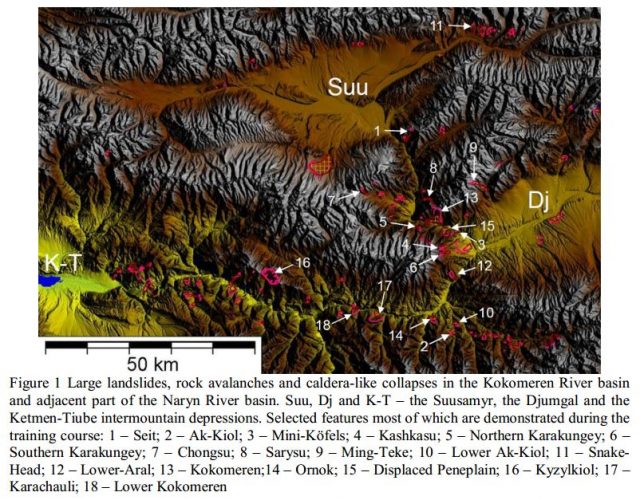
Mapped landslide features in the area of the 2017 Summer School, from the flyer for the course
.
The guidebook for the 2016 summer school is available online, and is a fantastic document in its own right. This image shows the type of features that are visited on the trip:
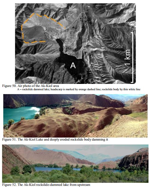
Images from the field guide from the 2016 summer school
.
The 2017 training course will be held between 5th and 20th August. The participation fee is just 500 Euros, which includes all costs at the site: camping, food, local transportation and the detailed full-colour guidebook, which seems like an absolute bargain to me.
Further details are available on the ICL website. I would love to participate in this course – I so wish I had the time! I have heard nothing but praise from those who have participated in the past. The combination of the landscape, the active tectonic setting, the landslides themselves, the expert guides and the opportunity to build a network with a range of landslide specialists is important.
The ICL is also highlighting a summer school to run from 21st May to 10th June 2017 on Natural Disasters, to be run in Ljubljana, Slovenia.
27 March 2017
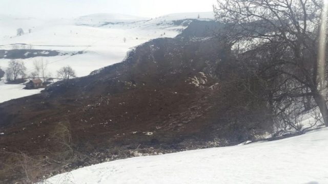
A very large fatal landslide at Nichke-Sai in Uzgen, Kyrgyzstan yesterday
A very large fatal landslide at Nichke-Sai in Uzgen, Kyrgyzstan yesterday
The village of Nichke-Sai in Uzgen in the Osh region of Kyrgyzstan was struck by a large landslide yesterday. Reports are somewhat sketchy – the only one in English I can find is on AKIpress – but the indications are that a family of six people were killed. A local news site, Turmush, has a report in Russian that Google translates well.
According to preliminary data, in the village of Nichke-Sai of the Uzgen District on the site of Top-Zhangak on March 26 a desolate landslide covered one residential building. There were 6 people in the house: the owner, his wife and 4 children.
The site provides a really good image of the landslide, which appears to be both large and mobile:
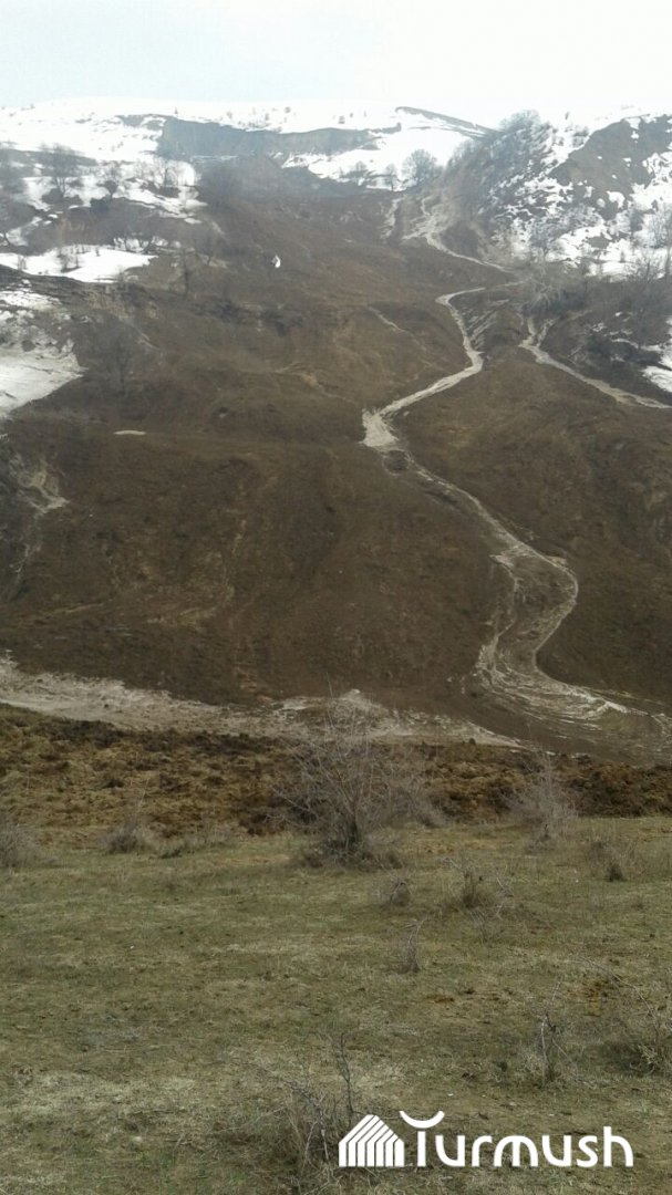
The large landslide at Nichke-Sai in Uzgen, Kyrgyzstan on 26 March 2017, via Turmush
.
Meanwhile, the AKIpress report includes a view of the upper reaches of the landslide:
The upper reaches of the landslide at Nichke-Sai in Ugen, Kygyzstan, via AKIpress
.
The landslide is interesting given that there is still extensive snow cover. Note that the scar appears to lie in a steep scar high on the slope, with the slide then entraining a large volume of material downslope. The material looks to be fine-grained, with no sign of boulders. Kyrgyzstan is affected by fairly frequent landslides in loess – who can forget this amazing video of a loess landslide from there in May of last year. I would speculate that this is another such example.
Previous posts on loess landslides:
- The location of the Kyrgyzstan loess landslide, as caught on that amazing video
- Do not miss this: video of a catastrophic landslide in loess in Kyrgyzstan
- The Abe Barek Landslide in Badakhshan, Afghanistan
- Badakhshan landslide in Afghanistan – a loess failure?
- Images of the Shanxi loess landslide
- Yaglidere – a dramatic landslide video from Turkey
24 March 2017
The Mitchell Creek landslide in British Columbia, Canada
The Mitchell Creek landslide in British Columbia, Canada
The Mitchell Creek landslide is a very large, complex failure that has developed in response to the retreat of the Mitchell Valley Glacier in British Columbia, Canada. In a paper just published in the journal Landslides, Clayton et al. (2017) describe how this very complex and large (more than 1 km wide and 1 km long) landslide started to develop sometime between 1956 and 1972 as the slope was debuttressed due to the loss of ice at the toe. Since then parts of the landslide have moved by 40 metres or more.
The Google Earth image below, collected in 2010, shows the landslide. The location is 56.525, -130.233 if you want to take a look. Note I have had to change the contrast in the image to make it easier to see. The Mitchell Glacier is at the toe of the slide, whilst tension cracks are clearly evident on the slope behind.:-
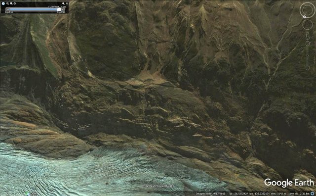
Google Earth image of the Mitchell Creek landslide in BC
.
In many ways though this landslide is easier to understand from the side, as this Google Earth image shows:
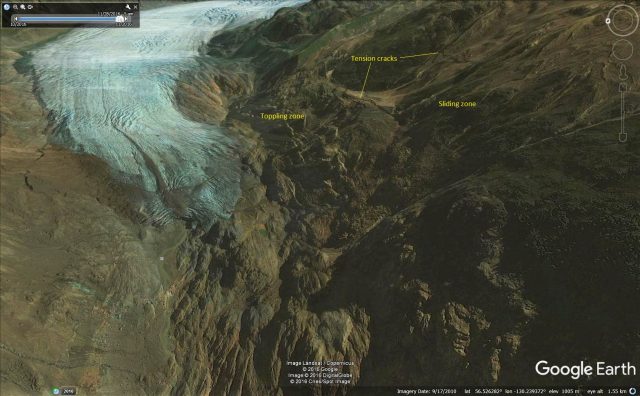
Google Earth image of the Mitchell Creek landslide, annotated with the major zones identified by Clayton et al. (2017)
.
The key to this landslide has been the retreat of the Mitchell Glacier, which can be seen in the image above. As the ice has melted the slope has been debuttressed – a well-known mechanism – and has started to deform. Clayton et al. (2017) have identified three major zones in the landslide – at the rear a sliding zone (in the images above the huge tension cracks are clearly visible), which is moving at about 20 cm per year on average. At the front there is a zone of toppling, which is moving much faster – about 80 cm per year. Between the two is a transition zone, in which movement rates are about 33 cm per year and in which the blocks are showing evidence of subsidence. Clayton et al. (2017) have used this to generate a really nice conceptual model of the landslide, below, which demonstrates in a very straightforward way the manner in which this landslide is developing:
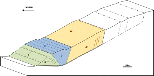
Simple conceptual model of the Mitchell Creek landslide, from Clayton et al. (2017)
.
If you compare this model with the Google Earth images above then the behaviour of the landslide becomes clear. It will be fascinating to see how this behaves in the next few years.
Reference
Clayton, A., Stead, D., Kinakin, D. et al. 2017. Engineering geomorphological interpretation of the Mitchell Creek Landslide, British Columbia, Canada. Landslides doi:10.1007/s10346-017-0811-1
22 March 2017
Comet 67P: a large landslide on another world
Comet 67P: a large landslide on another world
In a paper published in the journal Nature Astronomy (Pajola et al. 2017), Maurizio Pajola and a cost of dozens have recorded a large rockfall event occurring on Comet 67P / Churyumov-Gerasimenko. This event was recorded by the European Space Agency’s Rosetta mission over the period between 2014 and 2015.
The event started when, in September 2014, the team spotted a large (70 m long) fracture at the top of a cliff now known as Aswan:-
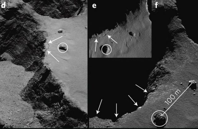
The rockslope failure on Comet 67P as revealed by the Rosetta mission, from Pajola et al. (2017). Images d and e show the fracture, image f shows the post-failure scarp
.
Pajola et al. (2017) report that on 10th July 2015 Rosetta captured a large plume of dust emanating from this area; and on 15th July 2015 a new image of Comet 67P showed that the rock slope had collapsed.
The volume of the rockfall is estimated to have been about 22,000 cubic metres, from a cliff that is 134 metres high. Before and after images of the rockfall site reveal an arcuate scar and a boulder field below:
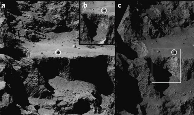
Pre- (a and b) and post- (c) failure images of the Aswan cliff collapse on Comet 67P, from Pajola et al. (2017)
.
Pajola et al. (2017) suggest that that collapse was driven by thermal changes in the rock mass, which is considered to be deeply fractured, as Comet 67P moved closer to the sun. However, the actual failure occurred at night, when the calculated thermal gradients were low. I wonder therefore if this is the first time that progressive failure has been observed on another body in the solar system?
In astronomical terms, the main interest here is that the rockfall mechanism provides an explanation for the outbursts of dust that have been observed to issue from the surface of Comet 67P.
Reference
Pajola, M. et al. 2017. The pristine interior of comet 67P revealed by the combined Aswan outburst and cliff collapse. Nature Astrononmy 1, 0092 (2017).
21 March 2017
Longdendale: dam building in an area of ancient landslides
Longdendale: dam building in an area of ancient landslides
Last week I was in a taxi being driven from Manchester airport back to Sheffield along the A628 road across the Pennine hills in northern England. As we were passing through the hills I was admiring the impressive landslides on the hillside above the Longdendale dams. These landslides can be seen on the southern (right) side of the valley in the Google Earth image below:
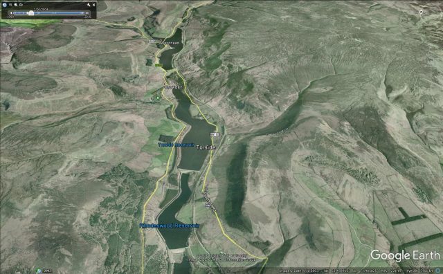
Google Earth image of the Longdendale dams and the landslides on the southern slope
.
These dams were constructed between 1848 and 1877 to provide water to the city of Manchester to the the west. These are early Victorian puddle core dams. With hindsight building such structures in an area of such obvious landsliding was courageous (though of course that was not known at the time); unsurprisingly the project hit major problems (which explains the very long construction time). To provide an illustration of the scale of the landslides, this is a Google Earth image of the Woodhead dam and reservoir, which is the highest of the sequence, with the spectacular ancient Lawrence Edge landslide on the slope above:
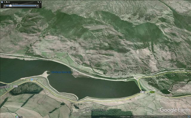
Google Earth image of the spectacular ancient landslide above the Woodhead dam in the Pennines of northern England
.
A book published by E.A. Labrum entitled “Civil Engineering Heritage: Eastern and Central England” provides a lovely description of the problems encountered with these dams. This book is available online. The first of the Longdendale dams to be constructed was Woodhead, shown above, which in the words of E.A. Labrun:
“…had geological problems in the form of the Lawrence Edge landslide on the south slope of the valley and faulted rock, heavily fissured, on the north side”
Whilst the dam was completed in 1851, it suffered severe leakage problems, requiring a new dam to be constructed. Downstream further problems with landslides were encountered during the construction of the Rhodeswood dam (this can be seen on the first Google Earth image above, but in this case I suspect the landslide is on the north side of the valley). The landslide was ultimately stabilised with drainage adits.
These dams and slopes are of course actively monitored now, and show no sign of instability. Further up the valley, the Millstone Rocks landslide is considered to be active but not dangerous.
20 March 2017
La Pintada landslide in Mexico: a new paper that links the slide and the cultural history
La Pintada landslide in Mexico: a new paper that links the landslide and the cultural history
In September 2013 a large landslide occurred at La Pintada in Mexico, killing 86 people. This landslide, which was triggered by Hurricane Manuel, is considered to be the worst landslide event in recent times in Mexico. I blogged about this landslide at the time, highlighting both the initial reports and the more detailed information. In a paper recently published in the journal Landslides, et al. (2017) provide a detailed description of the landslide. They have found that the landslide had a volume of about 125,000 m3 and occurred on a slope with a long history of instability. The local community is considered to have a high level of social exclusion; the majority of the population had not completed primary school and had no access to health services. Almost 12% had no toilet facilities. Thus, this was a community with a high level of vulnerability to natural hazards.
Google Earth has a decent image of the aftermath of the landslide and the extensive work that has been undertaken on both the slope and to rebuild the community:
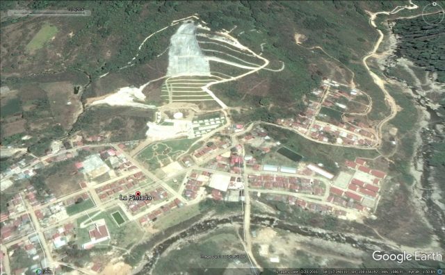
Google Earth image of the La Pintada landslide site
.
But the most interesting aspect of the paper is an analysis of the cultural history of the area in relation to landslides. In the paper, et al. (2017) note that the La Pintada slide was a reactivation of an ancient landslide complex, with a likely movement event in the 1940s but a history that extends back much further. The name La Pintada means graffiti, deriving from the presence in the village of a large boulder (which itself is probably derived from an earlier landslide) that bears several petroglyths (images carved on the rock). et al. (2017) describe these carvings as follows:
The repertoire of representations of the petroglyphs is reduced to a set of repetitive geometric forms mainly circles with different designs (concentric, connected with lines and divided with internal radial lines), rectangles with inner divisions, joined ellipses, networks and parallel wavy lines. There is only one figurative element, a zoomorph motive seen in profile: Its body is formed by wavy lines that connect to an ovoid head containing an eye, mouth and a pair of antennas topped with a circle, apparently a horned snake.
This for example is the animal described above, taken from the paper:
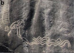
The figurative element – a horned snake – at La Pintada, from et al. (2017)
.
et al. (2017) note that the circles and wavy lines are generally considered to represent water, whilst the horned snake is likely to represent an element of the landscape. In petroglyths in Mexico the snake is known to represent water, or to represent the processes that cause catastrophic flows in steep catchments (i.e. debris flows). There is extensive documentation that in Latin America the snake can represent landslides as well, for example:
For the Chortí people of Guatemala, chicchanes are divinities who can appear as humans, huge snakes or in a form that is half human and half feathered serpent. At the beginning of the rainy season, the chicchanes, in the form of snakes, descend from the hills and enter watercourses, driving up their volume by water displacement. If many chicchanes swim downstream at the same time, the waters overflow and cause flooding. If a chicchan leaves a river and moves by land to reach another stream, her long body, snaking down the slopes of the hills, rolls away rocks and mud downslope, causing landslides (Wisdom 1961).
Thus, et al. (2017) suggest that the ancient carvings on the landslide generated boulder at La Pintada may represent previous landslide events that have affected this community.
Reference
Alcántara-Ayala, I., Garnica-Peña, R.J., Domínguez-Morales, L. et al. (2017). The La Pintada landslide, Guerrero, Mexico: hints from the Pre-Classic to the disasters of modern times. Landslides. doi:10.1007/s10346-017-0808-9
17 March 2017
Koshe, Ethiopia: the worst garbage dump landslide in recent years
Koshe, Ethiopia: the worst garbage dump landslide in recent years
The death toll from the terrible garbage dump landslide at Koshe in Ethiopia on Saturday is now known to have reached 115, with fears that more bodies may remain buried. The landslide occurred on Saturday when a section of the dump collapsed onto a slum built at the toe of the slope. The majority of fatalities are reported to be women and children. The most-informative set of images can be found in this CBS News article from a few days ago, including the image below of the crown of the landslide, which suggests that the crown of the landslide has a rotational component:-
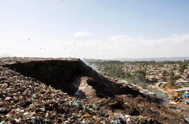
The crown of the Koshe landslide in Ethiopia, via CBS News and ZACHARIAS ABUBEKER/AFP/Getty Images
.
From this image the landslide looks to be a comparatively simple failure in an oversteepened slope. The image below, also via CBS News, shows the rescue operations further down the slope, which indicates that the lower reaches of the landslide may have behaved as an earthflow. Again, this is not unexpected:
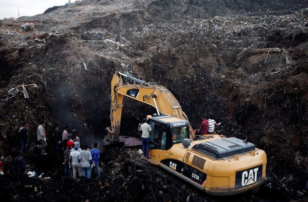
The lower reaches of the Koshe garbage dumpl landslide, via CBS News and REUTERS/Tiksa Negeri TPX Images of the Day
.
Africa Review has a good article on the possible causes of the landslide:
The people of Koshe lived in squalor of a degree that is uncommon in the city of four million people. Last year, the government tried to close the landfill and move it to a new location, but opposition from people living near the new site forced authorities to reverse their decision.
Addis Ababa’s construction boom didn’t leave Koshe untouched; a biogas plant is being built on top of the rubbish dump. Koshe residents who spoke to AFP blamed the landslide on the facility’s construction. They said bulldozers that packed down soil to make way for the new plant destabilised the hillside.
[Communications Minister Negeri Lencho] said he could not comment on the cause of tragedy, saying an investigation was under way. He had earlier said slum dwellers may have inadvertently caused the disaster.
Being buried in a garbage dump landslide is truly terrible. The survival rate is particularly low given the nature of the material and the potential for the waste to generate methane that can fill any spaces within the mass. Back in 2008 I wrote a blog post about the impact of garbage landslides, and our comparatively poor understanding thereof. In 2011 I posted about a terrible garbage landslide at Irisan in Baguio, Philippines.
9 March 2017
Chamba: an impressive set of landslide videos from Himachal Pradesh
A still from the Youtube video that shows a landslide occurring at Chamba in Himachal Pradesh, India
Chamba: an impressive set of landslide videos from Himachal Pradesh
A really impressive set of the three videos has been posted to Youtube showing a landslide at Chamba in Himachal Pradesh in India:
.
The landslide apparently occurred on the road that links Chamba with Saroo. Reports suggest that it occurred on Monday 6th March. I have seen no indications as to the trigger.
8 March 2017
Bucium Hill in Romania – an interesting landslide problem on a major road
Bucium Hill in Romania – an interesting landslide problem on a major road
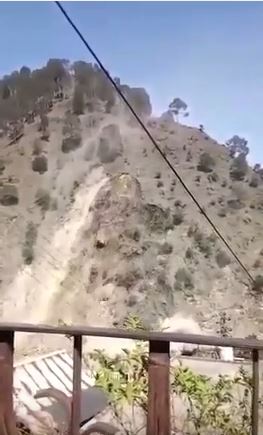
A very interesting landslide problem has developed on the AA1 motorway at Bucium Hill in the Transylvanian hills of in Romania. This section of road, was built between April 2011 and November 2014, In includes a very substantial cutting through Bucium Hill, with then transitions into a major viaduct, as seen below (via Youtube):
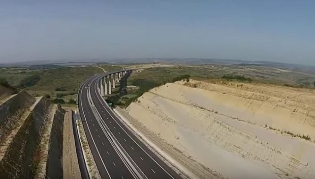
The cutting at Bucium Hill in Romania, via Youtube
.
Instability quickly developed in the slopes of the embankment, and the road was closed between September 2015 and October 2016. To deal with the problem the slope appears to have been successively regraded to a lower angle. The video below shows the site in September 2015 after substantial works on the north side of the road.
.
There is a series of these videos, from June 2016, December 2016 and February 2017. The most recent one, from last month, is embedded below:
.
This appears to show that the regraded slope is undergoing substantial deformation, and when compared with the video from December 2016 it appears that there has been considerable recent movement. There appear to be multiple types of landsliding occurring here. The most substantive movement appears to be occurring in the section shown below:
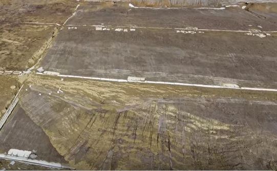
A section of deformed slope at Bucium Hill, via Youtube
.
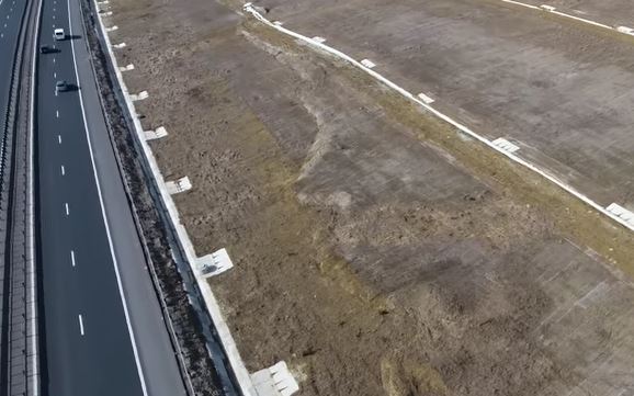
This image captures the toe bulge of the landslide, driven by substantial deformation at the crest:
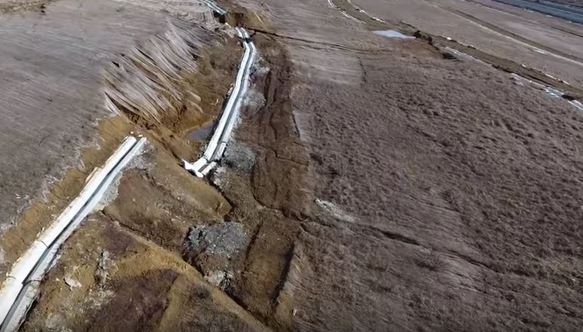
Slope deformation at Bucium Hill in Romania, via Youtube
.
Further along the slope there seems to be a much larger area of instability developing, albeit at an earlier stage:
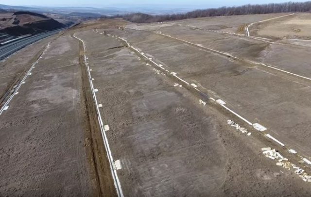
Possible signs of instability across the slope at Bucium Hill in Romania, via Youtube
.
These appear to be large, shallow failures in sandy materials. It is impossible to forecast behaviour without a detailed investigation of both the site and the materials – I assume that this is ongoing. It is slightly surprising to see no obvious signs of monitoring on the slope, but perhaps I have missed this. To my way of thinking, with major capital asset at the toe of the slope this is a site that deserved detailed investigation and observation.
I would welcome views and thoughts on the hazard, especially in light of how close some of the deformation appear to be to the edge of the road:
Deformation close to the edge of the road at Bucium Hill
 Dave Petley is the Vice-Chancellor of the University of Hull in the United Kingdom. His blog provides commentary and analysis of landslide events occurring worldwide, including the landslides themselves, latest research, and conferences and meetings.
Recent Comments