
7 March 2017
Oroville dam: multiple riverbank failures on the Feather River after the flow was abruptly stopped
Oroville dam: multiple riverbank failures on the Feather River after the flow was abruptly stopped
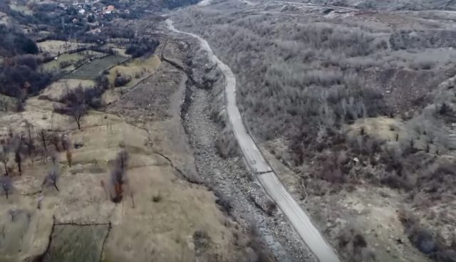
The San Francisco Chronicle has an excellent article about what happened next on the Feather River when the flow down the Oroville Spillway was abruptly stopped last week to remove debris from the channel:
When state water officials scaled back their mass dumping of water from the damaged Oroville Dam this week, they knew the riverbed below would dry up enough to allow the removal of vast piles of debris from the fractured main spillway. But they apparently did not anticipate a side effect of their decision to stop feeding the gushing Feather River — a rapid drop in river level that, according to downstream landowners, caused miles of embankment to come crashing down. With high water no longer propping up the shores, the still-wet soil crashed under its own weight, sometimes dragging in trees, rural roads and farmland, they said.
“The damage is catastrophic,” said Brad Foster, who has waterfront property in Marysville (Yuba County), about 25 miles south of Lake Oroville.
The farmer not only saw 25-foot bluffs collapse, but also lost irrigation lines to his almonds. “When the bank pulled in,” he said, “it pulled the pumps in with it. It busted the steel pipes.”
In the article, farmers describe losing substantial sections of their riverbank. For example one, Philip Filter at Live Oak describes losing most of the banks in his section, which extends over a kilometre. This image shows some of the damage:
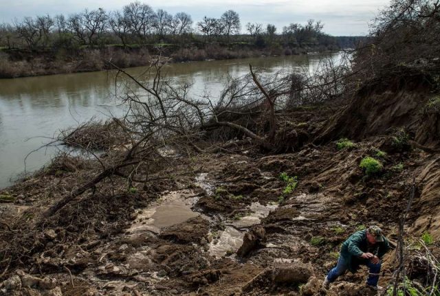
Landslides on the Feather Rover caused by the rapid drawdown of flow from the Oroville Dam, via the San Francisco Chronicle
.
Meanwhile on Twitter, Mike Luery of KCRA3 has provided another example of a riverbank collapse on the Feather River:
A riverbank failure on the Feather River, via Mike Luery of KCRA3 on Twitter
.
Riverbank collapse during rapid draw down is a well-known phenomenon – indeed riverbank failures are most likely on the falling limb of the hydrograph. As the river level rapidly falls the banks are left in a saturated state, which means that they are weak. But more importantly, they also have a hydraulic imbalance, which drives flow of water through the soil towards the river. This provides an additional force that reduces stability.
The problems of riverbank failure are well-described in the literature, and there is even a Wikipedia page that provides a detailed description. The tragedy is of course that riverbank failures represent a permanent loss of land, and the input of sediment into the river can have implications for the ecosystem. Drawing the river down more slowly means that the hydraulic instability is avoided, and the riverbank failures should not occur.
6 March 2017
Righa in Nepal: another landslide associated with a hydropower project
Righa in Nepal: another landslide associated with a hydropower project
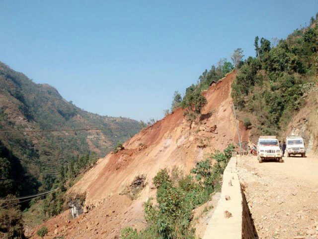
Over the weekend, various media outlets in Nepal reported a landslide near to Righa in Baglung district in Central Nepal, which briefly blocked the Daram River (although the blockage has now cleared). This landslide appears to have claimed the life of a local woman. Online Khabar reported the landslide as follows:
A landslide that occurred during the construction of a road for a hydropower project in Manewas of Righa-7, Baglung district, has partially blocked the Daram River. This has also shut the Mid-Hill Highway.
Two things to note here of course. First, that once again we see a significant landslide associated with a hydropower project (a point that I make frequently) and secondly, that this landslide was triggered by excavation. Interestingly, MyRepublica suggests that the problem may have been pipeline construction alongside the road for the HEP plant:-
According to Badri Sharma, chief division engineer at the mid-hill highway in Baglung, the ‘dry landslide’ was a result of the digging of land along the highway for laying pipes to produce energy by the Daramkhola Hydroelectricity Project Limited.
“When they asked for permission, we had told them to lay pipes toward the cliff as the edge of the highway was quite steep, ” said Sharma. He informed that clearing the rocks and land will take some time. “I have already asked the construction companies and Hydropower project working in along the highway to fix the problem and they assured to make the highway ready in about five-six days,” said Sharma.
Judging by images the landslide itself is quite significant in size (via the Gorkha Post):
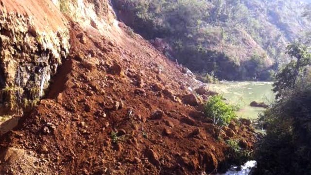
The landslide at Righa in Baglung, Nepal, via the Gorkha Post
.
There is also a collection of images of the landslide in a Youtube video that is available online:
.
Perhaps the most revealing element is this image of the headscarp area of the landslide at Righa:-
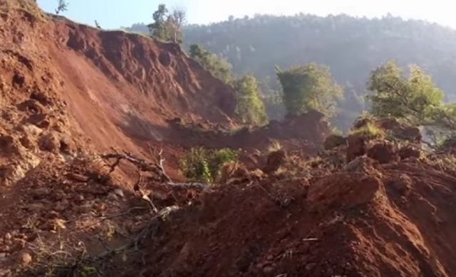
The headscarp area of the landslide at Righa in Baglung, Nepal, via Youtube
.
In common with the images of the landslide deposit, this suggests that the slide is in deeply weathered, dry soil. Such a landslide should in general be avoidable with good engineering practice, if excavation does indeed to be the cause of this landslide. There does appear to be some evidence that the landslide might be associated with a highway and associated works – this image from MyRepublica shows the crown of the landslide:
The crown of the landslide at Righa VDC in Nepal, via MyRepublica
.
1 March 2017
New images reveal the scale of damage to the Oroville spillway
New images reveal the scale of damage to the Oroville spillway
In the last few days the California DWR has shut off flow down the Oroville Spillway whilst they start to clear debris from the lower channels, which in turn should allow them to restart flow through the dam itself. This allows the level of damage to the spillway to be assessed properly – and there is no doubt that it is extremely serious. This image, from Reuters and Buzzfeed, provides an overview of the state of the Oroville Spillway now:
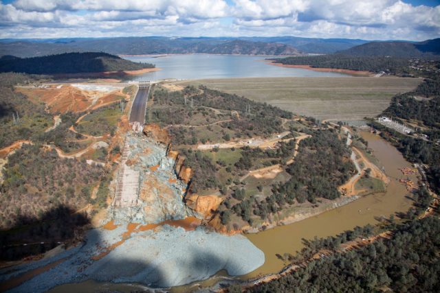
An overview of the Oroville Spillway, via Reuters and Buzzfeed.
.
The damage is better illustrated in the Buzzfeed image, which shows the enormous erosion that has developed on the margin of the spillway, and the very large hole that has been created in the midsection of the spillway itself:
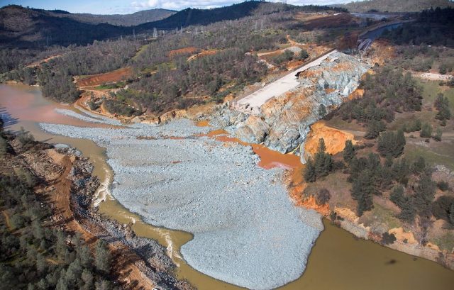
The scale of the erosion of the Oroville Spillway, via Buzzfeed.
.
The challenges of rebuilding the spillway are illustrated by this image of the upper section of the spillway. The new structure will need to be properly founded onto competent rock. It appears from this image that sections of the spillway that initially appear to be undamaged are in fact weakened:
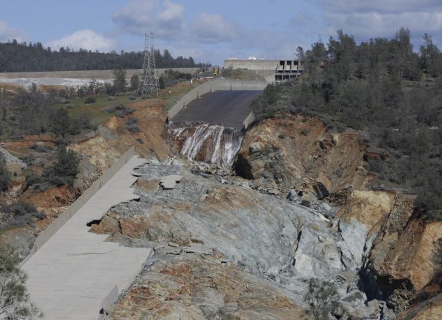
Damage to the main section of the Oroville Spillway, via Rich Pedroncelli / AP.
.
Meanwhile there is a very nice article in the Sacramento Bee that provides an overview of the crisis, and starts to probe what went wrong at the dam:
Some outside experts already have weighed in with theories as to why the chute, rated to handle 250,000 cfs, broke open Feb. 7 with a relatively modest 55,000 cfs pouring down.
Some, including Tullis, point to a phenomenon known as “cavitation,” in which the blast of tiny water bubbles gushing down the chute at 50 mph effectively jack-hammered holes in weakened sections of concrete. Others, such as Robb Moss, a professor of geotechnical engineering at Cal Poly San Luis Obispo, speculate that roots from trees growing along the chute expanded weaknesses in the concrete.
Rogers, the dam failure expert from Missouri, said the spillway may have had cracks that weren’t properly patched. He also theorized the failure may have been tied to California’s five-year drought: The aging spillway could have weakened as it underwent contractions due to the sudden heavy soaking following years of dry weather.
An investigation is underway. There is now enough spare storage capacity in the reservoir that the emergency spillway should not be needed again this year. The challenge will be to rebuild the main spillway in time for winter.
27 February 2017
NIWA maps huge submarine landslides triggered by the Kaikoura earthquakes
NIWA maps huge submarine landslides triggered by the Kaikoura earthquakes
NIWA, the National Institute of Water and Atmospheric Research in New Zealand, has put out a press release today regarding submarine landslides triggered by the Kaikoura earthquakes. We know that the main shock, and the aftershocks, triggered large numbers of landslides onshore. The picture on the seafloor was less certain, and is of course harder to determine. The interesting aspect of this is that offshore Kaikoura lies a submarine canyon – the Kaikoura Canyon – which is rather beautifully depicted in this NIWA press release from 2011:
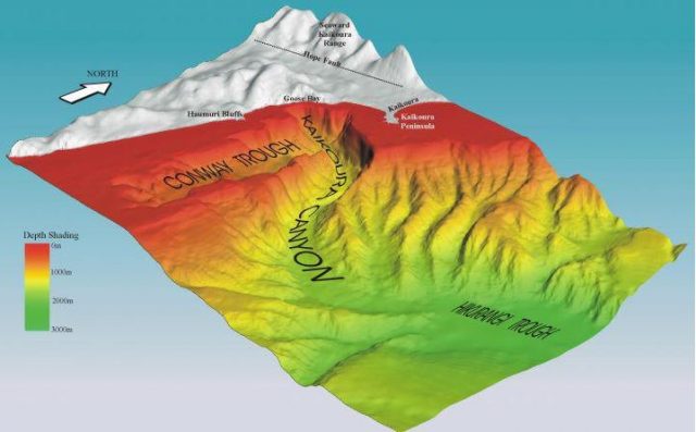
The Kaikoura Canyon, via NIWA
.
The interest in this canyon, and hence in its landslides, is more than merely academic. As the 2011 press release notes:
The Kaikoura Canyon is one of the most productive benthic (ocean floor) deep-sea habitats yet described, exceeding by 100 times the highest biomass measured for large invertebrates in at depths below 500 m at similar habitats, except for around hydrothermal vents. This productivity may contribute significantly to the surrounding ecosystem, which includes deep commercial fisheries for hoki and orange roughy.
The research showed very dense populations of large invertebrates, burrowing sea cucumbers, spoon worms, bristle worms and irregular urchins at depths of 900-1100 m.
It is this biodiversity that attracts the whales for which Kaikoura is known. The impact of large submarine landslides in the canyon is thus of critical importance.
NIWA have undertaken two research cruises to the canyon since the Kaikoura earthquake. They have found evidence of large landslides through the canyon:
…the latest post-quake surveys found not one instance of an organism living on or in the seabed. NIWA marine geologist Dr Joshua Mountjoy said a huge slipping event caused by the earthquake had removed the mud – where organisms had flourished – from the canyon’s upper slope.
“[Previously] everything at the head of the canyon was smooth and draped in mud. Our new data shows … almost every part of the upper slope had mud removed from it.”
The amount of material that had cascaded through the canyon was massive, he said.
“Some individual landslides are more than three times the size of the landslides that damaged the road to the north of Kaikōura.”
NIWA have released a before and after image of the landslides:
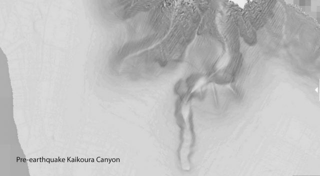
Pre-earthquake image of Kaikoura Canyon, via NIWA
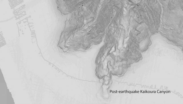
Post earthquake submarine landslides in the Kaikoura Canyon, via NIWA
.
Whilst the scale on these images is absent (which is frustrating), the amount of change is clear. It will be interesting to see how an inventory of submarine landslides compares with one for the terrestrial environment. I am not sure that such a comparison has been made previously. Others will be able to comment on the short and long term implications for marine organisms.
26 February 2017
Kakanj – an enormous mine waste landslide in Bosnia last Friday
Kakanj – an enormous mine waste landslide in Bosnia last Friday
On Friday of last week, an enormous landslide occurred at Kakanj in Bosnia. It is reported that this is a failure of a huge waste pile from the Kakanj Coal Mine. Reports indicate that 150 people have been forced to evacuate their homes in the villages of Ribnica and Mramor. The landslide has also blocked a river.
The best images that I have been able to find are contained in this drone footage that has been been posted on Youtube by Radio Sarajevo:
.
From the above video I have extracted this image, which shows the extent of the failed mass. I have drawn in the boundaries of the mine waste landslide as they appear on this image:
The Kanaj landslide via Radio Sarajevo and Youtube. The lines mark the approximate boundaries of the new landslide
.
This is clearly a very large failure. The image below shows the site on Google Earth (from 2013) – rough measurements from this image suggest something like 600 m in width and 800 metres or more in length. If we assume an average depth of 20 metres, which may well be an underestimate, that would give a volume of about 10 million cubic metres.
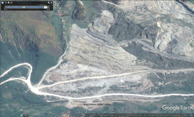
Google Earth image of the site of the Kakanj landslide in Bosnia
.
But I am not sure that the existing landslide is the whole story at Kakanj. The video shows that further along the slope, towards the main valley, there is another rather large break in the road:
Still from the Radio Sarajevo video of the landslide at Kakanj, via Youtube
.
I don’t know what this break represents, and I cannot speculate, but if I was investigating this slope I’d want to know. It could be unrelated. In the meantime the site needs investigation and monitoring. Fortunately, according to the Google Translate version of this article, there are drainage tunnels that are preventing the impounded water from building up.
24 February 2017
Ponzano di Civitella del Tronto: a highly destructive landslide in Italy
Ponzano di Civitella del Tronto: a highly destructive landslide in Italy
There has been a little bit of coverage in the media in the last few days of a highly destructive landslide occurring at Ponzano di Civitella del Tronto, in the Abruzzo region of Italy. This landslide, which is reportedly moving at about one metre per day for almost two weeks, has led to the permanent evacuation of about 35 houses, meaning that about 120 people have been relocated. The landslide is beautifully captured in this image from Blue Heart Planet:
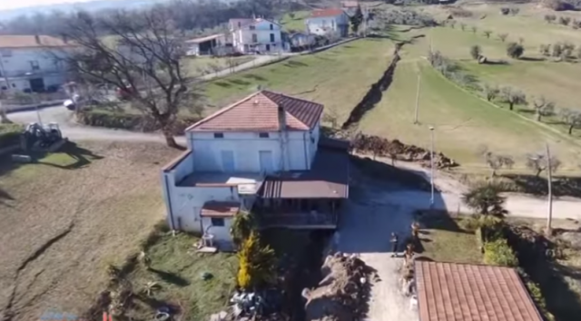
The landslide at Ponzano di Civitella del Tronto in Italy, via Blue Heart Planet
.
This area has been subject to earthquakes in recent months, which may have played a role in the instability. However, reports suggest that this is the reactivation of an ancient landslide, with the movement being induced by rapid snow melt in the last few weeks. My sense that this is a pre-existing, but until now inactive, landslide is probably correct. This is the same area as the image above from Google Earth, dated from last year:
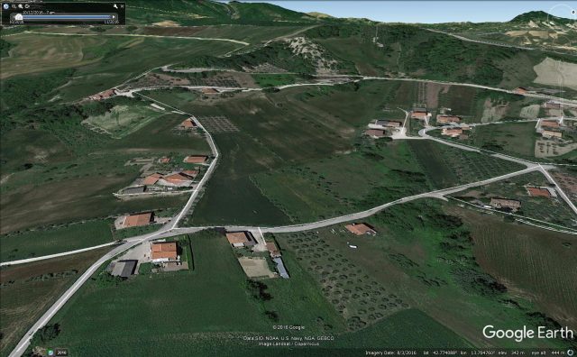
Google Earth imagery of the landslide at Ponzano di Civitella del Tronto from 2016
.
The head scarp of the ancient landslide can be seen just above the road that runs across the image, a quarter of the way down the image from the top. Note that there is another, larger, landslide head scarp to the right of this, with the two landslide bodies apparently merging on the slopes below so as to be indistinguishable. It is unclear to me as to whether the movement is occurring across all of this area, or just on the left-most landslide mass. There is high quality drone footage of the landslide available on Youtube that shows the magnitude of the damage to properties in the town as well the wider deformation. This footage was apparently captured by the local fire and rescue service:
.
Sadly, there is unlikely to be much that can be done to manage a landslide of this type and of this scale in the short term.
22 February 2017
The 170 km/h Sanxicun landslide in Sichuan Province, China
The Sanxicun landslide in Sichuan Province, China
On 10th July 2013 the catastrophic Sanxicun landslide, located at 30.917, 103.565, occurred during heavy rainfall in the Dujiangyan area of Suchuan Province in China. This was a large landslide – the estimated volume is 1.9 million cubic metres – and parts of the landslide travelled as a highly mobile flow for about 1000 metres. The landslide struck 11 buildings in a tourist resort, killing 166 people. I described this landslide on this blog at the time, but it is interesting that there was considerable uncertainty at the time as to the number of victims. The image below was posted by Xinhua the day after the disaster:
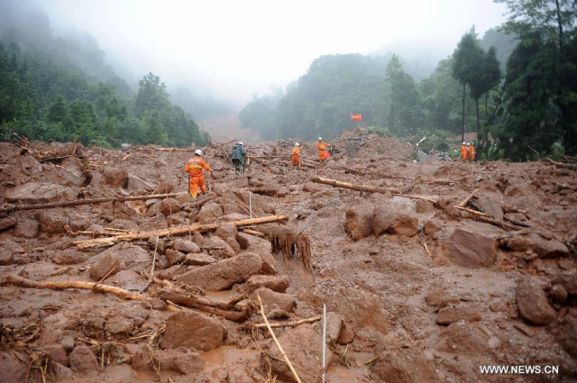
The aftermath of the Sanxicun landslide in Sichuan Province, China, via Xinhua
.
It is good therefore to see a paper, Gao et al. (2017), published in the journal Landslides that provides a proper description for this event. The site of the landslide is easy to see on Google Earth imagery, even though the scar rapidly revegetated:
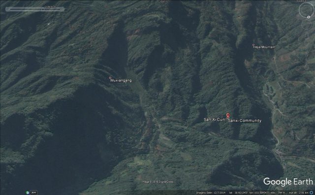
The Sanxicun landslide in China via Google Earth
.
This is an interesting landslide. It is clear that it was triggered by very heavy rainfall – Gao et al. (2017) note that recorded precipitation at one nearby weather station was 1059 mm, the heaviest rainfall recorded in this area since the start of records in 1954. But, this area had also been heavily affected by the 2008 Sichuan earthquake, which is thought to have contributed to the instability of the site. The main body of the landslide moved only 50-80 metres, but about 300,000 cubic metres turned into a mobile flow with two distinct flow paths (which can be seen above). The main body of these flows consisted of about 275,000 cubic metres that transitioned into a channelised debris flow. It is this portion that struck a tourist area, leading to the very high loss of life.
Interestingly, Gao et al. (2017) have modelled the landslide using the DAN3D system. They conclude from both these models and the field evidence that the maximum velocity of the landslide was about 47 metres per second, which is around 170 km/h (or around 105 mph). Thus, this was an exceptionally mobile landslide, explaing the high levels of damage. This means that the entire duration of the landslide was about 70 seconds.
I have noted before that one of the most insidious impacts of earthquakes in mountain chains is the increase in landslide hazard in subsequent rainfall events. This event is a dreadful illustration of that effect. Sadly, this hazard remains poorly appreciated.
Reference
Gao, Y., Yin, Y., Li, B. et al. 2017. Characteristics and numerical runout modeling of the heavy rainfall-induced catastrophic landslide–debris flow at Sanxicun, Dujiangyan, China, following the Wenchuan Ms 8.0 earthquake. Landslides doi:10.1007/s10346-016-0793-4
21 February 2017
Mega-landslides as a vehicle for colonisation of distant islands
Mega-landslides as a vehicle for colonisation of distant islands
One of the great challenges of biology is to explain colonisation of distant islands, and indeed continents, by animals that are too heavy to be carried aloft. Various theories have been proposed, such as rafts of vegetation carried by floods, but none seem to answer the question adequately. In a paper just published in the Journal of Biogeography, Garcia-Olivares et al. (2017) have come up with a novel solution to the colonisation problem – mega-landslides. Using a study of weevils in various of the Canary Islands, they hypothesise that very large landslides (such as those from volcanic flank collapse) create large rafts of floating organic material that can carry not just single individuals but whole populations to distant islands, where they can establish a new colony of the animal. The authors even include a nice image of the sequence of events from a landslide perspective:
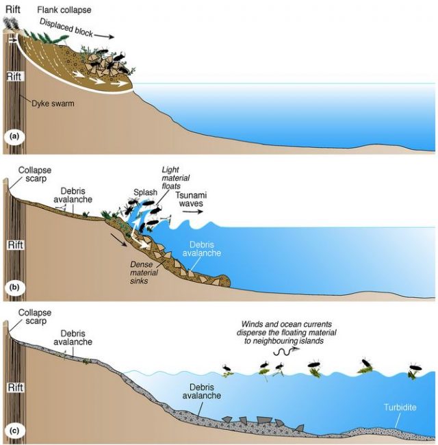
Mega-landslides as a mechanism for colonisation, from Garcia-Olivares et al. (2017)
.
The appealing thing about this theory is that it creates a testable hypothesis in terms of the population genetics. The authors have used DNA testing to demonstrate that for the weevils, the population and individual level genetics fit the hypothesis. They suggest therefore that the weevils that they examined on the island of La Palma are a part of the population located on on the island of Tenerife who were incorporated into the 500 cubic kilometre mega-landslide in La Orotrava, which occurred about 500,000 years ago. The weevils would then have been transported on rafts carried by the Canary Current between the two islands, before landing on La Palma to establish the new colony. Thus, argue the authors:
“mega-landslides are expected to promote the ocean deposition and rafting of significantly more organic material than that associated with the landslide itself, although the altitude of secondary deposition will be a function of the tsunami height. In the context of island biogeographical theory, for which colonization is a fundamental component, mega-landslides may be an important driver of colonization, mediated by ocean currents and archipelago geomorphology.”
Reference
García-Olivares, V., López, H., Patiño, J., Alvarez, N., Machado, A., Carracedo, J. C., Soler, V. and Emerson, B. C. (2017). Evidence for mega-landslides as drivers of island colonization. Journal of Biogeography. doi:10.1111/jbi.12961
20 February 2017
New landslide videos: San Bernadino National Forest, La Paz and the Big Sur
San Bernadino National Forest landslide video
One of a number of new landslide videos that have been published in the last few days comes from San Bernadino National Forest in Southern California, triggered by the latest in a procession of intense rainfall events in recent weeks. This is a very impressive video of a large landslide in the Forest Falls area. In many ways the most interesting aspect is the high energy mobilisation of the flow in the valley below the landslide, which was just caught by the person making the film:-
https://www.youtube.com/watch?v=ijDz5_BrlMY
.
Another, I think earlier, movement event of this landslide in San Bernardino National Forest was captured from a helicopter by Fox11. They report that this area is known as Slide Canyon:-
.
A still from this video captures rather well the extent of the landslide, which presumably mobilised in the later event:-
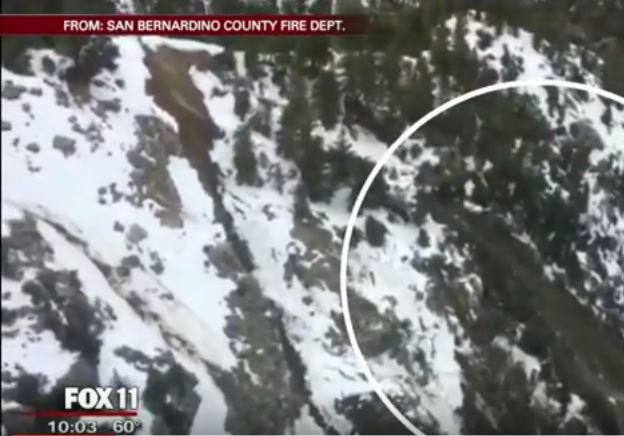
The tension crack at the head scarp (to the left of the white circle) of the landslide in San Bernadino National Forest, via Fox 11 and Youtube
.
A major landslide in La Paz, Bolivia
Meanwhile, the Wall Street Journal has published amazing footage of a major landslide that struck the outskirts of La Paz in Bolivia last week:
.
The still in the video above shows the aftermath of the landslide, which appears to have occurred in a succession of failures rather than one major collapse.
A landslide under the Pfeiffer Canyon Bridge in the Big Sur, California
Meanwhile, back in the USA this news report shows the effects of a landslide beneath the Pfeiffer Canyon Bridge in the Big Sur, California.
.
The damage to the bridge is spectacular:

Damage to the Pfeiffer Canyon Bridge in the Big Sur caused by a landslide beneath the bridge pier, via KSBW and youtube
.
It is hard to imagine that a structure with such serious damage can be saved, but Caltrans is undertaking inspections to determine the way forward. More rain is forecast.
14 February 2017
The enormous scale of the erosion problem at the Oroville Dam site
The scale of the erosion problem at the Oroville Dam site
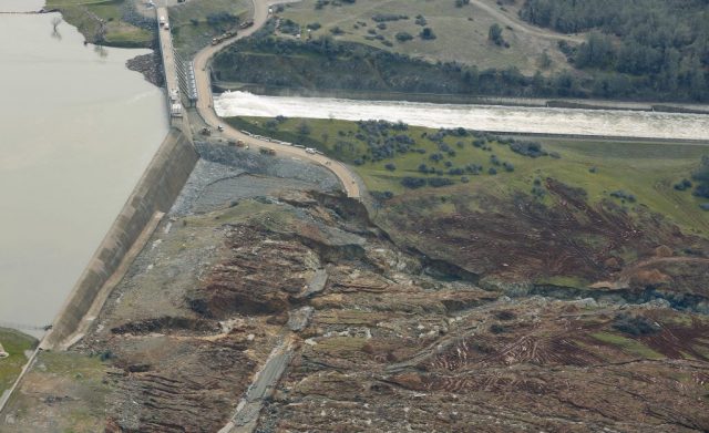
As the fairly desperate attempt continue to shore up the spillways at the Oroville Dam site, and to lower the water level ahead of the next rainstorm, better images are emerging of the scale of the problems on both spillways. If we start with the main spillway, which suffered the original erosion events last week, it is hard to appreciate the serious nature of the problems. However, this image (via the Sacramento Bee) from the weekend shows workers in the hole eroded in the main channel:-
The spillway hole at the Oroville Dam site, via the Sacramento Bee
.
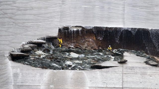
Of course the high flows down the spillway since then are likely to have exacerbated the problem significantly. Meanwhile, the headward erosion problem in the emergency spillway is now garnering most of the attention, primarily because of the potential for a major collapse. This image, from Hamodia, shows the nature of the erosion that has developed at multiple locations immediately down slope of the emergency spillway at the Oroville dam site:
Erosion below the emergency spillway at the Oroville Dam site, via Hamodia
.
The most serious problem appears to be a gully towards the bottom of the image, but there is also substantial amounts of erosion occurring on the other side too. The danger is of course that the these gullies will suffer headward erosion until they undermine the spillway lip. whereupon collapse may occur. One challenge is that the quality of the rock does not appear to be high, which accounts for the rapid erosion in both cases. This image, via Twitter, shows the nature of the bedrock with which the crews are dealing:-
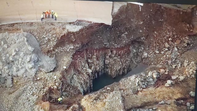
The nature of the bedrock in the spillways at the Oroville Dam site, via Twitter
.
The challenges are substantial. Fortunately, as before, there is no threat to the dam itself.
 Dave Petley is the Vice-Chancellor of the University of Hull in the United Kingdom. His blog provides commentary and analysis of landslide events occurring worldwide, including the landslides themselves, latest research, and conferences and meetings.
Recent Comments