1 February 2013
Landslides and rural roads in high mountains – an example from Nepal
Posted by Dave Petley
Accounting for changes in landslide patterns with time is very difficult. Collecting the underlying datasets is problematic in itself (still requiring mapping by hand in most cases) and, of course, landslides result from a combination of a whole range of natural and human factors, all of which change with time. It has been frequently postulated that one of the underlying causes of the increase in landslides in mountain areas in less developed countries is road building – indeed in a paper that I wrote with some colleagues a few years ago (Petley et al. 2007 – drop me a line if you want a copy) we proposed that inappropriately engineered road construction might account in large part for the increase in landslide impacts in Nepal over the last 20 years or so.
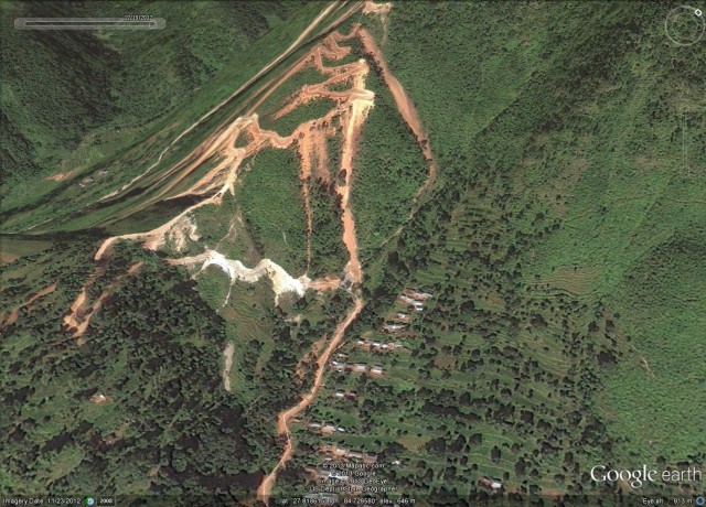
As part of the Earthquakes Without Frontiers project we will once again be working in Nepal over the next few years. I am genuinely delighted about this – Nepal is a quite wonderful country, but the landslide problem there is severe. The main aspect of our work will be to think about the threat posed by earthquake-induced landslides, and a major issue here is the way that road networks will be disrupted when a large earthquake occurs. So, this morning I was looking at the ways that road building has changed the landscape in Nepal in recent years, and came across this really interesting example from Central Nepal. The area in question lies close to the Prithvi Highway, which is the main access road from the southern plains through the mountains to Kathmandu. The rural road in question, which is in the very southeast of Gorkha District, is a small road that links to the main Prithvi Highway and passes through a settlement called Ghyalchok before climbing over the ridge, ultimately joining another road near a settlement called Darbung Phant (see Figure 1 below). The mountains here are large, but they are not the huge snow-capped high Himalaya to the north. The road w, which starts at about 300 m above sea level and climbs to about 1300 m, was presumably constructed to link the many ridge-top communities to the main road network, and as such is typical of thousands of roads being built in Nepal. The road, which is almost certainly unsurfaced, can be seen as a thin brown line on Fig 1.
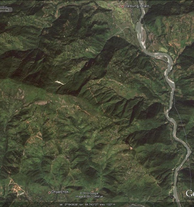
Fig 1: Google Earth image of the road in central Nepal. The road is the thin brown line that wins its way through the hills between the two settlements from bottom left to top right
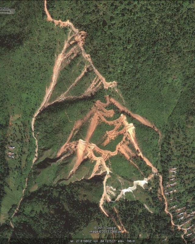
If you look carefully you should be able to see that in several places the road has a series of quite large landslides along its length. The most obvious set is in the bottom left corner:
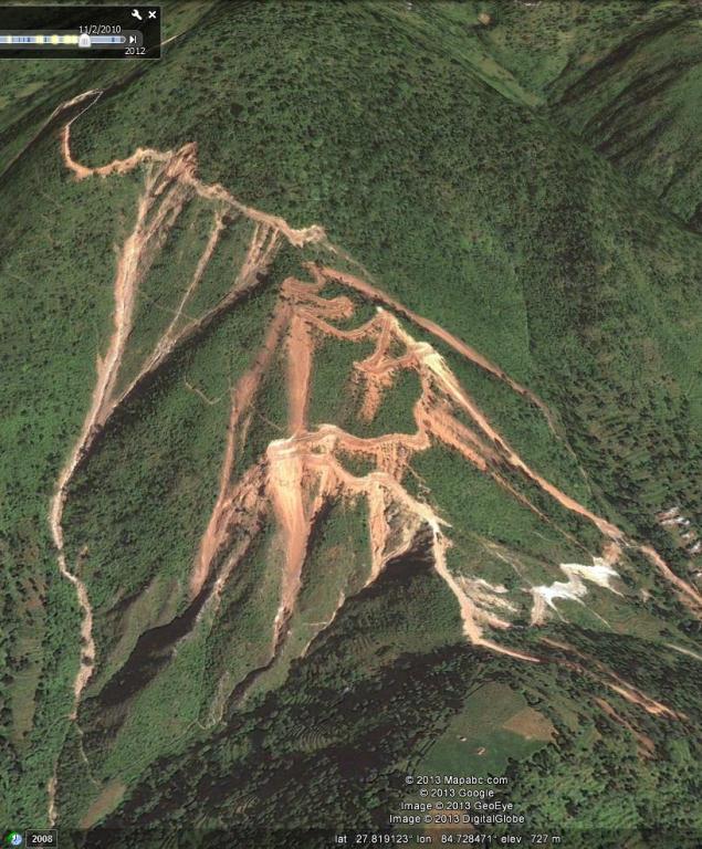
The nature of these landslides becomes quite clear when they are viewed draped on the digital elevation model (Figure 3). Note the way that some landslides triggered by the road have spilled onto the road itself further down, multiplying the problems:
This imagery was collected in February 2010. Interestingly, Google Earth also has an image from March 2009 (less than a year before), which was before the road was constructed. Fig. 4 shows the same perspective view of this imagery as in Fig 3. The line of the road is traced out on the image, but note that the road had not been constructed. At that time there was just a walking track across the hillside.
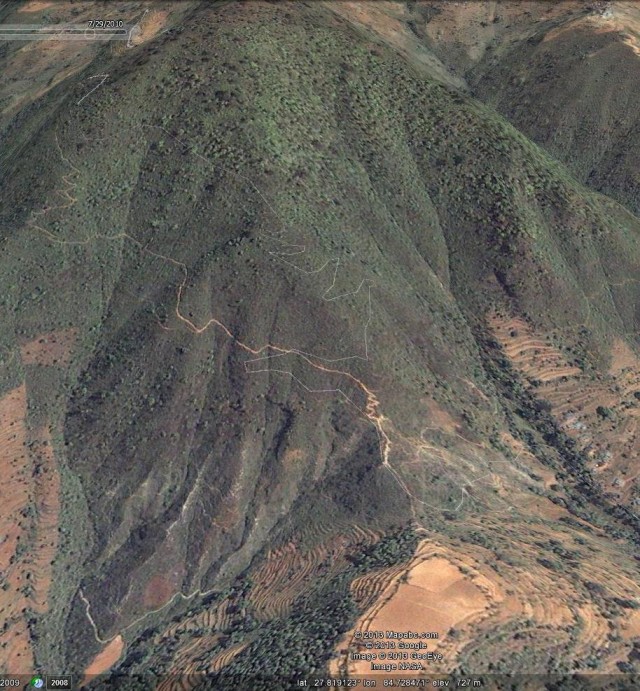
Fig 4: The 2009 Google Earth perspective view of the line of the rural road in Nepal. Note the absence of both the road and the landslides
The difference between the two images is startling. Before the road was constructed there were no landslides at this site. Clearly the slips are a substantial threat to the viability of the road, and will have serious impacts on the communities if they become dependent upon the road for their livelihoods. However, the threat is more serious than this I think because the two largest landslides runout perilously close to the road and the adjacent houses (Fig. 5):
In a cloudburst event, which occur occasionally during the monsoon, these landslides have the potential to turn into very devastating debris flows (such as the famous Hong Kong event of a few years ago, shown in the video below). In such conditions road users and the inhabitants of some of these houses would be at high risk. And of course we have no idea how these systems would behave in an earthquake.
This pattern is repeated right across Nepal. I am not against increased road building in the mountains. However, preventing these types of landslide problems is comparatively simple and inexpensive, and has the potential to improve both livelihoods and safety. If we are to reduce losses from landslides then it is this sort of problem that needs to be tackled systematically.
Reference
Petley, D. N. and Hearn, G. J. and Hart, A. and Rosser, N. J. and Dunning, S. A. and Oven, K. and Mitchell, W. A. (2007) ‘Trends in landslide occurrence in Nepal.’, Natural hazards, 43 (1): pp. 23-44.


 Dave Petley is the Vice-Chancellor of the University of Hull in the United Kingdom. His blog provides commentary and analysis of landslide events occurring worldwide, including the landslides themselves, latest research, and conferences and meetings.
Thanks Dave, very noteworthy article. For this issue, you can find my feeling in this article http://www.hils.org.np/ranjan/papers/Ranjan_Low-cost_road.pdf
Yes sir, its an impressive article showing vulnerable resources, increasingly threatened in recent years by negligence in road construction in rural Nepal. Great work Professor Dave using such simple tools!
Very informative article indeed, thank you!
I’m looking for VDCs in central hilly region to study on community resilience for landslides in Nepal. Also, is Barhabise bazaar (landslide prone side) in Sindhupalchowk or in Sankhuwasabha? I would appreciate your valuable suggestions.
Dear Dave, Thank you for article. I just visited this Darbung Landslide. In my point of view, the landslide in Darbung is slope failure and plane failure. There was landslide before the road according to locals. The landslide was started before 10 years. Now, it is inactive but the landslide can be active if there will be heavy rain.
Basanta
“preventing these types of landslide problems is comparatively simple and inexpensive” – is it “do not build roads in such places” or is it possible to build roads and avoid triggering landslides, without making it extremely expensive?
Our paper on “Roads and landslides in Nepal: how development affects environmental risk” addresses this issue. We find that- rainfall-triggered landslides are more than twice as likely to occur within 100 m of a road than the landslides generated by the earthquake. Good agricultural soils and vast network of informal roads are indication of more deveoped rural centres but these are also the places with the highest risk of landsliding.
Paper link:
https://nhess.copernicus.org/articles/18/3203/2018/