
19 April 2017
Losses from landslides in Colombia: the long term picture
Losses from landslides in Colombia: the long term picture
News is coming in today of further landslides in Colombia, with at least 14 reported fatalities in Manizales, where it is reported that at least 50 landslides have been triggered by up to 156 mm of rainfall. Some reports suggest that a further 23 people may be missing. This comes on top of the recent Mocoa landslide, in which at least 300 people were killed.
Back in 2012 I posted about landslide losses in Colombia, noting that:-
If we are to reduce the impact of landslides across South America then Colombia needs to be a priority country.
In 2015 Sergio Sepulveda and I analysed landslides in Latin America in a paper that was published in Natural Hazards and Earth System Sciences. The paper is open access, so it is free to download. I posted a summary of the paper at the time. In that paper we also noted that landslides inflict a heavy toll in Colombia.
Of course in the almost five years since my 2012 post, Colombia has gone through considerable change, including the end of the conflict between FARC and the government. This is therefore a timely moment to take another look at landslide losses there.
The graph below shows the cumulative total number of landslides and landslide fatalities in Colombia, based on my long term landslide fatality database. Note that the data only records landslides that cause loss of life. This does not include the landslides in the last 24 hours in Mazinales.

Cumulative losses from landslides in Colombia since 2004, based on my landslide fatality dataset
.
Sadly, the data suggests that there is no sign that losses from landslides in Colombia are reducing, and it is clear that the cost of landslides in Colombia is high. The good news is that they do not seem to be getting worse either, although the recent losses are clearly the worst since I started to collect this data in 2004.
In my post in 2012 I noted that rainfall in Colombia is heavily affected by the ENSO cycle. Interestingly, the large El Nino of 2014-15 did not drive an increase in landslide losses. However, the rainfall events that the country is currently experiencing are being ascribed to a “coastal El Nino” event. This is not a term that I have heard before; it will be interesting to see if this scientifically valid, and if so if it might provide greater insight into the variable triggers of landslides in South America.
18 April 2017
The Almaluu-Bulak landslide in Kyrgyzstan: amazing new Google Earth imagery
The Almaluu-Bulak landslide in Kyrgyzstan: amazing new Google Earth imagery
Possibly the most astonishing landslide video of 2016 showed the Almaluu-Bulak landslide in Kyrgyzstan. I wrote about it at the time, and also managed to pin down the location. The video is worth seeing a second time:
.
This was the second, larger, event in the sequence, both of which occurred on 27th April 2016. One person was killed.
Last month, the Google Earth Blog wrote about this landslide. The prompt was new imagery in the tool that captures the before and after situation of this landslide, and the adjoining area. And wow, this is worth a look. The easiest way (assuming you have Google Earth) to view the images is via this KML file. They have even mapped some of the landslides, though a quick inspection shows that there are many, many more. Indeed this is a landscape that is dominated by landslide processes.
But, in terms of the Almaluu-Bulak landslide itself, the imagery is fantastic. This is the image collected in November 2016:-
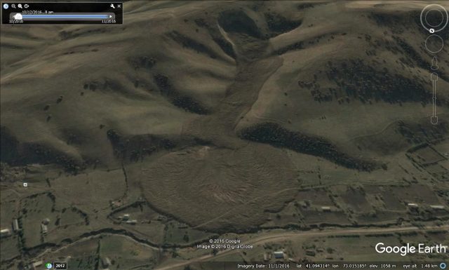
Google Earth image of the Almaluu-Bulak landslide in Kyrgyzstan
.
It is a most beautiful example of a flowslide. The deposit at the toe is very similar to the deposits seen at the toe of some flume experiments when the flume toe is planar, unrestricted surface, although others will be able to better comment on this.
A really interesting aspect is the before and after comparison of the source area. This is an image after the event:
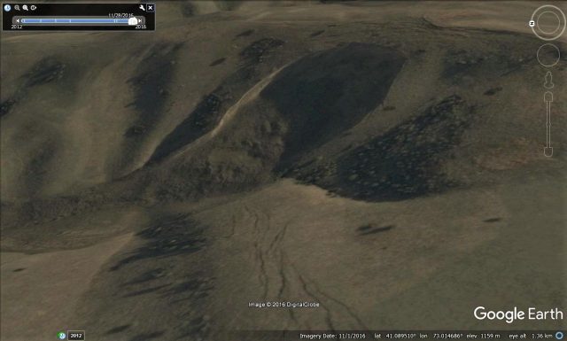
Google Earth imagery of the aftermath of the Almaluu-Bulak landslide in Kyrgyzstan
.
Note the cracks in the hillslope in the foreground, and behind the crest of the landslide scar. But look at this image, taken two months before the failure event, from the same perspective:
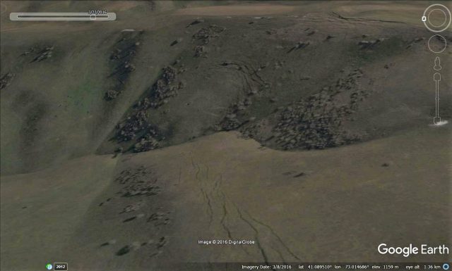
Google Earth imagery of the source of the Almaluu-Bulak landslide, taken two months before the failure
.
Note the multiple arrays of cracks in the source area. This was a landslide that was developing over a long period. Interestingly, these cracks do not correspond to the current back scar. But we know that two failure events occurred in close succession. I would hypothesise that these crack define to source of the first landslide, whilst the second occurred because of toe release by the first.
The large cracks behind the scar suggest that there is a risk of a third, possibly even larger, event at this site, but that can only be ascertained with a more detailed analysis that involves fieldwork.
17 April 2017
The Meethotamulla garbage dump landslide: an avoidable tragedy?
The Meethotamulla garbage landslide: an avoidable tragedy
The number of victims recovered from the Meethotamulla garbage dump landslide in Sri Lanka is now 28, with at least 30, and possibly as many as 100, people still missing. Rescue operations continue, although the reality is that it is unlikely that anyone will be recovered alive now. Meanwhile, controversy has developed over the blame for the tragedy. This Reuters report says:
The police said they were investigating whether the landslide was natural or man-made.
This is not in question. There is nothing natural about this landslide in any way. The question is not whether it was natural, but whether it was foreseeable (note not this is not the same as asking whether it was predictable, as I noted in a post in December). To me the answer is hinted at by this image, published in the Sri Lanka Daily Mirror in 2014, showing the dump at that time, but an investigation is needed to answer the question properly:
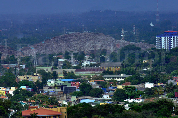
Sri Lanka Daily Mirror image of the Meethotamulla garbage dump, taken in 2014.
.
Compare this image with this one, published by LankaeNews, showing the aftermath of the failure:
The aftermath of the Meethotamulla garbage dump landslide, fro Lankenews.
.
There is a very interesting article on Groundviews website about the garbage dump, its impact on local residents, and of course the landslide. On the Meethotamulla garbage dump itself, it says of the local residents:
One thing they all had in common was their distaste for the nearby dump. It was clearly visible from most of the lanes – swarming with flies, with the occasional pig rooting through the garbage. Even if you couldn’t see it, you could certainly smell it. The people I interviewed said the stench was particularly unbearable when it was hot, forcing many to close their windows and doors to avoid the smell.
Worse, respiratory diseases and skin rashes were quite common thanks to the proximity of the dump.
But the article also quotes a 2010 piece in the Sunday Leader that is deeply worrying:
[CMC Commissioner Badrani Jayawardena] claimed that this site is the only one of its kind to be maintained. “No where in Sri Lanka is it maintained like this,” she said. “Everyday we put a layer of soil on top of the garbage to seal it. We do it step by step but within five days we get the area covered. The reason it looks like such a huge dump is because of the soil as well.”
Putting layers of soil on the garbage way well have been wise in terms of containing the odours, but may have been dangerous in terms of the stability of the dump. This sounds to me to be a recipe for creating planes of weakness, increasing the likelihood of failure. The investigation, if done properly, will need to look into this as well.
In the short term, in addition to completing the recovery operation, there is an urgent need to start to make the dump stable. The peak summer rainy season in Colombo is in May, with an average of almost 400 mm rainfall over the month.
16 April 2017
The Meethotamulla garbage dump disaster in Sri Lanka
The Meethotamulla garbage dump disaster in Sri Lanka
At the time of writing, the loss of life from the landslide at the Meethotamulla garbage dump in Colombo, Sri Lanka is 26 people, with reports varying as to how many more victims have yet to be recovered. A press release from the Ministry of Defence in Sri Lanka, which is leading the response, indicates that 145 houses have been buried. This is of course the second major garbage dump landslide this year.
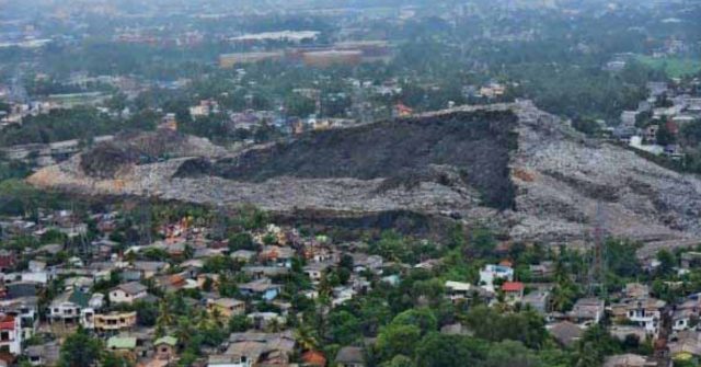
The most informative images that I have seen of Meethotamulla landslide were tweeted by Azzam Ameen (a BBC reporter) on Saturday. They were apparently collected by the Sri Lankan Air Force. This image shows an overview of the Meethotamulla site, with the failed side of the dump clearly shown by the freshly exposed garbage:-
Sir Lanka Air Force image of the Meethotamulla garbage dump landslide, as tweeted by Azzam Ameen
.
According to Google Earth the dump is about 380 metres long. From the image it appears that the landslide is a pseudo-rotational slip that has formed a very steep back scar (further work is going to be needed to make this site safe before the rainy season begins). The slide appears to have engulfed houses along a large section of the toe. The interaction with the buildings is complex, as this image (from the same source) shows:
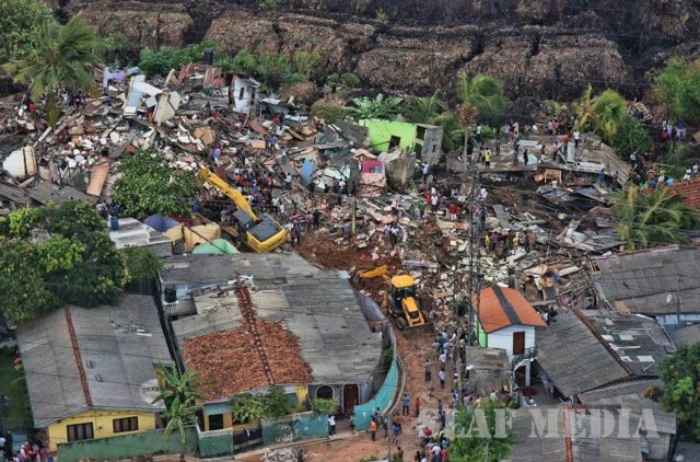
Image of damage caused by the Meethotamulla garbage dump landslide in Sri Lanka. Image from the Sri Lanka Air Force, tweeted by Azzam Ameen.
.
It appears that the debris has over-ridden some buildings, but bulldozed others to incorporate them into the landslide:
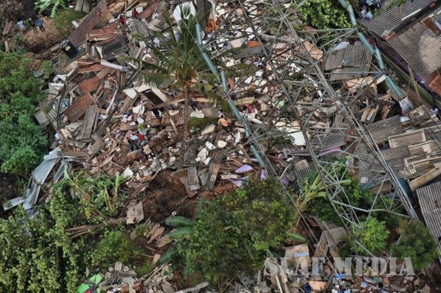
Image of damage caused by the Meethotamulla garbage dump landslide in Sri Lanka. Image from the Sri Lanka Air Force, tweeted by Azzam Ameen.
.
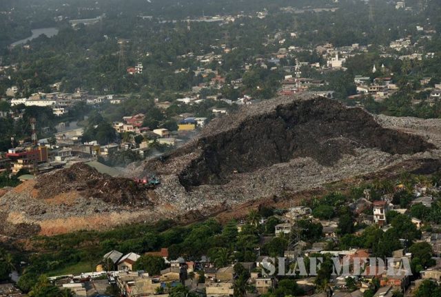
This disaster did not come out of the blue. This article, from August last year, highlights grave concerns about the stability of the Meethotamulla site. It includes this image, which clearly shows that mass movements were occurring in the garbage:
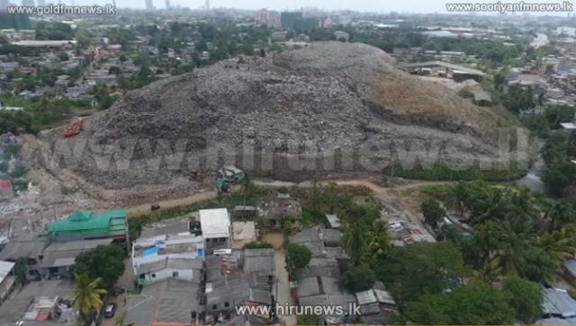
Hiru News image from August 2016 that clearly shows instability in the Meethotamulla garbage mound
.
It is undeniable that this site was unsafe. The garbage mound is clearly too high and too steep, inviting a rotational failure. With houses so close to the toe of the slope the hazards were severe. I am no expert on garbage dump landslides, but it seems likely that the decay of the waste will cause it to weaken with time, increasing the risk. In addition, in a humid monsoonal climate, the pore pressures are also likely to increase with time (as is well-documented in embankments, for example). Thus, the stability of this slope was probably decreasing even without the addition of further garbage.
This is another case in which we know and understand the hazards, but fail to manage them. The results are once again tragic.
13 April 2017
Shimla and Idaho: two new, and very different, landslide videos
Shimla landslide video
An excellent video has been posted on Youtube of a landslide that occurred at Shimla in Himachal Pradesh in India on 7th April. The landslide has occurred on a slope that appears to have been cut as part of a construction project that is in the foreground:
.
The apparent lack of slope support at this site seems bizarre given the materials from which this slope is formed:
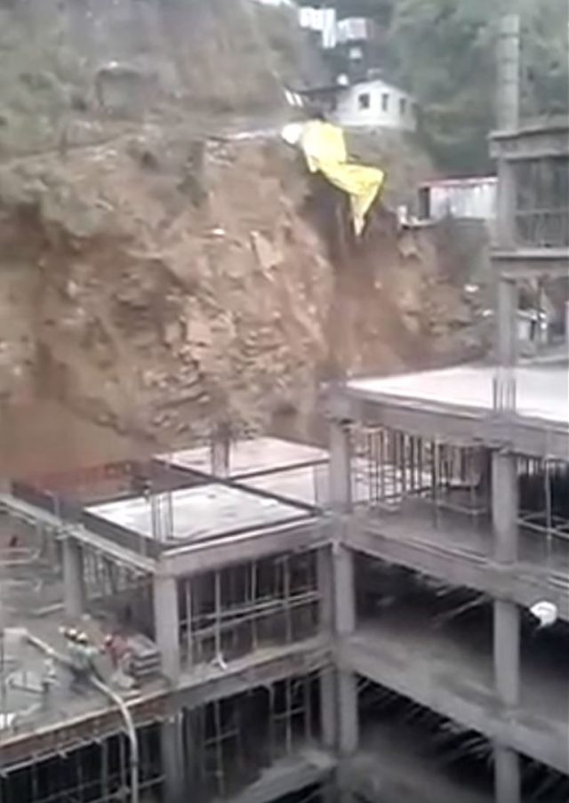
Landslide on a cut slope at Shimla in India, via Youtube
.
I have to admire the coolness of the construction workers, who seem remarkably unconcerned about this developing slope failure. Amazingly, the main failure event was captured from a second angle as well:
.
It appears the the highway is the road that links Shimla and Chandigarh. The construction site may be the base station for a ropeway and a shopping mall.
A gentle landslide from Idaho
Meanwhile, the Weather Channel has posted a most elegant video of a smaller landslide that occurred above a road in Idaho:
.
I have rarely seen such a gentle, almost balletic, landslide. Amazingly, it did not even cause the light pole at the toe of the landslide to topple as it was gently moved across the road. The Idaho State Journal has an account of this landslide:
ITD crews were on scene with cameras rolling as a hillside broke free and covered a section of U.S. 95 south of Bonners Ferry on Friday, April 7. In the video, you can see tons of mud, rocks, and trees slide down, pushing two layers of concrete barriers off the road. Overall, 800 cubic yards of debris slid onto the road. Thanks to quick action of ITD crews on scene, no one was injured by the slide. ITD Land Surveyor Mathew Wilson, who took the video, was assessing the hillside stability. He heard popping and cracking and knew another slide was imminent. Thinking quickly, the flaggers on scene stopped traffic and just three minutes later the hillside gave way. ITD crews cleared the debris from the road Friday evening. Additionally, crews dug out an extra 600 cubic yards of dirt beside the road to create a channel for water to run.
9 April 2017
Papamoa: a brilliant video illustrating the mobility of landslides
Papamoa: a brilliant video illustrating the mobility of landslides
One of the hardest things to explain about landslides is the ways in which changes in the structure of soils can cause dramatic reductions of strength, and thus increases in mobility. A brilliant video has been posted to Facebook by Emma Kapua that illustrates this point as never before, I think. This landslide occurred in the Papamoa Hills of New Zealand, one of many landslides triggered by the remnants of Tropical Cyclone Debbie as it passed over the country last week:
The force of nature! Papamoa Hills Regional Park 6th April 2017 after heavy rain from ex. TC Debbie.
Posted by Emma Kapua on Thursday, 6 April 2017
.
You will see that this starts as a classic, small rotational failure. It is clearly formed from intact soil at this point:-
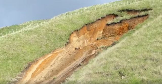
Papamoa: the early phase of the landslide caught on video by Emma Kapua and posted to Facebook.
.
As the landslide goes around the circular shear surface it fragments rapidly, and changes phase:-
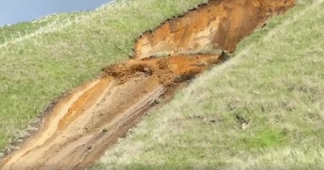
The fluidisation of the Papamoa landslide, as caught on video by Emma Kapua and uploaded to Facebook
Thereafter the landslide behaves as a fluidised mass, and thus accelerates rapidly down the steep part of the slope:-
The final phase of the Papamoa landslide, as captured by Emma Kapua and posted to Facebook
.
Understanding the processes that allow some soils to respond in this way has been a key aspect of landslide research, and of course it is essential to appreciate these mechanisms if the likely impact of future landslides is to be determined. It is the failure to understand that landslides can show this behaviour that can lead to an under-appreciation of the hazard that some landslides can pose. Clearly once a slide is moving in this way then the destructive potential is very high.
6 April 2017
A tragedy foretold? The Mocoa landslide was anticipated in 2014
A tragedy foretold? The Mocoa landslide was anticipated in 2014
In Colombia, the authorities are now shifting from rescue to recovery in the aftermath of the Mocoa landslide. The government has ordered a formal inquiry into the landslide, and the events that led to it, amongst claim and counter-claim about the importance of deforestation and cultivation in the destabilisation of land. A good article in New Scientist covers many of these aspects. This draws attention in particular to an article that was published in a local newspaper in 2014, written by Jorge Kuaran from the National College of Journalists. This article, which is in Spanish, appears to have been accessed so many time in the last 24 hours that the site has exceeded its bandwidth, but an archive is available on the Wayback Machine. It is a really fascinating piece that highlights the dangers of the gully that runs through Mocoa, in the aftermath of a false alarm in the town. This is a corrected Google Translation from the original Spanish:
Stories like the one of Armero, could be repeated in Mocoa, capital of Putumayo; But this time it would not be the fault of the nature, but of the lack of responsibility of the people who hold the authority in the municipality and the department. Nature, after all, has been warning and announcing a tragedy for more than two years.
The article provides additional detail about the concerns, which centre around landslides that have both blocked the channel and accumulated debris that can be mobilised into a debris flow:
Thanks to the evidence obtained by www.notifronteras.com , through the same officials of the municipal administration, it can be observed that on the Quebrada La Taruca located to the north-west of the urban area of Mocoa, and that borders with the basin of the ravine El Conejo, there has been a slide of stone, plant material, soil and other materials, about 150 meters wide by 300 meters high, which is on the channel of the ravine La Taruca … This implies by simple reasoning that the area where the great amount of material of the slip is located, has highly unstable ground by the groundwater that runs and that at any moment can generate an avalanche of proportions unimaginable given the topography of the land, that has a quite steep slope, since the head of the ravine starts more or less to a height of the 1,700 m and arrives at Mocoa that is located to a height of about 600 m with a distance of the head of the ravine to the urban area of about 7 kilometers, which means that when an avalanche is formed at the site of damming and sliding, by the force that the mass movement takes, it can reach Mocoa in less than 20 minutes, no Giving time to organize any massive evacuation of the families bordering the basin of the Taruca creek and the Sangoyaco river.
The article includes images and even videos of the debris choking the channel down which the Mocoa landslide flowed:
Debris in the La Taruca channel that was the source of the Mocoa landslide, via Jorge Kuaran
.
This is a chilling prediction of what appears to have happened. Jorge Kuaran is clear about the risk to the people of Mocao:
A tragedy of the proportions that we imagine has at risk the life of a large number of [people from Mocoa], since there are many neighborhoods or urban population living on the banks of the Sangoyaco river…I see a nonexistent emergency plan nor measures to overcome a catastrophe of considerable magnitude, it is necessary for the authorities of the municipality and the department of Putumayo to take serious steps in this regard.
Meanwhile, Mongabay has a good article (also in Spanish) that examines the causes of the Mocoa landslide disaster. This includes the following image of the catchment upstream of Mocoa, which supports the idea that this disaster was caused by shallow landslides that became a channelised debris flow:
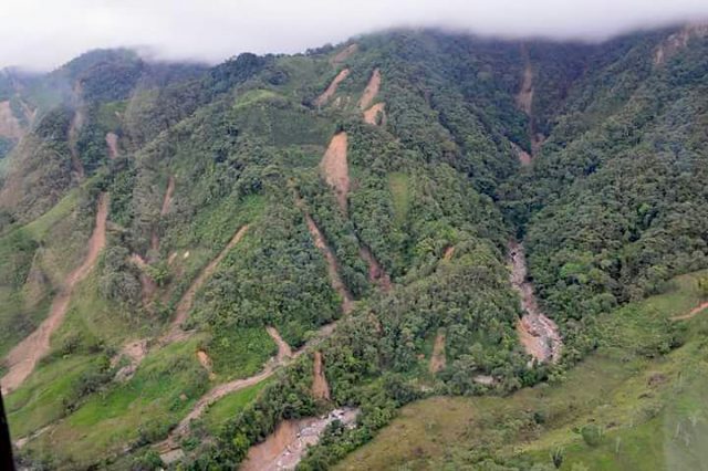
Shallow landslides upstream of Mocoa, via Mongabay and Corpoamazonía.
.
The scale of this disaster is now becoming clear – the number of bodies recovered is now known to be 293, with 314 people believed to be missing. This would lead to a total of 607 fatalities.
5 April 2017
Mocoa debris flow: analyses of the event
Mocoa debris flow: analyses of the event
The loss of life from the Mocoa debris flow is now known to have exceeded 290 people, of whom 144 are reported to be children, whilst the search continues for those who are missing. NASA Earth has now published an analysis of the rainfall event that triggered the landslide, noting that:
IMERG data were used to estimate the amount of rain that fell near Mocoa, Colombia, during a seven-day period from March 26 to April 2, 2017. IMERG indicated that area rainfall totals during the week were frequently greater than 80 mm (3.1 inches). The analysis also showed the locations of heavy rainfall that extended from east of Mocoa into the high mountains that surround the city.
Meanwhile the ESA has released a slightly weird interpretation of “land movement”, based on an analysis of Sentinel 1 data byI. Parcharidis, of the Harokopio University of Athens :-
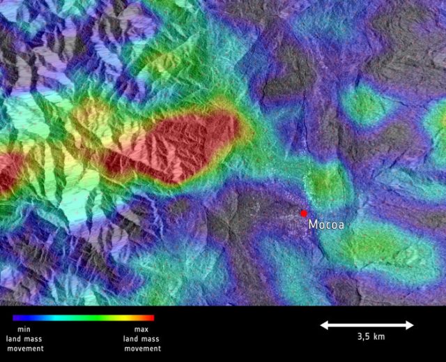
Sentinel 1 analysis of “land movement” close to Mocoa, processed by I. Parcharidis, Harokopio University of Athens, via ESA
.
The red area cannot be a single landslide, and thus is not a simple explanation for the Mocoa debris flow. I wonder if this is area something to do with canopy wetness, or soil moisture, and thus indicates where a cloudburst type of rainfall event might have occurred? Others, who know more about radar data, may be able to comment. Meanwhile IBTimes has an excellent if heartbreaking gallery of images of the aftermath of the debris flow, which includes this image of the boulders transported by the debris flow:
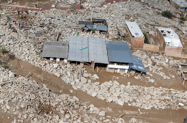
The aftermath of the Mocoa debris flow. Photo by Jaime Saldarriaga/Reuters via IBTimes.
.
Exactly what happened upstream of Mocoa remains unclear, but this image appears to support my hypothesis that the Mocoa debris flow might have started as one or more shallow landslides that transitioned into a channelised debris flow.
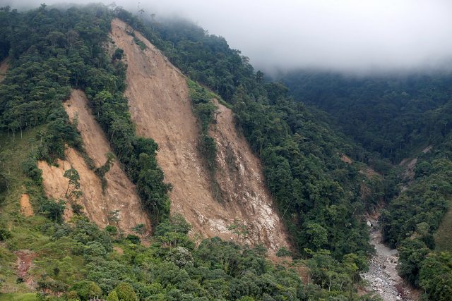
Landslides upstream of the Mocoa debris flow. Photo by Jaime Saldarriaga/Reuters via IBTimes
These events can be unbelievably violent – the best video of one of these events remains the Lantau debris flow of 2008:
.
It is hard to imagine that ploughing through the town. Unbelievably dreadful.
4 April 2017
Mocoa: the cause of the tragic debris flow in Colombia
Mocoa: the cause of the tragic debris flow in Colombia
The tragic debris flow at Mocoa in Colombia at the weekend has garnered considerable media attention internationally. As of today, the total number of people who are known to have died is 273, many of them children with varying reports of the number missing. Recovery operations continue on the site, and Colombia has mobilised large-scale resources to provide assistance.
There are some aerial images of the track of the debris flow online that allow the catchment to be identified. This image, via Fox6, in particular clearly identifies the section of town devastated by the debris flow:
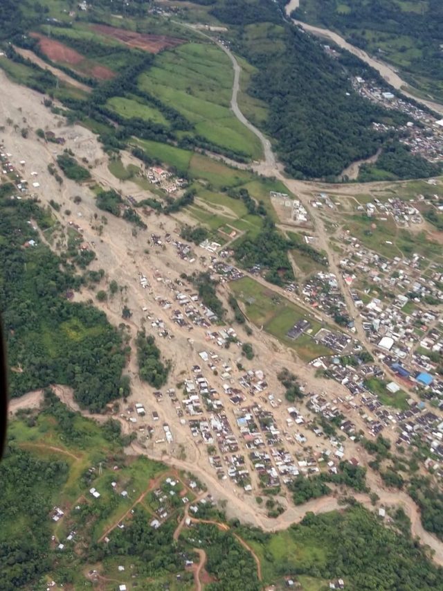
Aerial image of the aftermath of the Mocoa debris flow in Colombia, via Fox6
.
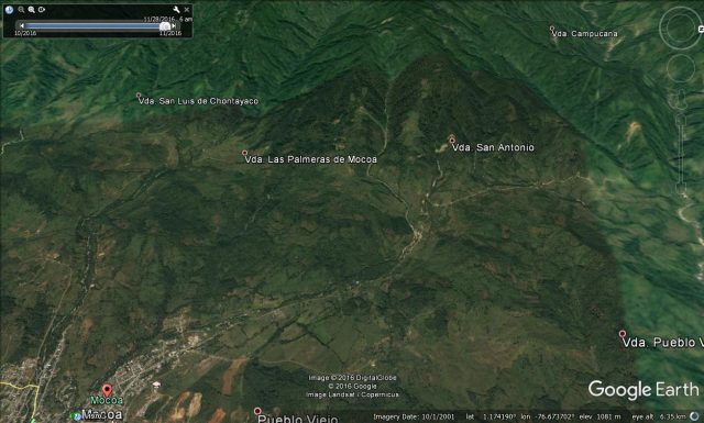
This is a Google Earth image of the same area of the town. Unfortunately the image is from 2001 – it is clear that there has been a great deal of development since, with many of the houses that have been inundated post-dating the image.
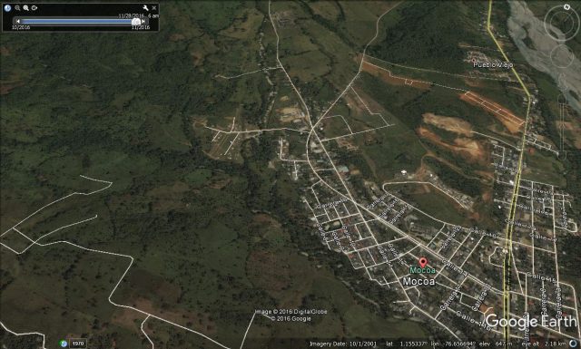
Google Earth image of the area affected by the Mocoa debris flow in Colombia
.
It appears that many of these newer houses may have been built on the flood plain of the river. However, more interesting in the imagery of the catchment upstream of the area affected – i.e. of the source of the debris flow itself. This is a Google Earth perspective view:
Google Earth image of the catchment that generated the Mocoa debris flow. The image is from 2001.
.
The catchment is not large – the river length is about 10 km but it is steep. Perhaps the most interesting aspect is the obvious existing shallow landslides high in the catchment:
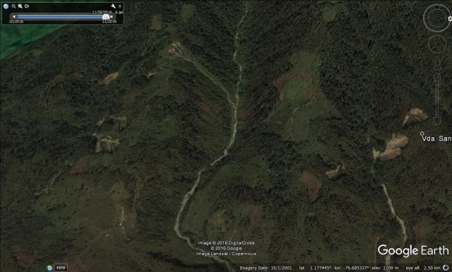
Shallow landslides high in the catchment at Mocoa, based on the 2001 Google Earth image.
.
So a good working hypothesis for this event is that one or more shallow landslides slipped into the channel to become a channelised debris flow, which then entrained large volumes of debris from the channel to create the monster that struck Mocoa. An alternative, but less likely cause might be that a landslide blocked the channel, and then collapsed to release the debris. A good quality satellite image will reveal the truth in due course.
31 March 2017
Point Dume: an interesting new landslide video from California
Point Dume: an interesting new landslide video from California
Point Dume is, according to Wikipedia,
“…a promontory on the coast of Malibu, California that juts out into the Pacific Ocean. The point, a long bluff, forms the northern end of the Santa Monica Bay. Point Dume Headlands Park affords a vista of the Palos Verdes Peninsula and Santa Catalina Island. Zuma Beach lies to its immediate northwest.”
A video has been posted on Youtube showing a comparably large landslide that occurred close to the car park, apparently on 25th March 2017. The landslide was apparently shot by Eric Cotsen, although there is no more information available. The video has been uploaded in slow motion format, which is both irritating and interesting:
.
The site appears to be the area of cliff shown on the Google Earth image below:
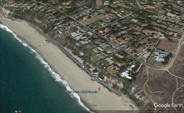
The approximate location of the Point Dume landslide, as shown on Google Earth.
.
The development of failure is quite interesting, with a large number of small collapses, followed by a large scale movement on the right hand side of the mass, which them leads to the major collapse on the left hand side. This is transition is captured in the image below:
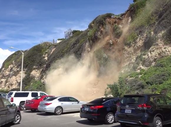
Still from the Youtube video of the Point Dume landslide.
.
This may be one of the highest quality landslide videos captured to date.
Other recent landslide video posts
- Chamba: an impressive set of landslide videos from Himachal Pradesh
- New landslide videos: San Bernadino National Forest, La Paz and the Big Sur
- Bova Marina – an interesting retaining wall failure video
- A terrifying and tragic mudslide video from Arequipa in Peru
- The Mount Sulzer avalanches: the amazing video
- Big French Creek: a high quality new landslide video
- A great new landslide video: Piz Cengalo
- Uttarkhand and Siliguri: two new landslide videos from India
- Two further videos of the Kleine Gaisl rockfall in Italy
- Freshwater: a nice landslide video from the Isle of Wight
- Illgraben debris flow video
- Gangotri and China: three fascinating new landslide videos
 Dave Petley is the Vice-Chancellor of the University of Hull in the United Kingdom. His blog provides commentary and analysis of landslide events occurring worldwide, including the landslides themselves, latest research, and conferences and meetings.
Recent Comments