
21 February 2023
Manutuke: a near miss landslide from Cyclone Gabrielle in New Zealand
Posted by Dave Petley
Manutuke: a near miss landslide from Cyclone Gabrielle in New Zealand
News of the landslides triggered by Cyclone Garbrielle in New Zealand continues to emerge, assisted by cloud-free conditions that are permitting satellite imagery to be collected. The NZ Herald has an interesting story about a large landslide in Manutuke, situated in the Gisborne District of North Island. The landslide is thought to be the largest failure triggered in the region – and it is an impressive event. The article includes this image:-
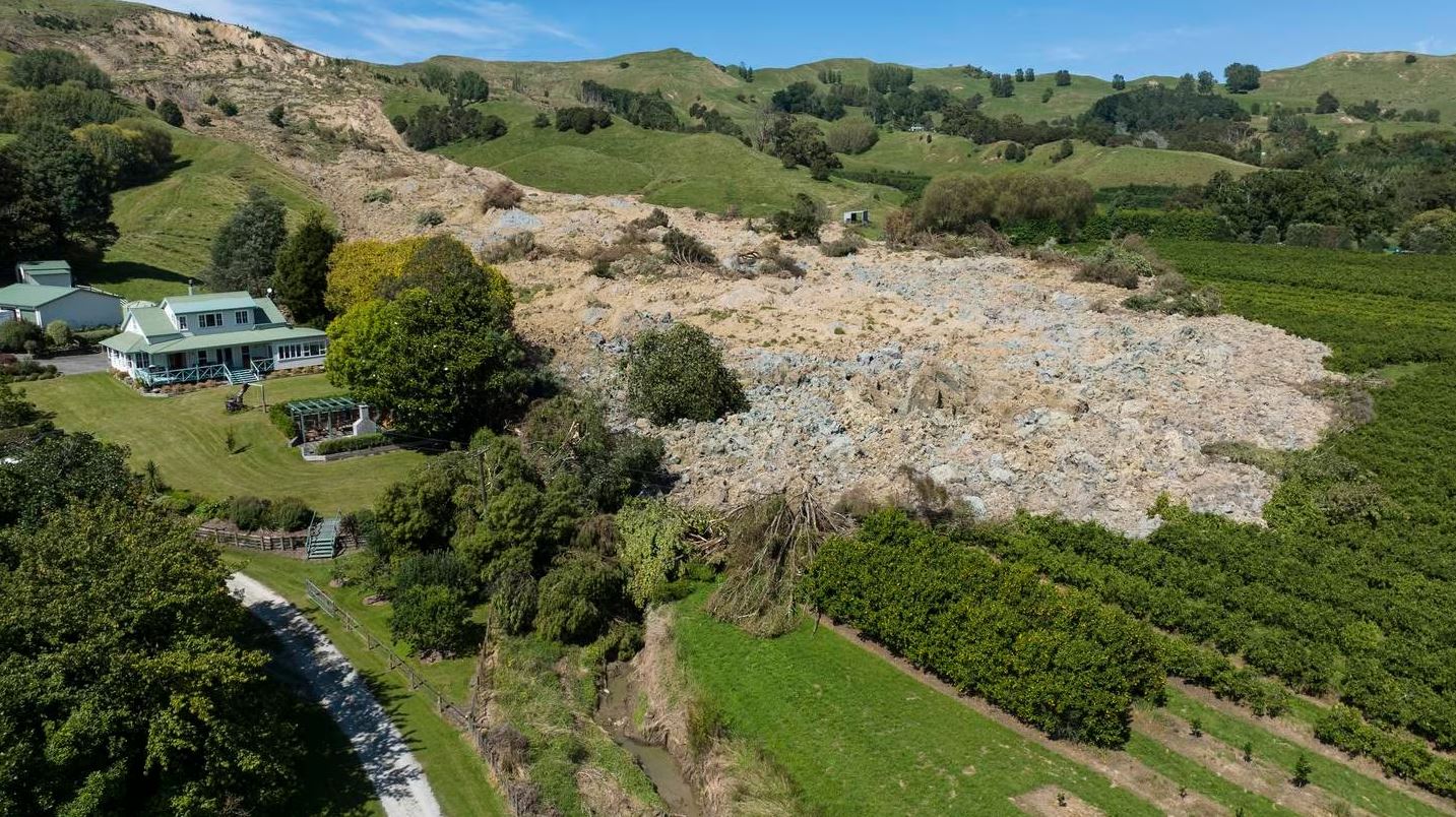
The large landslide at Manutuke in New Zealand, triggered by Cyclone Gabrielle. Image by George Heard / NZ Herald.
.
As the image shows, the landslide missed the house by a small margin. The NZ Herald article provides some detail:
Clive, 69, and Helen, 58, Foster have been living back at their property on Taurau Valley Rd for a few days since the massive rocky slip filled in a 20 metre deep valley beside their property just after 6pm on Tuesday.
“It’s pretty amazing, aye? It’s huge. Our boundary is just down here… Basically 99 per cent of it missed us, you know what I mean,” Clive Foster said of the downhill effects of Cyclone Gabrielle.
“We just said ****, we’re both alive, no one got injured, the house is all functioning like it was last week, it’s all fine. Really speaking, it’s great. What the hell? We’re alive. It’s just a mess.”
The rate of movement was slow, according to the article, in keeping with the earthflow typology of the landslide. The house has been red stickered – i.e. it cannot now be occupied, presumably because of uncertainty about the likelihood of a further failure.
The landslide at Manutuke can be seen on Planet imagery:-
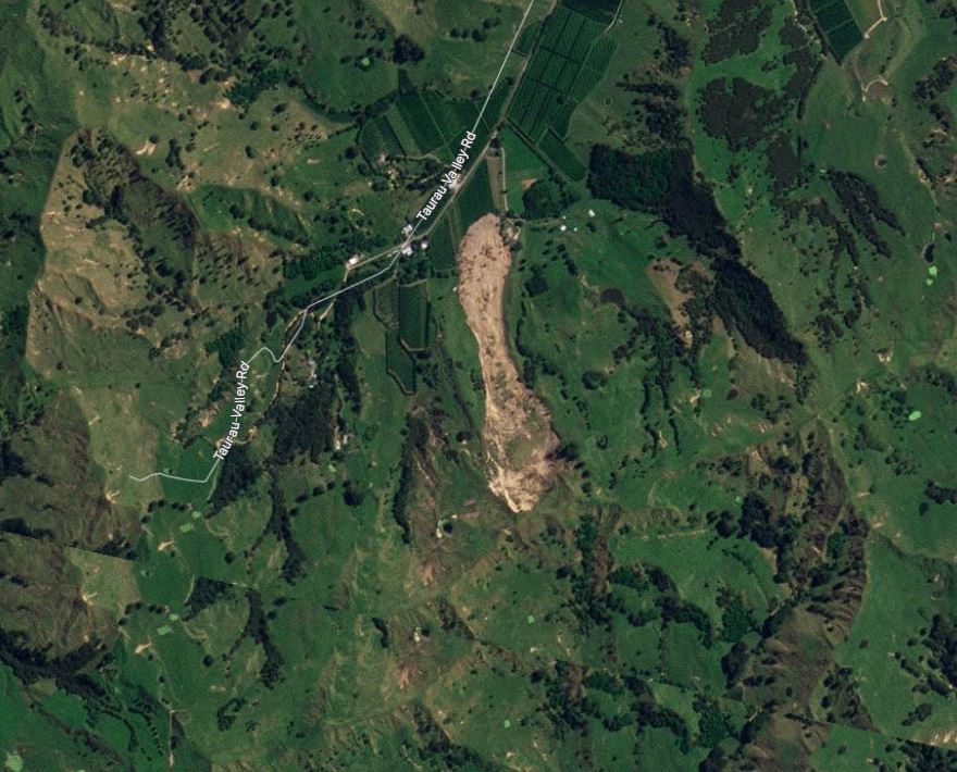
Satellite image showing the landslide at Manutuke. Image copyright Planet, used with permission. Image dated 19 February 2023.
.
The crown of the landslide is in the south, so the house is in the north-east extent of the landslide. The landslide is almost exactly 1 km long. The location of the landslide is [-38.730, 177.878].
This is just one of many thousands of landslides triggered by the cyclone. On Twitter, this helicopter image has been posted showing landslides in the Wairoa region:-
https://twitter.com/Infideliter2022/status/1627501994331230214
.
Whilst the image is unverified (and the claim of dozens of bodies is also not being reported elsewhere), it appears to show hundreds of shallow landslides. Imagery from Planet in the Wairoa area suggests that this is indeed the case:-
Satellite imagery showing landslides in the Wairoa area, triggered by recent rainfall. Image copyright Planet, used with permission. Image dated 20 February 2023.
.
The level of landslide events is similar to that caused by the infamous Cyclone Bola in 1988, which also triggered large numbers of shallow failures.
.
Reference and acknowledgement
Planet Team (2023). Planet Application Program Interface: In Space for Life on Earth. San Francisco, CA. https://www.planet.com/
 Dave Petley is the Vice-Chancellor of the University of Hull in the United Kingdom. His blog provides commentary and analysis of landslide events occurring worldwide, including the landslides themselves, latest research, and conferences and meetings.
George Heard’s image is amazing. I wonder if they will start to use detailed topography/DEM to restrict or zone building in future.
dLL is [-38.7247,177.8748,170] First two are dLat Long, (with -ve) to mark the starting point and the 170 is the bearing (degrees)
With other steep slopes around I’m surprised that there are not more large failure.
Just to note that there are a few factual issues with the story in the NZ Herald but it doesn’t change the size of the landslide. The dozens of bodies at Wairoa is grossly incorrect. There are isolated pockets of intensive “Bola-Style” landsliding in the Wairoa District but elsewhere is fine. The damage to the North Clyde suburb in Wairoa was due to flooding not landslides. Quite a few large landslides in the Gisborne/Tairawhiti region the critical one being in the Mangahauini river where a landslide dam threatens Tokomaru. Further north the large Waiorongomai landslide dam that formed in Cyclone Hale remains stable.