
10 February 2023
GeoNet information about recent landslides in New Zealand
Posted by Dave Petley
Geonet information about recent landslides in New Zealand
The recent prolonged heavy rainfall in the northern part of New Zealand triggered large numbers of landslides, some of which caused extensive damage. GeoNet is New Zealand’s wonderful natural hazards monitoring and response organisation. Working under the GeoNet banner, the landslide team at GNS Science has been collecting information about the landslides triggered by the rainfall. They have posted some details of their investigations on the GeoNet site – it is worth a look.
In terms of Auckland, the team reports that:
“They found small shallow landslides to be common across most of the hills, with the occasional larger more impactful landslide. Rockfalls and landslides were frequent across the coastal cliffs of Auckland, with numerous buildings affected. Inland there are multiple buildings impacted by landslides.”
They have provided images of some of the landslides, including this one:-
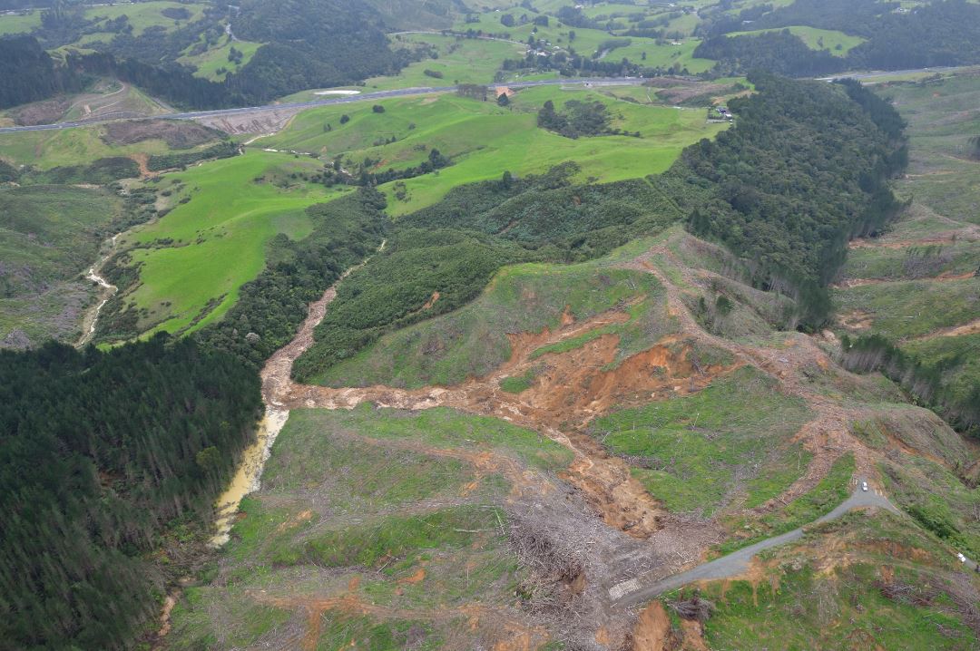
A landslide in the Auckland area of New Zealand, triggered by the recent heavy rainfall. Image by the GNS Science landslide team, via GeoNet.
.
This is a fascinating landslide in its own right, with multiple source zones. The debris has coalesced into a channelised flow with a long runout. Note that the main channel is blocked and a small lake has formed. The timber on the site appears to have been felled comparatively recently.
There is a brilliant 3D model of this landslide – a fantastic teaching resource.
In the Waikato and Bay of Plenty area, the GeoNet / GNS Science team has recorded c.160 landslides. They describe them thus:
“Many of the landslides around Tauranga Harbour occurred on steep coastal slopes composed of sedimentary deposits. Inland, most of the landslides were associated with road cuts, steep river valleys, forestry clearance, and weathered volcanic rock. Around the Coromandel Peninsula, the spatial occurrence of landslide activity was highly variable, but mostly concentrated in areas with sedimentary rocks, especially where forest cover was absent or where slopes had been steepened by roading or coastal erosion . In both Tauranga and Coromandel Peninsula, a small number of landslides occurred within native forest cover, associated with particularly steep slopes. Several slopes only partially failed, with large cracks visible above the landslide scars, or with partly displaced debris visible on the slopes. These ‘incipient’ landslides are likely to become sites of further slippage, especially in subsequent rainfall events.”
Again, there are some great images, including this one:
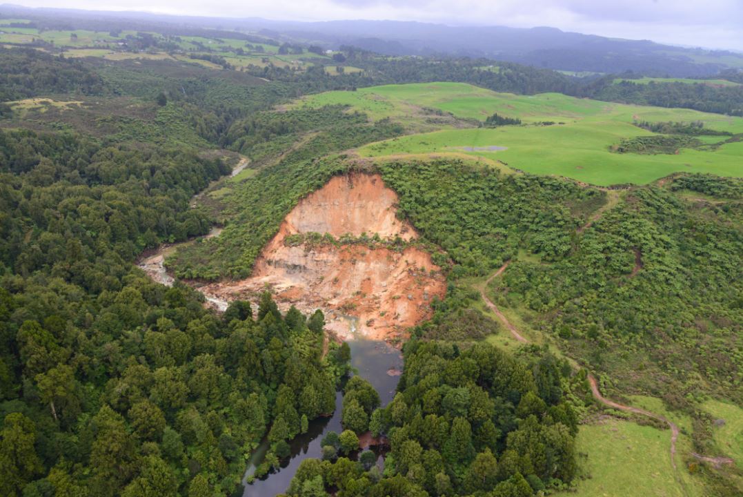
A landslide that blocked the Kaukaumoutiti Stream, northwest of Tauranga in New Zealand, triggered by the recent heavy rainfall. Image by the GNS Science landslide team, via GeoNet.
.
Once again this is a valley-blocking event. The failure appears to be rotational (note the partially displaced block). The underlying cause may have been undercutting the river – the location is on the outside of the bend, where erosion is highest. There is a beautiful 3D model of this landslide too, which even captures the flow of water over the dam.
Incredibly, the area is about to be struck by another extreme event, Cyclone Gabrielle. This is likely to bring another period of exceptional rainfall:-
https://twitter.com/MetService/status/1623805989152759809
.
It seems likely that the GNS landslide team will have another busy few days.
 Dave Petley is the Vice-Chancellor of the University of Hull in the United Kingdom. His blog provides commentary and analysis of landslide events occurring worldwide, including the landslides themselves, latest research, and conferences and meetings.