
15 March 2022
A drone video of the B4069 Lyneham landslide
A drone video of the B4069 Lyneham landslide
On 25 February I blogged about the Lyneham landslide, a substantial failure on the B4069 road at Dauntsey Banks in Wiltshire, in southern England. With thanks to Stuart Lewis, who highlighted in a comment to that original post that a video has now been posted to Youtube that provides drone footage of the landslide:-
.
The video, which was collected on 8 March 2022, provides both aerial views and static shots of this most interesting landslide. In my original post I noted that there appears to have been construction activity in the field directly upslope of the road. The video provides clarification on this. The image below is a still from the video – it is most interesting:-
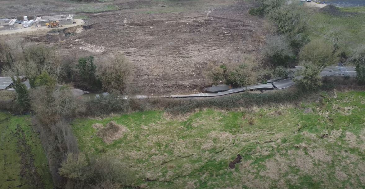
The Lyneham landslide, showing construction activity in the field upslope of the road. Still from a video posted to Youtube.
.
Here is another view of the site:-
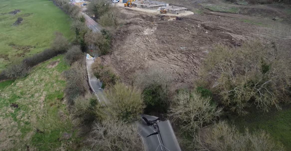
The Lyneham landslide, showing construction activity in the field upslope of the road. Still from a video posted to Youtube.
.
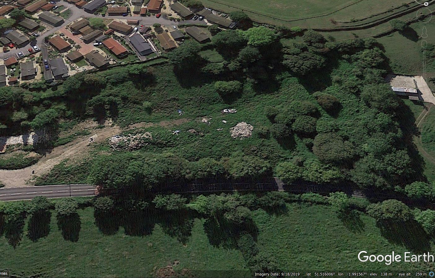
I think there are a few things to note here. First, the landslide has extended most of the way through this field, with the largest rear scarp area being located adjacent to the pad on which the new buildings are being constructed. Second, the failed section of road corresponds very closely to the eastern boundaries of the field in which construction was being undertaken. This is particularly evident in the first of the two images above. Third, it appears that although building construction has occurred in only a part of this field, it appears that the surface cover throughout has been changed. This is the field in 2019, from Google Earth:-
Google Earth image of the site of the Lyneham landslide in Wiltshire.
.
I am speculating here, but has the field been regraded (note the scarps downslope of the tracks in the second image)?
Of course, I cannot provide a link between the activities in this field and the reactivation of the landslide – that could only be established through a proper site investigation. I am sure that this is being undertaken. There are other possible causes. But it is certainly a line of enquiry that is worthy of deeper examination.
As I noted in my first post, this is an area that shows clear signs of previous landslide activity, and the failure appears to me to be a reactivation. This highlights why it is important to get input from an engineering geomorphologist before undertaking works such as this in these areas.
14 March 2022
Ampang: a deadly urban landslide in Malaysia
Ampang: a deadly urban landslide in Malaysia
On Thursday 10 March 2022 a large urban landslide occurred at Taman Bukit Permai 2 in Ampang, Malaysia, killing four people and injuring a further individual. The landslide has been extensively reported in the media in Malaysia. The two best images of the landslide that I have found are these two. The first was published in Utusan Malaysia:-
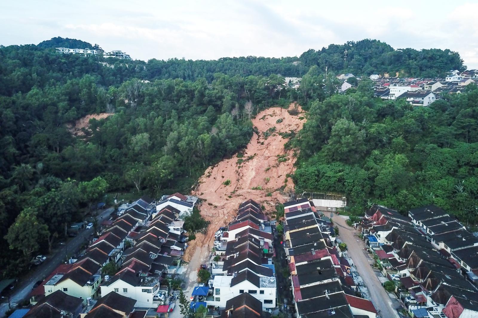
The 10 March 2022 landslide at Ampang in Malaysia. Image from Utusan Malaysia.
.
Whilst the second was published in My Metro:-
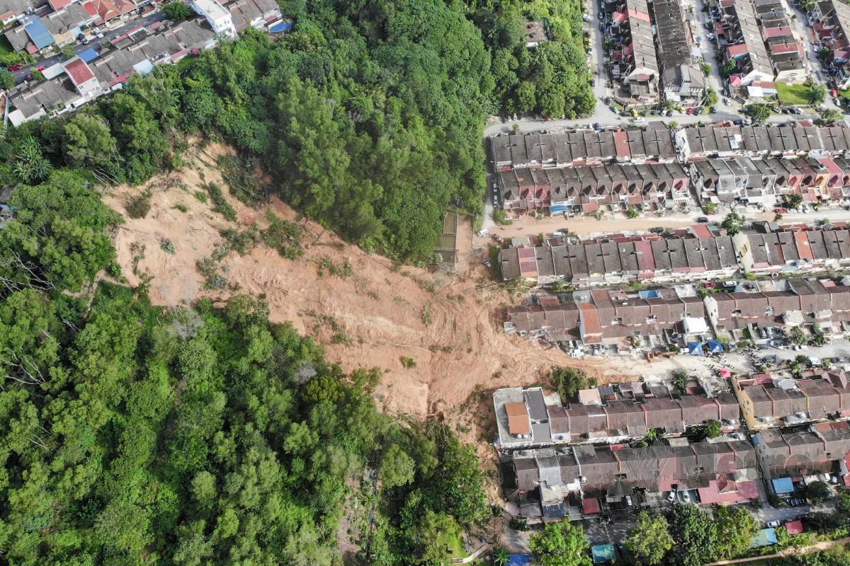
Near vertical image of the 10 March 2022 landslide at Ampang in Malaysia. Image from My Metro.
.
The landslide was triggered by heavy rainfall, which is quite unusual for this time of year in Malaysia. It appears that the immediate trigger was an extremely heavy, short duration rainfall event, although unseasonal rainfall has reportedly been falling for several weeks.
There is a video of the landslide occurring, which has been posted to Twitter:
Landslide in Ampang, 15 houses affected, three feared buried alivehttps://t.co/g1NlaKtqnN
10 March 2022
AMPANG JAYA: Some residents at Taman Bukit Permai were injured after a landslide covered several homes in Pandan Indah here today. pic.twitter.com/ABg68cpksh
— Eugene CHUNG (@eugenechung) March 10, 2022
.
The video appears to show a rotational failure in the upper part of the slope. The main track is essentially planar – it appears that the main part of the debris has moved as a flow, fortunately with only moderate mobility. The failure appears to have been in deeply weathered (residual) soil or in fill (see below). Interestingly, there are some reports that local residents had seen signs of deformation on the slope in the weeks leading up to the failure. It is also interesting to note that in the first image posted above another large landslide is visible on the slope.
The location of the landslide is 3.107, 101.762. At first glance the slope looks to be natural, but Google Earth is very revealing. The image below was collected in 2004:-
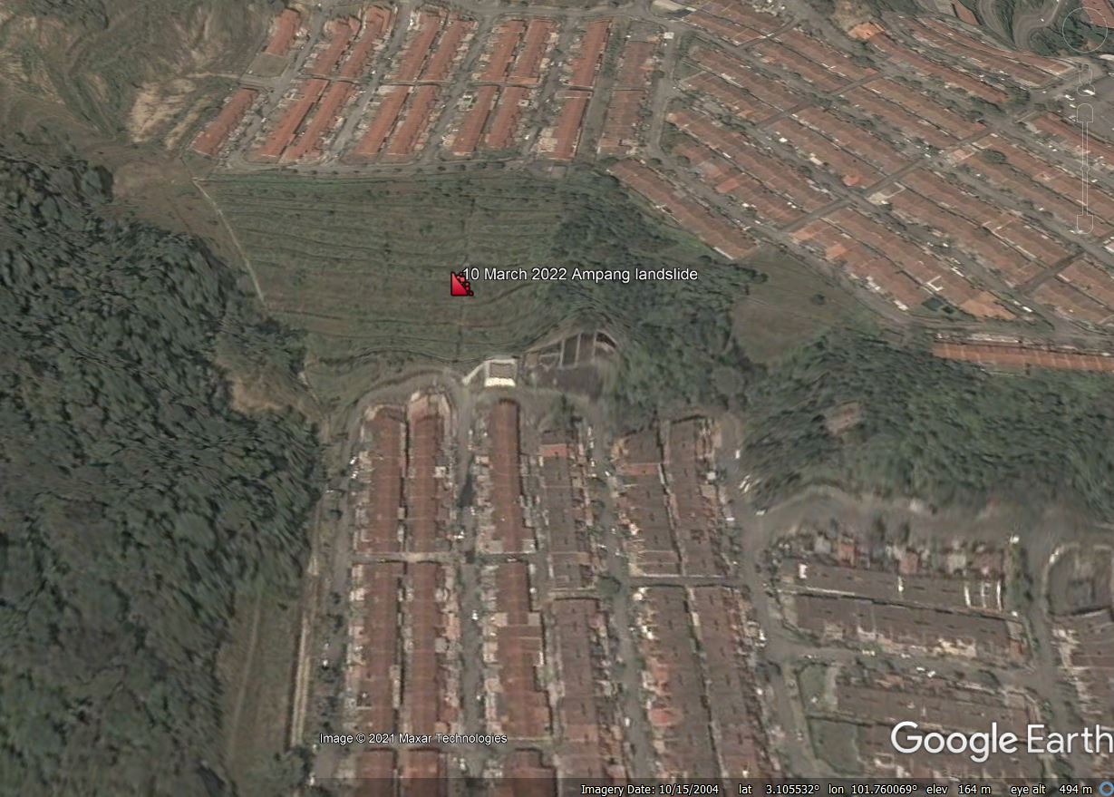
Google Earth image of the location of the Ampang landslide in Malaysia.
.
The image above appears to indicate that this was an engineered (i.e. modified) slope. It will be interesting to discover the design specification for this slope, the maintenance regime (especially with regard to drainage) and the monitoring that has been undertaken since. Hong Kong’s remarkably successful slope safety system has been based upon careful management of engineered slopes such as this.
11 March 2022
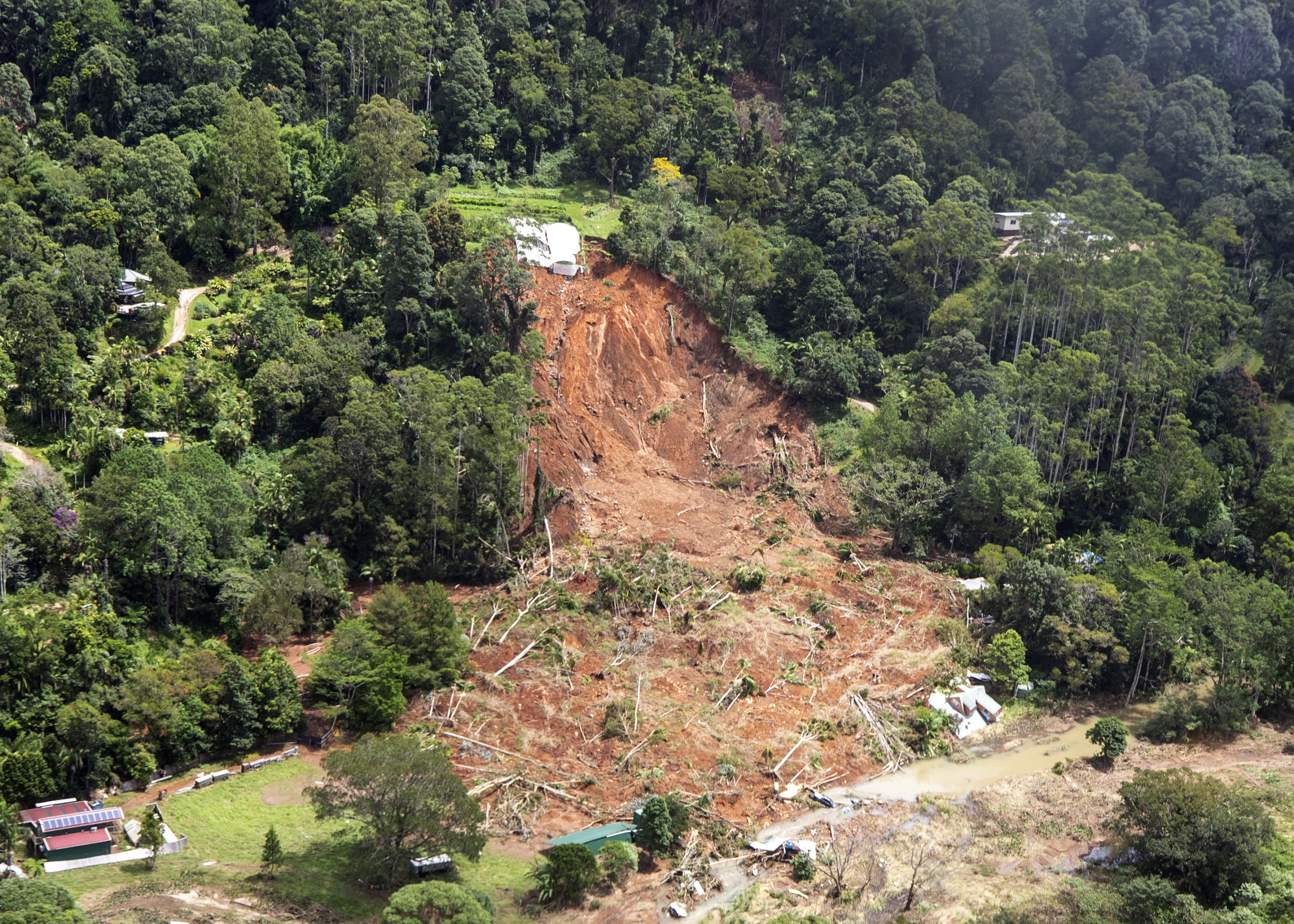
Main Arm: a significant rainfall induced landslide in Australia
Main Arm: a significant rainfall induced landslide in Australia
The eastern side of Australia has in recent days suffered a rainfall event of extreme severity, causing extensive floods and landslides, claiming at least 22 lives. It is hard to understand the magnitude of this event, and the degree to which it has varied from the long term record. The graph below, produced by the Guardian, shows the 2021-2022 cumulative rainfall to 8 March 2022 versus the long term trend for Brisbane. In this case, “very wet” is the 90th percentile:-
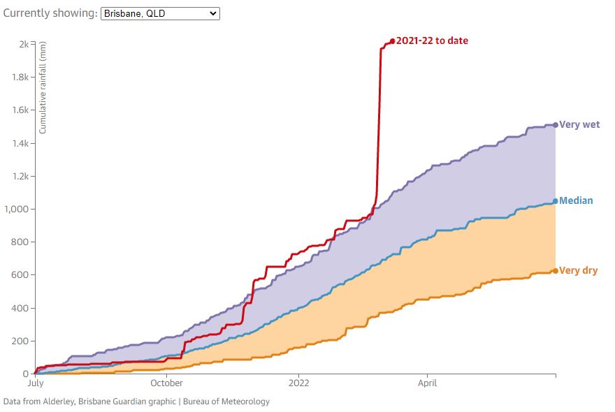
The daily cumulative rainfall for Brisbane for 2021-22 v the median, 10th percentile (very dry) and 90th percentile (very wet) of historic daily cumulative rainfall values. Historical data is from 1900 to 2021. Last updated 8 March 2021. Image from The Guardian.
.
The event of the last week or so is extraordinary, taking cumulative rainfall to double the 90th percentile value for the time of year. This is a La Nina event, turbocharged by global heating, in action.
Unsurprisingly, this rainfall had triggered landslides. An area that has been severely affected in Main Arm in the Northern Rivers region in the northern part of New South Wales. The landslide below was triggered by the rainfall (image tweeted by Liam Mendes – @liammendes):-
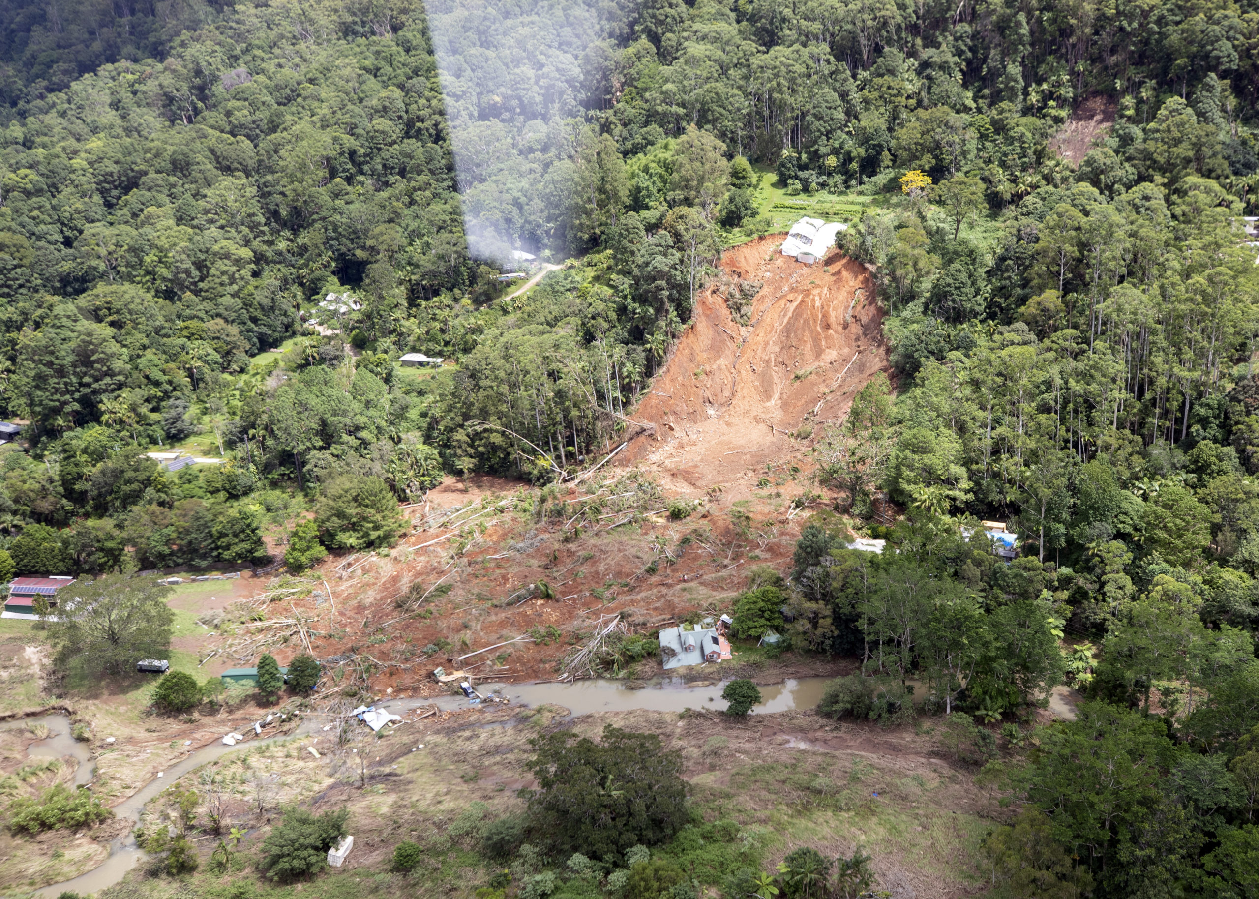
The landslide at main Arm in New South Wales, Australia. Image tweeted by Liam Mendes (@liammendes).
.
@Liammendes has also tweeted another view of the landslide:-
The landslide at main Arm in New South Wales, Australia. Image tweeted by Liam Mendes (@liammendes).
.
This landslide appears to have occurred in deeply weathered residual soil or regolith. Note the house in the lower right side of the image, which has been destroyed by the landslide.
This is only one of a number of landslides in the area. Recovery from the disaster has been severely impacted by damage to the roads caused by landslides and washouts. Fortunately there have been no reported fatalities in Main Arm.
8 March 2022
Raini: the forgotten victims of the Chamoli disaster
Raini: the forgotten victims of the Chamoli disaster
Last month saw the first anniversary of the Chamoli rockslide and debris flow disaster in northern India. Inevitably attention has moved onto to other concerns, although the damage caused by the disaster has yet to be repaired. Earlier this week, the journalist Kavita Upadhyay tweeted some images of the aftermath of the disaster:-
This is Gaura Devi's famous Raini village known for the Chipko movement. It is sinking and sliding, a glimpse of which can be seen in the photograph. The use of explosives for the Rishiganga dam had made Raini vulnerable, & after last year's disaster, it has become uninhabitable. pic.twitter.com/s4iwPXDwzf
— Kavita Upadhyay (@Upadhyay_Cavita) March 6, 2022
.
Included in the thread was the image above the village of Raini, which continues to suffer serious landslide issues in the aftermath of the debris flow. As Kavita notes, Raini was suffering substantial problems even before the disaster, possibly linked to environmental damage caused by the construction works for the hydroelectric scheme. The debris flow has most likely eroded the toe of the slope, triggering largescale movement that is now impacting most of the village.
The Google Earth image below was collected in the immediate aftermath of the Chamoli disaster. It shows Raini perched on the slopes above the river. The slope looks highly unstable:-
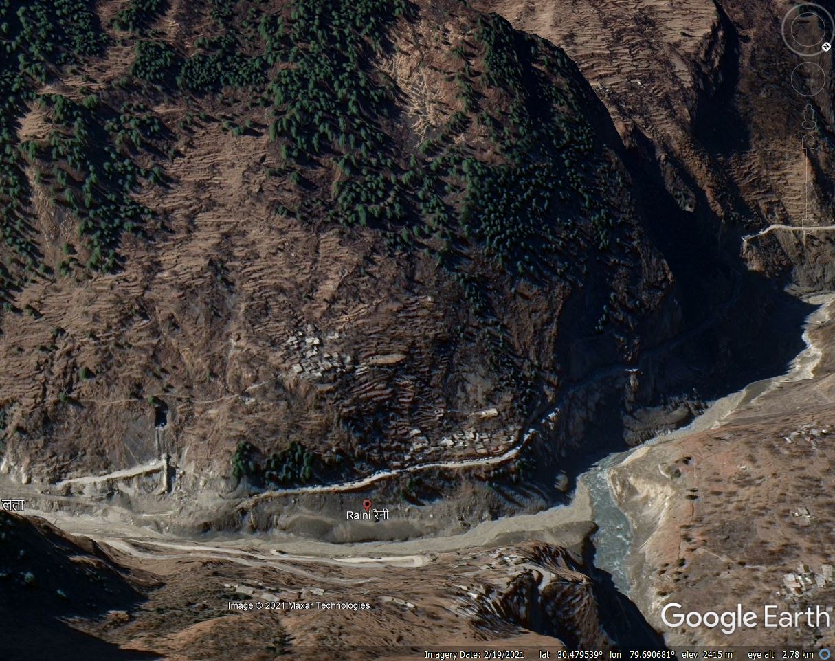
Google Earth image of the village of Raini in northern India in the immediate aftermath of the Chamoli disaster.
.
Back in the summer, the Hindustan Times highlighted the ongoing concerns about Raini. It quotes a report compiled by geologists working for the Uttarakhand Disaster Recovery Initiative (UDRI):-
“The Raini village is facing serious slope stability problems where the whole area is affected by active subsidence whereas downslope is affected by toe erosion. During investigation wide cracks were observed in the walls and floors of many houses indicating active slope movement in the area. It is therefore advisable to rehabilitate Raini village to an alternative safe location.”
Relocation of the village is inevitably the preferred option, but this is being resisted by the inhabitants of the village. This is understandable – relocation is a deeply traumatic experience that often leads to very adverse outcomes for those affected.
As we head towards the 2022 monsoon, the situation for Raini is likely to become acute once again. For the population, the legacy of the Chamoli disaster is permanent dislocation.
25 February 2022
Lyneham – an interesting landslide from the south of England
Lyneham – an interesting landslide from the south of England
Yesterday the BBC reported on another serious landslide triggered by the heavy rainfall that fell across the UK last week. This landslide has caused very significant damage to the B6049 road near to the village of Lyneham in Wiltshire. The location is 51.517, -1.991. The BBC has this image of the aftermath of the landslide:-
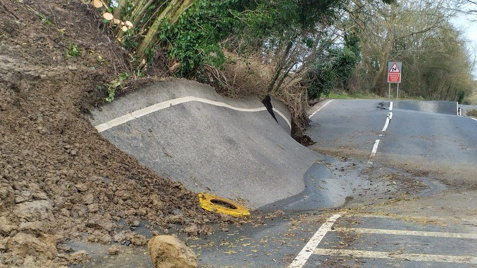
Landslide damage to the B4069 in Lyneham, Wiltshire. Image from the BBC.
.
It is clear that there has been very substantial vertical movement on the slope. Interestingly, a Google StreetView image of the road suggests that it was undergoing considerable distress back in October 2021:-
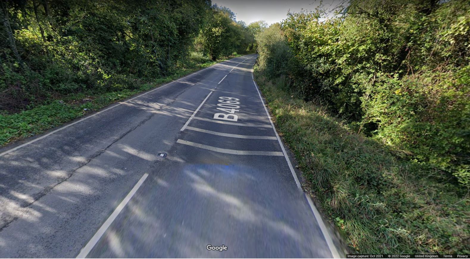
Google StreetView of a section of the B6049 near to Lyneham, showing extensive cracking in the road.
.
This crack appears to indicate extension, which is consistent with the deformation observed in the failure last week.
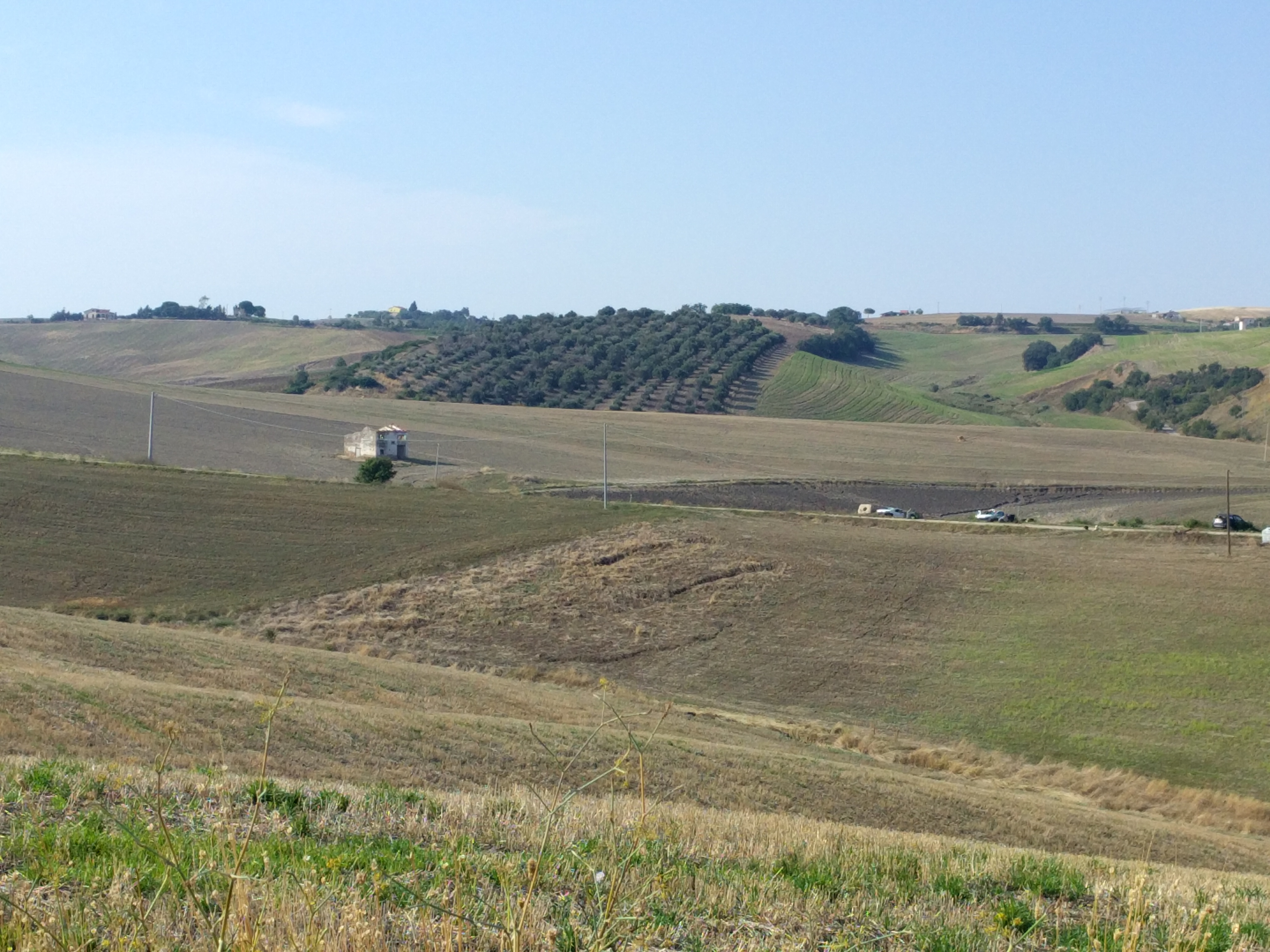
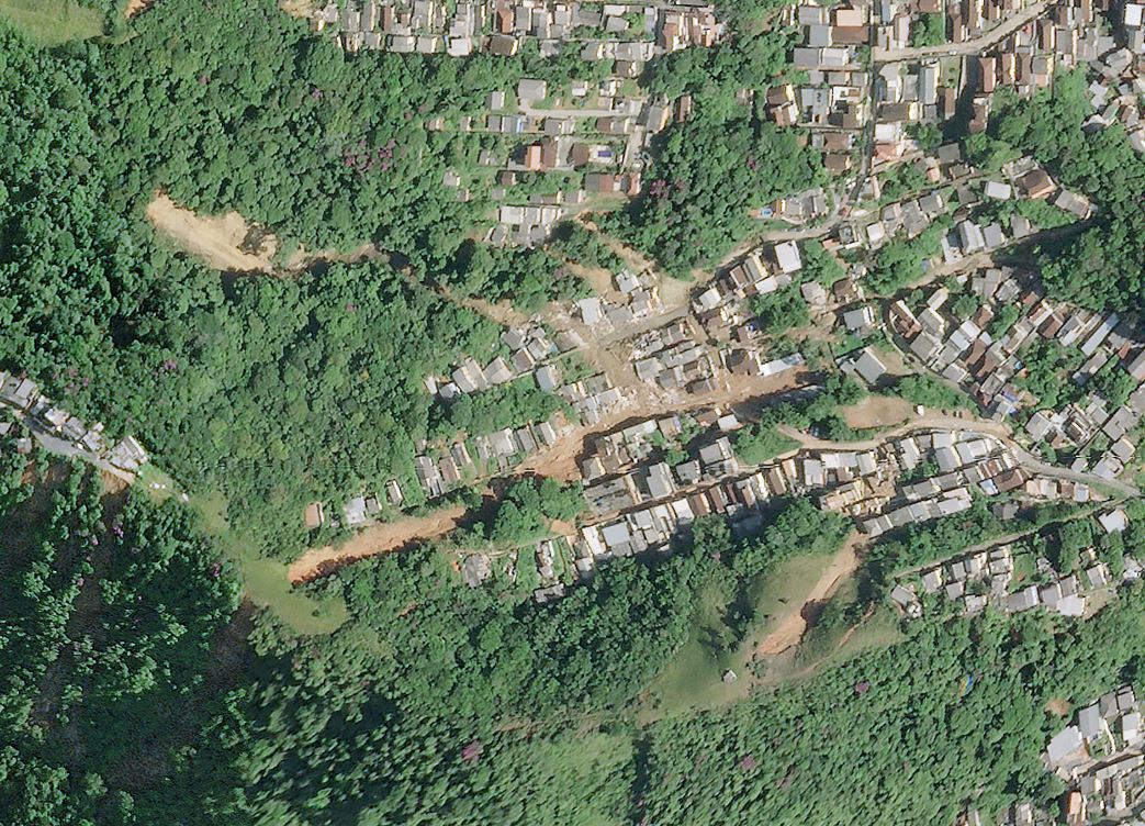
Google Earth has good imagery of the site. This image was collected in April 2021:-
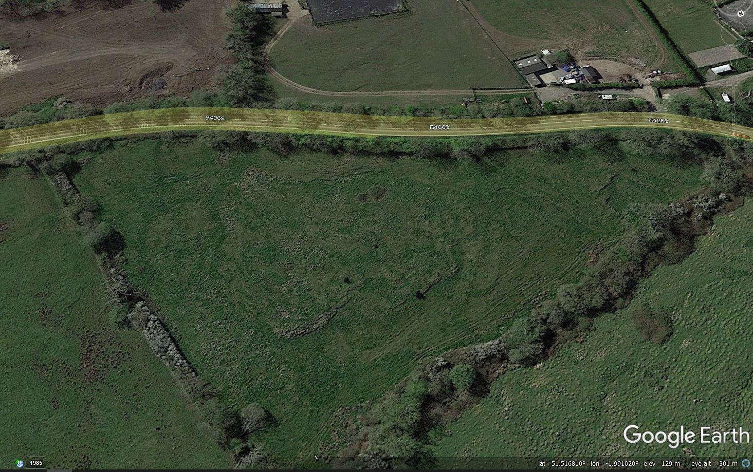
Google Earth image of the site of the landslide at Lyneham in southern England. Note the relict solifluction feature in the field downslope of the road.
.
In the field downslope of the road (nearer to the camera) there is a clear large, shallow landslide lobe. There is a further lobe to the right of the image, emerging from the same morphological feature. I would interpret this as probable ancient solifluction landslide – an active layer detachment – left over from the period when this area was affected by permafrost conditions during Pleistocene “Ice Age”. These features are common in southern Britain. Note also that upslope of the road there appear to be some features that could be tension cracks in the field.
There are similar lobes in some of the other fields too.
So the most likely explanation for the landslide near to Lyneham is that it is a reactivation of a pre-existing failure, probably a solifluction landslide, caused by the exceptional rainfall that we are now experiencing. Of course a detailed site investigation is needed to verify this initial hypothesis.
It will also be interesting to find out whether this is simply the results of increased rainfall or whether some other change has occurred in the area, such as a modification to the drainage. Are there signs of some construction activity in the field in the top left corner, for example? Without a detailed investigation it is impossible to know if this could have been a factor.
24 February 2022
The A57 Snake Pass – closed by three landslides
The A57 Snake Pass – closed by three landslides
The major road between my home town of Sheffield and the major city of Manchester – two of the largest cities in the north of England – is the A57 Snake Pass. This road, shown on the Google Earth image below, passes through the heart of the Peak District National Park. The road is single lane in each direction, sinuous and challenging (but fun) to drive.
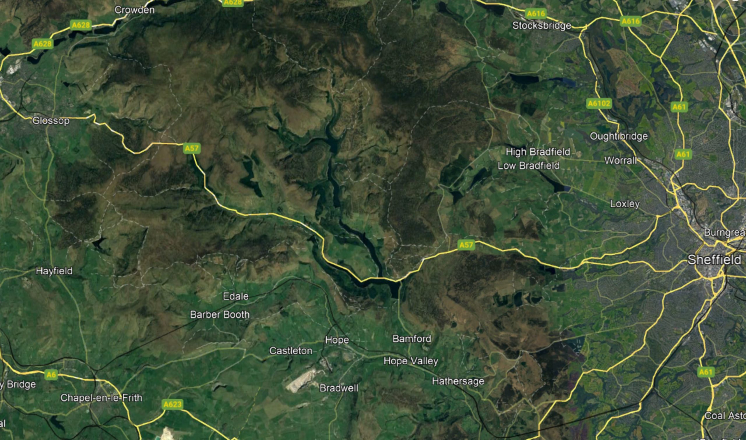
Google Earth map of the A57 Snake Pass in northern England.
.
By global standards the terrain is not high or steep, but the Peak District is subject to quite challenging winter weather, such that the road is closed for an average of 70 days per year.
An interesting aspect of the road is that it crosses a number of landslide complexes. I have written previously about landslides in the Peak District. Over the last weekend three names storms brought very heavy rainfall to this area. As a result three landslides have reactivated – two are previous sites of movement, but the third appears to be new but substantial – the road has reportedly dropped by two metres. Movement is reported to be continuing. The road has been closed, and reports suggest that repairs will take at least a month.
The image below illustrates the scale of the problems that face those responsible for the road. This previously glaciated area has a very complex geomorphology:-
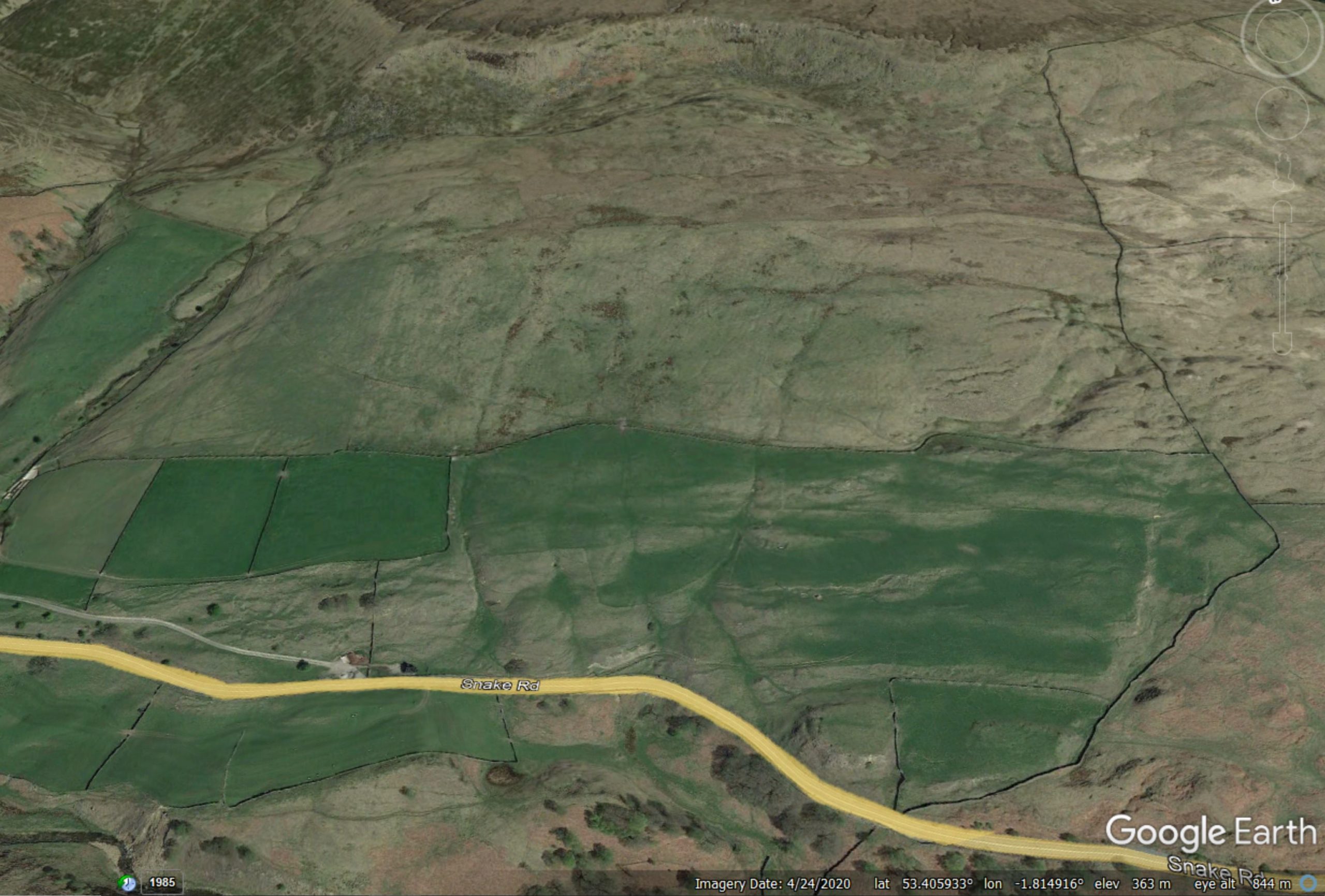
Google Earth image showing a section of the terrain in the vicinity of the A57 Snake Pass in northern England.
.
As an engineering geologist with an interest in landslides, the above image gives lots of reasons to pause for thought. The large arcuate scarp at the top of the slope is of interest for example, as are the areas of hummocky terrain across the slope. Near to the Snake Pass there are areas that look like they might have been unstable.
This pattern is replicated in numerous locations. The manifestation for the highway is a number of sections in which active movement is clearly visible. This Google Street Map image shows such a section:
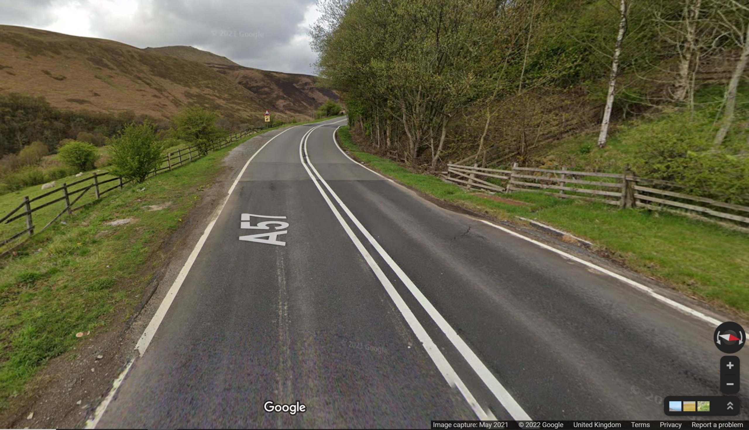
Google Street Map image of a landslide damaged section of the A57 Snake Pass.
.
Most of these landslides are ancient, pre-dating the road by centuries. However, climate change has meant that rainfall intensities are increasing, especially in the series of low pressure systems that frequently occur. It is these rainfall events that are causing the problems.
Unfortunately, this situation is likely to get worse in the coming decades. Upgrading the road is difficult in a national park. Unfortunately, users of the Snake Pass are likely to face many more road closures in the years to come.
22 February 2022
Increased landslide activity after low-magnitude earthquakes
Increased landslide activity after low-magnitude earthquakes
Over the last 25 years there has been increasing awareness and understanding of landslides triggered by high-magnitude earthquakes. Key events in generating our understanding have included the 1989 Loma Prieta earthquake in California, the 1999 ChiChi earthquake in Taiwan and the 2008 Wenchuan earthquake in China, amongst many others. There has also been an increased awareness of the elevated occurrence of landslides in earthquake affected areas for years or even decades after the main shock.
This understanding has raised the intriguing question as to whether low-magnitude events also have an impact on landslide occurrence in the years following the main shock, and if so, how large is the impact? This is a difficult issue to unpick as the effects are likely to be comparatively small, and will occur over a much more limited area.
A paper just published in Nature Scientific Reports (Martino et al. 2022) explores this issue in relation to the 16 August 2018 Mw=5.1 earthquake in the Molise area of central Italy. This earthquake triggered 84 landslides, primarily consisting of the movement of soil materials on comparatively low angled slopes. I posted about this earthquake at the time, including this image of a landslide triggered by the event:
Slope failures triggered by the 16 August Molise earthquake in Italy. Image from Salvatore Martino, University of Roma “Sapienza”.
.
The authors have used differential InSAR analysis to examine the movement of these slopes for the two years prior to the Molise earthquake and in the year after. Landslides in this area are primarily triggered by rainfall, which has a seasonal distribution. Thus, most slope movements occur in the autumn and winter. Over the three years of the study the seasonal rainfall totals were comparable, but in the post-earthquake year there was an increases of 118% in the number of reactivations of the landslides detected using the InSAR technique. The main effect was seen in the first three months after the mainshock. Thereafter it declined over a period of about three months, and by the spring the effect had disappeared.
The authors specifically exclude the possibility that this increase in landslide activity was related to increased rainfall after the earthquake – indeed the autumn and winter was slightly less wet than in the previous two years.
The mechanical cause of this increase in landslide activity is not clear to me. There is a range of possibilities, including weakening of the materials, with strength being regained over time; the retention of localised high pore water pressures in the slope after the earthquake, which then reduce; the effects of aftershocks that of course decline with time; temporary changes in the drainage of the slopes; or the opening of fractures that allow rainfall to infiltrate, but which then clog up.
More research is needed into this effect, both in times of the degree to which it occurs elsewhere and the causes of it. But it is a really interesting result that is important both for our understanding of hazard and the evolution of landscapes.
.
Reference
Martino, S., Fiorucci, M., Marmoni, G.M. et al. 2022. Increase in landslide activity after a low-magnitude earthquake as inferred from DInSAR interferometry. Scientific Reports 12, 2686. https://doi.org/10.1038/s41598-022-06508-w
21 February 2022
Landslide risk in the Brazilian city of Petrópolis
Landslide risk in the Brazilian city of Petrópolis
The recovery operations in the aftermath of the dreadful landslides in Petrópolis, Brazil continue. To date there are over 150- confirmed fatalities, with many more reported to be missing. There is no prospect of finding any further survivors.
Inevitably attention is now returning to the causes of the disaster. ABC News has an excellent article exploring the issues. The piece uses an excellent quote from Antônio Guerra, who is a professor of geography professor at the Federal University of Rio de Janeiro, and who has studied weather-related catastrophes in Petropolis for almost 30 years. He says:
“Rain is the great villain, but the main cause is poor land use. There’s a total lack of planning,”
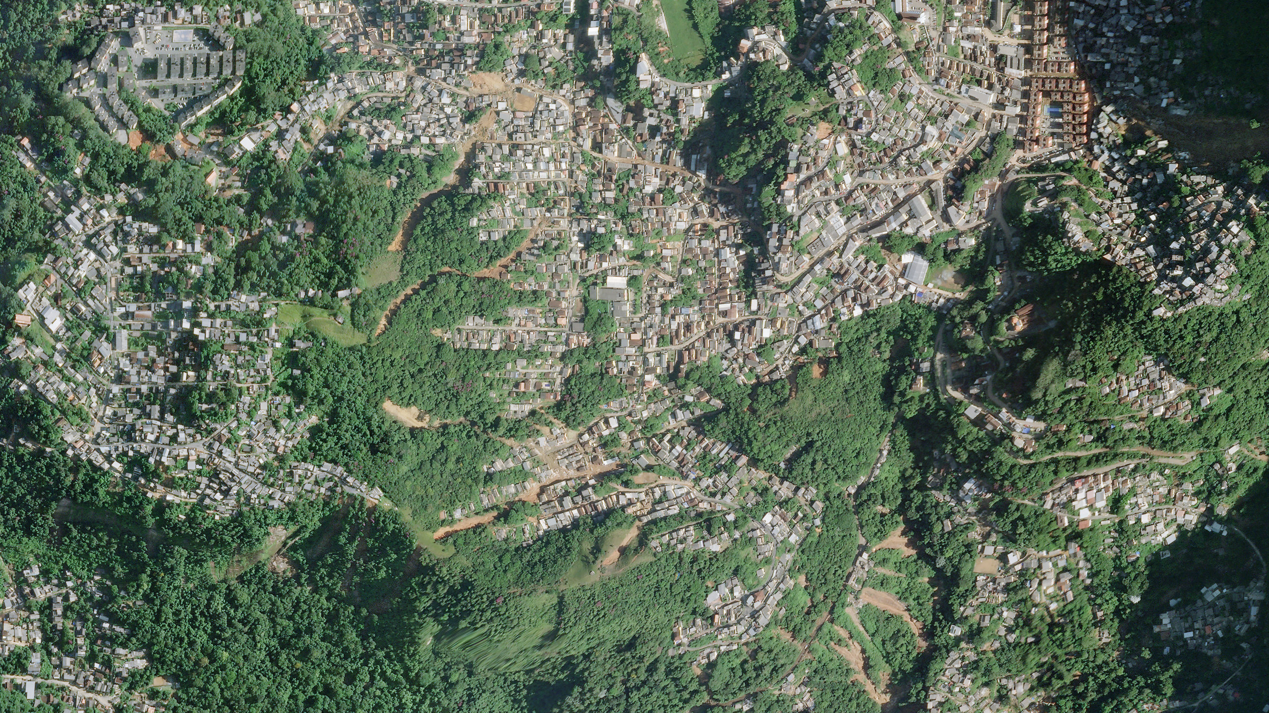
This is exactly right. The Google Earth image of Petrópolis below shows a sprawling city built between and on steep slopes, with little or no planning and few attempts to make the slopes safe:-
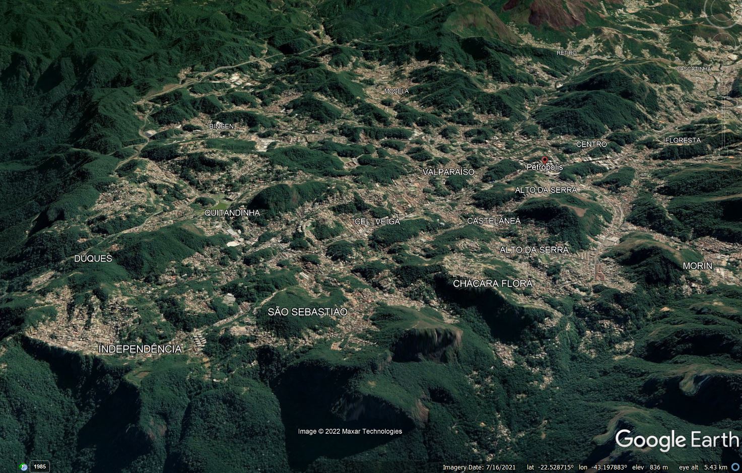
Google Earth image of the city of Petrópolis in Brazil.
.
The city has over 300,000 inhabitants, many of whom live in poorly planned housing on steep slopes. The ABC article notes that in 2017 about 20,000 households – 18% of the total – were located on slopes with high or very high risk. Climate change is of course elevating that risk, primarily because of increasing rainfall intensities.
That Petrópolis has high levels of landslide risk is not news. Almost 30 years ago Antônio Guerra published an article (Guerra 1995), available online, reviewing catastrophic events in the city between 1940 and 1990. The abstract of the article notes that:
“Petrópolis has suffered 1,161 catastrophic events (1940-1990 only) including landslides, mudslides, rockfalls and floods. Most events are caused by heavy rains…The number of deaths appears to be increasing and nearly 90% of the events occurred within urbanized areas. Currently the principal responses are reactive, rather than preventive.”
The management of landslide risk in cities in expensive and difficult, but Hong Kong has demonstrated that it is possible. Petrópolis will continue to suffer disasters, probably at an accelerating rate, unless action is taken.
.
Reference
Guerra, A. 1995. Catastrophic Events in Petrópolis City (Rio de Janeiro State), between 1940 and 1990. GeoJournal, 37 (3), 6 pp.
18 February 2022
Planet satellite image of the urban landslides in the Alto da Serra area of Petrópolis, Brazil
Planet satellite image of the urban landslides in the Alto da Serra area of Petrópolis, Brazil
Planet have very kindly captured a new high resolution satellite image of the 15 February 2022 landslides in Petrópolis in Brazil. These are 50 cm resolution images, providing very high level of detail. The first of the two images was taken in the area of Alto da Serra – the centre of the image is at about -21.516, -43.169:-
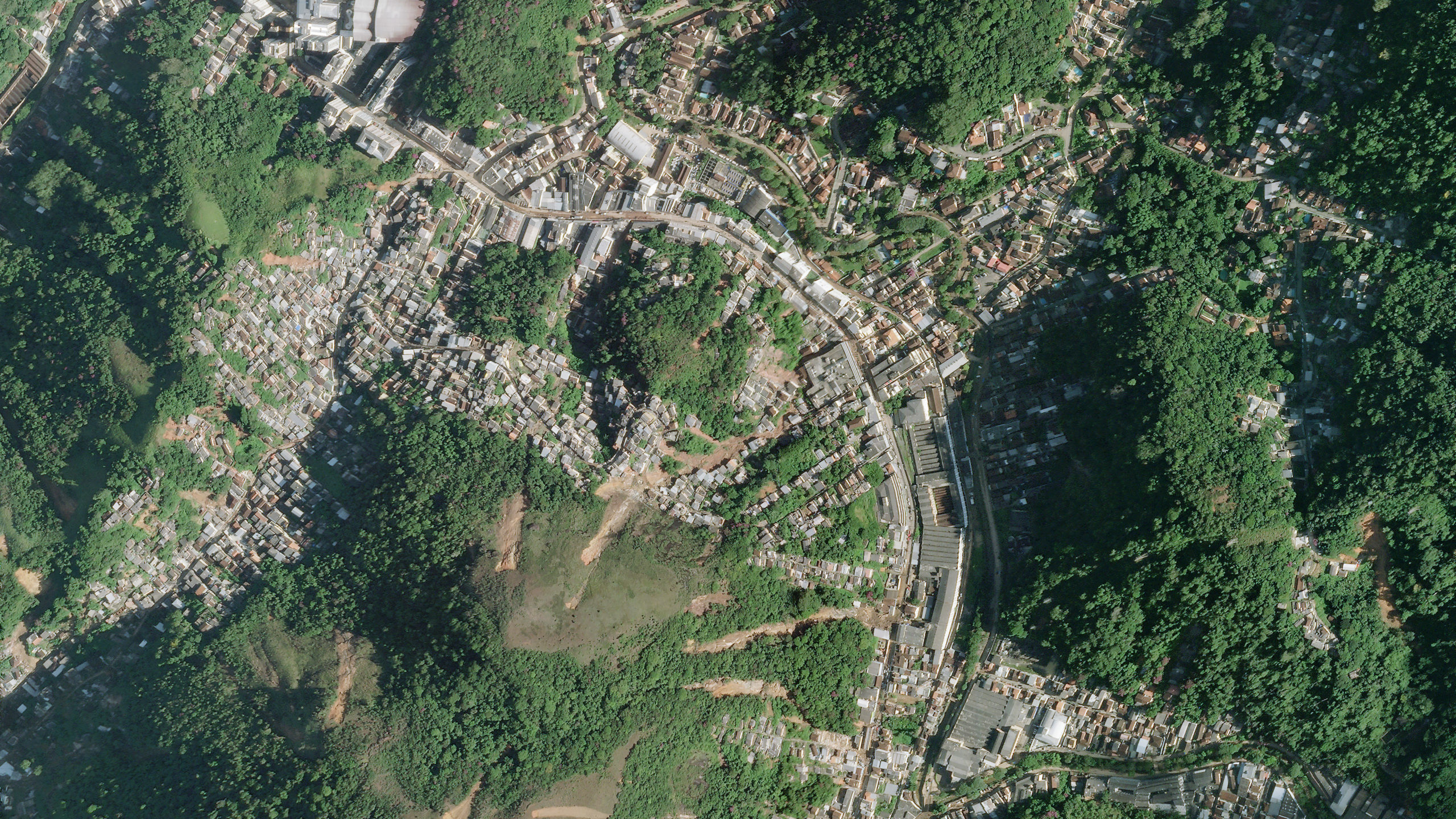
High resolution satellite image of the landslides in the Alto da Serra area of the city of Petrópolis in Brazil. Image copyright Planet, used with permission.
.
In the centre of the image are multiple shallow landslides, starting on the hillsides but descending into the inhabited areas. There are also several landslides on the western side of the image. The landslides in the centre of the image are worth examining in more detail:-
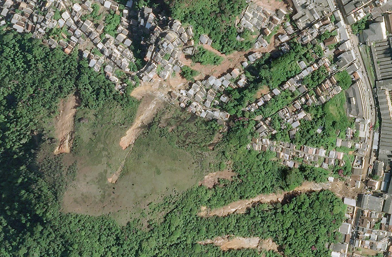
High resolution satellite image of the urban landslides in the Alto da Serra area of the city of Petrópolis in Brazil. Image copyright Planet, used with permission.
.
In most cases these are smallish, shallow slips that have entrained debris along the track to form channelised flows. The long landslide in the lower eastern corner is interesting – it appears to have damaged buildings and to have deposited debris on the road.
Planet has also captured an image to the south of the above image, close to Morro da Oficina:-
High resolution satellite image of the landslides in the Alto da Serra area of the city of Petrópolis in Brazil. Image copyright Planet, used with permission.
.
The lower portion of the large landslide at Morro da Oficina is just visible in the northeast corner of the image. But note the multiple landslides in the centre of the image and towards the upper part. Again, these slides have started in unpopulated areas but the debris has flowed into the inhabited regions. As the image below shows, there is evidence of serious structural damage in places:-
High resolution satellite image of damage caused by the landslides in the Alto da Serra area of Petrópolis, Brazi. Image copyright Planet, used with permission.
.
These multiple landslides are extremely hazardous for the local population and are difficult to manage in an emergency situation.
The latest news from the city makes grim reading. There are now 117 confirmed deaths, with a further 140 reported to be missing. Some reports indicate that the number missing may be as high as 700 people, although it is not unusual for the number missing to be far too high at this stage of an emergency. It is not clear how many of these died in the landslide at Morro da Oficina, but the toll there is undoubtedly substantial given that 80 houses were destroyed. So far, 269 landslides have been identified, and a further 56 “landslides and falls of trees” have been recorded.
.
Acknowledgement
Planet Team (2022). Planet Application Program Interface: In Space for Life on Earth. San Francisco, CA. https://www.planet.com/. Thanks in particular to Robert Simmon for his help in acquiring and preparing these images.
17 February 2022
The very large urban landslide at Morro da Oficina in Petrópolis
The very large urban landslide at Morro da Oficina in Petrópolis
Information is slowly emerging about the magnitude of losses from the landslides and flood resulting from the exceptional rainfall event in Petrópolis on Tuesday. The confirmed death toll is now 104 people, with a further 35 people reported as missing.
The comparative role of landslides versus floods is not clear at this point. There is some extremely harrowing footage of people trying to escape from buses that were being overwhelmed by flooding. But reports indicate that there were at least 170 landslides, and there is no doubt that these will have caused substantial loss of life.
The largest landslide appears to have occurred at Morro da Oficina, where an extremely large urban failure occurred. It is estimated that 80 houses were inundated. Sky News has a good image of the upper portion of this landslide:-
The upper portion of the landslide at Morro da Oficina in Petropolis. Image via Sky News.
.
The upper portion of this landslide appears to be a large slide on the interface between bedrock and regolith. In the mid portion it is a slide in regolith, with large amounts of entrainment. The image below, from CNN, shows the lower portion of the landslide, where it has crashed through the houses. The level of destruction is extreme, and large numbers of fatalities seem very likely:-
The lower portion of the landslide at Morro da Oficina in Petrópolis. Image via CNN.
.
Some of videos debris flows passing through the streets, for example of Rua dos Ferroviarios, may well be associated with this type of landslide – note how the debris at the bottom of the image above has followed the line of the roads. Globo has some nice infographics showing the distribution of the impacts.
The Google Earth image below shows the site of the landslide at Morro da Oficina. The steepness of the topography is notable:-
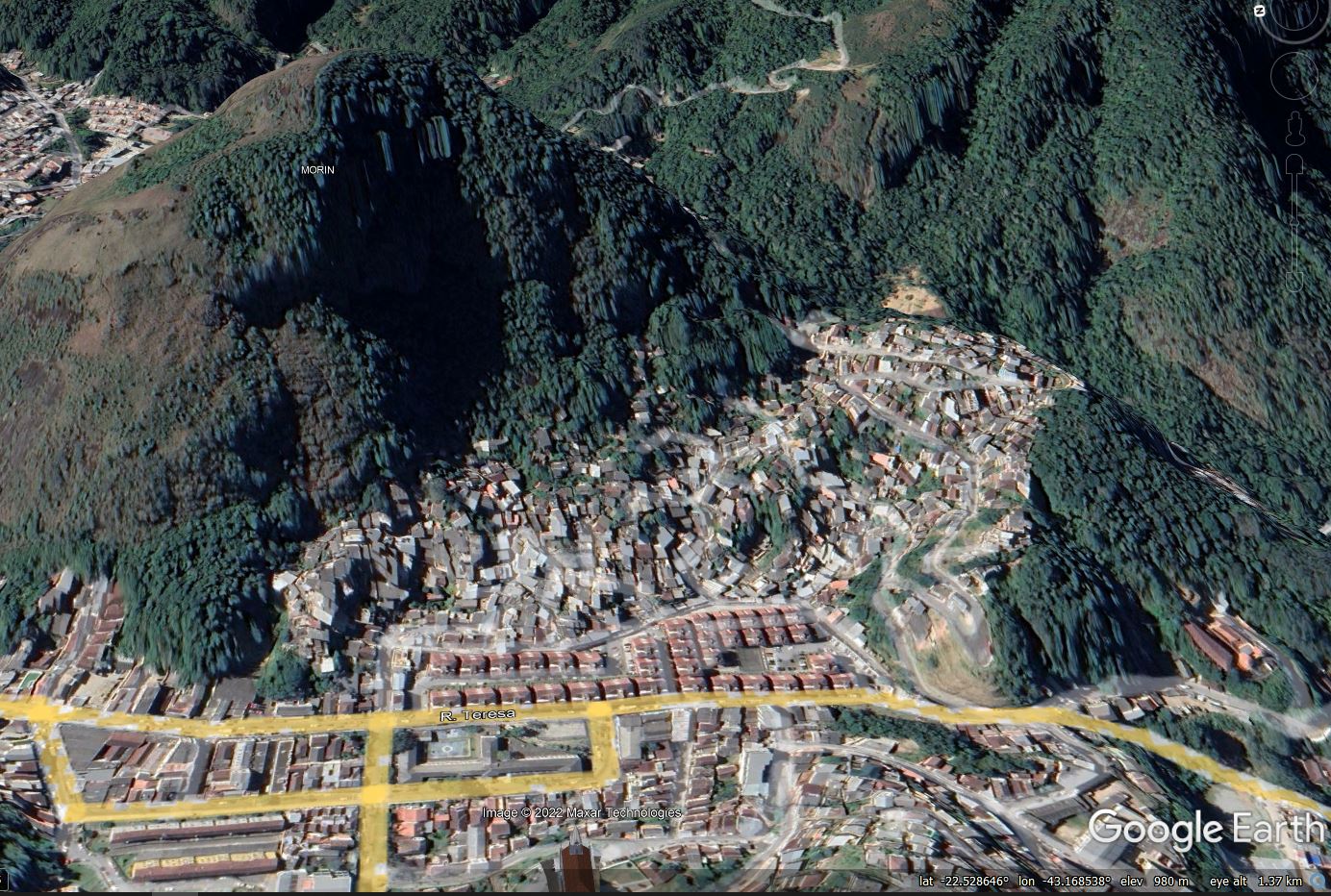
Google Earth image of the site of the landslide at Morro da Oficina in Petrópolis.
.
The location is -22.529, -43.170. O Globo has an article that includes a dynamic map of the main events, including the locations of nine major landslides.
 Dave Petley is the Vice-Chancellor of the University of Hull in the United Kingdom. His blog provides commentary and analysis of landslide events occurring worldwide, including the landslides themselves, latest research, and conferences and meetings.
Recent Comments