
16 February 2022
Petrópolis: heavy rainfall causes landslides and floods
Petrópolis: heavy rainfall causes landslides and floods
Extremely heavy rainfall in the town of Petrópolis in Brazil triggered landslides and floods yesterday. At the time of writing, the death toll had risen to 23 people, but this may change in the coming hours.
There are at least 49 reported landslides across the region. At least one significant, fatal landslide occurred in Morro de Oficina, with at least six fatalities reported.
There are some dramatic videos of the events. This one shows a very rapid debris flow cutting through the city:-
.
Whilst the one below shows an extraordinarily destructive landslide destroying houses:-
.
Globo news reports indicate that Petrópolis received extraordinary levels of rainfall:-
“The highest hourly record is 125.8 mm/h at 5:15 pm in the Alto da Serra (INEA) rain gauge. In São Sebastião, the accumulated rainfall in 6 hours reached 259.8 mm at 9:10 pm”
Rainfall intensities of over 100 mm per hour are rare worldwide, and nearly always cause huge problems.
There are few reliable photographs at this stage – these are likely to emerge later today. However, the image below has been widely tweeted, with indications that it was taken at Morro de Oficina. It would appear to indicate a large, highly destructive event:-
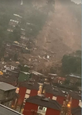
Image reportedly showing the aftermath of a landslide at Morro da Oficina in Petrópolis. Image widely tweeted.
15 February 2022
Multiple landslides at East Cape in Gisborne District, New Zealand
Multiple landslides at East Cape in Gisborne District, New Zealand
Yesterday I wrote about heavy rainfall in the early part of this month, caused by the passage of Cyclone Dovi, and the landslides in the Southern Alps that resulted. Dr Murry Cave, the Principal Scientist at Gisborne District Council, has very kindly highlighted another set of events, this time in the East Cape area of Gisborne District. The Gisborne Herald has a good article about the landslides, which have cut off five houses in an area that is sparsely populated.
Murry has provided some excellent images and information about this event.
First, this is the hourly rainfall record for East Cape, which indicates a peak hourly intensity of 45 mm and a total storm rainfall of about 300 mm:-
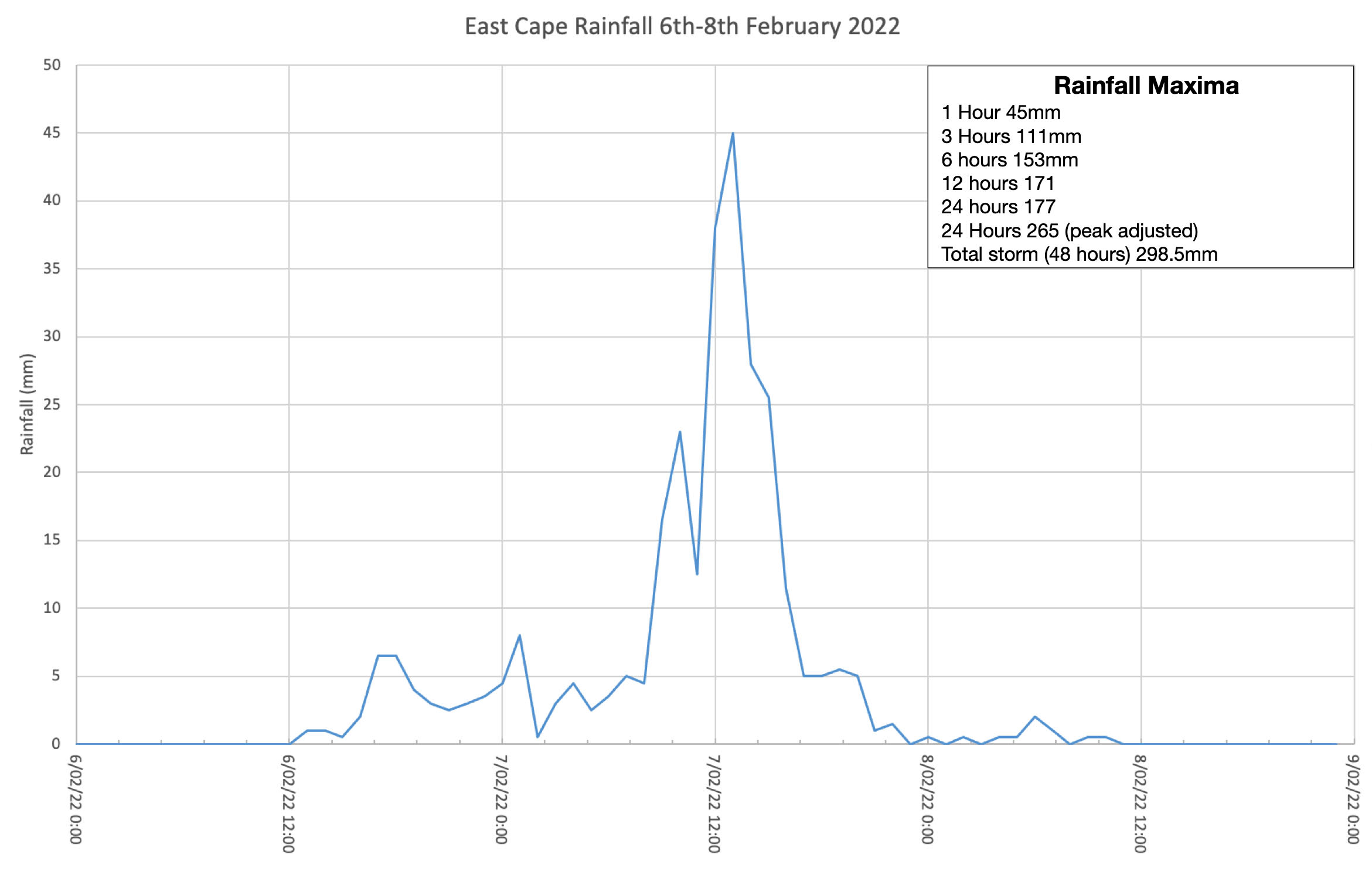
The hourly rainfall record for East Cape. Image provided by Dr Murry Cave..
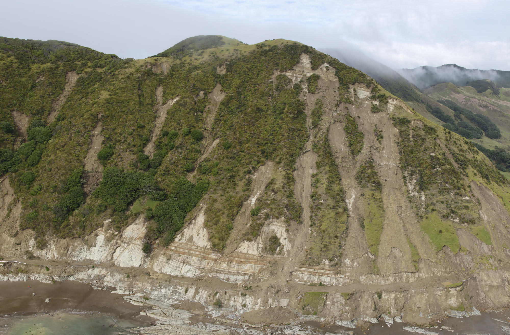
The following three images show the landslides triggered by the rainfall in the East cape area:-
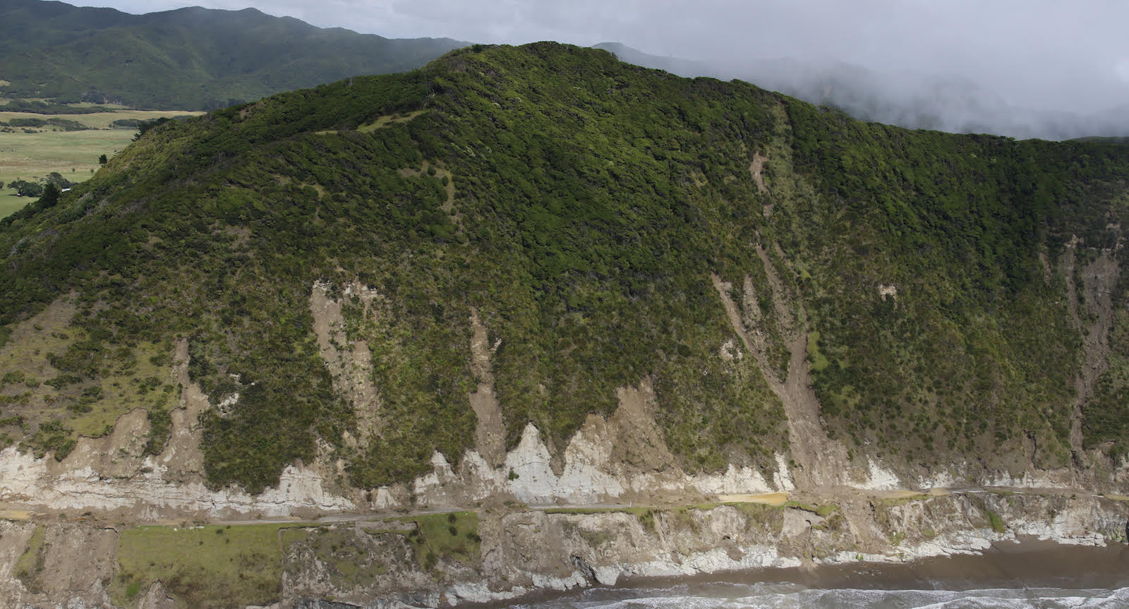
Landslides triggered by heavy rainfall from 6 to 8 February 2022. Image courtesy of Dr Murry Cave.
.
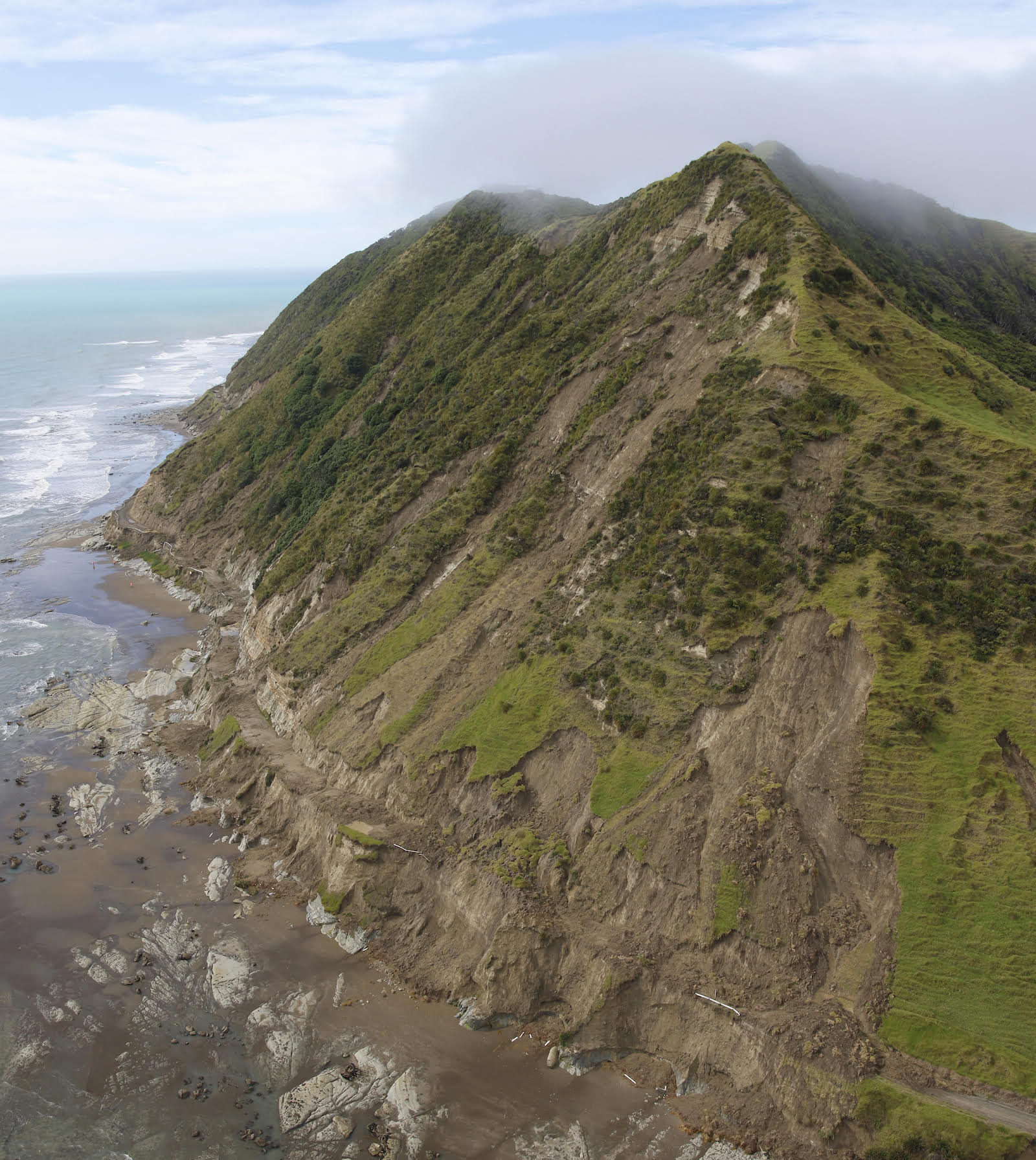
Landslides triggered by heavy rainfall from 6 to 8 February 2022. Image courtesy of Dr Murry Cave.
.
Landslides triggered by heavy rainfall from 6 to 8 February 2022. Image courtesy of Dr Murry Cave.
.
These landslides would probably be characterised as disrupted slides of earth, rock and debris. Most appear to originate in the soil / regolith cover on these very steep slopes. On the lower slopes the width of the failures is much higher. Note that the hills in the background have not suffered landslides to this degree, suggesting that this was driven by a highly localised rainfall event and/or by a local geological factor.
Geonet is asking New Zealanders to help them to identify other landslides triggered by Cyclone Dovi.
I have previously posted about another set of landslides in the Beach Loop area to the south of Whareongaonga, about 30 km from Gisborne. Brenda Rosser at GNS Science has led work investigating these landslides – there is a fantastic 3D model of the failures on the sketchfab website, resulting from mapping via a drone.
14 February 2022
Two new large landslides in the Southern Alps of New Zealand
Two new large landslides in the Southern Alps of New Zealand
In recent weeks the Southern Alps of New Zealand have suffered substantial rainfall events, including 1,177 mm of precipitation in three days at Tuke Hut in Westland. In consequence two large landslides have occurred. Loyal reader and friend Simon Cox at GNS Science has kindly provided details, with additional information having been posted at the excellent Matariki Project website, which is jointly managed by Simon, Pascal Sirguey and Aubrey Miller, both of the University of Otago School of Surveying.
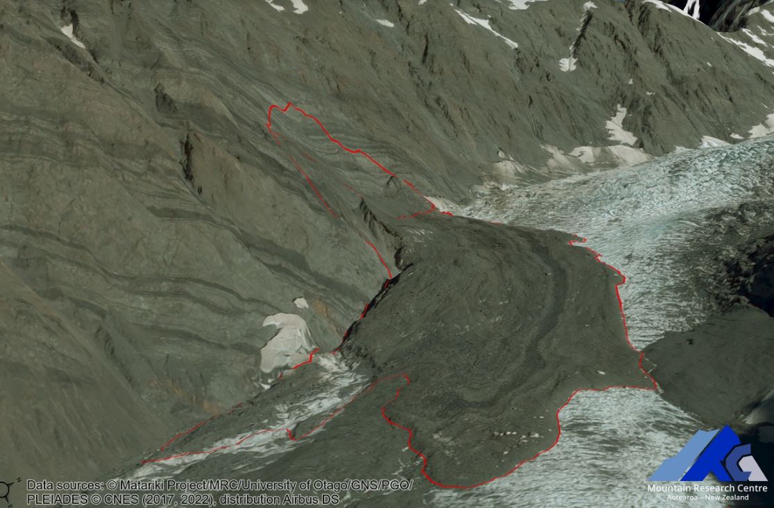
One of these events occurred on east face of Mount Tasman, which is the second highest peak in New Zealand. DOC Aoraki Mountain Rescue posted a helicopter video of the landslide to Facebook – it’s pretty good – giving a decent oversight of the event. The image below, generated by the Matariki Project team, shows the landslide:-
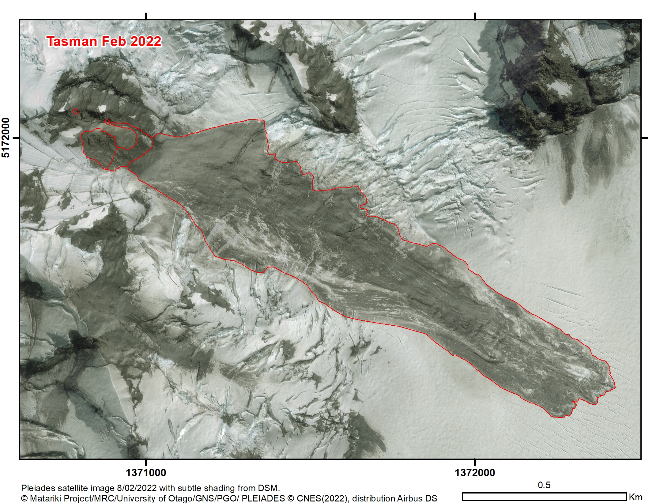
The February 2022 landslide on Mount Tasman in New Zealand. Image copyright of the Matariki Project, used with permission. Satellite image by PLEIADES, distribution Airbus DS.
.
This landslide has a rock volume of about 169,000 cubic metres, with a runout distance of 1,800 m and a fall height of 750 m.
The image below provide a rather beautiful 3D view of the landslide:
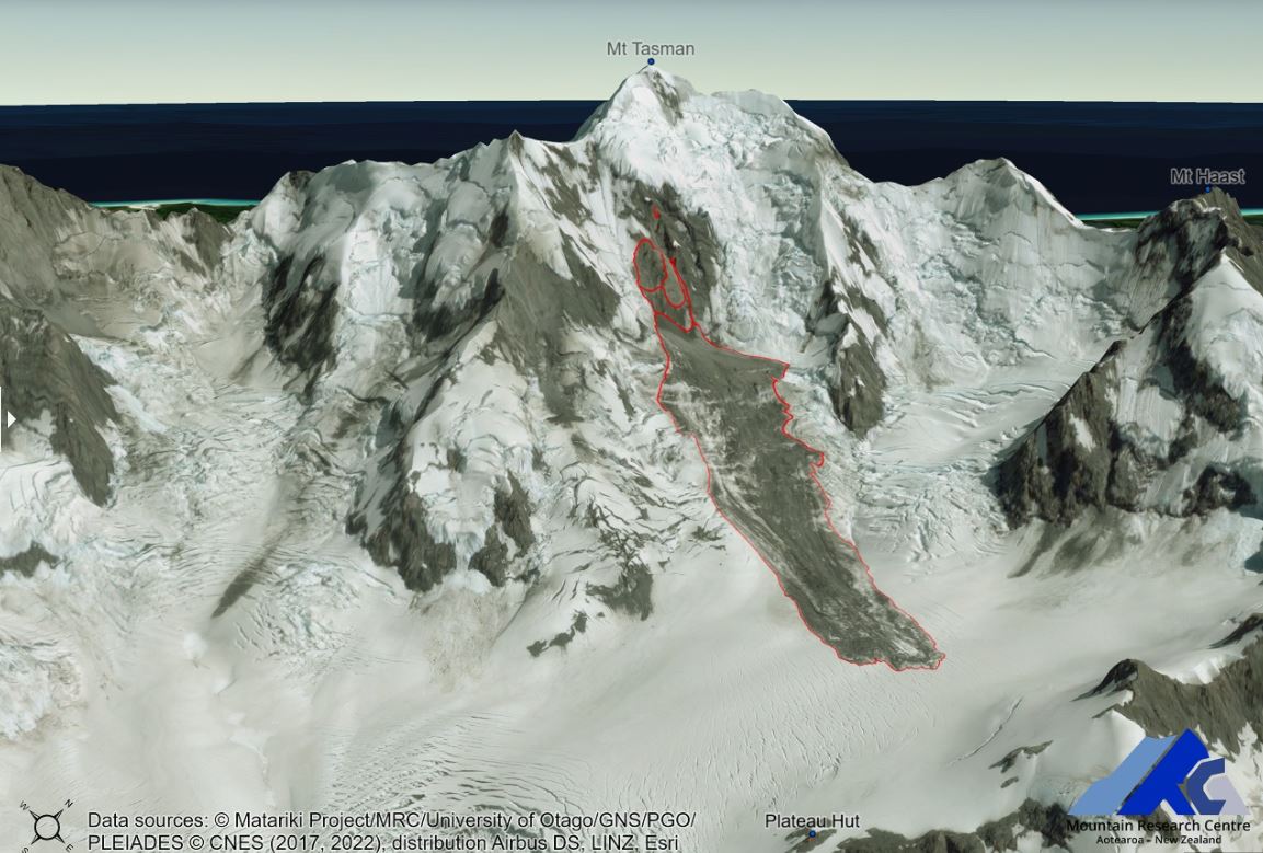
3D view of the February 2022 landslide on Mount Tasman in New Zealand. Image copyright of the Matariki Project, used with permission. Satellite image by PLEIADES, distribution Airbus DS.
.
The other event occurred at Beatrice in the Hooker Valley. The Matiriki Project team had identified the source as a creeping landslide, which duly collapsed. This might be interesting to look at using InSAR. This is a rather larger failure – the estimated volume is 704,000 cubic metres, with a runout distance of 1,020 m and a vertical height change of 435 m. The image below shows the landslide:-
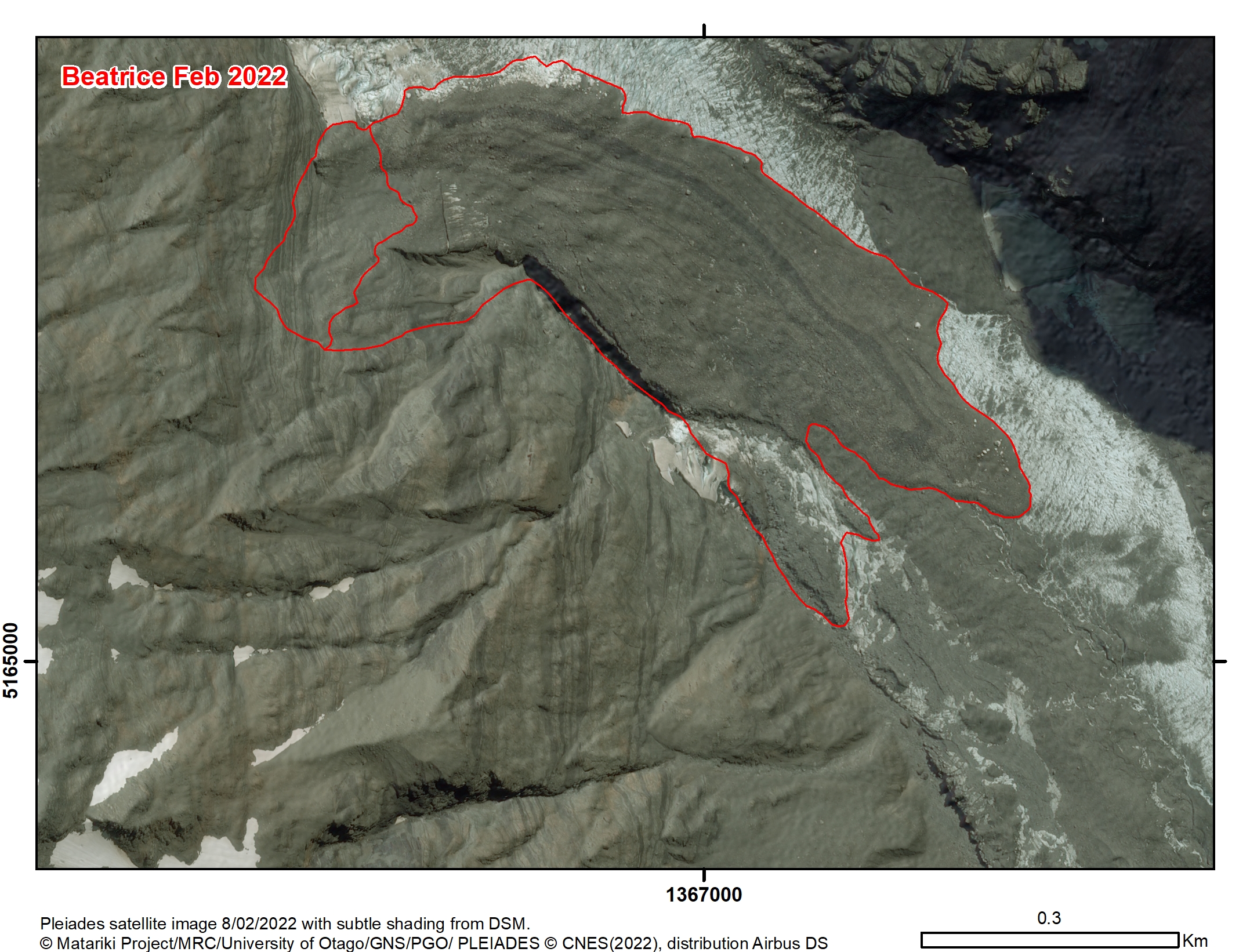
The February 2022 landslide at Beatrice in the Hooker Valley in New Zealand. Image copyright of the Matariki Project, used with permission. Satellite image by PLEIADES, distribution Airbus DS.
.
Again, this is quite spectacular when viewed in 3d:-
.
3D view of the February 2022 landslide at Beatrice in the Hooker Valley in New Zealand. Image copyright of the Matariki Project, used with permission. Satellite image by PLEIADES, distribution Airbus DS.
.
Interestingly, Simon points out that:
It looks to have dammed side streams and emergent subglacial water, which breached and eroded the deposit and remobilised material to form a braided supraglacial outwash fan stretching around 1 kilometre further down valley.
This is visible in the image above.
On the Matariki Project website there are some sliders that allow comparison of imagery before and after these landslides. It is well worth a look. Unfortunately WordPress doesn’t allow me to use them here.
9 February 2022
Dosquebradas: at least 14 killed in a landslide in Colombia
Dosquebradas: at least 16 killed in a landslide in Colombia
Heavy rainfall triggered a large landslide in the town of Dosquebradas in Colombia yesterday, killing at least 16 people, injuring 34 more. The landslide, which occurred at 6:25 am local time, buried six houses. El Tiempo has a good report (in Spanish – Google translate does a good job).
The newspaper El Spectador has a good image of the site, which consists of a shallow failure in a steep scarp:-
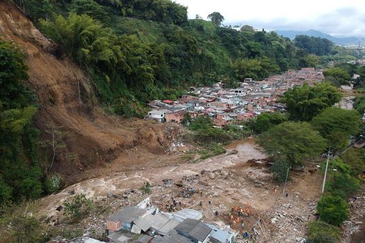
The 8 February 2022 landslide at Dosquebradas in Colombia, which killed 16 people. Image by Santiago Ramirez via El Spectador.
.
Note the location of a high density, informal settlement at the foot of the slope. The same area was impacted by another landslide on 5 October 1976, in which 63 people were killed and a further four were left missing.
Colombia has an excellent, very active landslide research and mitigation community, so some excellent information about this failure has been posted to Twitter. Helbert Schneider, a PhD student at Syracuse University, has tweeted two really interesting insights. The first provides drone footage of the site:–
At least 14 people died and 30 more went injured due to a soil slide in central Colombia.
A drone footage is available and shows the outcome of this tragedy…@davepetley https://t.co/h5YGyVS5AI
— Helbert García-Delgado (@HelbertSchneid1) February 8, 2022
.
Whilst the second provides an overview of the landslide risk at the site:
I've done some observations about the Pereira-Dosquebradas tragedy. First, using the footage available I tentatively located the fatal landslide. The base map corresponds to the landslide/flood hazard map for the city of Pereira reported in the Land use plan. 1/n pic.twitter.com/iOSFeZ3nYs
— Helbert García-Delgado (@HelbertSchneid1) February 9, 2022
In the long run, people may question the meaning of elaborating land use plans. Unfortunately, It seems more like a bureaucratic procedure rather than a risk management process…Meanwhile, vulnerable people are being killed by this ineffectiveness.
— Helbert García-Delgado (@HelbertSchneid1) February 9, 2022
.
In the same Twitter thread, Helbert makes the following observations:
Note how in the mentioned plan [in his first tweet above], the affected area is not recognized as a susceptible area to landsliding. Although the steep slope is north of the Otún River, on the Dosquebradas municipality side, the runout distance was enough to cross the stream…Most deaths occurred on the Pereira side of the Otún River. The available visual material is clear in that the south margin of the Otún River was heavily damaged and where most fatalities were located….Does this mean that geoscientists and engineers failed to recognize this possible scenario? The historical data shows that this area has been affected by fatal landslides in the past. Therefore, the scenario is not new or unexpected.
So, this is a case of known hazard and established risk, but the mechanisms have not been in place to protect the population. This is a scenario that we see over and over again across the world, with tragic outcomes. Colombia has a substantial landslide hazard – I’ve posted previously about research quantifying the level of loss, which provides a better analysis of an earlier analysis that I posted, whilst Sergio Sepulveda and I published an open access article a few years ago looking at patterns of landslide loss across South America (Sepulveda and Petley 2015)
.
Reference
Sepúlveda, S.A. and Petley, D.N. 2015. Regional trends and controlling factors of fatal landslides in Latin America and the Caribbean. Natural Hazards and Earth System Sciences, 15, 1821-1833, doi:10.5194/nhess-15-1821-2015.
8 February 2022
Planet Labs imagery of the 31 January 2022 mudflow in the La Gasca suburb of Quito
Planet Labs imagery of the 31 January 2022 mudflow in the La Gasca suburb of Quito
Last week I posted about the 31 January 2022 mudflow at La Gasca in Quito, Ecuador. Two loyal readers, Stephen Slaughter and Doug Clark, have kindly highlighted that a few days ago the sky was sufficiently clear for Planet Labs to capture a good PlanetScope image of the site, which is revealing:-
PlanetScope image of the site of the 31 January 2022 mudflow at La Gasca in Ecuador. Image collected on 3 February 2022, copyright Planet Labs, used with permission.
.
The track of the mudflow, in an existing channel, is clear, running approximately west – east across the middle of the image. It is clear that the volume was increasing along the track and just to the east of the centre of the image it appears to bifurcate. On the eastern side of the image the damage to the city can be seen, although with little detail. Interpretation is helped considerably by a drone video on the El Comercio website, which shows that the mudflow followed the incised channel to the north of the vegetated area just south of Teresa Silva, and then directly down the road network.
The resolution of PlanetScope images makes interpretation of mechanisms of initiation quite difficult, but it is interesting to take a look at the upper parts of the channel:-
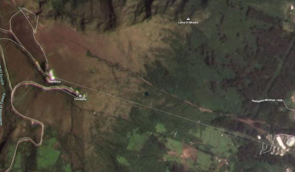
PlanetScope image of the upper part of the channel of the 31 January 2022 mudflow at La Gasca in Ecuador. Image collected on 3 February 2022, copyright Planet Labs, used with permission.
.
There is no obvious landslide on the terrain adjacent to the channel that might have been the initiating event for the mudflow. It seems likely therefore that it started either as a very localised failure that is too small to resolve or as an in-channel event in which the flow initiated bank erosion and/or entrainment of the channel bed. It is clear that the majority of the mudflow that struck La Gasca was formed from material eroded from within the channel.
With climate change causing an increase in rainfall intensity, there is a high likelihood of a repeat of this event. Mitigation of the channel is needed, along the line of the Japanese sabo engineering approach (ideally using more environmentally-conscious engineering approaches than is sometimes the case).
Finally, many thanks to Stephen and Doug for highlighting the imagery to me. Finding time to write this blog is a challenge at times, it is made so much easier when loyal readers provide help like this.
.
Reference
Planet Team (2022). Planet Application Program Interface: In Space for Life on Earth. San Francisco, CA. https://www.planet.com/
7 February 2022
An unusual embankment failure near to Northampton
An unusual embankment failure near to Northampton
In the late autumn of in 2021 I was driving south from Sheffield to visit my daughter near to London in the UK. I was on the M1 motorway close to the town of Northampton, in heavy traffic, when I fleetingly spotted what appeared to be surprisingly large, very new landslide in an embankment. The location was very close to junction 15A; the landslide was in a newly constructed, steep berm around a new warehouse site.
Of course, it wasn’t possible to stop to take a look, so my view of the site was very brief. I drove the same road this weekend – the failure has now been excavated.
However, interestingly, the landslide has been captured on Google Street view, from several perspectives. This image was collected in October 2021:-
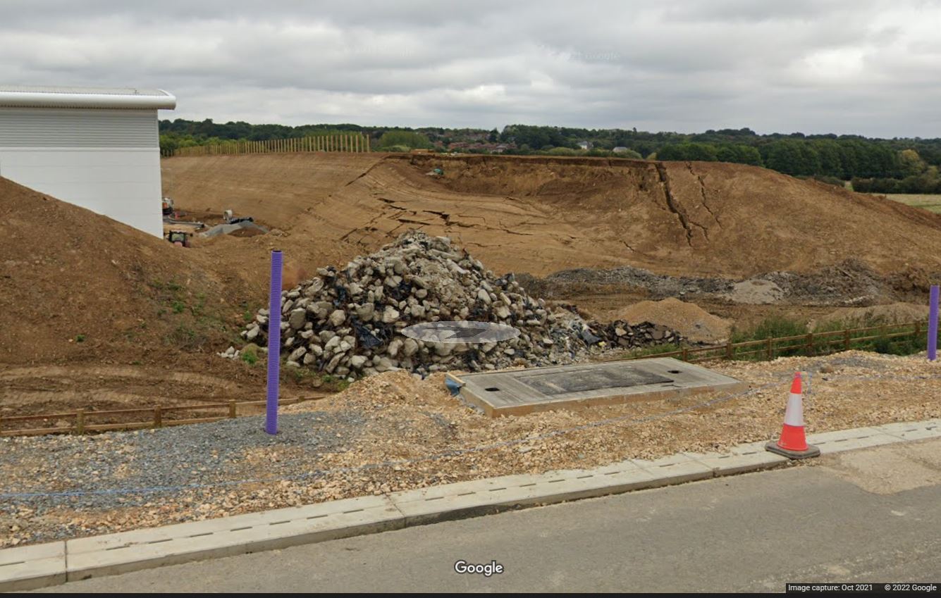
The embankment failure near to Northampton. Image from Google StreetView.
.
The location is 52.207, -0.933. The most recent Google Earth image shows the embankment under construction in September 2021.
This is an alternative view from a few metres further along the road:-
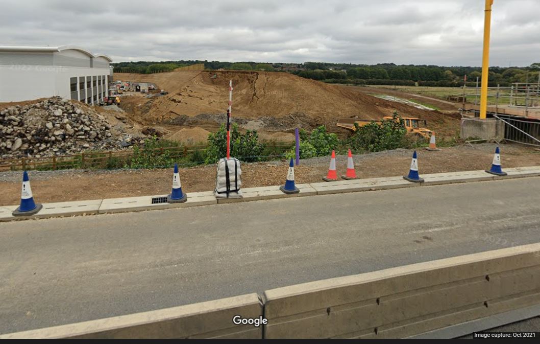
Another view of the embankment failure near to Northampton. Image from Google StreetView.
.
This appears to be a rotational failure / slump in the embankment. The mechanisms of failure are quite complex, with considerable plastic deformation on the margins of the failed block:-
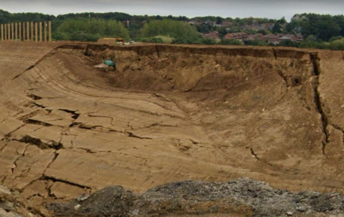
Detailed view of the embankment failure near to Northampton. Image from Google StreetView.
.
Unsurprisingly, there is nothing online about this landslide. I’m quite intrigued by two aspects of it though. First, what caused this section of the embankment to fail whilst the remainder of the embankment remains intact? Was it built to a different specification (for example different materials or drainage), or using a different method, or is there something about the ground conditions that meant that it was susceptible to failure?
And second, the remaining embankment is remarkably steep and high. How confident can the designers be that a similar failure won’t happen at another location on this embankment?
4 February 2022
The 1979 Nice Airport landslide and tsunami
The 1979 Nice Airport landslide and tsunami
On 16 October 1979 a significant tsunami hit the coast of southern France close to Nice, between the border with Italy and the town of Antibes. In places the waves reached 3.5 m in height and travelled up to 150 m inland. Casualty figures are unclear, but estimates range between 8 and 23 fatalities.
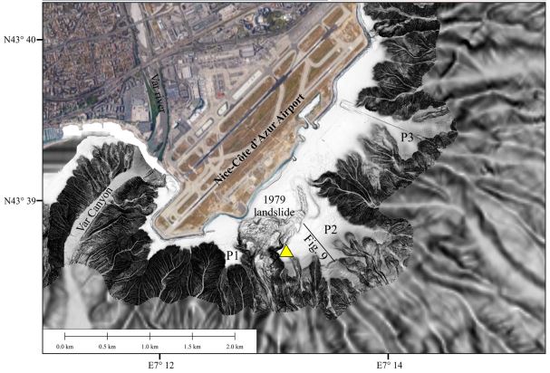
At Nice airport, a section of fill slope failed during this event, killing seven people. This landslide involved between 2 and 3 million cubic metres of fill that was being emplaced for the new port of Nice, but also involved about 7 million cubic metres of the underlying clay-silt, giving a total volume of 10 million cubic metres. The diagram below, from Seed et al. (1988) provides details of the location:-
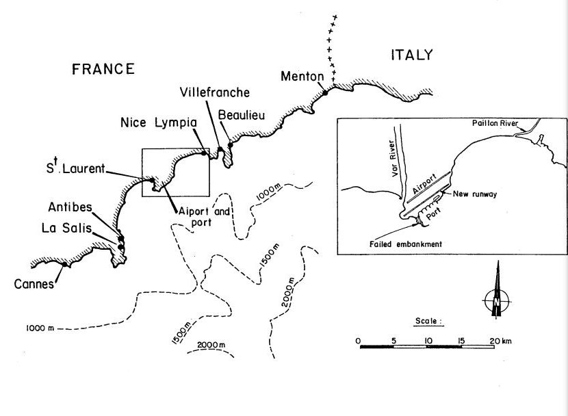
The location of the 1979 Nice airport landslide. Note the section of coast that was affected by the tsunami, which extended from Antibes to the Italian border. Image from Seed et al. (1988).
.
In the hours following the disaster, two submarine cables were severed offshore from the French coast. One cable was cut after 3 hours and 45 minutes after the failure at Nice airport, and was located about 85 km from the site, whilst the other was cut 8 hours after the failure, 114 km from the slide area. These severed cables clearly indicated that there had been a massive submarine landslide, which was linked to the tsunami. No seismic event had been recorded. Subsequently, a very large submarine landslide deposit has been mapped; this is estimated to have a volume of 150 million cubic metres.
In the aftermath of the disaster, two theories emerged as to the sequence of events. In one hypothesis, the landslide at Nice airport entered a submarine canyon located offshore, triggering the much larger submarine landslide. The canyon is visible in the image below:-
The sea floor topography offshore Nice airport. The location of the 1979 landslide is shown, as is the submarine canyon. Image from Courboulex et al. (2020).
.
In the second hypothesis, the submarine landslide initiated naturally, triggering a tsunami. This in turn triggered the failure of the fill at Nice airport.
Intuitively, based on our current understanding of these events, the former hypothesis seems more credible to me. Interestingly, a review of the event a few years later (Seed et al. 1988) concluded that the most likely explanation was the second hypothesis, that the large scale submarine landslide occurred first.
However, more recent investigations have reversed that finding, determining with confidence that the first event was the failure at Nice airport (Dan et al. 2007). Critically, those responsible for the construction of the fill area had failed to appreciate the presence of a sensitive clay layer in the underlying sediments. In the days leading up to the disaster, heavy rainfall drove seepage of fresh water into the sediments, probably triggering failure in this weak layer, initiating the sequence of events.
Many lessons were learnt from this event. Perhaps most importantly, signs of distress were observed in the fill in the days prior to the collapse, including the development of cracks, settlement and embankment failures. Such warning signs should not be ignored.
.
References
Courboulex, F., Mercerat, E., Deschamps, A. et al. 2020. Strong Site Effect Revealed by a New Broadband Seismometer on the Continental Shelf Offshore Nice Airport (Southeastern France). Pure and Applied Geophysics, 177, 3205–3224.
Dan, G., Sultan, N., Savoye, B. 2007. The 1979 Nice harbour catastrophe revisited: trigger mechanism inferred from geotechnical measurements and numerical modelling.
Marine Geology 245 (1-4), 40-64.
Seed, H., Seed, R., Schlosser, F. et al. 1988. The landslide at the Port of Nice on October 16, 1979. College of Engineering, University of California.
2 February 2022
The disastrous 31 January 2022 mudflow in the La Gasca suburb of Quito, Ecuador
The disastrous 31 January 2022 mudflow in the La Gasca suburb of Quito, Ecuador
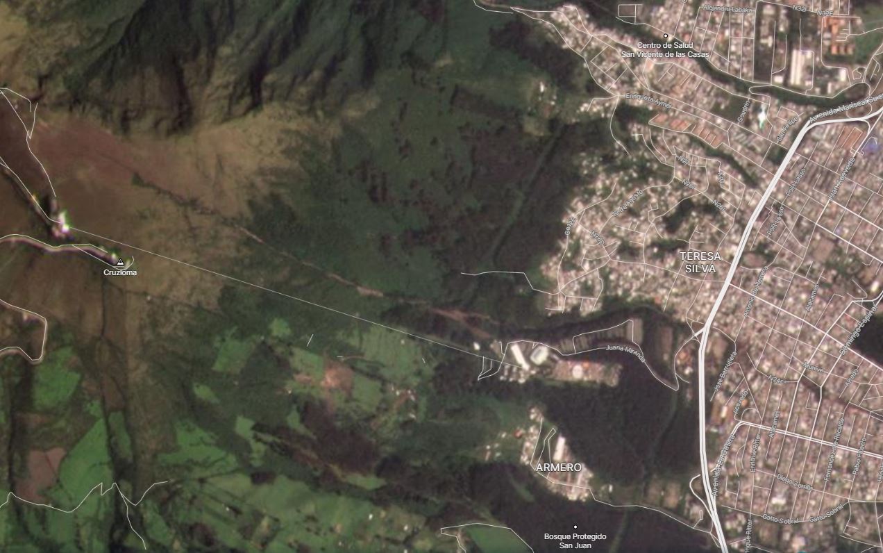
On 31 January 2022 heavy rainfall triggered a disastrous mudflow in the La Gasca suburb of Quito in Ecuador. There is a detailed set of articles about this event on the El Comercio news website. In an article posted yesterday it records the losses as 24 known fatalities, a further 12 people missing and 48 people injured. This is likely to be updated during the day today.
Extremely heavy, short duration rainfall (7.5 cm in one hour has been reported) was the trigger for the mudflow. The Google Earth image below shows the La Gasca suburb and the local topography:-
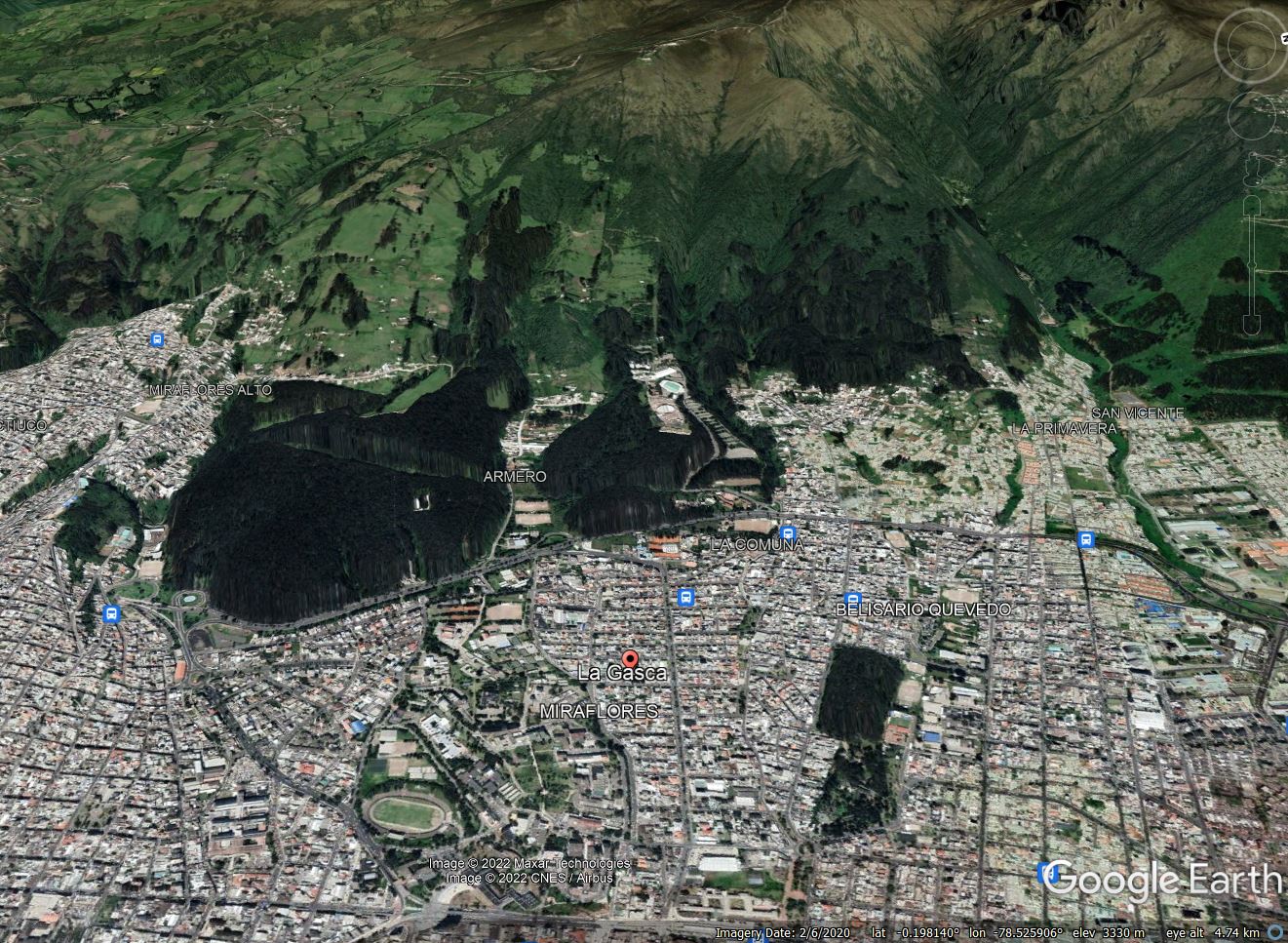
Google Earth image of the area affected by the 31 January 2022 mudflow in Quito, Ecuador.
.
The mudflow has clearly originated on the steep slopes and channels above the city. The elevation difference between the peak and La Gasca is over 1,000 m.
There is dramatic footage of the event as it occurred on Youtube, some of which makes uncomfortable viewing. The footage below gives an idea of the nature of the event:-
.
There is also drone footage of the aftermath:-
.
The image below gives an impression of the scale of the damage:-
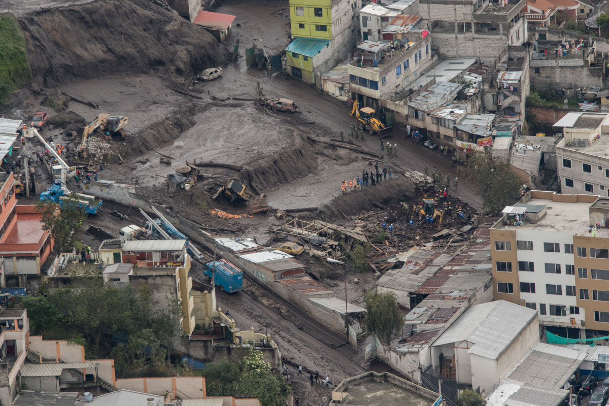
The aftermath of the 31 January 2022 mudflow in La Gasca, Quito. Image by: Carlos Noriega / El Comercio.
.
Interestingly, this area appears to have been affected by a similar mudflow on 25 February 1975, when a mudflow originated from the Pambachupa ravine, affecting the La Mariscal neighbourhood, close to La Gasca. On that occasion two people were killed and a further five were injured.
Perhaps surprisingly, the municipal authorities have ruled out deforestation as being a factor in this event.
31 January 2022
The December 2021 landslides in Malaysia
The December 2021 landslides in Malaysia
In December 2021 heavy rainfall in Malaysia triggered landslides that caused extensive damage. For example, The Star reports that on 18 December landslides closed the Kuala Lumpur-Karak Highway, leaving about 450 people stranded on the road. The worst affected state was Selangor, where ten people were reported to be missing, primarily as a result of flooding.
Loyal reader Riza Aziz has carefully collated some information about the landslides associated with this heavy rainfall. Riza has highlighted the following mountainous areas affected:
Karak in Pahang state
Google Maps link: https://goo.gl/maps/zcPfTqMSU1j64bEr9
Debris flows in multiple areas, the main highway connecting the east and west coasts was blocked by mud and debris for a week. Downstream towards Temerloh town in Pahang state, water levels rose 1 meter higher than the road surface which is on an embankment above the surrounding countryside. I passed by two days after Christmas and I saw mature oil palm trees completely covered in mud. Maybe 20 feet max water level?
Kuala Klawang in Negeri Sembilan state
Google Maps link: https://goo.gl/maps/Z7CfBycLyRUDHNnk8
Route N32 that passes through here is a favourite among cyclists and motorcycle riders for the tight turns and constantly changing elevation. It has become a muddy trail with landslides at every turn. Some landslides looked like steep roadcut slopes that moved when they became too waterlogged. Other slides were massive events with an upstream source that sometimes scoured away the overlying soil.
Riza has kindly provided the following images of some of the landslides-
A landslide from the rains in December 2021 on Route N32 in Malaysia.
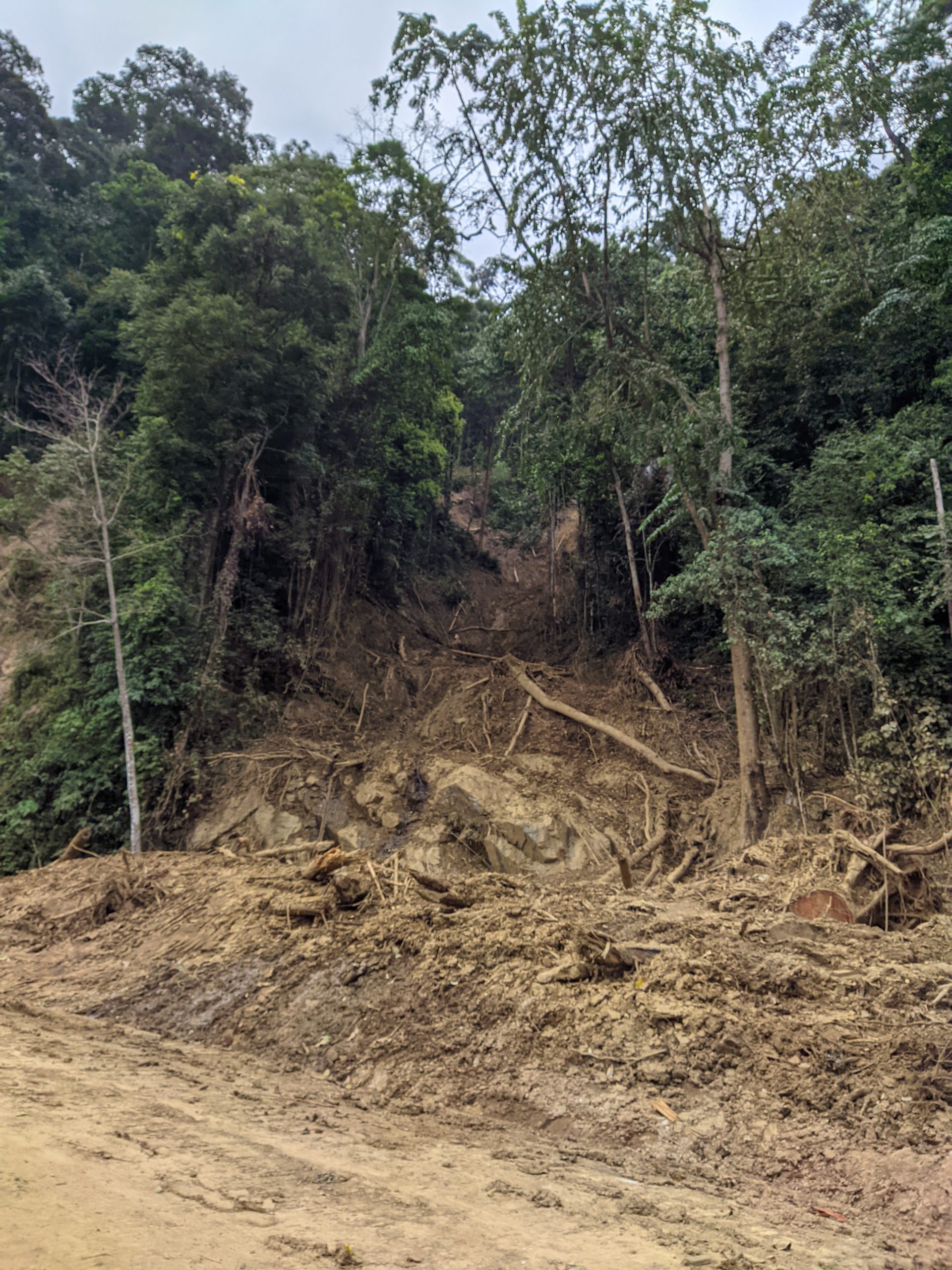
A flow from the rains in December 2021 on Route N32 in Malaysia.
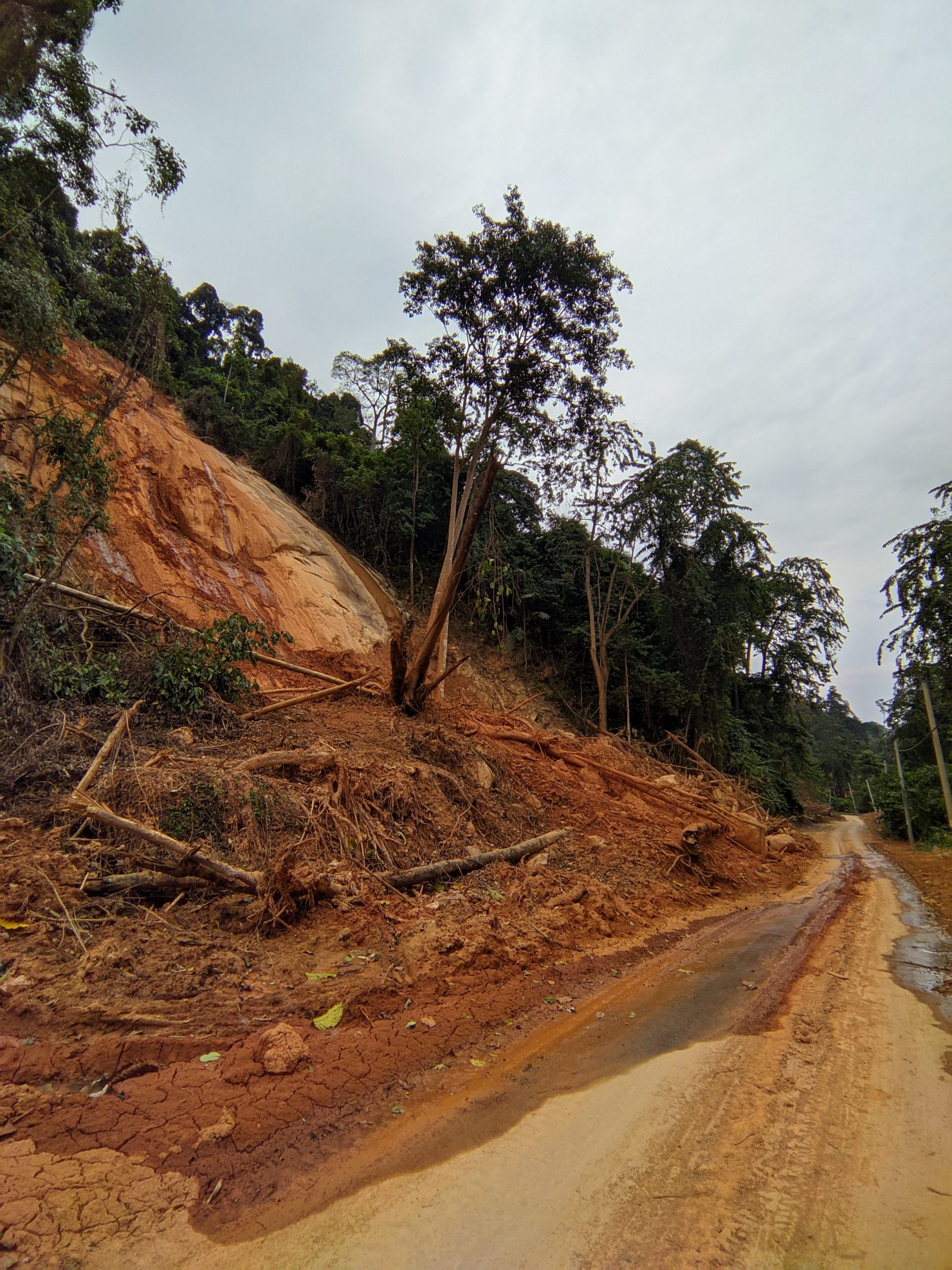
A shallow landslide from the rains in December 2021 on Route N32 in Malaysia.
.
Hulu Langat town in Selangor state
Google Maps link: https://goo.gl/maps/fSqzGqD1akMdyd7x8
This town was downstream of the previous area and some parts were hit hard by flooding and debris flows. It was previously a weekend mountain retreat for city folks from Kuala Lumpur.
28 January 2022
Seri Kembangan: an impressive cut slope failure in Kuala Lumpur, Malaysia
Seri Kembangan: an impressive cut slope failure in Kuala Lumpur, Malaysia
On 25 January 2022 a large cut slope failure occurred on the banks of a drainage channel in Seri Kembangan, a suburb of Kuala Lumpur in Malaysia. This event was notable because it was caught by local people on a set of spectacular videos. For example, this one provides a good perspective on the event from two different viewpoints, and includes some images of the aftermath:-
.
In the second video in the above compilation a driver can be seen rescuing a car a few seconds before the collapse. That was a lucky escape. Reports indicate that cracks formed in the road in the hour or so ahead of the collapse, and that a number of other cars were moved before the videos started,
The site of the collapse, Jalan LP 1A/2 Lestari Perdana, Serdang, is shown in the Google Streetview image from January last year:-
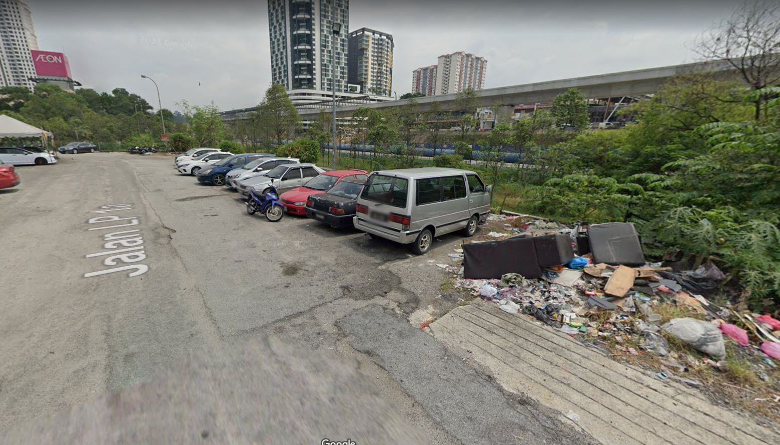
The site of the collapse at Seri Kembangan in Malaysia. Image from Google Streetview.
.
It is interesting to note the poor state of repair of the site and the patches in the road surface. The best image that I’ve tracked down of the aftermath is this one, from MyMetro:-
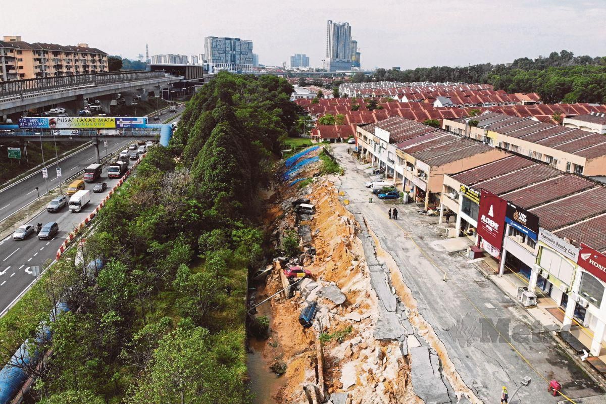
The aftermath of the landslide at Seri Kembangan in Kuala Lumpur, Malaysia. Image from MyMetro, taken by Aizuddin Saad.
.
News reports indicate that works are now underway to secure the site with sheet piles whilst a permanent solution is found. This is a pragmatic approach – note the arcuate cracks extending through the road surface in the image above. There are also calls now for an enhanced safety regime from slopes in Malaysia, along the lines of the processes in Hong Kong.
In many ways this is reminiscent of the 2014 retaining wall collapse in Charles Town, Baltimore, which also sent cars tumbling into a drainage channel.
 Dave Petley is the Vice-Chancellor of the University of Hull in the United Kingdom. His blog provides commentary and analysis of landslide events occurring worldwide, including the landslides themselves, latest research, and conferences and meetings.
Recent Comments