15 March 2022
A drone video of the B4069 Lyneham landslide
Posted by Dave Petley
A drone video of the B4069 Lyneham landslide
On 25 February I blogged about the Lyneham landslide, a substantial failure on the B4069 road at Dauntsey Banks in Wiltshire, in southern England. With thanks to Stuart Lewis, who highlighted in a comment to that original post that a video has now been posted to Youtube that provides drone footage of the landslide:-
.
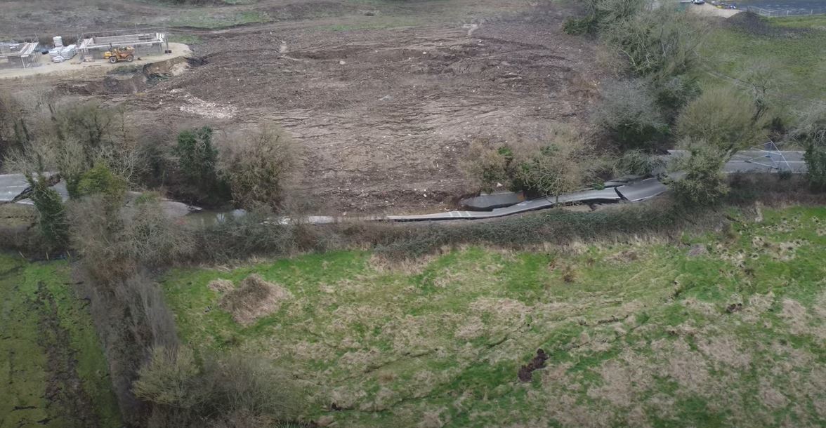
The video, which was collected on 8 March 2022, provides both aerial views and static shots of this most interesting landslide. In my original post I noted that there appears to have been construction activity in the field directly upslope of the road. The video provides clarification on this. The image below is a still from the video – it is most interesting:-

The Lyneham landslide, showing construction activity in the field upslope of the road. Still from a video posted to Youtube.
.
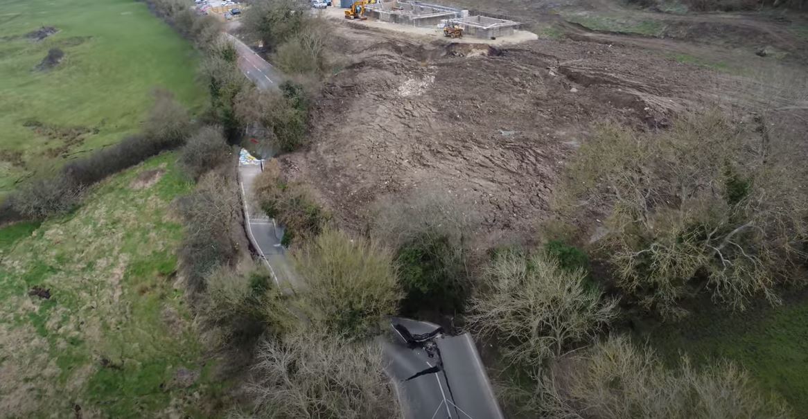
Here is another view of the site:-

The Lyneham landslide, showing construction activity in the field upslope of the road. Still from a video posted to Youtube.
.
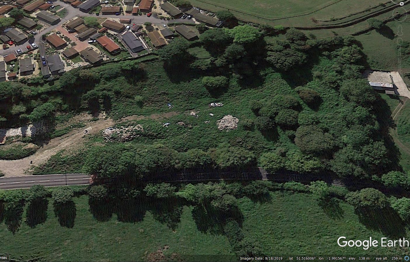
I think there are a few things to note here. First, the landslide has extended most of the way through this field, with the largest rear scarp area being located adjacent to the pad on which the new buildings are being constructed. Second, the failed section of road corresponds very closely to the eastern boundaries of the field in which construction was being undertaken. This is particularly evident in the first of the two images above. Third, it appears that although building construction has occurred in only a part of this field, it appears that the surface cover throughout has been changed. This is the field in 2019, from Google Earth:-

Google Earth image of the site of the Lyneham landslide in Wiltshire.
.
I am speculating here, but has the field been regraded (note the scarps downslope of the tracks in the second image)?
Of course, I cannot provide a link between the activities in this field and the reactivation of the landslide – that could only be established through a proper site investigation. I am sure that this is being undertaken. There are other possible causes. But it is certainly a line of enquiry that is worthy of deeper examination.
As I noted in my first post, this is an area that shows clear signs of previous landslide activity, and the failure appears to me to be a reactivation. This highlights why it is important to get input from an engineering geomorphologist before undertaking works such as this in these areas.


 Dave Petley is the Vice-Chancellor of the University of Hull in the United Kingdom. His blog provides commentary and analysis of landslide events occurring worldwide, including the landslides themselves, latest research, and conferences and meetings.
This is criminal. Wiltshire Council (or whoever granted planning permission) should personally be made to pay for the road repairs. I moved to this area in ’73 and even then (and living about 12 miles away) I and everyone else knew there was ‘creep’ on this slope. The road was often cracked, but never to this extent.
There has been a great deal of research on Lyneham Banks (as its known locally.), mainly by geology students from Bristol, I believe, over the years.
No doubt, as usual, no one will be held responsible and the cost of repairs will fall the the Council Tax payers of Wiltshire.
I would speculate that the road has been moving for a while as evidenced by the 3 layers of asphalt seen in several sections of road video.
Please comment on the cracks in the soil in the field on the left (below the road – 5 seconds in to the video) and what that may indicate about the overall movement of this slide.
Is it possible that the road failed first and released the toe of the slope above the road?
[Yes that is possible. D.]
Don’t think an Engineering Geomorpholgist is necessarily required – you just need someone to look at the geological map. The BGS shows all that field and the one below as a landslip. Not the best place to put a lot of fill
I was looking for historical imagery for this site in Google Earth, but there seems to be no high-resolution imagery before 2019. Then I realized that the road is very close (less than 1 km away) from a large military base in Lyneham, so I guess Google either chose to or was requested to not post high-resolution imagery of the area.
RE Landslide is there old coal mines in the area long forgotten about, as this could also be a cause effect on land,