
11 April 2022
Bedruthan Steps: another “face” in a landslide scar
Bedruthan Steps: another “face” in a landslide scar
Over the years I have collected a set of stories in which a “face” apparently appears in a landslide scar (and other examples of landslide weirdness). For example, in 2015 an image of Jesus apparently appeared in the scar of a landslide in the San Francisco area of Putumayo in Colombia.
Devon Live has a really good example, based upon a rockfall that occurred in a sea cliff at Bedruthan Steps in Cornwall:-
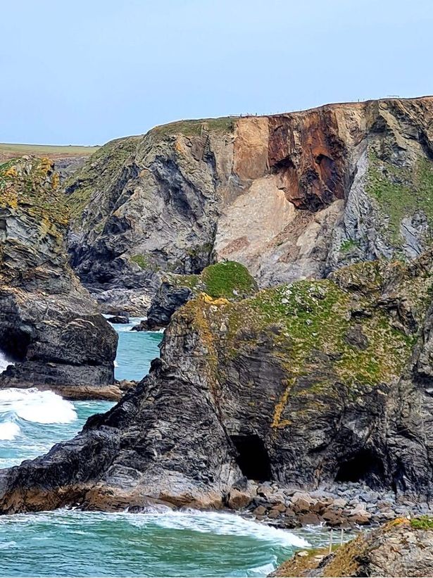
The image of a face following a rockfall at Bedruthan Steps in Devon. Image by Louise Coe via Devon Live.
.
In reality of course this is the fascinating phenomenon know as face pareidolia, in which the human brain is programmed to identify faces rapidly. At times this mechanism identifies faces in inanimate objects – the theory is that the disadvantages of doing so are outweighed by the advantages of rapid facial recognition. Interestingly, recent research has indicated that we are biased towards seeing male rather than female faces in such situations.
Most rockfalls are defined by pre-existing joints or other discontinuities in the rock mass, meaning that the scar contains strong linear features. In many cases, the discontinuities are not random, meaning that patterns emerge. It is unsurprising that these occasionally show similar features to faces.
In the case of Bedruthan Steps, the discontinuities have defined two inverted wedges that form the angular “eyes” of the face. There is a less well-defined wedge with a similar form that has created the “nose”. These joints can be seen in other locations across the rock mass.
7 April 2022
The long term history of fatal landslides in Colombia
The long term history of fatal landslides in Colombia
Colombia is one of the most landslide-prone countries in the world. In the last few days heavy rainfall has triggered flooding and landslides, including at least one death in Marulanda Municipality in Caldas. Understanding the patterns of landslides in time and space is an important element of managing the risk in such countries.
In a paper just published in the journal Landslides (Garcia-Delgado, Petley et al. 2022), an international team has constructed a long term dataset of fatal landslides in Colombia, extending right back into historical times. This comprises 2.351 individual fatal landslides causing 37,959 fatalities. The earliest event was in October 1743, but the vast majority have been recorded since 1912, when the data becomes more robust.
The temporal pattern of the landslides in time is really interesting – this is illustrated in the graph below:-
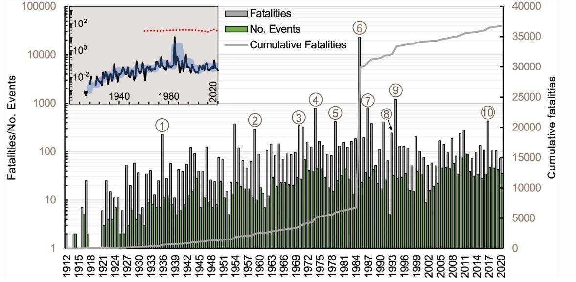
Numbers of landslides and landslide fatalities in Colombia through time. Graph from Garcia-Delgado et al. (2022). The figure caption is: Temporal distribution of deadly landslides, their fatalities and cumulative total of fatalities from 1912 to 2020. The numbers in circles correspond to the top 10 deadliest events as follows: (1) Túquerres (9 January 1936; n = 170 fatalities); (2) Ibagué (29 June 1959; n = 250); (3) Chiriguaná (10 November 1970; n = 123); (4) Quebrada Blanca–Guayabetal (28 June 1974; n = 400); (5) El Playón (25 November 1979; n = 300); (6) Armero–Chinchiná (13 November 1985; n = 23,084); (7) Villatina–Medellín (28 September 1987; n = 562); (8) Andes (26 April 1993; n = 120); (9) Páez (6 June 1994; n = 1100); and (10) Mocoa (31 March 2017; n = 333). To check the location of these events please refer to Fig. 2. The upper-left inset shows annual fatalities normalised by the number of events.
.
This is an incredibly rich and interesting figure. Note the huge jump in the cumulative fatalities associated with the lahars caused by the Armero–Chinchiná lahars, which killed over 23,000 people). Also notable is the increase in fatalities through the period from 1912 to the 1970s. Since then the number of fatal landslides has remained high but the strong positive growth has slowed. The two decades with the highest numbers of fatalities were 2001-2010 and 2011-2020. The inset graph normalises fatalities with the population (which has grown over the study period), suggesting that the per capita rate of loss has remained about the same.
The paper looks at this data in a great deal more detail, including the role of mining and road construction in landslide trends, and also the impact of the El Nino / La Nina cycle. I will return to these themes in subsequent posts. Putting together a dataset like this is an epic job – Helbert Garcia-Delgado of the Department of Earth and Environmental Sciences at Syracuse University Servicio Geológico Colombiano, who led the research, has been brilliant.
.
Reference
Garcia-Delgado, Petley, D.N., Bermúdez, M.A. and Sepúlveda, S. 2022. Fatal landslides in Colombia (from historical times to 2020) and their socio-economic impacts. Doi: https://doi.org/10.1007/s10346-022-01870-2.
6 April 2022
A tailings dam failure in Wenquan Township Jiaokou County, Shanxi Province, China
A tailings dam failure in Wenquan Township, Shanxi Province, China
Yesterday my friends at World Mine Tailings Failures alerted me to a report from China of a tailings facility failure in Wenquan Township, Jiaokou County, Shanxi Province, China. The report provides limited detail, the salient points of which are as follows:-
On the afternoon of March 27, a landslide occurred in a material yard of Shanxi Daoer Aluminum Co., Ltd.
According to reports, at around 17:00 on March 27, a tailings pond of Daoer Company, located in Wenquan Township, Jiaokou County, broke a dam. Part of the factory area was buried; a large pit was formed in the tailings pond, the dam body was flushed with a gap of about 70 to 80 meters, and the mud accumulation blocked the local road...According to the report of the People’s Government of Jiaokou County, after preliminary inspection, a landslide occurred in a material storage yard of Daoer Company in the county, causing 7.5 mu of arbor forest land to be buried, more than 200 meters of seasonal ditches and rural roads were blocked, and part of the surrounding walls of adjacent enterprises were washed away. No casualties were found.
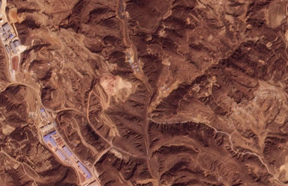
I have been able to track this event down on Planet imagery. The area around Wenquan Township is decimated by mining, but the tailings failure stands out quite clearly:-
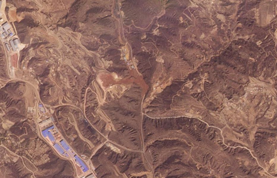
Satellite image of the 27 March 2022 tailings dam failure at Wenquan Township in Shanxi Province China. Image courtesy of Planet, used with permission.
.
The location of the tailings dam failure is 37.1059, 111.4301. The mobilised tailings appear to have moved about 700 m from the crest of the scar to the toe of the waste, or about 500 m from the edge of the failed retaining structure to the toe of the dam.
.
I have created a Juxtapose slider to compare a Planet image from before the failure (collected on 7 March 2022) with the one after (collected on 28 March 20222 – the day after the collapse):-
.
There are inevitable resolution limitations in this genuinely amazing daily Planet imagery, but it confirms aspects of the report in the news report. In the runout zone the tailings have clearly partially inundated an industrial facility – presumably the concentrator – and a road is blocked. The remainder of the tailings are mostly covering vegetated slopes.
The most recent (5 April 2022) imagery suggests that the road has been cleared and the tailings have been covered in a grey material. I am unsure as to what this might be.
The Wenquan Township event is not a large tailings failure, and the runout is comparatively modest. Nonetheless, it is of concern given the number of such facilities in China.
.
Acknowledgement
Planet Team (2022). Planet Application Program Interface: In Space for Life on Earth. San Francisco, CA. https://www.planet.com/
5 April 2022
Mount Bolu: an interesting case study of a tunnel portal landslide in Turkey
Mount Bolu: an interesting case study of a tunnel portal landslide in Turkey
On 2 April 2022 heavy rainfall triggered an economically significant landslide in at Mount Bolu in Turkey. The landslide occurred after a spell of rainfall that in places has fallen onto snow. This is a recipe for landslides in upland areas.
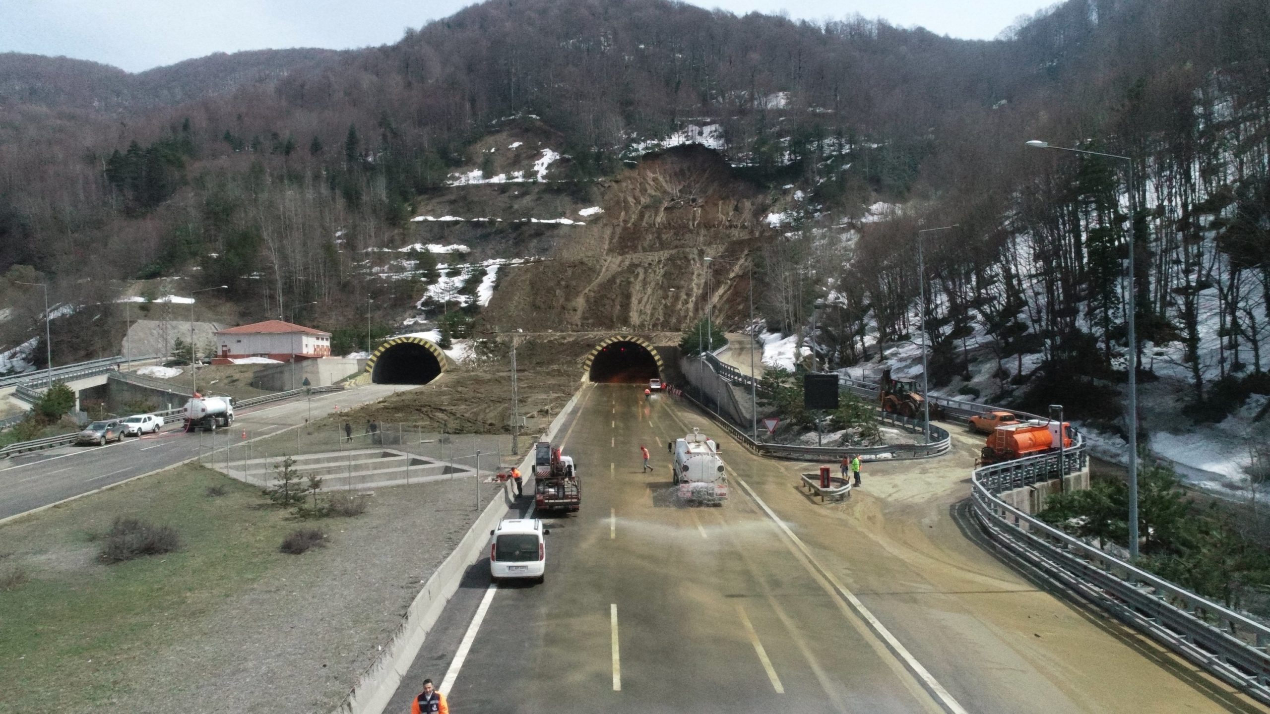
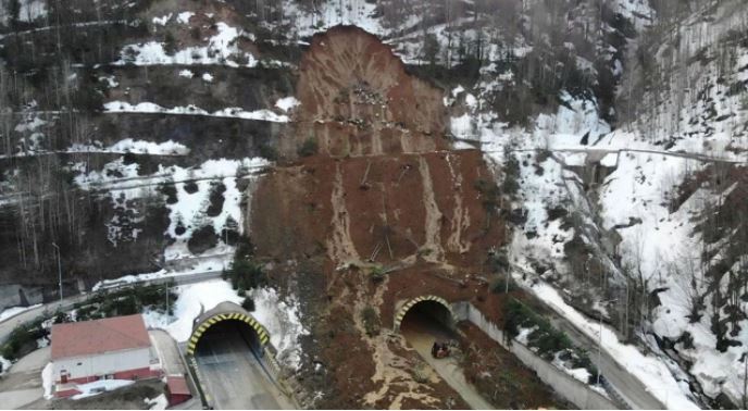
The Mount Bolu Tunnel landslide is interesting though. It has blocked four lanes of the D-100 road, a critical east-west connection across the north of Turkey. This is an image of the landslide:-
The aftermath of the landslide at Mount Bolu in Turkey. Image by AA via the Daily Sabah.
.
This is an alternative view that shows the landslide source more clearly, as well as some of the debris blocking the carriageway:-
The landslide at Mount Bolu in Turkey. Image from https://www.turkiyegazetesi.com.tr/.
.
The site of the tunnel is at 40.7578, 31.4504. It is clearly visible on Google Earth. The tunnel was completed in 2007.
There are some very interesting images online of the site of this landslide prior to the 2 April 2022 landslide. This image for example shows the tunnel portals and the slope above:-
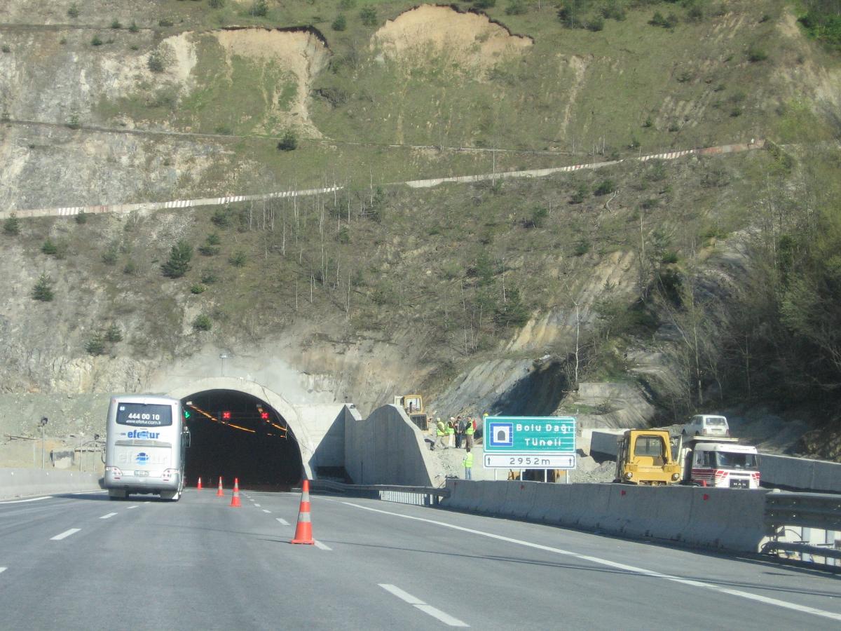
Archive image of the site of the Mount Bolu landslide, showing the pre-existing landslide scarps. Image from https://structurae.net/.
.
The archive of Google Earth imagery does not seem to indicate that further works have been undertaken to stabilise this slope, although of course satellite/aerial imagery has limitations. But on first inspection this is an ugly slope to be located above a tunnel portal on such an important highway, especially in a region that is seismically active.
The debris has taken 44 hours to clear, but the road has now reopened. The images suggest that further works will be needed on the slopes at this site, both in the scar of the 2 April 2022 landslide and on the slope to the left of it (as seen in the images), which appears to be another potential landslide site.
Northern Turkey has been suffering from a wave of landslides in recent days:-
Rapid snow melts have triggered more than 400 landslides in northern Turkey (in Bolu, Bartin, Samsun, Ordu, and Trabzon) in the last week. This foehn effect looks like will continue along the next week. Continue the landslide watch. Video credit @ihacomtr pic.twitter.com/oUfexjgOJH
— Tolga Gorum (@TolgaGorum) April 3, 2022
4 April 2022
Praia de Itaguaçu: one of a series of destructive landslides in Brazil
Praia de Itaguaçu: one of a series of destructive landslides in Brazil
On Saturday 2 April 2022 a series of landslides were triggered by heavy rainfall in the state of Rio de Janeiro in Brazil. In total 16 people are known to have died, the majority of whom lost their lives in landslides. The picture is a little confused at the moment, but reports include a mudslide in the town of Paraty, which killed two children and injured four people; another landslide in Paraty that killed a mother and seven of her children; and a landslide in the Monsuaba neighborhood of Angra dos Reis, which killed eight people, including four children. Three more people are missing in Monsuba. You will see that the total fatalities in the events described above is greater than the reported death toll, so I await greater clarity.
One major landslide occurred at Praia de Itaguaçu, a popular beach on Ilha Grande in Angra do Reis (note that there are several beaches with this name in Brazil). There are reports that four people may have been killed. There is a video taken from a boat showing the aftermath of this large landslide that has been widely tweeted, such as below:-
Impressionante | Um deslizamento de terra atingiu a Praia de Itaguaçu em Ilha Grande, Angra dos Reis. A faixa de areia do local desapareceu após queda da barreira. Ainda não há informações de feridos. #sbtrio #sbt pic.twitter.com/xrSdpSIgOL
— SBT Rio (@sbtrio) April 2, 2022
.
This includes the following view of the landslide:-
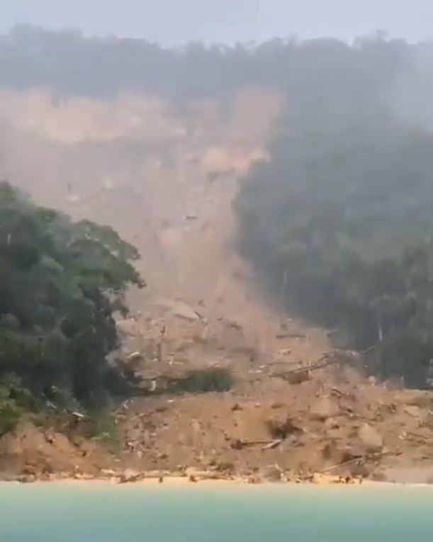
The aftermath of the 2 April 2022 landslide at Praia de Itaguaçu in Brazil. Image from a video that has been widely tweeted.
.
Once again we await better imagery, which is likely to become available today, although further rain is forecast in this area.
Back in 2015, Sergio Sepulveda (now of Simon Fraser University) and I analysed data on landslides in Central and South America (Sepulveda and Petley 2015 – available open access). We noted that there are two annual peaks of landslides in South America, one in January and one in April. As such, these landslides fit the annual pattern, but the current La Nina conditions may be playing a role in intensifying the rainfall that has triggered this most recent series of disasters.
.
Reference
Sepulveda, S.A. and Petley, D.N. 2015. Regional trends and controlling factors of fatal landslides in Latin America and the Caribbean. Natural Hazards and Earth System Sciences, 15, 1821-1833, doi: 10.5194/nhess-15-1821-2015.
31 March 2022
The mechanisms of the Derrybrien peatslide
The mechanisms of the Derrybrien peatslide
On 16 October 2003 a large peatslide occurred at the site of an under-construction windfarm in Derrybrien in the Republic of Ireland. This was one of the a number of such landslides that have occurred in Ireland in recent years, but it has been particularly high profile for the fact that the European Court of Justice made a ruling against the Irish government on the basis that an environmental impact assessment was not properly produced ahead of the works. Construction at the site was temporarily suspended, but the works were completed in 2006. The Derrybrien Wind Farm remains in operation today.
Aidan Forde kindly highlighted on Twitter that the Remedial Environmental Impact Assessment was published in August 2020 (better late than never I guess), which provides some detail of the mechanisms of the 2003 landslide. The report contains this description of the landslide:
The peat slide source area contained approximately 450,000 m^3 of peat at the time of the slide and it is estimated that approximately 250,000 m^3 of this material flowed from the source area into the downslope stream where it was routed down the mountain slopes to an elevation of approximately 200 mAOD where it spread out on a relatively flat area of agricultural land and to approximately the Black Road Bridge. Following some heavy rainfall, the debris material was forced further downslope along the Owendalluleagh River channel before reaching a phase of dispersion in the river water approximately 6.9 km downstream of the source area.
And:
At the time of the failure, peat was being excavated from the site of the turbine and the arisings were being placed or “sidecast” onto the intact peat slopes on the downslope side of the turbine and floating road. Other drainage works were being carried out along the floating road within the slide area approximately 300 m downslope from T68. Consultants investigating the slide concluded that the construction activity, and particularly the placing of arisings onto the intact peat slopes, most likely triggered the slide.
The report contains the following schematic to illustrate the process:
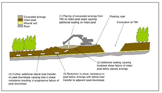
Schematic diagram from the 2020 EIA illustrating the mechanisms of the 2003 peatslide at Derrybrien in the Republic of Ireland.
.
So, it seems that the mechanism was that excavated material was emplaced on the peat adjacent to the hole. Peat is weak and has a very high water content. The emplaced material drove a localised shear failure, allowing a small landslide to develop. This then induced an additional load downslope, triggering the development of a much larger mass movement.
This appears to me to be a viable mechanism, but it also implies no retrogression occurred. This is intriguing as that was certainly not the case for the Meenbog peat landslide in November 2020. I am slightly fascinated by the hint of a failure on the upslope side of the excavation in the schematic diagram. I wonder why this was included.
It would be fascinating to see the geotechnical reports after the 2003 landslide. Does anyone know if these are available?
29 March 2022
Mount Talakmau: landslides from the 25 February 2022 Sumatra Earthquake
Mount Talakmau: landslides from the 25 February 2022 Sumatra Earthquake
On 25 February 2022 a M=6.1 earthquake struck West Sumatra in Indonesia at a depth of just 4.9 km. The epicentre of the earthquake was about 20 km from the peak of Mount Talakmau, a c.3,000 m elevation compound volcano thought to have been active in the Holocene.
In the aftermath of the earthquake, the ever impressive Sotoris Valkaniotis tweeted imagery of landslides triggered on the flanks of Mount Talakmau:-
And a 3D view of the debris flows & landslides on Mt Talakmau, using Sentinel-2 imagery. View towards south-southwest pic.twitter.com/MURG3Hu0Wj
— Sotiris Valkaniotis (@SotisValkan) March 5, 2022
.
Wow! Subsequently, UNOSAT has published a map of the landslides:-
https://twitter.com/UNOSAT/status/1501530107399352321
.
Their assessment is that the landslide area covered about 6 square kilometres. So, I have taken a look at the Planet imagery of the flanks of Mount Talakmau in the aftermath of the earthquake. The image below was collected on 26 March 2022:-
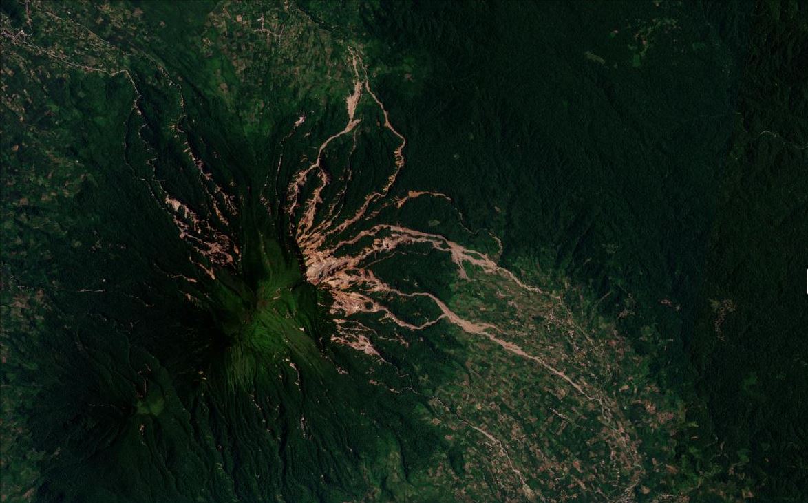
Satellite image of the landslides triggered by the 25 February 2022 Sumatra earthquake. Image copyright Planet Team, used with permission. Image collected on 26 March 2022.
.
Hopefully, you will be able to use a Juxtapose slider below to compare images from before and after the earthquake:-
.
There are many interesting aspects of these landslides. On the upper part of the slopes they appear to be very many shallow, disrupted failures in the volcanic soils. The vast majority have entered the drainage system, although there are also many isolated landslides too. The landslides appear to have transitioned to become channelised flows with a long runout, presumably driven by the steep topography and a large amount of entrainment. Some of the flows have travelled at least 10 km, with evidence of small amounts of material moving considerably further.
Interestingly, most of the landslides are on the east and northeast sides of Mount Talakmau, with a smaller but still significant cluster to the northwest. This could be a topographic effect, a directional effect associated with the seismic waves or simply a reflection of the fact that the epicentre was to the northeast of the volcano.
It is intriguing that an earthquake has triggered highly mobile, presumably saturated landslides. But this is a humid tropical environment and the soils are made from volcanic materials. Thus, it is likely that they had a high moisture content at the time of the earthquake, allowing some form of liquefaction to occur. These landslides might be described as lahars.
As an aside, there is no evidence of a valley-blocking event that I can see.
This is a fascinating event, worthy of much more detailed investigation. I hope that someone is able to undertake detailed mapping and analysis – it is certainly worthwhile.
.
Acknowledgement
Planet Team (2022). Planet Application Program Interface: In Space for Life on Earth. San Francisco, CA. https://www.planet.com/
28 March 2022
Ibri: a large quarry landslide in Al-Dhahirah, Oman
Ibri: a large quarry landslide in Al-Dhahirah, Oman
On 27 March 2022 a series of large quarry landslides occurred at Ibri in Al-Dhahirah governorate in Oman. This event was captured on a dramatic video posted to Youtube that I have tweeted to enable an embed here:-
Ibri quarry mishap: Death toll rises to 6 https://t.co/6Ord3huYrH via @YouTube
— Dave Petley (@davepetley) March 28, 2022
.
There are also videos showing later stages of the landslide sequence:-
.
The image below, from AP, shows one of the later slope collapses:-
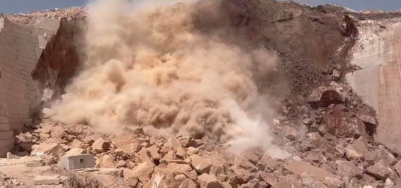
The 27 March 2022 quarry landslide at Ibri in Oman. Image from AP via the Daily Sabah.
.
Reports indicate that six people were killed in this landslide and that a further five were injured. The rescue and recovery operations were severely hampered by the ongoing rockslide activity. It is unclear as to whether all of the victims have been recovered.
Ibri is a centre for marble quarrying, which is consistent with the stepped structure of the rock mass seen on the left side of the image above.
The marble quarries of Oman are not without controversy. In 2015 the Gulf News reported that quarries in the Ibri area were owned by government minsters, with the products being exported, with low rates of tax being paid, for example.
Catastrophic failures in marble quarries are comparatively rare because the regular jointing can make prediction of the likelihood on instability easier when compared with other rock masses. However, in 2016 there was a fatal collapse of a marble quarry at Colonnata in Italy, where the famous Carrara marble was being extracted. In that case, two workers lost their lives.
22 March 2022
Scud Glacier: images of the 2020 rock avalanche in British Columbia
Scud Glacier: images of the 2020 rock avalanche in British Columbia
Loyal reader Brian Rottenfusser has very kindly sent me two images of a rock avalanche that occurred on the Scud Glacier near to Telegraph Creek in British Columbia in Canada. The images were taken by Bob MacDonald, who has given permission for me to publish them. The images were taken on 16 September 2020, although the landslide probably occurred some months earlier.
The first shows a rather beautiful rock avalanche deposit on the surface of the Scud Glacier:-
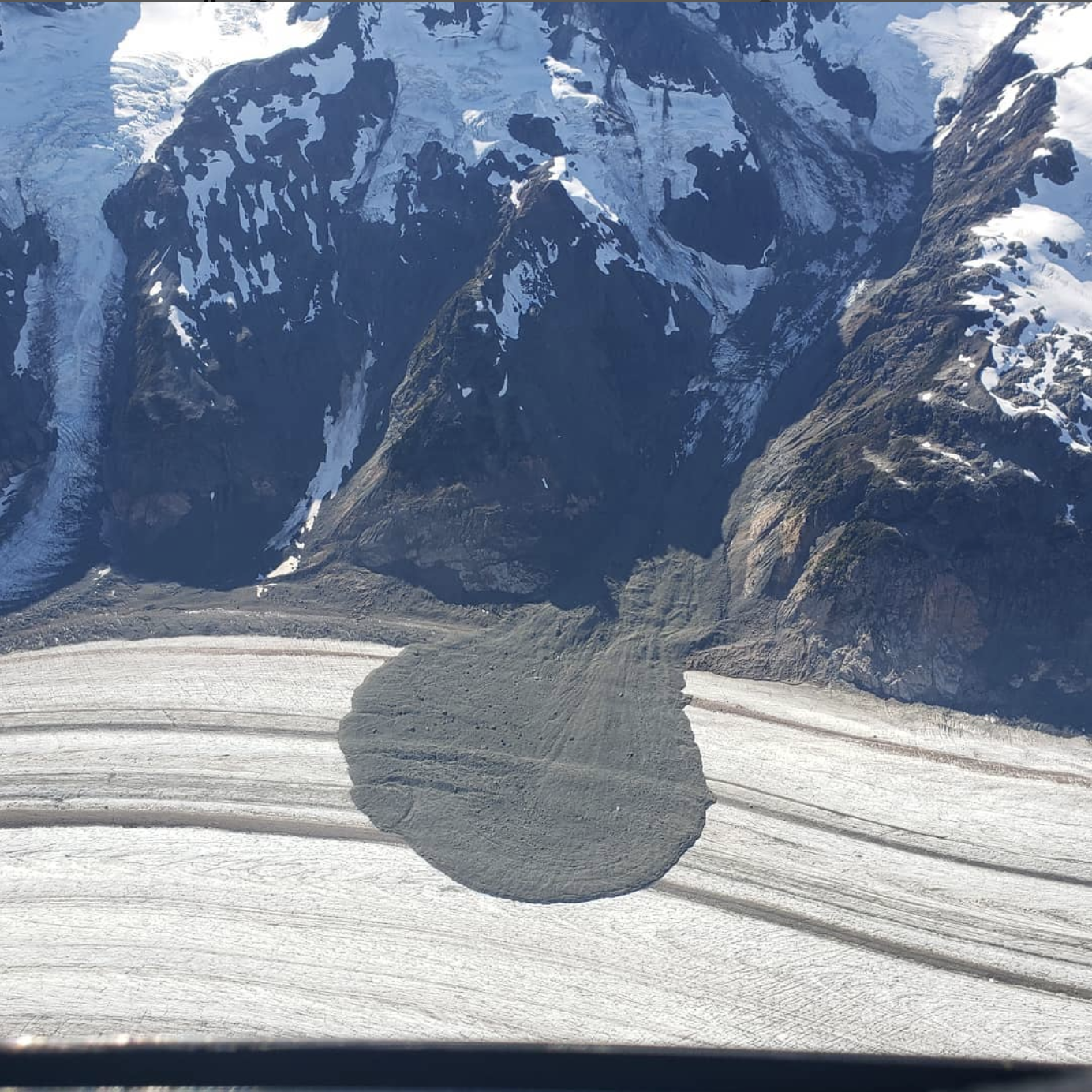
The 2020 rock avalanche onto the Scud Glacier in British Columbia. Image by Bob MacDonald, used with permission.
.
Note the symmetric shape of the deposit, with some enhanced mobility on the debris bands (this might be topographically driven). The track of the rock avalanche is visible down the gully.
The second image provides a perspective view from a greater distance:-
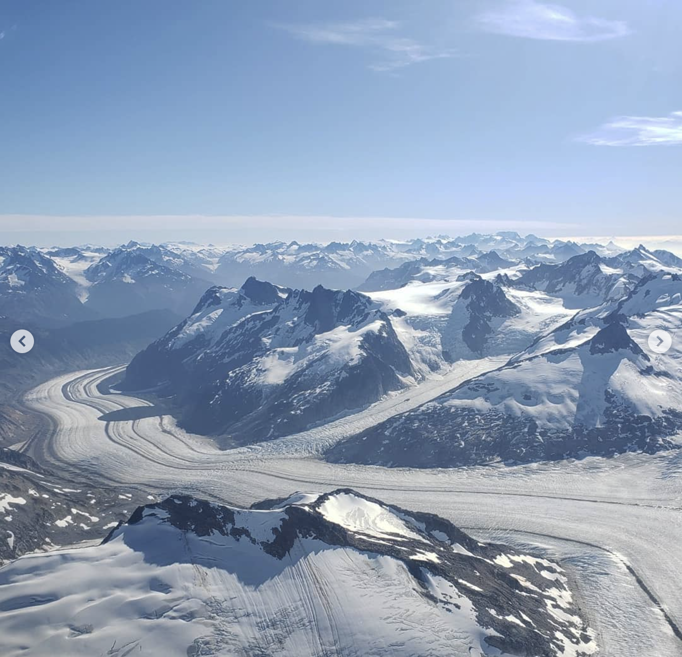
A more distant view of the 2020 rock avalanche onto the Scud Glacier in British Columbia. Image by Bob MacDonald, used with permission.
.
Whilst I haven’t heard much about this event, Alexandre Bevington tweeted some satellite images of it in June of last year.
16 March 2022
Retamas: a fatal landslide caught on video in Peru
Retamas: a fatal landslide caught on video in Peru
On 15 March 2022 a large landslide occurred in the town of Retamas in La Libertad region of Peru. This landslide was captured on at least two horrifying videos. The first was captured from the other side of the valley, showing the main part of the failure engulfing a series of houses built below the main slope that failed. This video was tweeted by @EQuake_Analysis:
https://twitter.com/EQuake_Analysis/status/1503856014474588161
.
A second video was tweeted by @ysuradiocadena, taken from the same side of the valley. Again, the impact of landslide on the houses below is horrifying:-
#UltimoMinuto #EnDesarrollo Mas de 70 viviendas sepultadas tras deslizamiento de tierra en zonas de Retamas, Parcoy, #Perú. Se estiman 80 personas desaparecidas. (15.03.2022). #NoticiasYSU pic.twitter.com/x8YjiwGZ54
— YSUradiocadena (@ysuradiocadena) March 15, 2022
.
The aftermath of the landslide is captured in this Reuters image:-
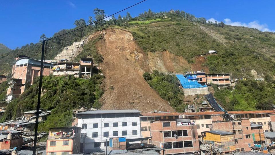
The aftermath of the 15 March 2022 landslide at Retamas in La Libertad, Peru. Image by Reuters.
.
The landslide has come after a period of heavy rainfall, although the conditions at the time of the landslide appear to have been dry. Reports indicate that 60 to 80 homes were buried (this looks surprisingly high to me). Apparently 15 people were initially trapped in the landslide, although many have been rescued. There are some indications that six people remain missing, including three children, although this will become more clear in the next day or so.
The precise location of this landslide is not yet clear to me- I suspect that is is -8.0233, -77..4760, but this is unconfirmed. This is a Google Earth image of Retamas, collected in August 2020:-
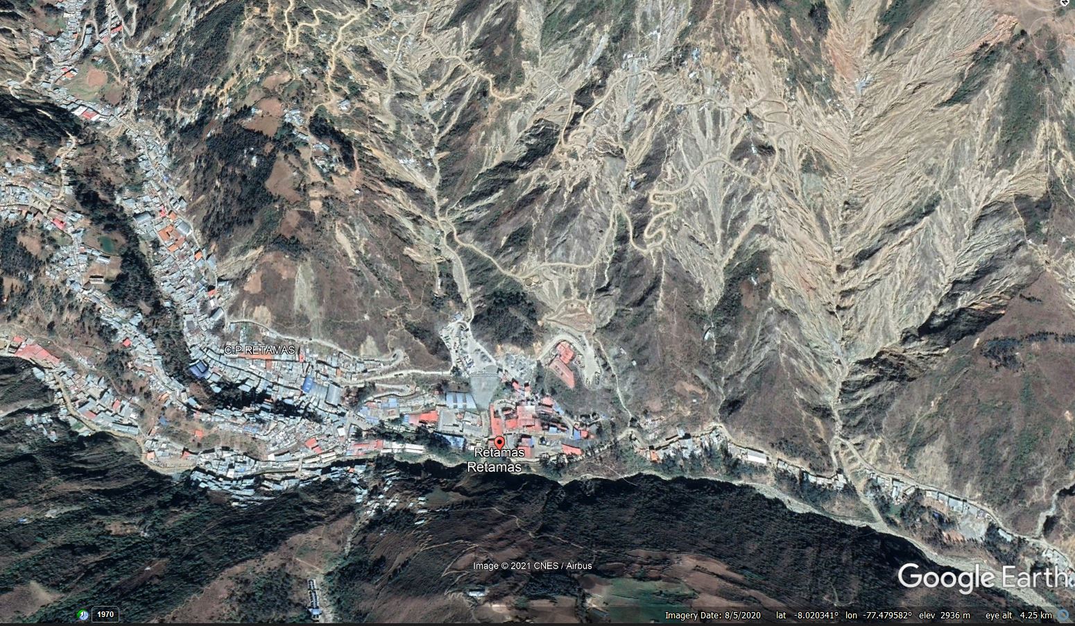
Google Earth image of the town of Retamas in Peru. Image collected in August 2020.
.
The stand out feature of this image is that this is an area that is dreadfully impacted by landslides. This is an area that is heavily affected by mining, including one of the largest gold mines in Peru. There is also a large amount of informal mining, which might explain the environmental damage seen in the images. These informal mines are reported to employ up to 5,000 miners.
 Dave Petley is the Vice-Chancellor of the University of Hull in the United Kingdom. His blog provides commentary and analysis of landslide events occurring worldwide, including the landslides themselves, latest research, and conferences and meetings.
Recent Comments