
9 May 2022
The Lowell Point landslide in Alaska
The Lowell Point landslide in Alaska
On Saturday 7 May 2022 a substantial landslide occurred near to Lowell Point, in the Seward area of Alaska in the USA. The landslide has blocked the only road into the community.
Must Read Alaska has a great aerial image of the landslide, taken by Chip Arnold:-
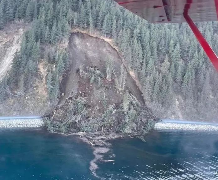
The Lowell Point landslide close to Seward in Alaska, USA. Image by Chip Arnold, via Must Read Alaska.
.
The landslide, which is located at about 60.093, -149.445, is estimated to be about 60 metres high and 90 m wide. As of Sunday, the landslide was still considered to be potentially unstable, impeding clearance operations.
There are at least three good videos of the landslide, one from each side. The start of this video shows the landslide from one side – note the attempts to clear the road before the main failure:-
.
Whilst the other has a slightly better perspective from the other side:-
.
The image below was taken by local landslide-watcher Harold Faust:-
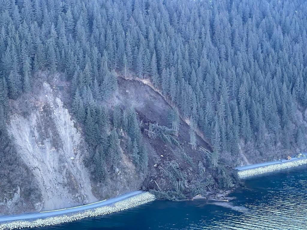
The Lowell Point landslide close to Seward in Alaska, USA. Image by Harold Faust.
.
Note the landslide scar to the left of Sunday’s failure. This event reportedly occurred a few years ago.
.
Acknowledgement
Thanks to loyal reader Hig, who highlighted the event to me and identified the correct location. He also passed on the image from Harold Faust.
5 May 2022
Malvik: an interesting landslide on the E6 highway in Norway
Malvik: an interesting landslide on the E6 highway in Norway
On Wednesday 4 May 2022 an interesting landslide occurred on the E6 highway near to Malvik in Norway. The site of the landslide appears to be 63.403, 10.804. The best image that I have found of the landslide has been posted on the nettavisen.no site:-
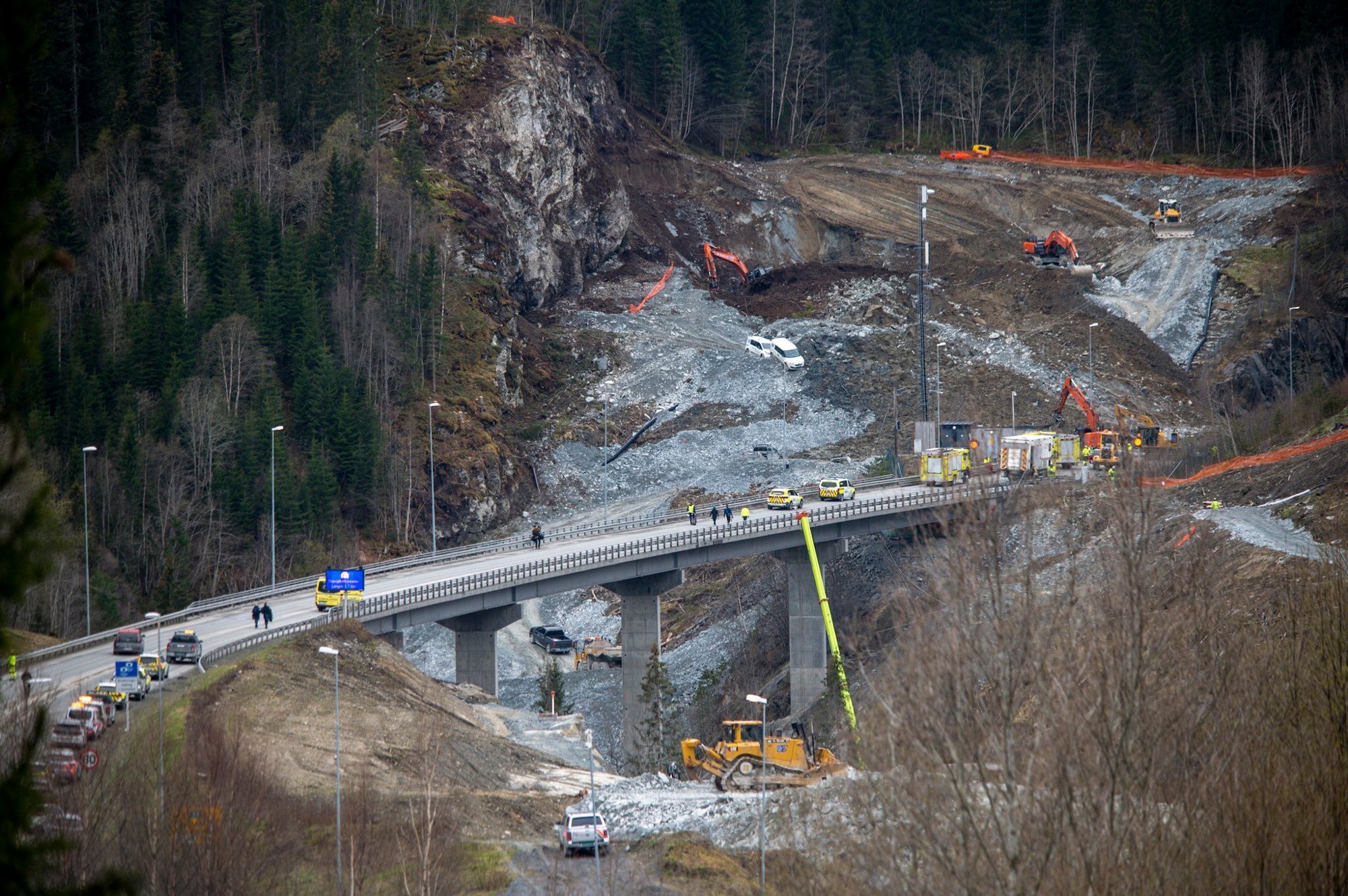
The aftermath of the landslide at Malvik in Norway on 4 May 2022. Image posted on the nettavisen.no website, by NTB scanpix.
.
One person was caught up in the landslide. Fortunately he was recovered from the landslide in a conscious condition. An image from tv2 shows the impact of the landslide on the road:-
The aftermath of the 4 May 2022 landslide at Malvik in Norway. Image from Frank Lervik / TV 2.
.
As per the comments below, there is also a Google Streetview of the site: https://goo.gl/maps/x1TmWHaaTZj6Msi98
It is probably very fortunate that there were not more casualties from this serious incident, given that it occurred at about 1 pm local time.
It is clear from the images that the landslide occurred at a site of ongoing groundworks, and indeed the injured individual worked for a subcontractor at the site. Note the backhoe located immediately below the back scarp of the landslide, heavily tilted, suggesting a rotational failure that has transitioned into an earthflow.
In the aftermath of the landslide 100 local residents were evacuated from areas around the site, but they have now been allowed to return home. The E6 road is now closed.
The online newspaper nrk.no reports that this stretch of road has ongoing works for the construction of a new motorway. The most recent Google Earth image of the site, from September 2018, shows that the site was forested.
4 May 2022
The Claxton Bay landslide in Trinidad
The Claxton Bay landslide in Trinidad
The residents of a community in Belle View in the Claxton Bay area of Trinidad in the Caribbean are having their lives destroyed by a landslide. The failure started to damage the houses in September 2021; to date six houses have been affected. Last week the residents received a letter from the owners of a quarry downslope from the site, informing them that their houses are likely to suffer further damage in the rainy season.
This image, from the Trinidad Guardian, shows the scale of the problem:-
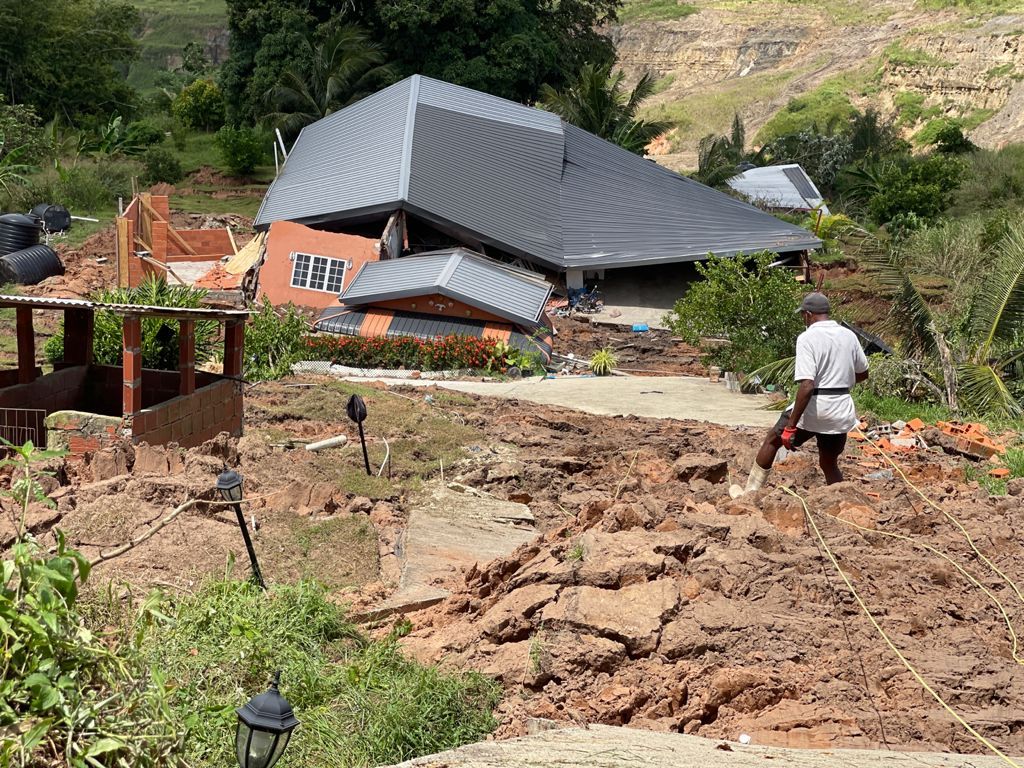
Landslide damage from the landslide at Claxton Bay in Trinidad. Image by Ivan Toolsie via the Trinidad Guardian.
.
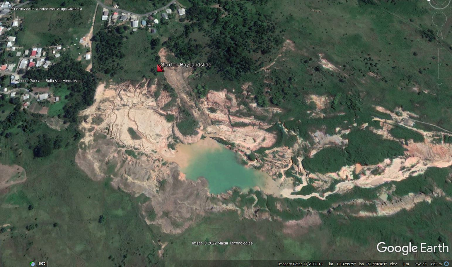
I believe that the location of the landslide is 10.381°, -61.445°. This is a Google Earth image of the site, dated May 2021:-
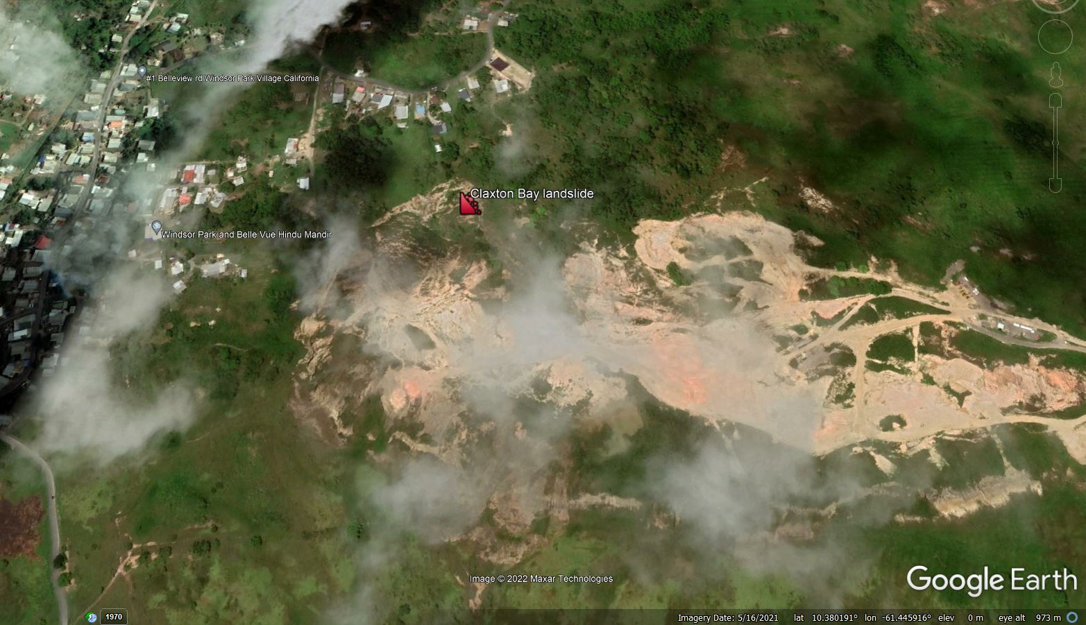
Google Earth image of the site of the Claxton Bay landslide in Trinidad, collected in May 2021, before the landslide retrogressed to affect the houses.
.
The key features here are the quarry on the downslope side, the clear active landslide beneath the marker, and the houses at the top of the slope (top of the image). This image was collected before the landslide retrogressed to affect the houses.
The historical image set for this site is really interesting and very informative. An image from February 2015 shows active quarrying at the site, and the creation of a steep slope on the quarry face:-
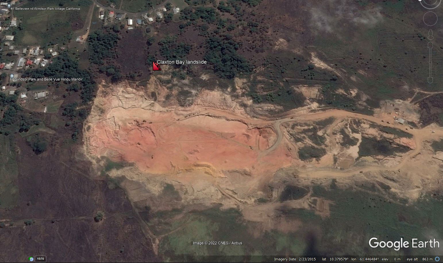
Google Earth image of the site of the Claxton Bay landslide in Trinidad, collected in February 2015, before the landslide retrogressed to affect the houses.
.
By January 2016 the situation had changed considerably. The intensity of quarry activity appears to have been lower, but a landslide had started to develop in the wall of the quarry, immediately to the right of the marker in the image. Two clear lobes had developed, one of which had impinged significantly into the workings. Land was being lost from below the houses:-
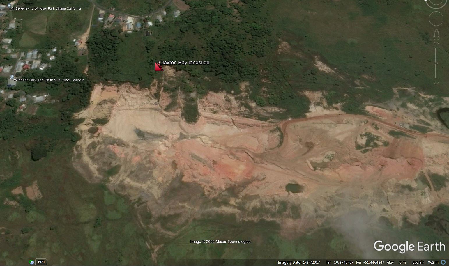
Google Earth image of the site of the Claxton Bay landslide in Trinidad, collected in January 2017, before the landslide retrogressed to affect the houses.
.
By November 2018 the landslide had developed very significantly. The head scarp of the main failure had retrogressed by about 100 metres, the landslide had widened and the lobes had extended much further into the quarry:-
Google Earth image of the site of the Claxton Bay landslide in Trinidad, collected in November 2018, before the landslide retrogressed to affect the houses.
.
It also appears that the remaining unfailed portion of the slope was degrading rapidly.
The image in May 2021, although partially affected by cloud, shows that a much larger failure had developed. This is zoomed in view from that time:-
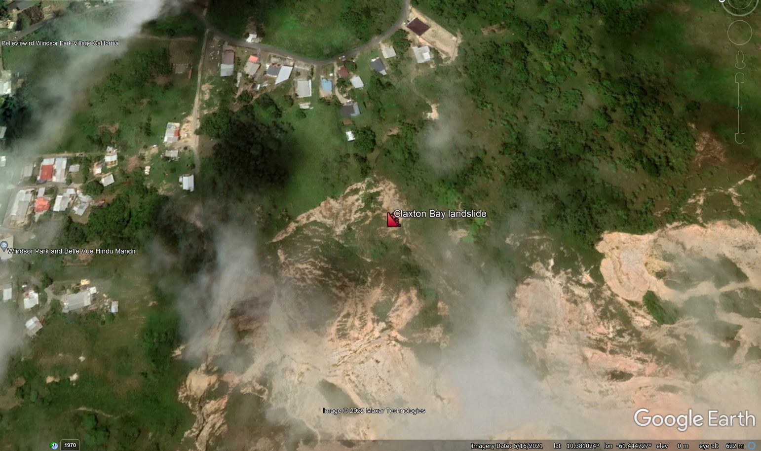
Zoomed in Google Earth image of the site of the Claxton Bay landslide in Trinidad, collected in May 2021.
.
It is not difficult to see how a further episode of retrogression has directly impacted the houses.
It is interesting to note that the letter from the owner of the quarry is explicit that it does not accept liability for the landslide. Readers will be able to come to their own conclusions as to whether this is a reasonable position.
3 May 2022
The Pilar landslide in the Philippines
The Pilar landslide in the Philippines
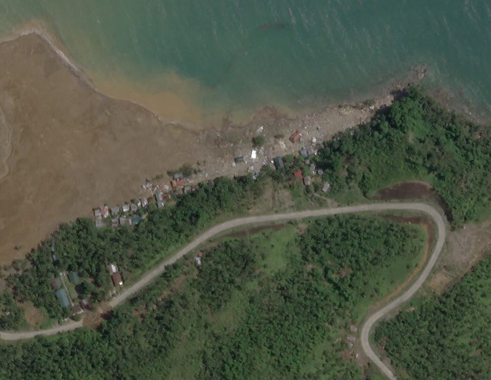
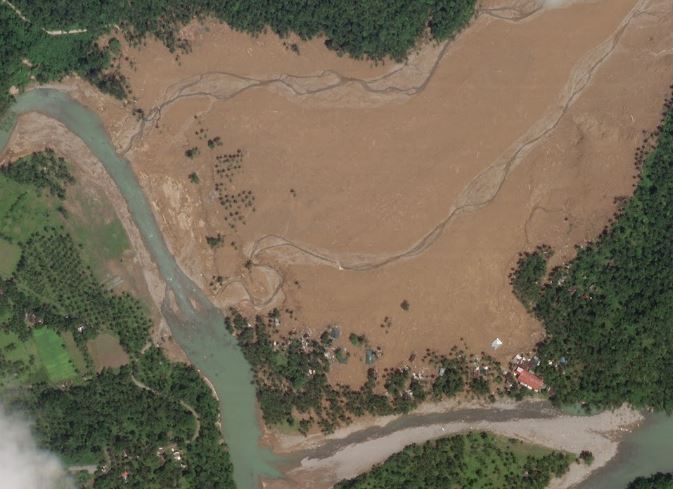
One of the largest landslides triggered by Tropical Storm Megi last month occurred at Pilar, a little to the southeast of the town of Abuyong in Leyte. This location, which is also known as Dang’s Beach Resort, suffered from one of the three very large landslides during the storm. It is located at 10.717, 125.040. The latest NDRRMC situation report lists 53 known fatalities at this site.
Planet has succeeded in collecting a high resolution satellite image of the landslide at Pilar:-
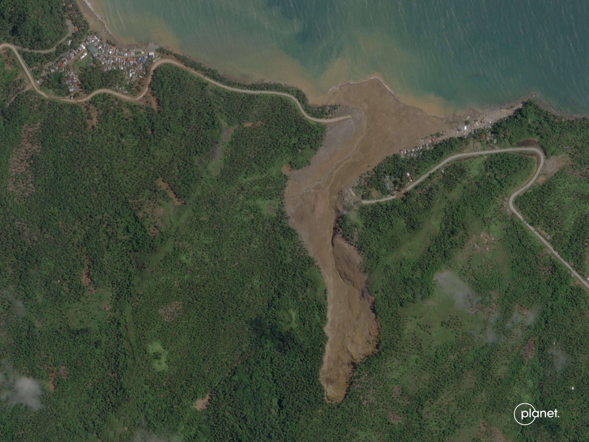
The Pilar landslide in the Philippines. Image copyright Planet, used with permission. Image dated 20 April 2022.
.
By way of comparison, this is a Google Earth image of the same area, collected in June 2016:-
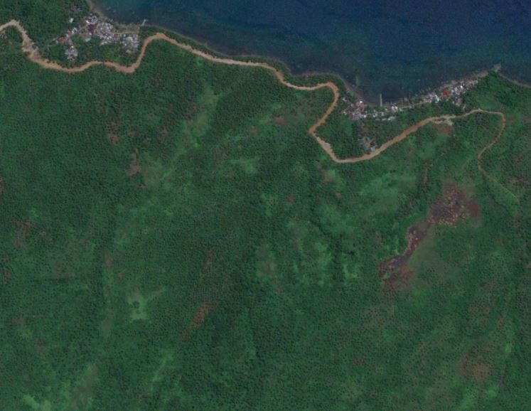
Google Earth image from June 2016 showing the site of the Pilar landslide in the Philippines.
.
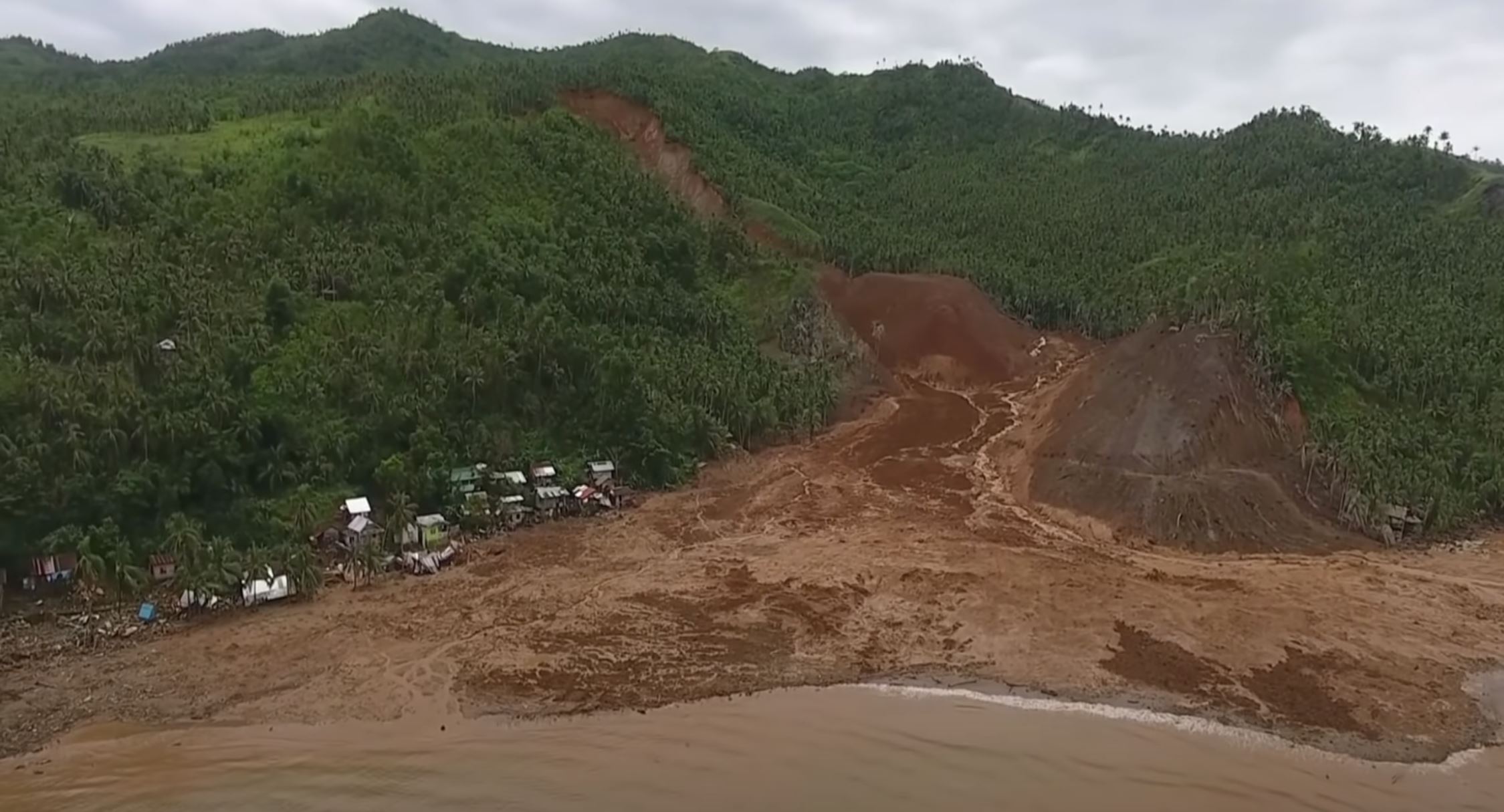
A particularly interesting aspect of this landslide is that it clearly generated destructive displacement waves when it reached the sea. The damage to the main part of the seaside resort appears to be consistent with damage caused by these waves:-
Damage caused by the Pilar landslide in the Philippines. Much of this appears to be consistent with the impact of a displacement wave. Image copyright Planet, used with permission. Image dated 20 April 2022.
.
There is a paper in the Annals of Tropical Research (Cabelin and Jadina 2019) that analyses of the soils in landslide areas in the Cadac-an Watershed, which includes the site of this landslide. It notes that:
“…it was concluded that the soils are susceptible to landslide occurrence.
“It is highly recommended to conduct constant assessment and monitoring of landslide occurrences in the area. Moreover, it is encouraged to plant more trees, prohibit tree cutting, delineate danger zone , establish more rain gauge stations and provide early warning systems to somehow prepare for the consequences brought about by landslides.”
It is hard to disagree.
.
References and acknowledgement
Planet Team (2022). Planet Application Program Interface: In Space for Life on Earth. San Francisco, CA. https://www.planet.com/
Cabelin, J.P. and Jadina, B.C. 2019. Physical characteristics of soils in landslide areas of Cadac-an Watershed in Leyte, Philippines. Annals of Tropical Research 41 (2) 11-129.
Thanks to Robert Simmon and Anne Pelligrino for their support in acquiring the image.
22 April 2022
Understanding the deadly landslides in the Durban area of South Africa
Understanding the deadly landslides in the Durban area of South Africa
In the last week I have posted extensively about the deadly landslides on 11 April 2022 in the Philippines. At around the same time an event of a similar scale occurred in a completely different location. It is reasonable to ask why I have not written about that one.
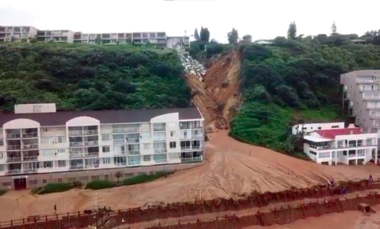
The event in question occurred in the Durban area of South Africa. Once again it was triggered by heavy rainfall. Reliefweb posted an update on this event yesterday – the statistics are appalling:
According to national authorities, 443 people died in KwaZulu-Natal and over 40,000 are missing. More than 40,000 people have been displaced, while nearly 4,000 houses were destroyed and more than 8,000 others were damaged, mostly across Durban City and its surrounding areas. A National State of Disaster has been declared in response to the floods and landslides, and rescue teams have been deployed to the affected areas to provide humanitarian assistance to those most affected.
Hopefully the number missing is primarily the result of challenges of documenting displaced people, but even if the death toll remains at its current level, the picture is truly grim.
The challenge that I have had with this event has been obtaining reliable information about what has actually happened. It is not at all clear to me as to why this is the case. However, The Conversation has now published an article by Stellenbosch University, who provides a readily understandable explanation for the underlying causes of the landslides in this area. It is worth a read – the underlying problems are weak geology.
In the coastal region, the problems are associated with a large, vegetated dune formation that is prone to rapid erosion:
Ground adjacent to the sea from Durban to Mtunzini (a coastal town 140km north of Durban) is almost exclusively made up of ancient red sand dunes termed the Berea formation. South of the Durban harbour these sands form a ridge called the Bluff and north of the harbour they form the Berea Ridge. In some places these sand dunes are extremely steep…The investigation showed the slopes’ stability was not significantly affected by rainfall. That makes sense as these slopes have been battered by storms over geological time. But concentrated flows from poorly controlled flood water or broken water pipes were found to be catastrophic.
This is dramatically illustrated at the town of Umdloti:-
Highly destructive gully formation at Umdloti, near to Durban in South Africa. Image from the North Coast Courier.
.
Meanwhile, inland the geology also causes problems. Part of the area is underlain by the shales of the Pietermaritzburg formation, which consist of thin layers of clay and silt. These shales weather easily and trap high pore water pressures, making them very susceptible to failure. Other parts of the region are underlain by sandstones of the Natal group, which also contain layers of clay that trap high pore water pressures.
Understanding the distribution of these landslides, and the associated floods, is going to be a challenge but is urgently needed. Meanwhile, the best pictoral record I can find has been posted to Facebook by Kierran Allen Photography. This is an example of one of their images:-
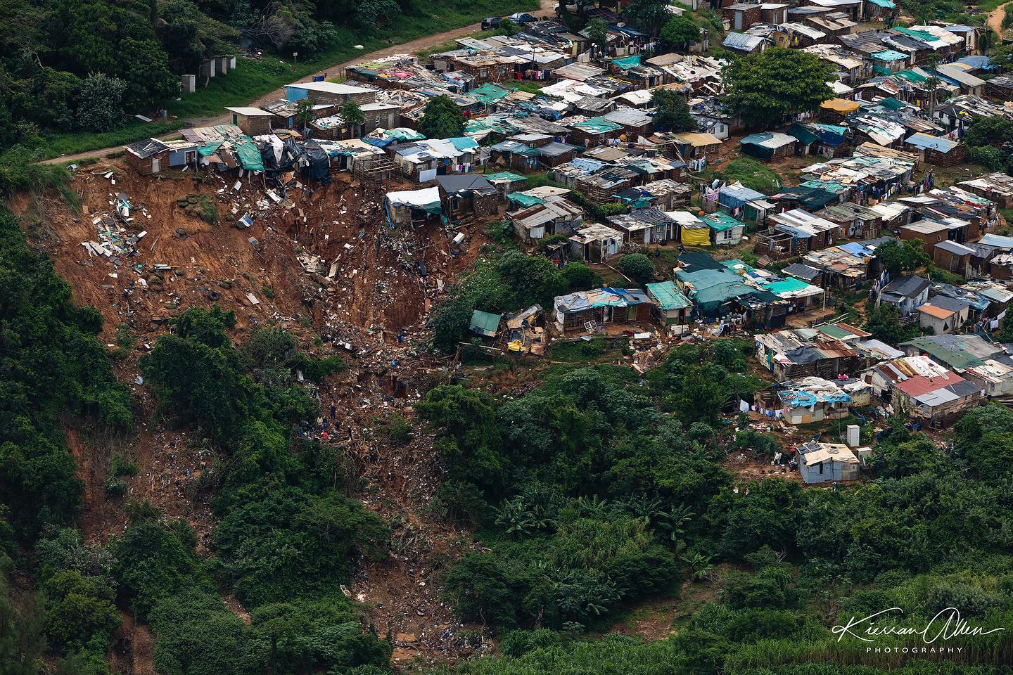
A landslide in the Durban area of South Africa, triggered by the April 2022 rainfall event. Image by Kierran Allen Photography.
.
The devastating impact of such a landslide, even though it is small, is clear to see.
21 April 2022
Wairoa: hundreds of landslides triggered by heavy rainfall in New Zealand
Wairoa: hundreds of landslides triggered by heavy rainfall in New Zealand
The last few weeks have seen high levels of rainfall in the Wairoa area of New Zealand. Most notably, in late march a series of major rain events triggered multiple landslides in this important agricultural area within Hawke’s Bay. RNZ has an excellent report on the situation as per late March, noting that:-
A Wairoa farming leader says the relentless rain still falling in northern Hawke’s Bay is like a recurring nightmare and farmers are beside themselves. Federated Farmers Wairoa branch chair Allan Newton said conditions were now 10 times worse than after last week’s deluge. Consistent rain meant the soil could not soak up any more water and the ground had turned liquid, he said.
The RNZ report includes a couple of images of examples of the landslides, including this one:-
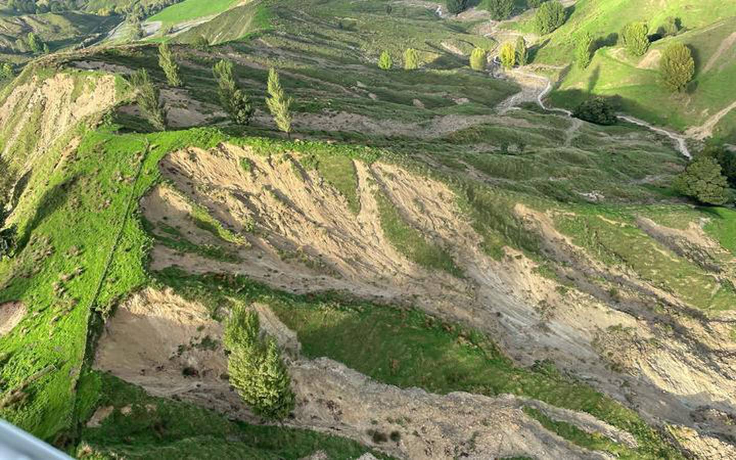
Landslides in the Wairoa area of New Zealand. Image by Wairoa Helicopters via RNZ.
.
These landslides are visible even in the daily imagery collected by Planet. For example, this is an area affected by these failures (the image is in the area of 38.827, 177.618):-
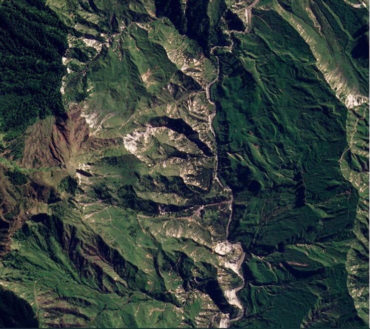
Satellite imagery showing some of the new landslides in the Wairoa area of New Zealand. Image copyright Planet, used with permission. Image dated 10 April 2022.
.
As a comparison, this is the same area on 1 February 2022:-
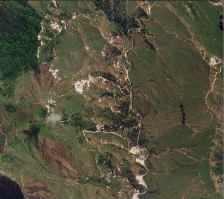
Satellite imagery showing the area affected by landslides in the Wairoa area of New Zealand. Image copyright Planet, used with permission. Image dated 1 February 2022.
.
Below you should be able to see a slider allowing comparison of the before and after imagery:-
.
As the original image shows, this is an area that is heavily affected by landslides even before this year, but these rainfall events have triggered multiple shallow slips. It is notable that these are located primarily in the deforested grassland areas – there is little evidence of new failures in areas of woodland – and there appears to be a strong control by slope aspect (I see fewer slips on the westward facing slopes).
These shallow landslides affect an area that is much larger than I have shown in the images.
The slips will likely cause short and medium term challenges for the farmers, who have lost valuable grazing land, and the sediment into the channels will also have downstream impacts. The sediment in the river is clear in the photograph at the top of this piece.
.
Acknowledgement
Planet Team (2022). Planet Application Program Interface: In Space for Life on Earth. San Francisco, CA. https://www.planet.com/
20 April 2022
UNOSAT analysis of the Leyte landslides from Tropical Storm Megi
UNOSAT analysis of the Leyte landslides from Tropical Storm Megi
The United Nations Institute for Training and Research (UNITAR) has published an initial satellite image analysis undertaken by the United Nations Satellite Centre (UNOSAT) of the landslides and flooding caused by Tropical Storm Megi in Leyte in the Philippines. This is based on 50 cm resolution Pleiades imagery acquired on 14, 16 and 17 April. The analysis is available to download.
Included in the analysis is imagery of some of the large landslides. One image shows the landslide at Bunga village, using an images dated 14 April 2022:-
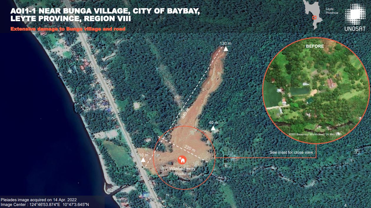
UNOSAT analysis of a Pleiades image of the landslide at Bunga village in Leyte.
.
The track length of this landslide is about 600 m, so it is a large failure. This has probably initiated as a shallow failure high on the hillside that entrained a large volume of material from the slope. It is interesting that the landslide appears to have initiated on a forested hillslope. The UNOSAT analysis suggests that 20 structures were destroyed or seriously damaged.
A second example is the Kantagnos village landslide, which I featured yesterday. The UNOSAT Pleiades image has captured the source area of the landslide:-
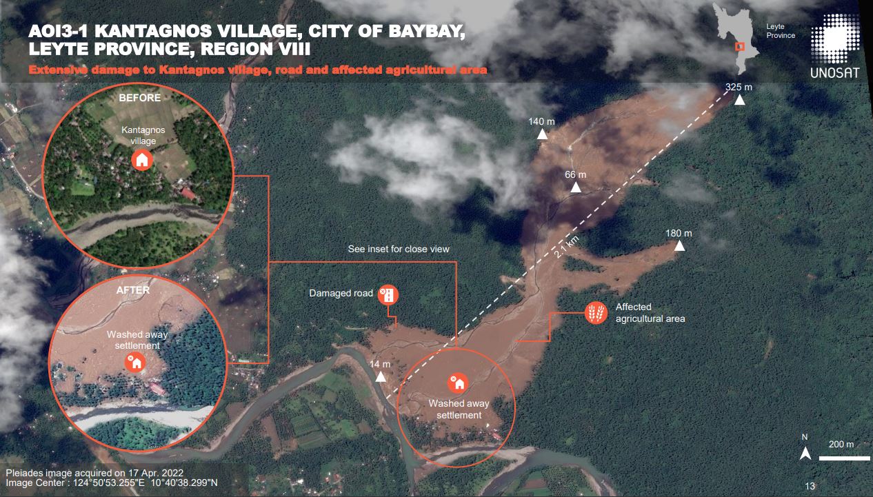
UNOSAT analysis of a Pleiades image of the landslide at Kantagnos village in Leyte.
.
With a track length of about 3 km, this is a very large failure. The width of the source area is a surprise to me – this is a landslide that needs a much more detailed investigation. I wonder to what degree it would have been possible to anticipate a failure of this scale at this location. The before and after comparison in the imagery is quite sobering:-
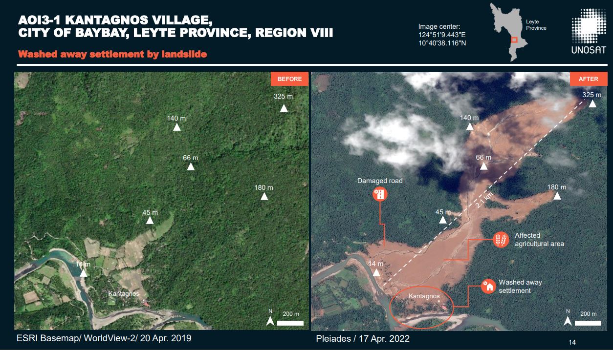
Before and after UNOSAT analysis of Worldview and Pleiades imagery of the landslide at Kantagnos village in Leyte.
.
Mapping of existing and potential landslides requires 3D imagery, but dangerous sites are often evident even in 2D images. But in the case of the Kantagnos landslide I would have struggled to identify this as a dangerous site on first inspection of the morphology of the slopes. The elements that might have made me suspicious are the areas that had been deforested for agriculture (and old landslide surface?) and, more importantly, those large, 90 degree bends in the river (has it been displaced by a landslide deposit?).
At Kantagnos, UNOSAT reports that 83 structures were destroyed or heavily damaged. The location has been declared to be uninhabitable. Inquirer.net reports that the latest information is that 59 people were killed at this site, and at least 63 remain missing.
The total toll from Tropical Storm Megi is now estimated to be 175 people, with a further 110 missing. Recovery operations have been terminated at most locations.
19 April 2022
Planet image of the Kantagnos village landslide in the Philippines
Planet image of the Kantagnos village landslide in the Philippines
My friends at Planet have very kindly acquired a high resolution satellite image of the Kantagnos landslide in the Philippines, which occurred during Tropical Storm Megi / Agaton on 11 April 2022. This image, which shows most of the the landslide, was captured on 17 April 2022 at 22:15 UT. This is the image:-
High resolution satellite image of the Kantagnos village landslide in the Philippines. Image copyright Planet, used with permission.
.
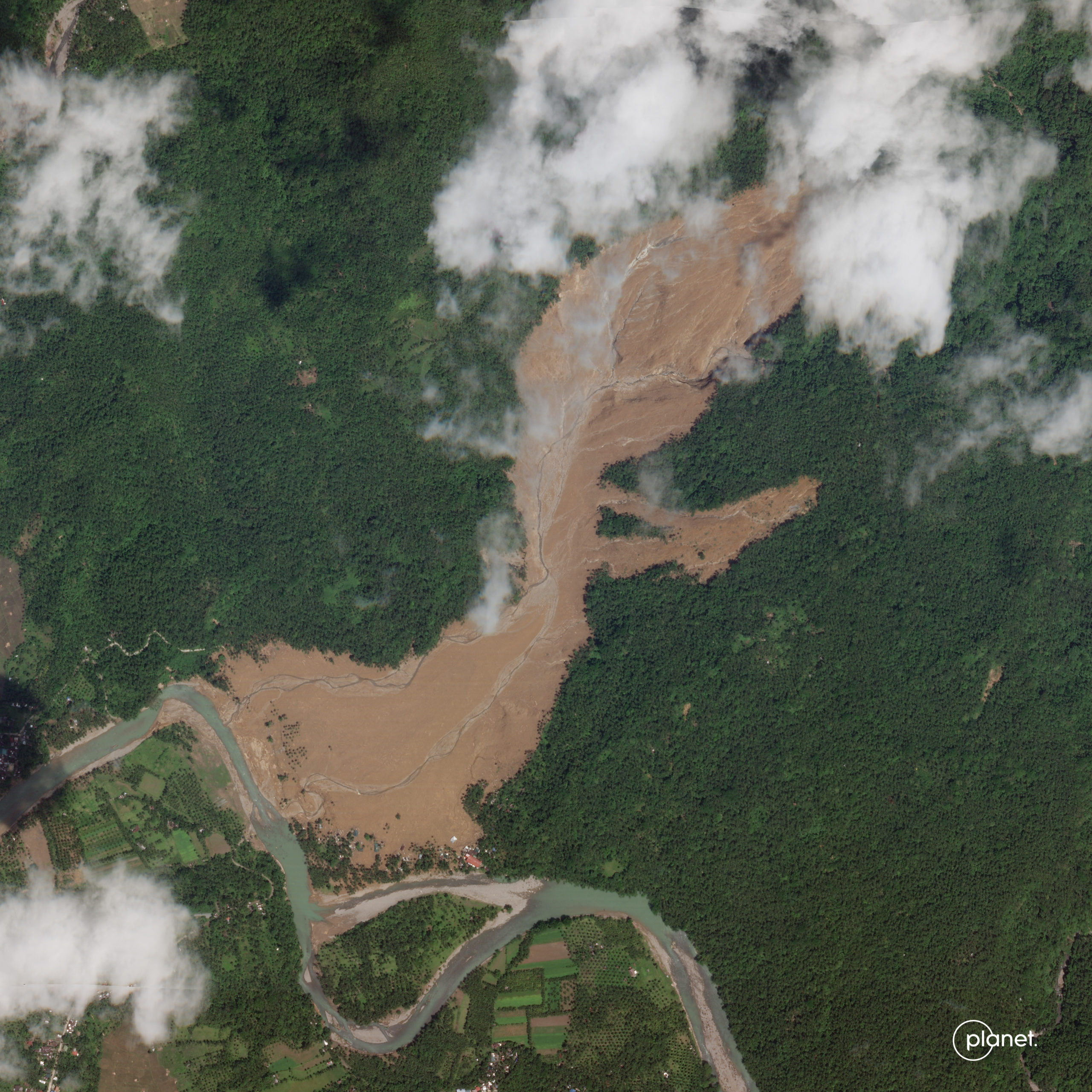
The main source of the landslide is in the cloud to the northeast of the image. As I noted previously, there is another substantial source that is visible. The flow has passed through a comparatively narrow gap and then spread. Note that there is very little evidence of landslide debris, implying a very mobile, fluid flow that has been removed by the river, which of course would have been in flood at the time of the failure.
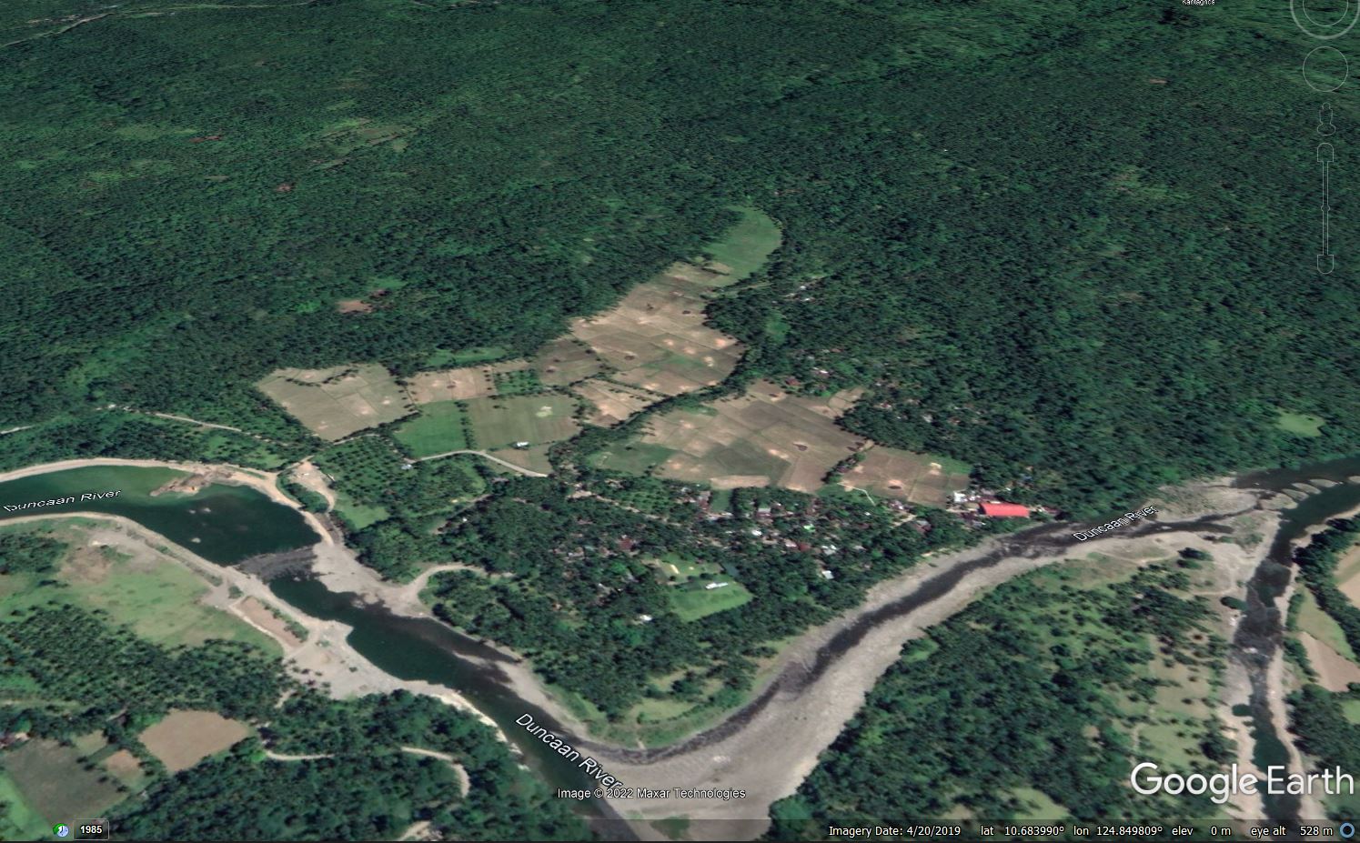
For comparison, this is a Google Earth image of the same site ( I have included the location for reference), dated 20 April 2019:-
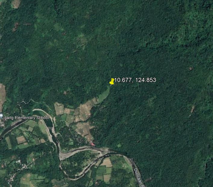
Google Earth image of the site of the Kantagnos village landslide in the Philippines.
.
The latest NDRRMC report lists 50 known fatalities at Kantagnos, with 93 people listed as missing. The total death toll from Tropical Storm Megi is now 175 people, with a further 110 people missing. The vast majority of the deaths occurred in landslides. Remarkably, an 11 year old boy survived the Kantagnos village in a refrigerator, but tragically his parents and a sibling were killed.
The impact of the landslide can be made clear by examining the inhabited area near to the river. This is the site in 2019:-
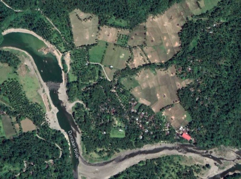
Google Earth image of the toe of the site of the Kantagnos village landslide in the Philippines.
.
And this is the site from the Planet image:-
High resolution satellite image of the Kantagnos village landslide in the Philippines. Image copyright Planet, used with permission.
.
Hope fully, below you will see a slide comparison of the two images:-
.
It is clear that multiple houses have been destroyed in the landslide, as well as a substantial area of agricultural land.
.
Acknowledgement
Planet Team (2022). Planet Application Program Interface: In Space for Life on Earth. San Francisco, CA. https://www.planet.com/
Many thanks in particular to Rob Simmon of Planet for providing the image. Simply amazing.
14 April 2022
Three very large landslides triggered by Tropical Storm Megi / Agaton
Three very large landslides triggered by Tropical Storm Megi / Agaton
Over the last two days more information has started to emerge about the landslides triggered by Tropical Storm Megi / Agaton, which caused mayhem on the island of Leyte in the Philippines on 11 April 2022. The latest news on casualties is that at least 123 people were killed, the majority in landslides, but more remain missing.
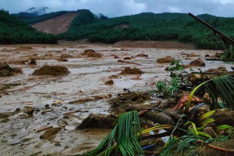
Earlier this week I highlighted a major landslide at the village of Kantagnos in Baybay. The Inquirer has now published an image that provides a detailed view of this site:-
The aftermath of the landslide at Kantagnos village in Baybay City, Leyte, Philippines, triggered by Tropical Storm Megi. Image from Inquirer.net.
.
This is a very large failure in deeply weathered materials. The source appears to be a shallow slide on a steep, forested hillslope, but note that there are at least two other sources, albeit substantially smaller. The landslide has spread considerably to affect a very large swathe of land. The small number of standing trees might suggest that it was a comparatively shallow flow, but to a human or a weak structure it would have been devastating. Note the houses on the margin of the landslide on the right side of the image.
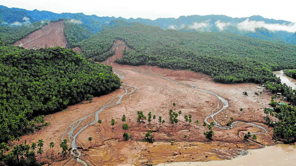
A second major event occurred in the village of Pilar in Abuyog. Here at least 29 people are known to have died, but as many as 177 more are reported to be missing. This total is likely to reduce, but it is clear that the landslide here has been devastating.
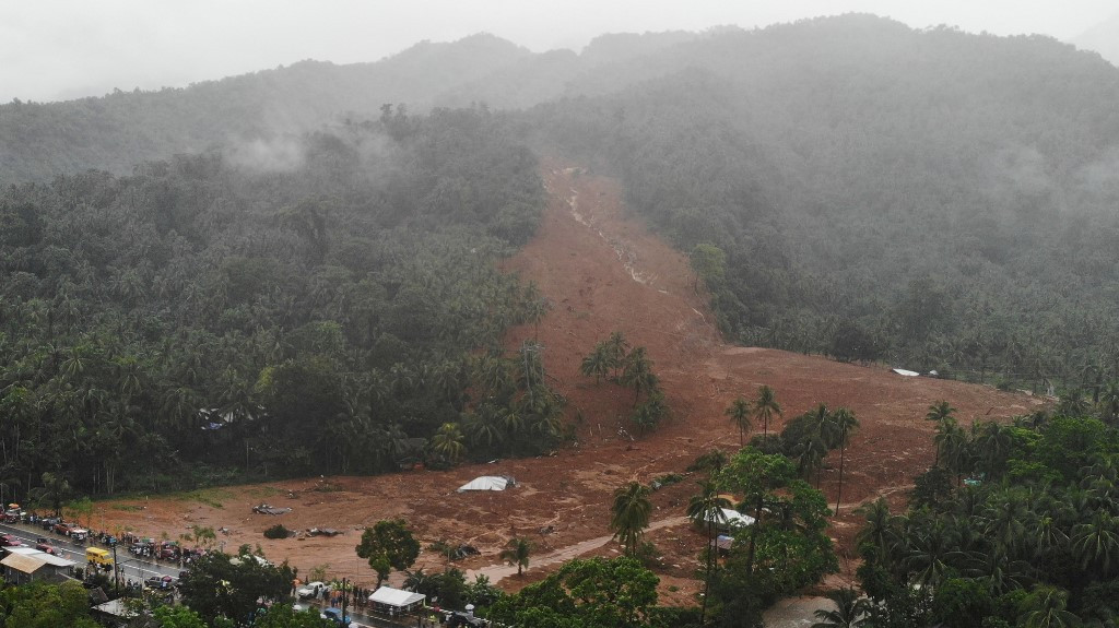
I can find few images of this landslide online, but Youtube has a drone video of the site:-
.
I have taken this image from the video, providing a decent impression of the failure:-
The devastating landslide at Pilar, triggered by Tropical Storm Megi. Image from Youtube drone video.
.
This appears to be a deeper seated landslide that has transitioned into a flow. Note the stripping of the vegetation on the slope on the right side of the image, which suggests to me that this was a high runout speed event. I also wonder if this event generated a displacement wave.
There are some videos online of secondary failures at this site, such as this one:-
.
The power of even this smaller landslide is appalling.
A third example occurred at the village of Bunga, also in Baybay. This landslide was also fatal – at least 17 people were killed here. The Jakarta Post has an image of this landslide:-
The landslide at Bunga in Leyte, triggered by Tropical Storm Megi. Image from AFP/Bobbie Alota via the Jakarta Post.
This landslide is broadly similar to the one at Kantagnos, although on a smaller scale.
I have been trying to track down the locations of these three landslides. At the moment, I believe that the following at correct:
Kantagnos in Baybay: 10.677, 124.853
Pilar in Abuyog: 10.714, 125.048
Bunga in Baybay: 10.773, 124.785
The impact of these landslides, and there are reports of many other events as well, is very serious. Tropical cuclones often cause landslides in the Philippines, but not in April.
12 April 2022
Landslides from Tropical Depression Agaton (Megi) in the Philippines
Landslides from Tropical Depression Agaton (Megi) in the Philippines
On Sunday 10 April 2022 Tropical Depression Agaton (known as Tropical Depression / Storm Megi internationally) tracked across Leyte in the Philippines, bringing torrential rainfall. Reports indicate that there have been multiple landslides causing widespread damage. The most damaging landslides appear to have occurred in the Baybay City region, where at least 22 people have been killed in multiple slides. Further people are missing.
Another very significant landslide has occurred at Kantagnos village in Baybay City. The Philipppines News Agency has this image of the downstream impact of this landslide, which is reported to have killed at least three people:-
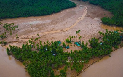
The aftermath of the landslide at Kantagnos village in Baybay City, Leyte, Philippines, Tropical Depression Agaton. Image by Pobreng Biyahero via Philippine News Agency.
.
Al Jazeera has this image of what is I think the same site, showing a very large landslide scar:-
The aftermath of a landslide, possibly at Kantagnos village in Baybay City, Leyte, Philippines, triggered by Tropical Depression Agaton. Image from Al Jazeera.
.
The location of this landslide appears to be 10.677, 124.853. This is a perspective view on Google Earth:-
Google Earth perspective view of the likely site of the landslide at Kantagnos village in Baybay City, Leyte, Philippines, Tropical Depression Agaton.
.
This appears to be a very large failure and flow. There are images online of other large events, and one Youtube video of a substantial failure, but at the moment I am struggling to determine whether these landslides are from Tropical Depression Agaton.
Hopefully the true picture will become clearer in the coming days. Leyte has a long track record of damaging landslides, usually triggered by tropical cyclones. However, April seems to me to be an unusual time of year for a rainfall event of this magnitude.
 Dave Petley is the Vice-Chancellor of the University of Hull in the United Kingdom. His blog provides commentary and analysis of landslide events occurring worldwide, including the landslides themselves, latest research, and conferences and meetings.
Recent Comments