3 May 2022
The Pilar landslide in the Philippines
Posted by Dave Petley
The Pilar landslide in the Philippines
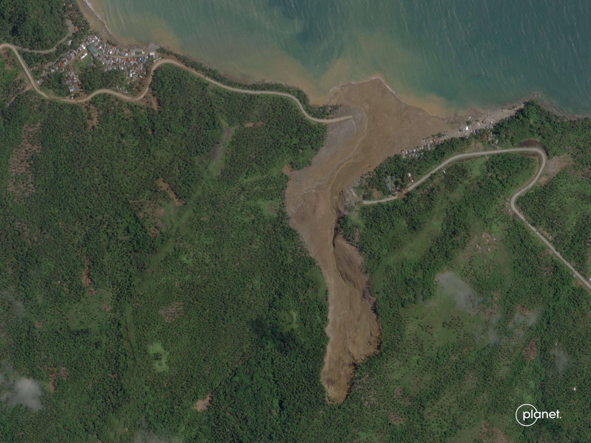
One of the largest landslides triggered by Tropical Storm Megi last month occurred at Pilar, a little to the southeast of the town of Abuyong in Leyte. This location, which is also known as Dang’s Beach Resort, suffered from one of the three very large landslides during the storm. It is located at 10.717, 125.040. The latest NDRRMC situation report lists 53 known fatalities at this site.
Planet has succeeded in collecting a high resolution satellite image of the landslide at Pilar:-

The Pilar landslide in the Philippines. Image copyright Planet, used with permission. Image dated 20 April 2022.
.
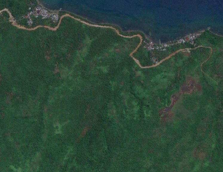
By way of comparison, this is a Google Earth image of the same area, collected in June 2016:-

Google Earth image from June 2016 showing the site of the Pilar landslide in the Philippines.
.
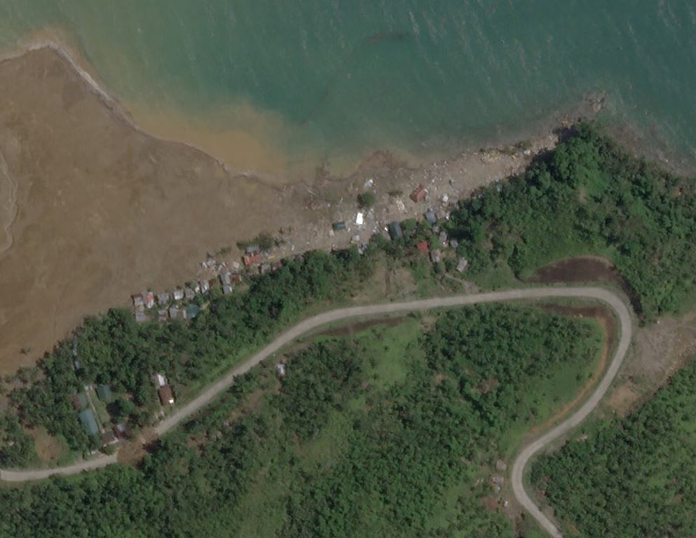
A particularly interesting aspect of this landslide is that it clearly generated destructive displacement waves when it reached the sea. The damage to the main part of the seaside resort appears to be consistent with damage caused by these waves:-

Damage caused by the Pilar landslide in the Philippines. Much of this appears to be consistent with the impact of a displacement wave. Image copyright Planet, used with permission. Image dated 20 April 2022.
.
There is a paper in the Annals of Tropical Research (Cabelin and Jadina 2019) that analyses of the soils in landslide areas in the Cadac-an Watershed, which includes the site of this landslide. It notes that:
“…it was concluded that the soils are susceptible to landslide occurrence.
“It is highly recommended to conduct constant assessment and monitoring of landslide occurrences in the area. Moreover, it is encouraged to plant more trees, prohibit tree cutting, delineate danger zone , establish more rain gauge stations and provide early warning systems to somehow prepare for the consequences brought about by landslides.”
It is hard to disagree.
.
References and acknowledgement
Planet Team (2022). Planet Application Program Interface: In Space for Life on Earth. San Francisco, CA. https://www.planet.com/
Cabelin, J.P. and Jadina, B.C. 2019. Physical characteristics of soils in landslide areas of Cadac-an Watershed in Leyte, Philippines. Annals of Tropical Research 41 (2) 11-129.
Thanks to Robert Simmon and Anne Pelligrino for their support in acquiring the image.


 Dave Petley is the Vice-Chancellor of the University of Hull in the United Kingdom. His blog provides commentary and analysis of landslide events occurring worldwide, including the landslides themselves, latest research, and conferences and meetings.
It’s ironic that the buildings off to the side were missed entirely by the slide itself, but damaged by the wave it created. There are several videos on YouTube showing a later slug of debris entering the water and creating a sizeable wave.
AN L-band radar or even Sentinel-1 C-Band data review of the area affected in the wooded upslope region may prove very interesting looking back 1-2 years. Slope displacements rarely are instantaneous — even with extreme rainfall or precipitation events….the areas that are weak would likely show change over time. Our challenge is in qualifying areas #atrisk and monitoring them as a matter of course.